Report on Bagana (Papua New Guinea) — July 2020

Bulletin of the Global Volcanism Network, vol. 45, no. 7 (July 2020)
Managing Editor: Edward Venzke.
Research and preparation by Paul Berger.
Bagana (Papua New Guinea) Ash plumes during 29 February-2 March and 1 May 2020
Please cite this report as:
Global Volcanism Program, 2020. Report on Bagana (Papua New Guinea) (Venzke, E., ed.). Bulletin of the Global Volcanism Network, 45:7. Smithsonian Institution. https://doi.org/10.5479/si.GVP.BGVN202007-255020
Bagana
Papua New Guinea
6.137°S, 155.196°E; summit elev. 1855 m
All times are local (unless otherwise noted)
Bagana lies in a nearly inaccessible mountainous tropical rainforest area of Bougainville Island in Papua New Guinea and is primarily monitored by satellite imagery of ash plumes and thermal anomalies. After a state of elevated activity that lasted through December 2018 (BGVN 43:05, 44:06, 44:12), the volcano entered a quieter period that persisted through at least May 2020. This report focuses on activity between December 2019 and May 2020.
Atmospheric clouds often obscured satellite views of the volcano during the reporting period. When the volcano could be observed, light-colored gas plumes were often observed (figure 35). Based on satellite and wind model data, the Darwin Volcanic Ash Advisory Centre (VAAC) reported that during 29 February-2 March ash plumes rose to an altitude of 1.8-2.1 km and drifted SW and N. On 1 May an ash plume rose to an altitude of 3 km and drifted NW and W. According to both Darwin VAAC volcanic ash advisories, the Aviation Color Code was Orange (second highest of four hazard levels).
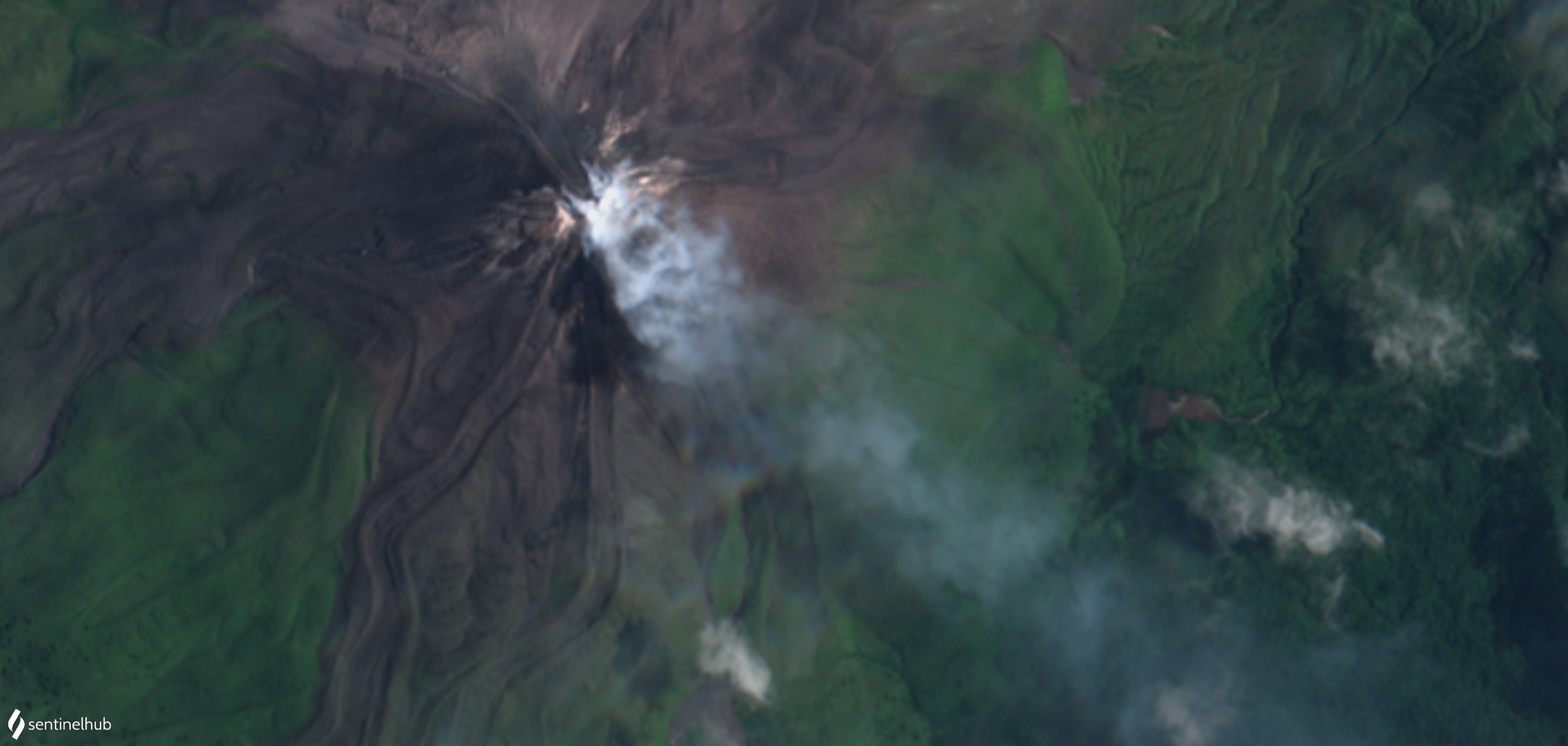 |
Figure 35. Sentinel-2 image of Bagana, showing a gas plume drifting SE on 13 March 2020, during a period when the Darwin VAAC had not reported any ash explosions (Natural Color rendering, bands 4, 3, 2). Courtesy of Sentinel Hub Playground. |
During the reporting period, the MIROVA (Middle InfraRed Observation of Volcanic Activity) volcano hotspot detection system recorded only intermittent thermal anomalies, all of which were of low radiative power. Sulfur dioxide emissions detected by satellite-based instruments over this reporting period were at low levels.
Geological Summary. Bagana volcano, in a remote portion of central Bougainville Island, is frequently active. This massive symmetrical cone was largely constructed by an accumulation of viscous andesitic lava flows. The entire edifice could have been constructed in about 300 years at its present rate of lava production. Eruptive activity is characterized by non-explosive effusion of viscous lava that maintains a small lava dome in the summit crater, although occasional explosive activity produces pyroclastic flows. Lava flows with tongue-shaped lobes up to 50 m thick and prominent levees descend the flanks on all sides.
Information Contacts: Darwin Volcanic Ash Advisory Centre (VAAC), Bureau of Meteorology, Northern Territory Regional Office, PO Box 40050, Casuarina, NT 0811, Australia (URL: http://www.bom.gov.au/info/vaac/); Sentinel Hub Playground (URL: https://www.sentinel-hub.com/explore/sentinel-playground); MIROVA (Middle InfraRed Observation of Volcanic Activity), a collaborative project between the Universities of Turin and Florence (Italy) supported by the Centre for Volcanic Risk of the Italian Civil Protection Department (URL: http://www.mirovaweb.it/); Global Sulfur Dioxide Monitoring Page, Atmospheric Chemistry and Dynamics Laboratory, NASA Goddard Space Flight Center (NASA/GSFC), 8800 Greenbelt Road, Goddard, Maryland, USA (URL: https://so2.gsfc.nasa.gov/).