Report on Ibu (Indonesia) — July 2020

Bulletin of the Global Volcanism Network, vol. 45, no. 7 (July 2020)
Managing Editor: Edward Venzke.
Edited by Kadie L. Bennis.
Ibu (Indonesia) Frequent ash emissions and summit incandescence; Strombolian explosions in March 2020
Please cite this report as:
Global Volcanism Program, 2020. Report on Ibu (Indonesia) (Bennis, K.L., and Venzke, E., eds.). Bulletin of the Global Volcanism Network, 45:7. Smithsonian Institution. https://doi.org/10.5479/si.GVP.BGVN202007-268030
Ibu
Indonesia
1.488°N, 127.63°E; summit elev. 1325 m
All times are local (unless otherwise noted)
Ibu is an active stratovolcano located along the NW coast of Halmahera Island in Indonesia. Volcanism has recently been characterized by frequent ash explosions, ash plumes, and small lava flows within the crater throughout 2019 (BGVN 45:01). Activity continues, consisting of frequent white-and-gray emissions, ash explosions, ash plumes, and lava flows. This report updates activity through June 2020, using data from the Pusat Vulkanologi dan Mitigasi Bencana Geologi (PVMBG, also known as Indonesian Center for Volcanology and Geological Hazard Mitigation, CVGHM), Darwin Volcanic Ash Advisory Centre (VAAC), and various satellites.
Volcanism during the entire reporting period dominantly consisted of white-and-gray emissions that rose 200-800 m above the summit drifting in multiple directions. The ash plume with the maximum altitude of 13.7 km altitude occurred on 16 May 2020. Sentinel-2 thermal satellite imagery detected multiple smaller hotspots within the crater throughout the reporting period.
Continuous ash emissions were reported on 6 February rising to 2.1 km altitude drifting E, accompanied by a hotspot visible in infrared satellite imagery. On 16 February, a ground observer reported an eruption that produced an ash plume rising 800 m above the summit drifting W, according to a Darwin VAAC notice. Ash plumes continued through the month, drifting in multiple directions and rising up to 2.1 km altitude. During 8-10 March, video footage captured multiple Strombolian explosions that ejected incandescent material and produced ash plumes from the summit (figures 21 and 22). Occasionally volcanic lightning was observed within the ash column, as recorded in video footage by Martin Rietze. This event was also documented by a Darwin VAAC notice, which stated that multiple ash emissions rose 2.1 km altitude drifting SE. PVMBG published a VONA notice on 10 March at 1044 reporting ash plumes rising 400 m above the summit. PVMBG and Darwin VAAC notices described intermittent eruptions on 26, 28, and 29 March, all of which produced ash plumes rising 300-800 m above the summit.
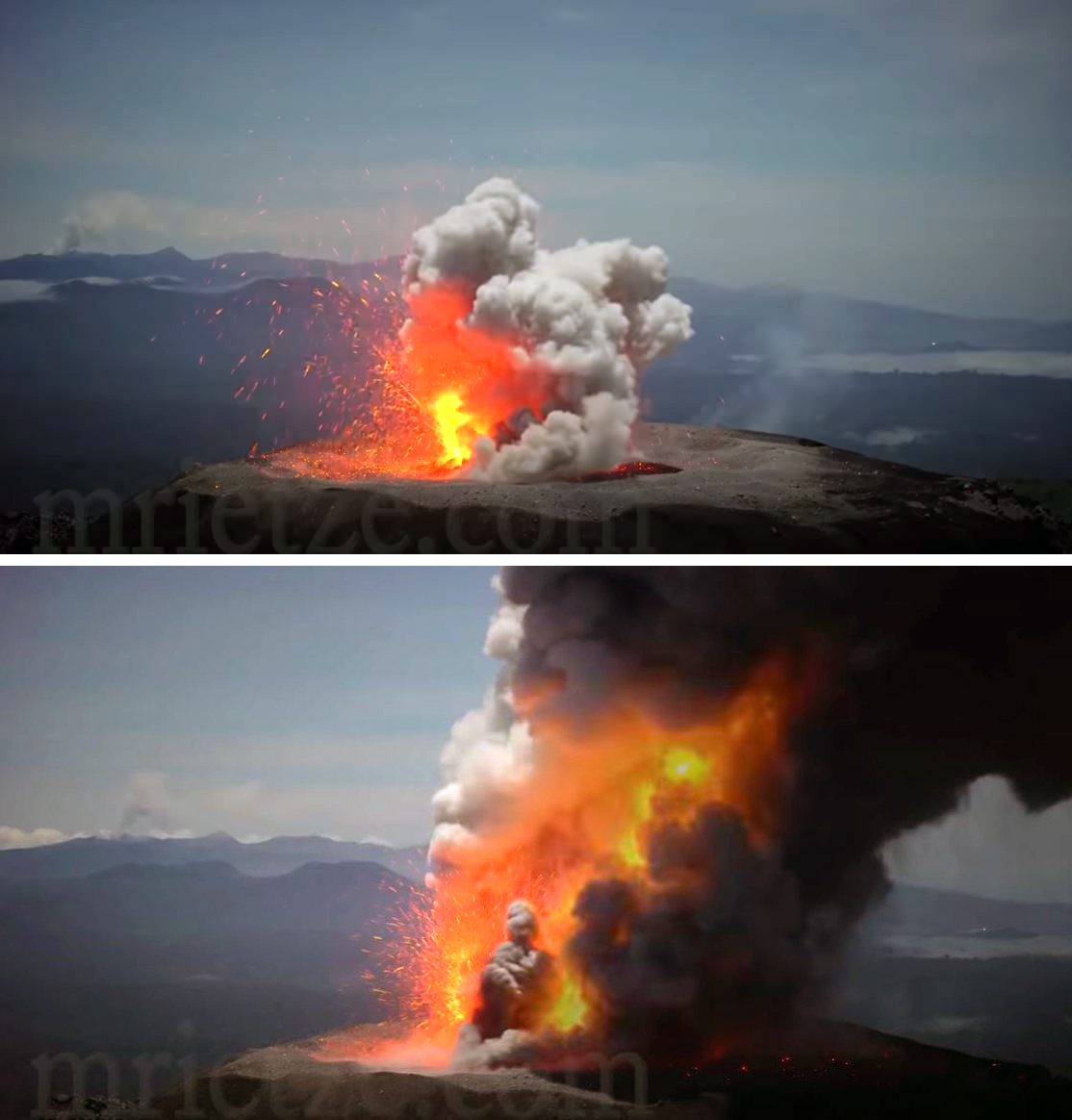 |
Figure 21. Strombolian explosions recorded at the crater summit of Ibu during 8-10 March 2020 ejected incandescent ejecta and a dense ash plume. Video footage copyright by Martin Rietze, used with permission. |
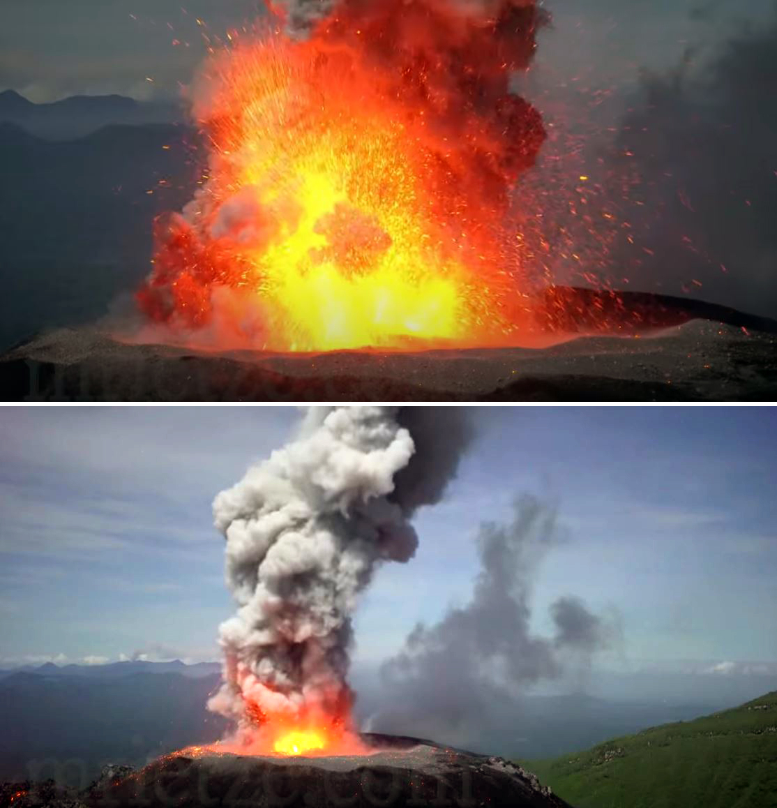 |
Figure 22. Strombolian explosions recorded at the crater summit of Ibu during 8-10 March 2020 ejected incandescent ejecta and ash. Frequent volcanic lightning was also observed. Video footage copyright by Martin Rietze, used with permission. |
A majority of days in April included white-and-gray emissions rising up to 800 m above the summit. A ground observer reported an eruption on 9 April, according to a Darwin VAAC report, and a hotspot was observed in HIMAWARI-8 satellite imagery. Minor eruptions were reported intermittently during mid-April and early to mid-May. On 12 May at 1052 a VONA from PVMBG reported an ash plume 800-1,100 m above the summit. A large short-lived eruption on 16 May produced an ash plume that rose to a maximum of 13.7 km altitude and drifted S, according to the Darwin VAAC report. By June, volcanism consisted predominantly of white-and-gray emissions rising 800 m above the summit, with an ash eruption on 15 June. This eruptive event resulted in an ash plume that rose 1.8 km altitude drifting WNW and was accompanied by a hotspot detected in HIMAWARI-8 satellite imagery, according to a Darwin VAAC notice.
The MIROVA (Middle InfraRed Observation of Volcanic Activity) system detected frequent hotspots during July 2019 through June 2020 (figure 23). In comparison, the MODVOLC thermal alerts recorded a total of 24 thermal signatures over the course of 19 different days between January and June. Many thermal signatures were captured as small thermal hotspots in Sentinel-2 thermal satellite imagery within the crater (figure 24).
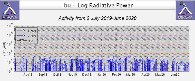 |
Figure 23. Thermal anomalies recorded at Ibu from 2 July 2019 through June 2020 as recorded by the MIROVA system (Log Radiative Power) were frequent and consistent in power. Courtesy of MIROVA. |
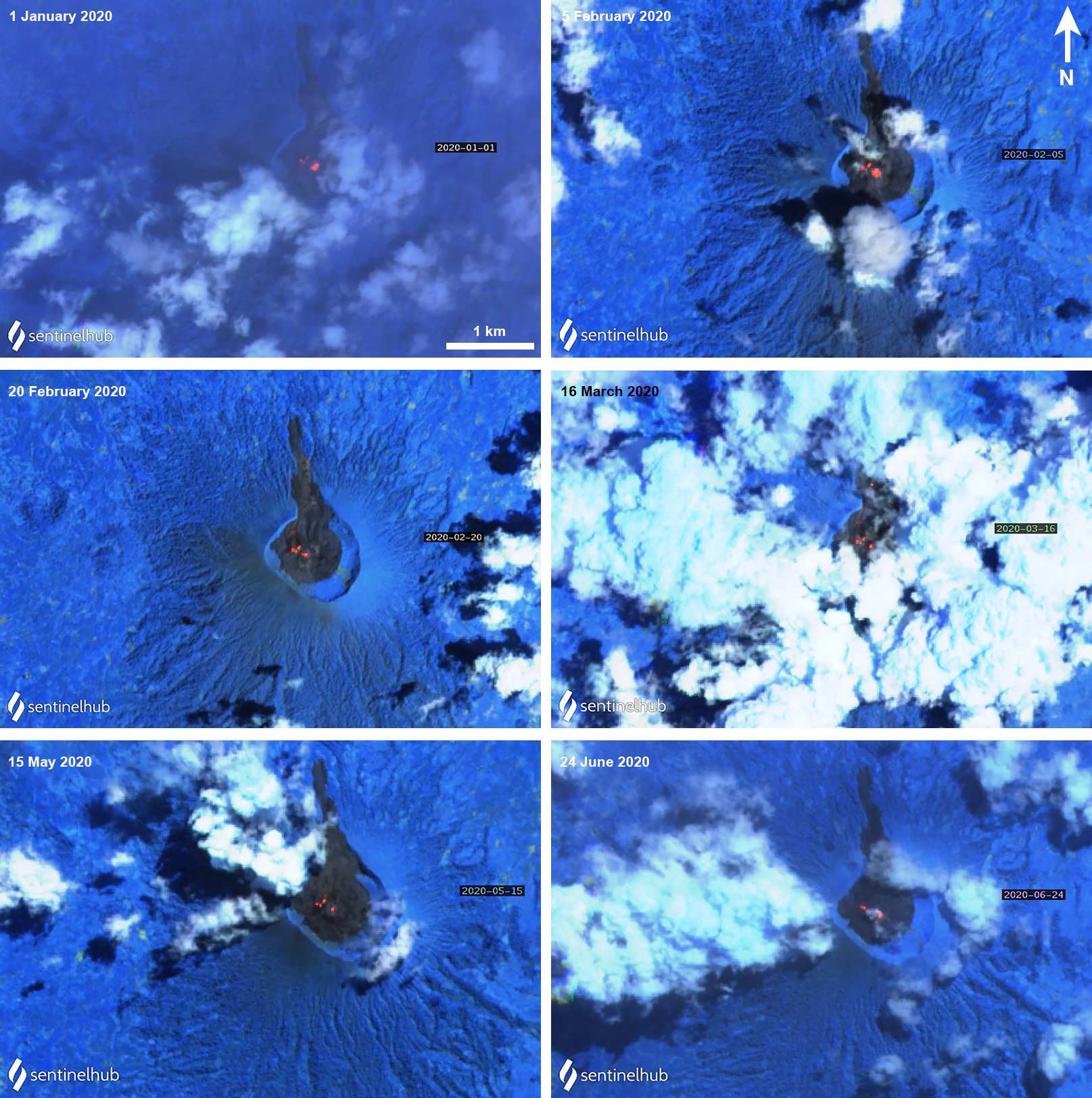 |
Figure 24. Sentinel-2 thermal satellite imagery (bands 12, 11, 8A) showed occasional thermal hotspots (bright orange) in the Ibu summit crater during January through June 2020. Courtesy of Sentinel Hub Playground. |
Geological Summary. The truncated summit of Gunung Ibu stratovolcano along the NW coast of Halmahera Island has large nested summit craters. The inner crater, 1 km wide and 400 m deep, has contained several small crater lakes. The 1.2-km-wide outer crater is breached on the N, creating a steep-walled valley. A large cone grew ENE of the summit, and a smaller one to the WSW has fed a lava flow down the W flank. A group of maars is located below the N and W flanks. The first observed and recorded eruption was a small explosion from the summit crater in 1911. Eruptive activity began again in December 1998, producing a lava dome that eventually covered much of the floor of the inner summit crater along with ongoing explosive ash emissions.
Information Contacts: Pusat Vulkanologi dan Mitigasi Bencana Geologi (PVMBG, also known as Indonesian Center for Volcanology and Geological Hazard Mitigation, CVGHM), Jalan Diponegoro 57, Bandung 40122, Indonesia (URL: http://www.vsi.esdm.go.id/); MIROVA (Middle InfraRed Observation of Volcanic Activity), a collaborative project between the Universities of Turin and Florence (Italy) supported by the Centre for Volcanic Risk of the Italian Civil Protection Department (URL: http://www.mirovaweb.it/); Hawai'i Institute of Geophysics and Planetology (HIGP) - MODVOLC Thermal Alerts System, School of Ocean and Earth Science and Technology (SOEST), Univ. of Hawai'i, 2525 Correa Road, Honolulu, HI 96822, USA (URL: http://modis.higp.hawaii.edu/); Sentinel Hub Playground (URL: https://www.sentinel-hub.com/explore/sentinel-playground); Martin Rietze, Taubenstr. 1, D-82223 Eichenau, Germany (URL: https://mrietze.com/, https://www.youtube.com/channel/UC5LzAA_nyNWEUfpcUFOCpJw/videos, video at https://www.youtube.com/watch?v=qMkfT1e4HQQ).