Report on Suwanosejima (Japan) — July 2020
Bulletin of the Global Volcanism Network, vol. 45, no. 7 (July 2020)
Managing Editor: Edward Venzke.
Edited by Kadie L. Bennis.
Suwanosejima (Japan) Frequent explosions, ash plumes, and summit incandescence in January-June 2020
Please cite this report as:
Global Volcanism Program, 2020. Report on Suwanosejima (Japan) (Bennis, K.L., and Venzke, E., eds.). Bulletin of the Global Volcanism Network, 45:7. Smithsonian Institution. https://doi.org/10.5479/si.GVP.BGVN202007-282030
Suwanosejima
Japan
29.638°N, 129.714°E; summit elev. 796 m
All times are local (unless otherwise noted)
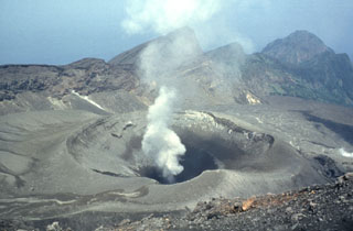
Suwanosejima is an active stratovolcano located in the northern Ryukyu Islands. Volcanism has previously been characterized by Strombolian explosions, ash plumes, and summit incandescence (BGVN 45:01), which continues to occur intermittently. A majority of this activity originates from vents within the large Otake summit crater. This report updates information during January through June 2020 using monthly reports from the Japan Meteorological Agency (JMA), the Tokyo Volcanic Ash Advisory Center (VAAC), and various satellite data.
During 3-10 January 2020, 13 explosions were detected from the Otake crater rising to 1.4 km altitude; material was ejected as far as 600 m away and ashfall was reported in areas 4 km SSW, according to JMA. Occasional small eruptive events continued during 12-17 January, which resulted in ash plumes that rose 1 km above the crater rim and ashfall was again reported 4 km SSW. Crater incandescence was visible nightly during 17-24 January, while white plumes rose as high as 700 m above the crater rim.
Nightly incandescence during 7-29 February, and 1-6 March, was accompanied by intermittent explosions that produced ash plumes rising up to 1.2 km above the crater rim (figure 44); activity during early February resulted in ashfall 4 km SSW. On 19 February an eruption produced a gray-white ash plume that rose 1.6 km above the crater (figure 45), resulting in ashfall in Toshima village (4 km SSW), according to JMA. Explosive events during 23-24 February ejected blocks onto the flanks. Two explosions were recorded during 1-6 March, which sent ash plumes as high as 900-1,000 m above the crater rim and ejected large blocks 300 m from the crater.
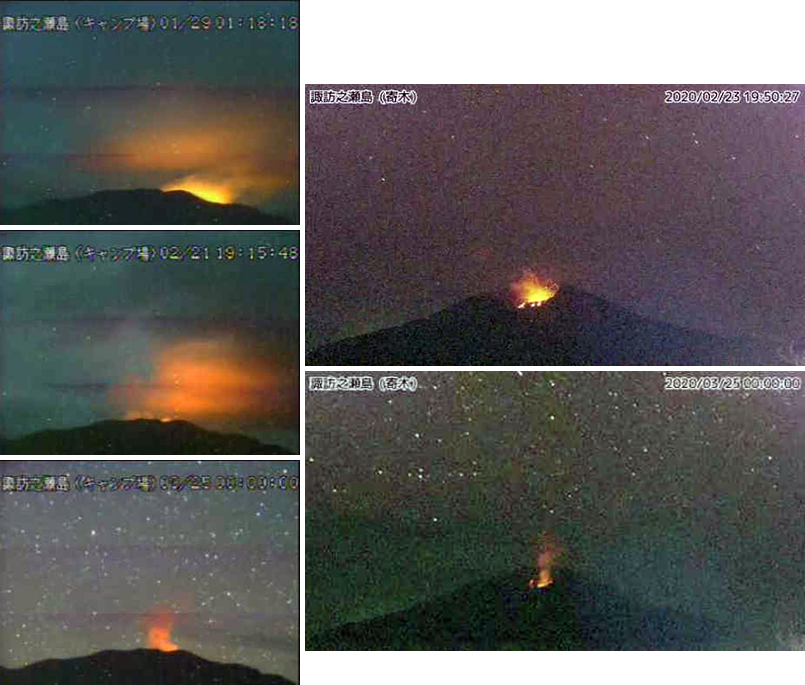 |
Figure 44. Surveillance camera images of summit incandescence at Suwanosejima on 29 January (top left), 21 (middle left) and 23 (top right) February, and 25 March (bottom left and right) 2020. Courtesy of JMA (Monthly bulletin reports 511, January, February, and March 2020). |
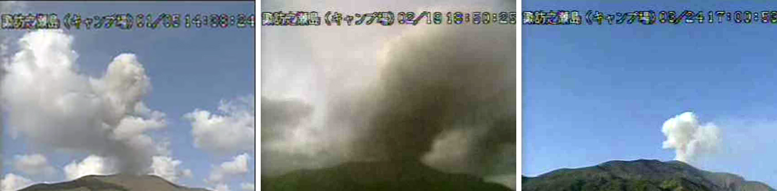 |
Figure 45. Surveillance camera images of which and white-and-gray gas-and-steam emissions rising from Suwanosejima on 5 January (top), 19 February (middle), and 24 March 2020 (bottom). Courtesy of JMA (Monthly bulletin reports 511, January, February, and March 2020). |
Nightly incandescence continued to be visible during 13-31 March, 1-10 and 17-24 April, 1-8, 15-31 May, 1-5 and 12-30 June 2020; activity during the latter part of March was relatively low and consisted of few explosive events. In contrast, incandescence was frequently accompanied by explosions in April and May. On 28 April at 0432 an eruption produced an ash plume that rose 1.6 km above the crater rim and drifted SE and E, and ejected blocks as far as 800 m from the crater. The MODVOLC thermal alerts algorithm also detected four thermal signatures during this eruption within the summit crater. An explosion at 1214 on 29 April caused glass in windows to vibrate up to 4 km SSW away while ash emissions continued to be observed following the explosion the previous day, according to the Tokyo VAAC.
During 1-8 May explosions occurred twice a day, producing ash plumes that rose as high as 1 km above the crater rim and ejecting material 400 m from the crater. An explosion on 29 May at 0210 produced an off-white plume that rose as high as 500 m above the crater rim and ejected large blocks up to 200 m above the rim. On 5 June an explosion produced gray-white plumes rising 1 km above the crater. Small eruptive events continued in late June, producing ash plumes that rose as high as 900 m above the crater rim.
MIROVA (Middle InfraRed Observation of Volcanic Activity) analysis of MODIS satellite data showed relatively stronger thermal anomalies in late February and late April 2020 with an additional six weaker thermal anomalies detected in early January (2), early February (1), mid-April (2), and mid-May (1) (figure 46). Sentinel-2 thermal satellite imagery in late January through mid-April showed two distinct thermal hotspots within the summit crater (figure 47).
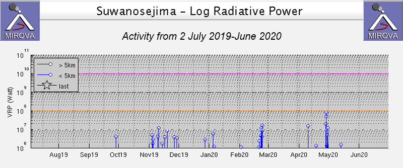 |
Figure 46. Prominent thermal anomalies at Suwanosejima during July-June 2020 as recorded by the MIROVA system (Log Radiative Power) occurred in late February and late April. Courtesy of MIROVA. |
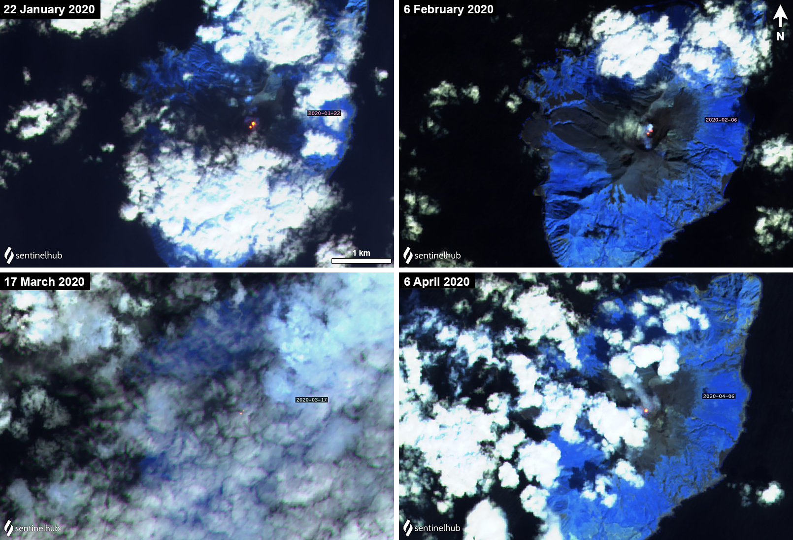 |
Figure 47. Sentinel-2 thermal satellite images showing small thermal anomalies (bright yellow-orange) from two locations within the Otake summit crater at Suwanosejima. Images with “Atmospheric penetration” (bands 12, 11, 8A) rendering; courtesy of Sentinel Hub Playground. |
Geological Summary. The 8-km-long island of Suwanosejima in the northern Ryukyu Islands consists of an andesitic stratovolcano with two active summit craters. The summit is truncated by a large breached crater extending to the sea on the E flank that was formed by edifice collapse. One of Japan's most frequently active volcanoes, it was in a state of intermittent Strombolian activity from Otake, the NE summit crater, between 1949 and 1996, after which periods of inactivity lengthened. The largest recorded eruption took place in 1813-14, when thick scoria deposits covered residential areas, and the SW crater produced two lava flows that reached the western coast. At the end of the eruption the summit of Otake collapsed, forming a large debris avalanche and creating an open collapse scarp extending to the eastern coast. The island remained uninhabited for about 70 years after the 1813-1814 eruption. Lava flows reached the eastern coast of the island in 1884. Only about 50 people live on the island.
Information Contacts: Japan Meteorological Agency (JMA), 1-3-4 Otemachi, Chiyoda-ku, Tokyo 100-8122, Japan (URL: http://www.jma.go.jp/jma/indexe.html); Tokyo Volcanic Ash Advisory Center (VAAC), 1-3-4 Otemachi, Chiyoda-ku, Tokyo 100-8122, Japan (URL: http://ds.data.jma.go.jp/svd/vaac/data/); MIROVA (Middle InfraRed Observation of Volcanic Activity), a collaborative project between the Universities of Turin and Florence (Italy) supported by the Centre for Volcanic Risk of the Italian Civil Protection Department (URL: http://www.mirovaweb.it/); Hawai'i Institute of Geophysics and Planetology (HIGP) - MODVOLC Thermal Alerts System, School of Ocean and Earth Science and Technology (SOEST), Univ. of Hawai'i, 2525 Correa Road, Honolulu, HI 96822, USA (URL: http://modis.higp.hawaii.edu/); Sentinel Hub Playground (URL: https://www.sentinel-hub.com/explore/sentinel-playground).