Report on Popocatepetl (Mexico) — August 2020

Bulletin of the Global Volcanism Network, vol. 45, no. 8 (August 2020)
Managing Editor: Edward Venzke.
Edited by Kadie L. Bennis.
Popocatepetl (Mexico) Intermittent crater incandescence and frequent ash explosions during March-July 2020
Please cite this report as:
Global Volcanism Program, 2020. Report on Popocatepetl (Mexico) (Bennis, K.L., and Venzke, E., eds.). Bulletin of the Global Volcanism Network, 45:8. Smithsonian Institution. https://doi.org/10.5479/si.GVP.BGVN202008-341090
Popocatepetl
Mexico
19.023°N, 98.622°W; summit elev. 5393 m
All times are local (unless otherwise noted)
Volcán Popocatépetl is a highly active stratovolcano in Mexico that has had frequent historical eruptions dating back to the 14th century. The current eruption has been ongoing since January 2005 and has more recently consisted of lava dome growth and destruction, frequent explosions, ash plumes, and incandescent ejecta. Activity through February 2020 was characterized by hundreds of daily low-intensity emissions that included gas-and-steam and small amounts of ash, and multiple daily minor and moderate explosions that sent ash plumes more than 1 km above the crater (BGVN 45:04). This report covers similar activity from March through July 2020 using information primarily from México's Centro Nacional de Prevención de Desastres (CENAPRED), the Washington Volcanic Ash Advisory Center (VAAC), and various satellite data.
Volcanism at Popocatépetl remained highly active, characterized by daily low-intensity emissions which included gas-and-steam emissions that contained small amounts of ash and frequent minor to moderate explosions that resulted in ash plumes rising as high as 2 km above the crater (figure 152). The Washington VAAC issued a total of 544 volcanic ash advisories spanning the reporting period with plumes reaching typically between 5.5 and 7.3 km altitude. Three VAAC notices reported three notable plumes; two rose to 7.6 km altitude during 6 and 10 March and one rose to 7.9 km altitude during 27 July. In addition, hundreds of minutes of daily tremor activity often corresponded with ash emissions. Thermal anomalies recorded by the MIROVA (Middle InfraRed Observation of Volcanic Activity) system during 19 November 2019 through July 2020 occurred frequently into early May (figure 153). During May, the frequency of these thermal anomalies decreased, but the power remained consistent to previous months; a majority of the activity was detected within 5 km of the crater summit. The MODVOLC thermal alert data recorded a total of nine thermal signatures primarily within the summit crater during 23 and 30 March, 1, 8, 23, and 25 April, 17 June, and 26 July. Significantly strong activity during late July is noted in the daily reports, the Washington VAAC notices, the MIROVA graph, and the NASA SO2 map.
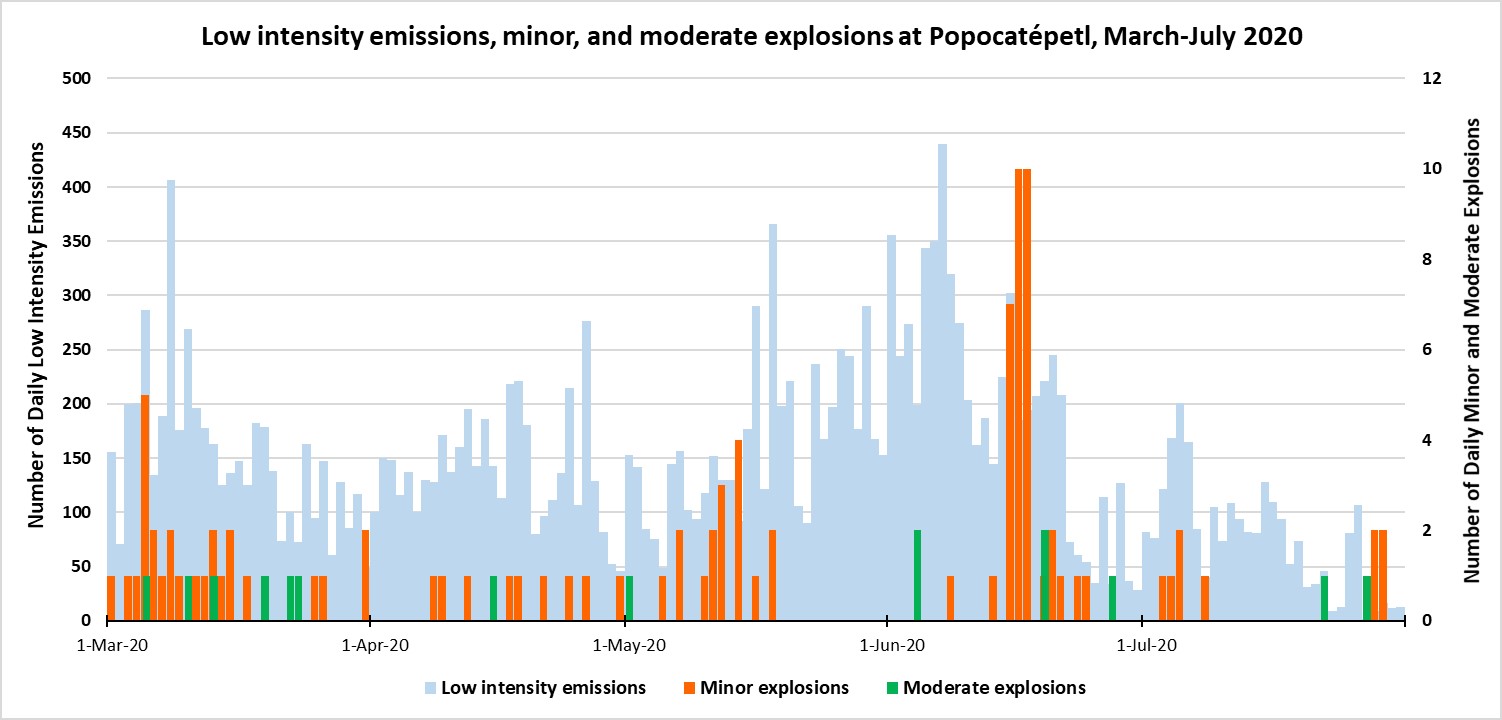 |
Figure 152. Emissions from Popocatépetl continued at a high rate throughout March-June 2020, with the rate dropping significantly starting in mid-June compared to previous months. Daily low-intensity emissions usually numbered in the hundreds (light blue, left axis), while less frequent minor (orange) and moderate (green) explosions, plotted on the right axis, occurred intermittently through July with breaks in activity during mid-May to early June and late July. Data was compiled from CENAPRED daily reports. |
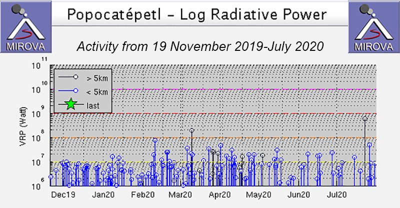 |
Figure 153. MIROVA log radiative power thermal data for Popocatépetl from 19 November 2019 through July 2020 showed constant thermal anomalies into early May 2020. During May, the frequency of the thermal anomalies decreased, but the power remained consistent; all activity was detected within 5 km of the summit. Courtesy of MIROVA. |
Sulfur dioxide emissions were measured using the Sentinel-5P/TROPOMI satellite instrument for multiple days each month from March through July 2020 (figure 154). The intensity and drift direction of these SO2 plumes varied; stronger plumes were detected in late July (figure 155). SO2 plumes were detected on most days during the reporting period. Sentinel-2 satellite imagery showed a persistent thermal anomaly occasionally accompanied by an ash plume within the summit crater during March, April, June, and July (figure 156).
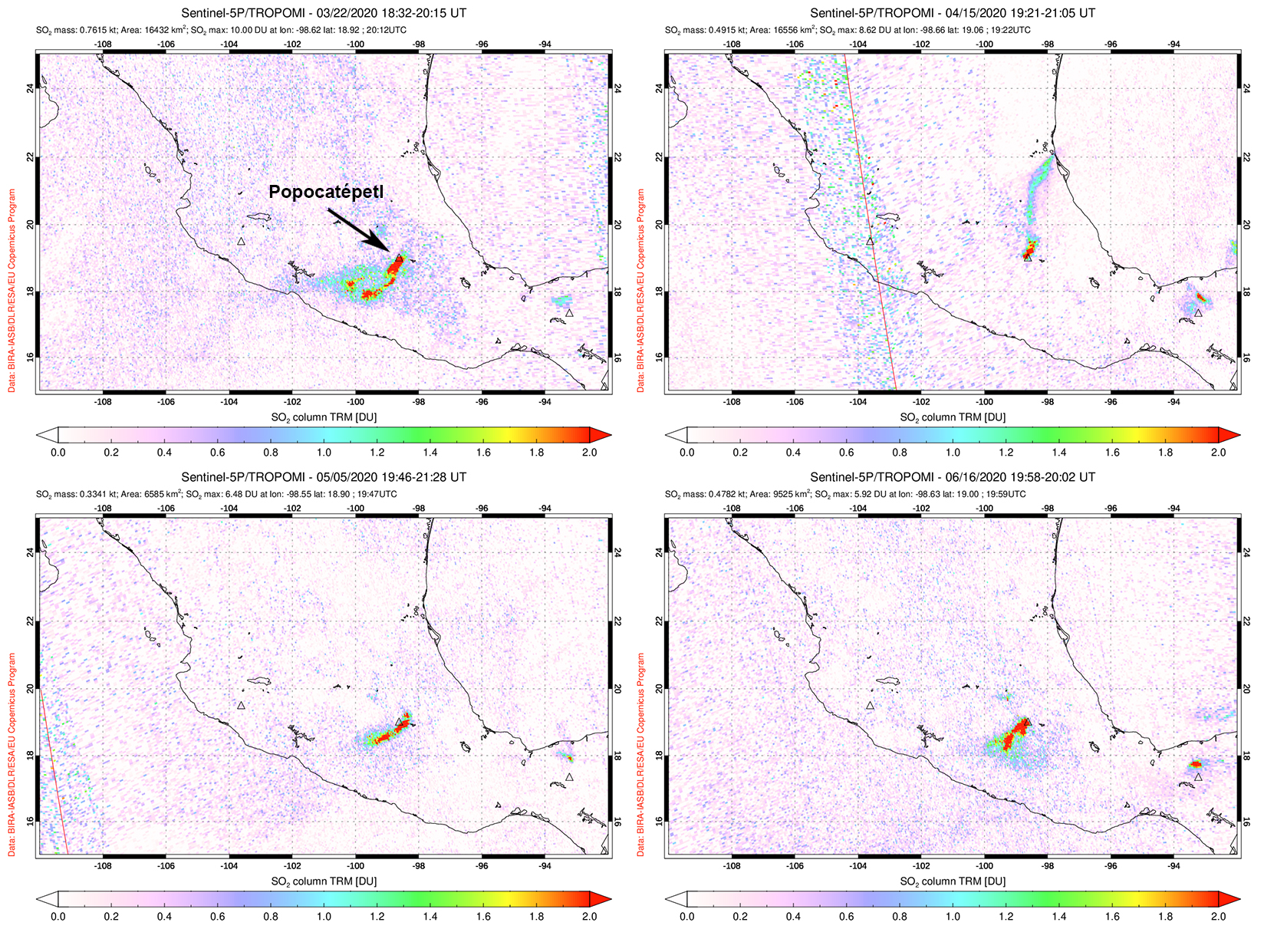 |
Figure 154. Sulfur dioxide emissions from Popocatépetl occurred frequently from March through June 2020. Plumes drifted SW on 22 March (top left), 5 May (bottom left), and 16 June (bottom right). SO2 plumes drifted N on 15 April (top right). Courtesy of NASA Global Sulfur Dioxide Monitoring Page. |
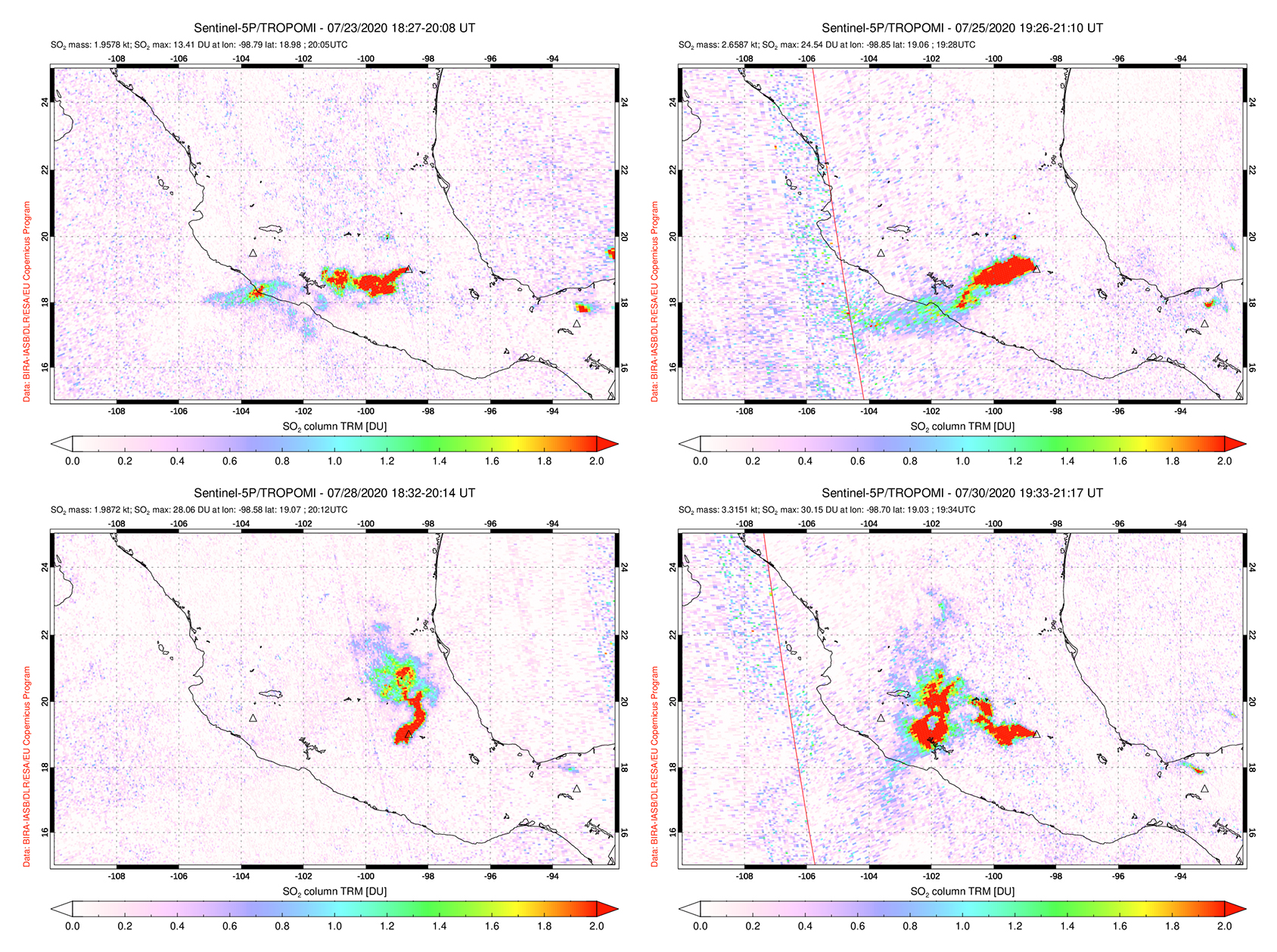 |
Figure 155. Sulfur dioxide emissions from Popocatépetl during late July 2020 were strong compared to the previous months, extending generally W, some of which reached the Pacific Ocean. Top left: 23 July. Top right: 25 July. Bottom left: 28 July. Bottom right: 30 July. Courtesy of NASA Global Sulfur Dioxide Monitoring Page. |
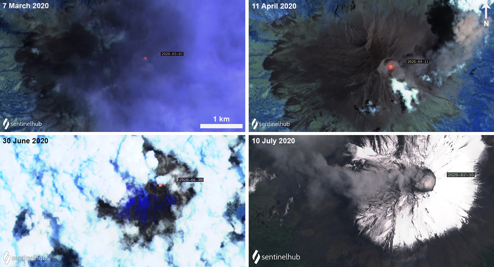 |
Figure 156. Sentinel-2 satellite imagery of Popocatépetl during March-July 2020 showing an active thermal anomaly in the summit crater and explosions with ash emissions. The bottom right image uses Natural color rendering (bands 4, 3, 2); other images use Atmospheric penetration rendering (bands 12, 11, 8A). Courtesy of Sentinel Hub Playground. |
During 7-8 March three minor explosions recorded at 1931, 2120, and 0723 were accompanied by gas-and-steam emissions containing light amounts of ash that drifted NW (figure 157). As a result, slight ashfall was detected in Tetela del Volcán (20 km SW). The next day, on 9 March, a minor explosion at 0746 resulted in slight ashfall in Amecameca (20 km NW). A moderate explosion at 0824 on 10 March was accompanied by gas-and-steam emissions containing light amounts of ash drifting NE, E, and SE. Two more explosions that day at 1307 and 1315 produced an ash plume that rose to a maximum of 2 km above the crater drifting E and SE; slight ashfall was observed in Amecameca and Tetela del Volcán. On 17 March a minor explosion at 2210 ejected incandescent material onto the flanks and produced an ash plume up to 1.2 km above the crater, drifting SE (figure 157). Gas-and-steam emissions containing some amount of ash accompanying the explosion drifted NE, SE, and E, rising 1-1.5 km above the crater. Slight ashfall was reported in Tetela del Volcán, San Andrés and Hueyapan (16 km SW), and Ocuituco (24 km SW). At night, crater incandescence was observed on 29 March in addition to an explosion at 2144 which resulted in slight ashfall in Tlalmanalco (26 km NW) and Amecameca.
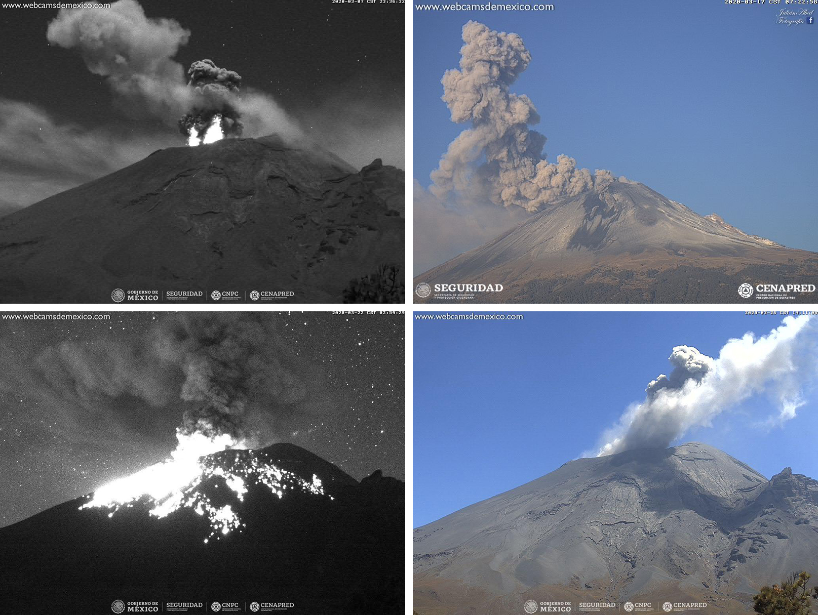 |
Figure 157. Ash plumes at Popocatépetl on 8 (top left), 17 (top right), 22 (bottom left), and 27 (bottom right) March 2020 rising above the summit. This activity was occasionally accompanied by nightly incandescence and incandescent material on the flanks (top left and bottom left). Courtesy of CENAPRED (Reporte del monitoreo de CENAPRED al volcán Popocatépetl hoy 8, 17, 22 y 27 marzo). |
Similar activity continued into April, though there were no reports of ashfall in nearby towns during this month. Volcanism primarily consisted of gas-and-steam emissions, which contained light amounts of ash. At night, occasional crater incandescence was observed throughout the month. On 8 April a minor explosion at 1715 produced an ash plume that rose to a high of 2 km above the crater. On 14 April an explosion at 2316 ejected incandescent material onto the surrounding flanks and resulted in an ash plume rising 1.5 km above the crater drifting NE (figure 158). On 21 April another minor explosion at 2143 ejected incandescent material that was accompanied by gas-and-steam emissions and a dense gray ash plume (figure 158).
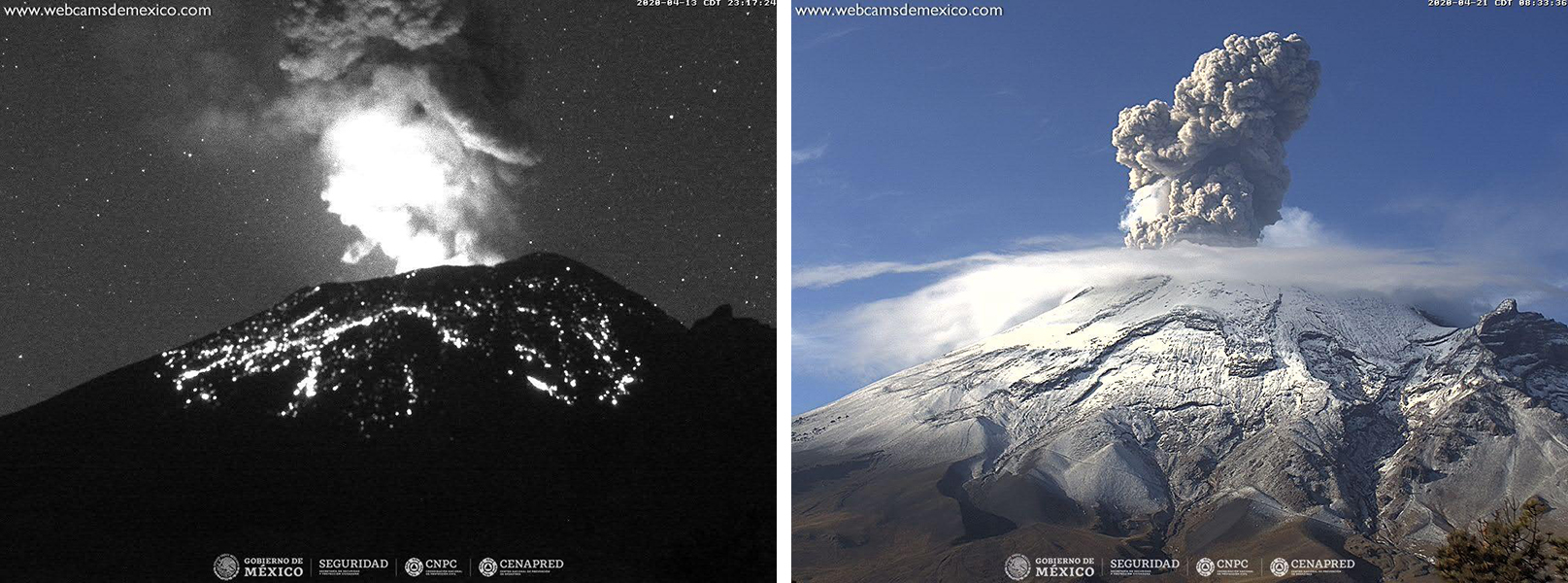 |
Figure 158. Nighttime crater incandescence and incandescent ejecta on the flanks of Popocatépetl accompanied an ash plume on 14 April 2020 (left). An ash plume rose above the crater on 21 April (right). Courtesy of CENAPRED (Reporte del monitoreo de CENAPRED al volcán Popocatépetl hoy 14 y 21 de abril). |
Continued activity during May was characterized by minor explosions, gas-and-steam emissions, incandescent ejecta, and ash plumes; intermittent crater incandescence was observed at night. Like in April, no ashfall was reported during the month. On 2 May at 1102 and 5 May at 0054 minor explosions produced ash plumes that rose 1 km above the crater and drifted SW. On 18 May two minor explosions produced a dense gray ash plume and gas-and-steam emissions drifting E and SE (figure 159). On 21 May an explosion at 0302 ejected incandescent material on the surrounding flanks, accompanied by crater incandescence, gas-and-steam emissions, and ash that drifted S and SE (figure 159).
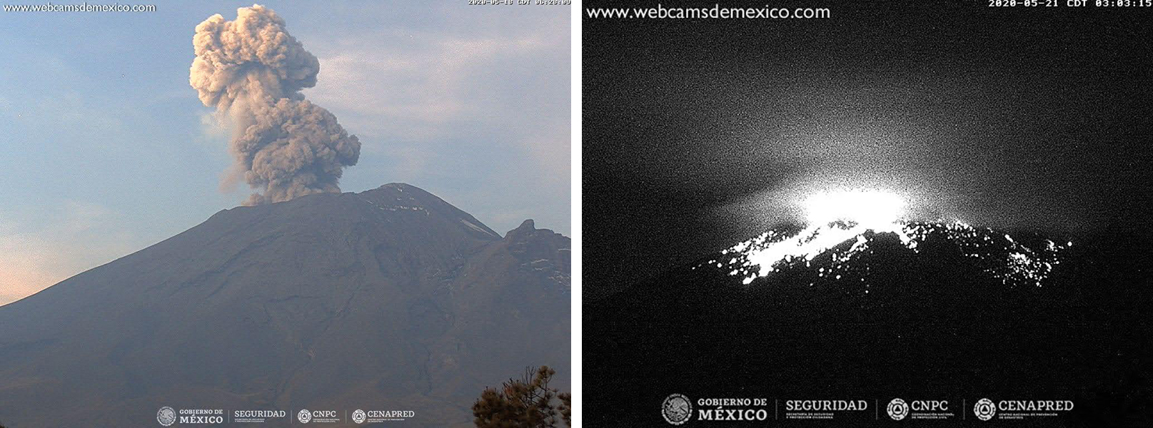 |
Figure 159. An ash plume and crater incandescence accompanied by ejecta at Popocatépetl on 18 May (left) and 21 May (right) 2020. Courtesy of CENAPRED (Reporte del monitoreo de CENAPRED al volcán Popocatépetl hoy 18 y 21 de mayo). |
During 7-8 June minor explosions at 0904 and 0253, respectively, produced ash plumes rising 1-2 km above the crater and drifting SSE and SSW. Occasional crater incandescence was observed at night, sometimes accompanied by incandescent material on the flanks. Through 13 June gas-and-steam emissions containing minor amounts of ash dominated the activity in the crater, drifting in multiple directions. An overflight conducted on 13 June by National Guard, Instituto de Geofísica de la Universidad Nacional Autónoma de México (UNAM), and CENAPRED scientists noted that the inner crater was 350-380 m in diameter and 100-150 m deep; the crater floor was covered in tephra and the remains of a lava dome were observed, which may have been seen in May. On 19 June two moderate explosions detected at 0456 and 0718, as well as a third minor explosion at 0733, ejected incandescent material onto the flanks and produced gas-and-steam emissions with light amounts of ash that drifted SW (figure 160). Some ashfall was observed in Zacualpan de Amilpas (30 km SW), Temoac, and Amayuca. An ash emission on 27 June drifted NW (figure 160), resulting in ashfall in several towns including Amecameca, Tenango del Aire (28 km NW), Temamatla, Cocotitlán, Juchitepec, Tepetlixpa (20 km W), Chalco (38 km NW) and Ozumba (18 km W), and Xochimilco (56 km NW).
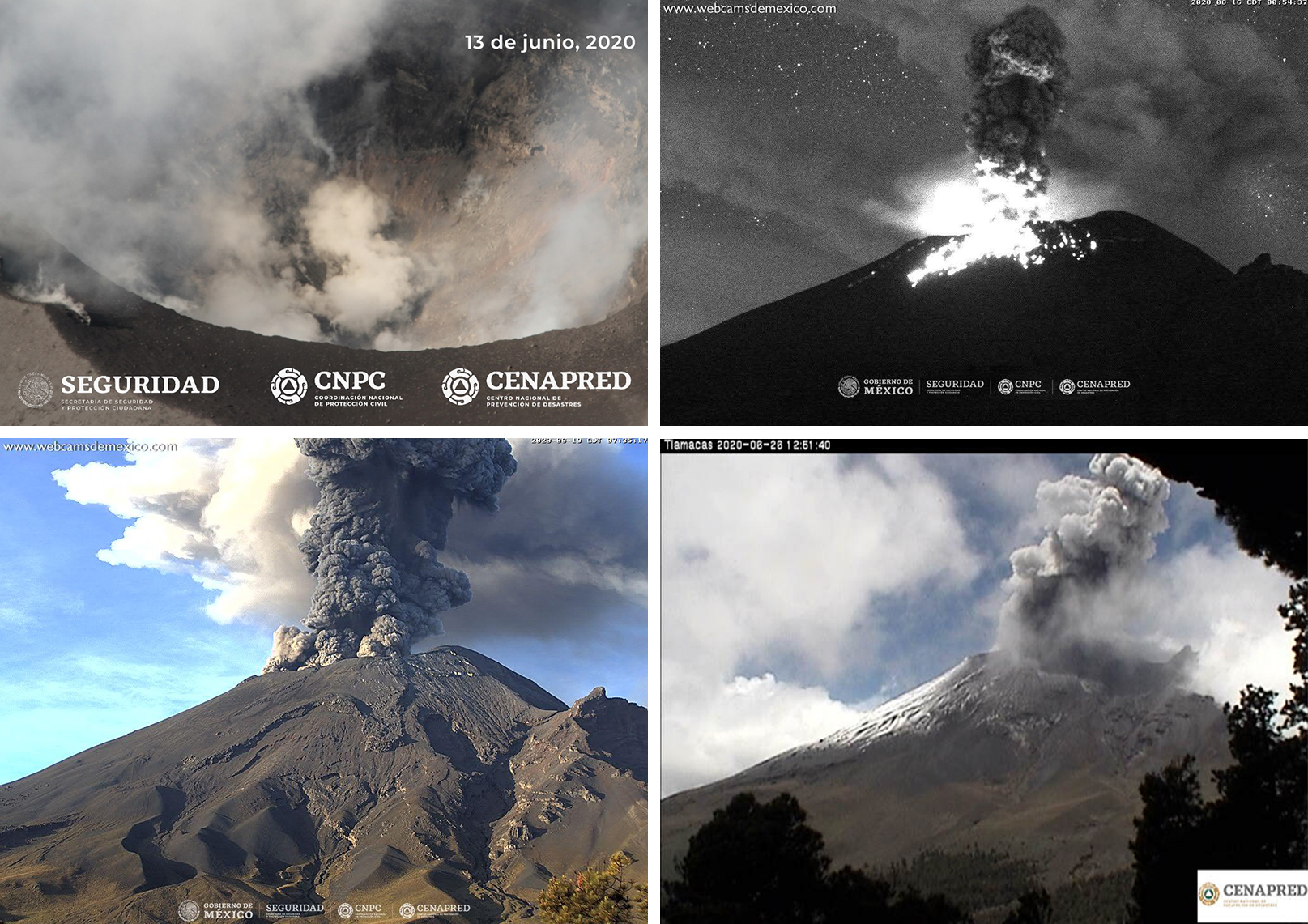 |
Figure 160. Gas-and-steam and ash plumes at Popocatépetl on 13 (top left), 16 (top right), 19 (bottom left), and 27 (bottom right) June 2020 rising above the summit occasionally accompanied by nightly incandescence and incandescent material on the flanks (top right). Courtesy of CENAPRED (Reporte del monitoreo de CENAPRED al volcán Popocatépetl hoy 13, 16, 19 y 27 de junio). |
Intermittent nightly crater incandescence and predominantly gas-and-steam emissions consisting of light amounts of ash persisted in July. During a majority of the month the explosion rate was lower compared to previous months, but by the end the rate and strength of the explosions had significantly increased. Starting on 23 July an explosion produced an ash plume accompanied by gas-and-steam emissions rising 2 km above the crater drifting SW. Explosions continued through the end of July, resulting in ash plumes up to 1.5 km above the crater, gas-and-steam emissions drifting dominantly NW and SW, dense SO2 plumes, incandescent ejecta visible on the flanks, minor ashfall, and crater incandescence (figure 161). According to the National Center for Civil Protectino Communication and Operation (CENACOM), minor ashfall was reported on 23, 25, and 27-28 July in Tetela del Volcán, Ocuituco, Atlatlahucán (30 km WSW), Yecapixtla (20 km W), Yautepec (50 km WSW), Jiutepec (60 km WSW), Ayapango (22 km NW), Temamatla, Ecatepec, Valle de Chalco, Texcoco, Tezoyuca, Tepetlaoxtoc, Naucalpan, Atizapán, Huixquilucan, Nicolás Romero, and Tlalnepantla (40 km W), as well as in Tlalmanalco, Juchitepec, Tepetlixpa, Atlautla (17 km W), Ozumba, Ecatzingo (15 km SW), Xochimilco, Iztacalco (64 km NW), Iztapalapa (57 km NW), and Gustavo A Madero.
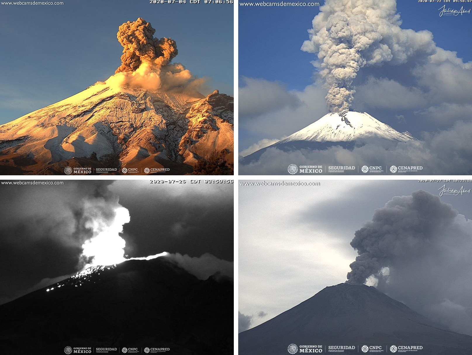 |
Figure 161. Ash plumes at Popocatépetl on 4 (top left), 22 (top right), 26 (bottom left), and 28 (bottom right) July 2020 rising above the summit occasionally accompanied by nightly incandescence and incandescent material on the flanks (bottom left). Courtesy of CENAPRED (Reporte del monitoreo de CENAPRED al volcán Popocatépetl hoy 4, 22, 26 y 28 de julio). |
Geological Summary. Volcán Popocatépetl, whose name is the Aztec word for smoking mountain, rises 70 km SE of Mexico City to form North America's 2nd-highest volcano. The glacier-clad stratovolcano contains a steep-walled, 400 x 600 m wide crater. The generally symmetrical volcano is modified by the sharp-peaked Ventorrillo on the NW, a remnant of an earlier volcano. At least three previous major cones were destroyed by gravitational failure during the Pleistocene, producing massive debris-avalanche deposits covering broad areas to the south. The modern volcano was constructed south of the late-Pleistocene to Holocene El Fraile cone. Three major Plinian eruptions, the most recent of which took place about 800 CE, have occurred since the mid-Holocene, accompanied by pyroclastic flows and voluminous lahars that swept basins below the volcano. Frequent historical eruptions, first recorded in Aztec codices, have occurred since Pre-Columbian time.
Information Contacts: Centro Nacional de Prevención de Desastres (CENAPRED), Av. Delfín Madrigal No.665. Coyoacan, México D.F. 04360, México (URL: http://www.cenapred.unam.mx/), Daily Report Archive http://www.cenapred.unam.mx:8080/reportesVolcanGobMX/BuscarReportesVolcan); Washington Volcanic Ash Advisory Center (VAAC), Satellite Analysis Branch (SAB), NOAA/NESDIS OSPO, NOAA Science Center Room 401, 5200 Auth Rd, Camp Springs, MD 20746, USA (URL: www.ospo.noaa.gov/Products/atmosphere/vaac, archive at: http://www.ssd.noaa.gov/VAAC/archive.html); Global Sulfur Dioxide Monitoring Page, Atmospheric Chemistry and Dynamics Laboratory, NASA Goddard Space Flight Center (NASA/GSFC), 8800 Greenbelt Road, Goddard, Maryland, USA (URL: https://so2.gsfc.nasa.gov/); MIROVA (Middle InfraRed Observation of Volcanic Activity), a collaborative project between the Universities of Turin and Florence (Italy) supported by the Centre for Volcanic Risk of the Italian Civil Protection Department (URL: http://www.mirovaweb.it/); Sentinel Hub Playground (URL: https://www.sentinel-hub.com/explore/sentinel-playground).