Report on Pacaya (Guatemala) — August 2020

Bulletin of the Global Volcanism Network, vol. 45, no. 8 (August 2020)
Managing Editor: Edward Venzke.
Edited by Kadie L. Bennis.
Pacaya (Guatemala) Strombolian explosions, multiple lava flows, and the formation of a small cone during February-July 2020
Please cite this report as:
Global Volcanism Program, 2020. Report on Pacaya (Guatemala) (Bennis, K.L., and Venzke, E., eds.). Bulletin of the Global Volcanism Network, 45:8. Smithsonian Institution. https://doi.org/10.5479/si.GVP.BGVN202008-342110
Pacaya
Guatemala
14.382°N, 90.601°W; summit elev. 2569 m
All times are local (unless otherwise noted)
Pacaya, located in Guatemala, is a highly active volcano that has previously produced continuous Strombolian explosions, multiple lava flows, and the formation of a small cone within the crater due to the constant deposition of ejected material (BGVN 45:02). This reporting period updates information from February through July 2020 consisting of similar activity that dominantly originates from the Mackenney crater. Information primarily comes from reports by the Instituto Nacional de Sismologia, Vulcanologia, Meteorologia e Hydrologia (INSIVUMEH) in Guatemala and various satellite data.
Strombolian explosions were recorded consistently throughout this reporting period. During February 2020, explosions ejected incandescent material 100 m above the Mackenney crater. At night and during the early morning the explosions were accompanied by incandescence from lava flows. Multiple lava flows were active during most of February, traveling primarily down the SW and NW flanks and reaching 500 m on 25 February. On 5 February the lava flow on the SW flank divided into three flows measuring 200, 150, and 100 m. White and occasionally blue gas-and-steam emissions rose up to 2.7 km altitude on 11 and 14 February and drifted in multiple directions. On 16 February Matthew Watson utilized UAVs (Unmanned Aerial Vehicle) to take detailed, close up photos of Pacaya and report that there were five active vents at the summit exhibiting lava flows from the summit, gas-and-steam emissions, and small Strombolian explosions (figure 122).
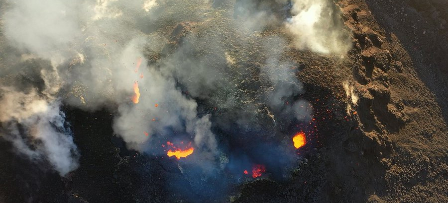 |
Figure 122. Drone image of active summit vents at Pacaya on 16 February 2020 with incandescence and white gas-and-steam emissions. Courtesy of Matthew Watson, University of Bristol, posted on 17 February 2020. |
Activity remained consistent during March with Strombolian explosions ejecting material 100 m above the crater accompanied by occasional incandescence and white and occasionally blue gas-and-steam emissions drifting in multiple directions. Multiple lava flows were detected on the NW and W flanks reaching as far as 400 m on 9-10 March.
In April, frequent Strombolian explosions were accompanied by active lava flows moving dominantly down the SW flank and white gas-and-steam emissions. These repeated explosions ejected material up to 100 m above the crater and then deposited it within the Mackenney crater, forming a small cone. On 27 April seismicity increased at 2140 due to a lava flow moving SW as far as 400 m (figure 123); there were also six strong explosions and a fissure opened on the NW flank in front of the Los Llanos Village, allowing gas-and-steam to rise.
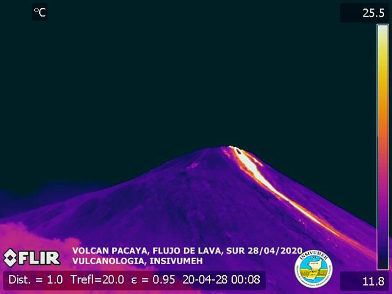 |
Figure 123. Infrared image of Pacaya on 28 April 2020, showing a lava flow approximately 500 m long and moving down the S flank on the day after seismicity increased and six strong explosions were detected. Courtesy of ISIVUMEH (Reporte Volcán de Pacaya July 2020). |
During May, Strombolian explosions continued to eject incandescent material up to 100 m above the Mackenney crater, accompanied by active lava flows on 1-2, 17-18, 22, 25-26, and 29-30 May down the SE, SW, NW, and NE flanks up to 700 m on 30 May. White gas-and-steam emissions continued to be observed up to 100 m above the crater drifting in multiple directions. Between the end of May and mid-June, the plateau between the Mackenney cone and the Cerro Chiquito had become inundated with lava flows (figure 124).
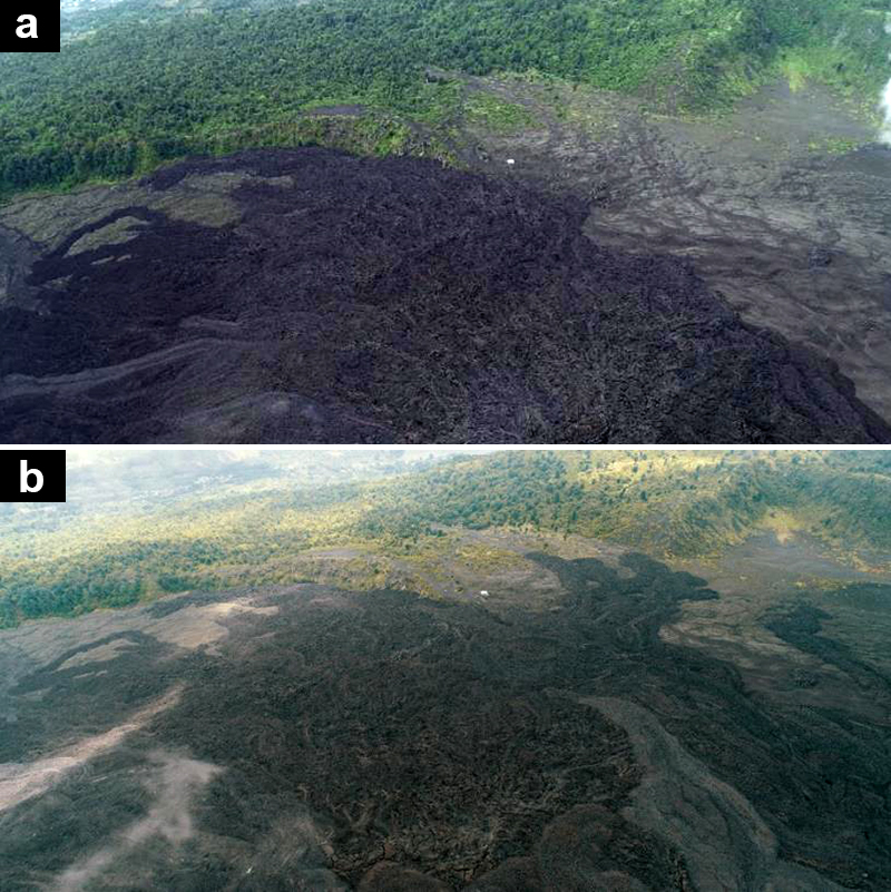 |
Figure 124. Aerial views of the lava flows at Pacaya to the NW during a) 18 September 2019 and b) 16 June 2020 showing the lava flow advancement toward the Cerro Chiquito. Both images have been color corrected. Courtesy of INSIVUMEH (Reporte Volcán de Pacaya July 2020). |
Lava flows extended 700 m on 8 June down multiple flanks. On 9 June, a lava flow traveled N and NW 500 m and originating from a vent on the N flank about 100 m below the Mackenney crater. Active lava flows continued to originate from this vent through at least 19 June while white gas-and-steam emissions were observed rising 300 m above the crater. At night and during the early mornings of 24 and 29 June Strombolian explosions were observed ejecting incandescent material up to 200 m above the crater (figure 125). These explosions continued to destroy and then rebuild the small cone within the Mackenney crater with fresh ejecta. Active lava flows on the SW flank were mostly 100-600 m long but had advanced to 2 km by 30 June.
On 10 July a 1.2 km lava flow divided in two which moved on the NE and N flanks. On 11 July, another 800 m lava flow divided in two, on the N and NE flanks (figure 126). On 14 and 19 July, INSIVUMEH registered constant seismic tremors and stated they were associated with the lava flows. No active lava flows were observed on 18-19 July, though some may have continued to advance on the SW, NW, N, and NE flanks. On 20 July, lava emerged from a vent at the NW base of the Mackenney cone near Cerro Chino, extending SE. Strombolian explosions ejected incandescent material up to 200 m above the crater on 22 July, accompanied by active incandescent lava flows on the SW, N, NW, NE, and W flanks. Three lava flows on the NW flank were observed on 22-24 July originating from the base of the Mackenney cone. Explosive activity during 22 July vibrated the windows and roofs of the houses in the villages of San Francisco de Sales, El Patrocinio, El Rodeo, and others located 4 km from the volcano. The lava flow activity had decreased by 25 July, but remnants of the lava flow on the NW flank persisted with weak incandescence observed at night, which was no longer observed by 26 July. Strombolian explosions continued to be detected through the rest of the month, accompanied by frequent white gas-and-steam emissions that extended up to 2 km from the volcano; no active lava flows were observed.
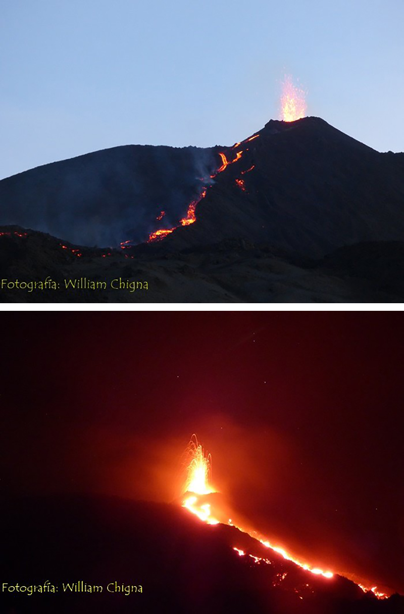 |
Figure 125. Photos of Pacaya on 11 July 2020 showing Strombolian explosions and lava flows moving down the N and NE flanks. Courtesy of William Chigna, CONRED, posted on 12 July 2020. |
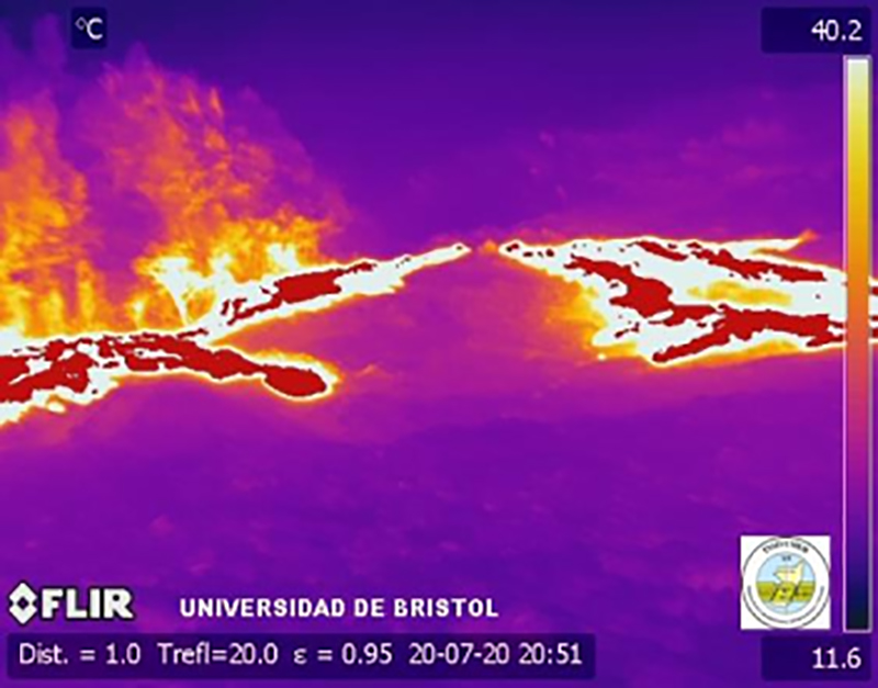 |
Figure 126. Infrared image of Pacaya on 20 July 2020 showing a hot lava flow accompanied by gas-and-steam emissions. Courtesy of INSIVUMEH (BEPAC 47 Julio 2020-22). |
During February through July 2020, multiple lava flows and thermal anomalies within the Mackenney crater were detected in Sentinel-2 thermal satellite imagery (figure 127). These lava flows were observed moving down multiple flanks and were occasionally accompanied by white gas-and-steam emissions. Thermal anomalies were also recorded by the MIROVA (Middle InfraRed Observation of Volcanic Activity) system during 10 August through July 2020 within 5 km of the crater summit (figure 128). There were a few breaks in thermal activity from early to mid-March, late April, early May, and early June; however, each of these gaps were followed by a pulse of strong and frequent thermal anomalies. According to the MODVOLC algorithm, 77 thermal alerts were recorded within the summit crater during February through July 2020.
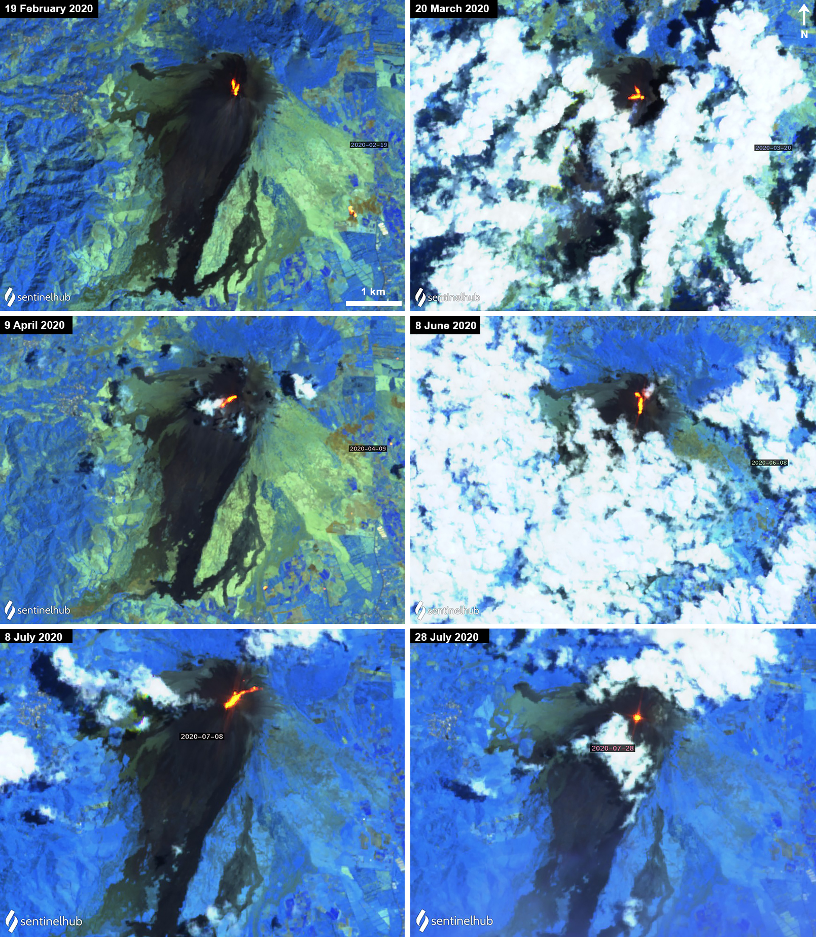 |
Figure 127. Sentinel-2 thermal satellite images of Pacaya showing thermal activity (bright yellow-orange) primarily as lava flows originating from the summit crater during February to July 2020 frequently accompanied by white gas-and-steam emissions. All images with "Atmospheric penetration" (bands 12, 11, 8A) rendering; courtesy of Sentinel Hub Playground. |
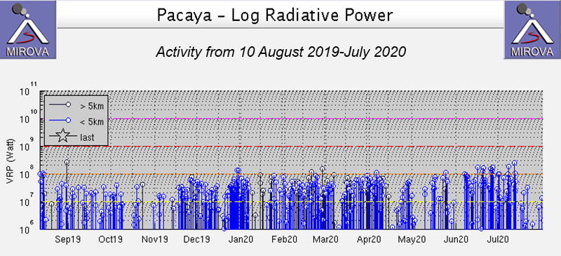 |
Figure 128. The MIROVA thermal activity graph (Log Radiative Power) at Pacaya during 10 August to July 2020 shows strong, frequent thermal anomalies through late July with brief gaps in activity during early to mid-March, late April, early May, and early June. Courtesy of MIROVA. |
Geological Summary. Eruptions from Pacaya are frequently visible from Guatemala City, the nation's capital. This complex basaltic volcano was constructed just outside the southern topographic rim of the 14 x 16 km Pleistocene Amatitlán caldera. A cluster of dacitic lava domes occupies the southern caldera floor. The post-caldera Pacaya massif includes the older Pacaya Viejo and Cerro Grande stratovolcanoes and the currently active Mackenney stratovolcano. Collapse of Pacaya Viejo between 600 and 1,500 years ago produced a debris-avalanche deposit that extends 25 km onto the Pacific coastal plain and left an arcuate scarp inside which the modern Pacaya volcano (Mackenney cone) grew. The NW-flank Cerro Chino crater was last active in the 19th century. During the past several decades, activity has consisted of frequent Strombolian eruptions with intermittent lava flow extrusion that has partially filled in the caldera moat and covered the flanks of Mackenney cone, punctuated by occasional larger explosive eruptions that partially destroy the summit.
Information Contacts: Instituto Nacional de Sismologia, Vulcanologia, Meteorologia e Hydrologia (INSIVUMEH), Unit of Volcanology, Geologic Department of Investigation and Services, 7a Av. 14-57, Zona 13, Guatemala City, Guatemala (URL: http://www.insivumeh.gob.gt/); MIROVA (Middle InfraRed Observation of Volcanic Activity), a collaborative project between the Universities of Turin and Florence (Italy) supported by the Centre for Volcanic Risk of the Italian Civil Protection Department (URL: http://www.mirovaweb.it/); Hawai'i Institute of Geophysics and Planetology (HIGP) - MODVOLC Thermal Alerts System, School of Ocean and Earth Science and Technology (SOEST), Univ. of Hawai'i, 2525 Correa Road, Honolulu, HI 96822, USA (URL: http://modis.higp.hawaii.edu/); Sentinel Hub Playground (URL: https://www.sentinel-hub.com/explore/sentinel-playground); Matthew Watson, School of Earth Sciences at the University of Bristol (Twitter: @Matthew__Watson, https://twitter.com/Matthew__Watson); William Chigna, CONRED (URL: https://twitter.com/william_chigna).