Report on Nevado del Ruiz (Colombia) — August 2020

Bulletin of the Global Volcanism Network, vol. 45, no. 8 (August 2020)
Managing Editor: Edward Venzke.
Edited by A. Elizabeth Crafford.
Nevado del Ruiz (Colombia) Lava dome confirmed inside Arenas crater; intermittent thermal anomalies and ash emissions, January-June 2020
Please cite this report as:
Global Volcanism Program, 2020. Report on Nevado del Ruiz (Colombia) (Crafford, A.E., and Venzke, E., eds.). Bulletin of the Global Volcanism Network, 45:8. Smithsonian Institution. https://doi.org/10.5479/si.GVP.BGVN202008-351020
Nevado del Ruiz
Colombia
4.892°N, 75.324°W; summit elev. 5279 m
All times are local (unless otherwise noted)
Colombia’s broad, glacier-capped Nevado del Ruiz has an eruption history documented back 8,600 years, and historical observations since 1570. It’s profound notoriety stems from an eruption on 13 November 1985 that produced an ash plume and pyroclastic flows onto the glacier, triggering large lahars that washed down 11 valleys, inundating most severely the towns of Armero (46 km W) and Chinchiná (34 km E) where approximately 25,000 residents were killed. It remains the second deadliest volcanic eruption of the 20th century after Mt. Pelee killed 28,000 in 1902. Ruiz remained quiet for 20 years after the September 1985-July 1991 eruption until a new explosive event occurred in February 2012; a series of explosive events lasted into 2013. Renewed activity beginning in November 2014 included ash and gas-and-steam plumes, ashfall, and the appearance of a lava dome inside the Arenas crater in August 2015 which has regularly displayed thermal anomalies through 2019. This report covers ongoing activity from January-June 2020 using information primarily from reports by the Servicio Geologico Colombiano (SGC) and the Observatorio Vulcanológico y Sismológico de Manizales, the Washington Volcanic Ash Advisory Center (VAAC) notices, and various sources of satellite data.
Gas and ash emissions continued at Nevado del Ruiz throughout January-June 2020; they generally rose to 5.8-6.1 km altitude with the highest reported plume at 7 km altitude during early March. SGC confirmed the presence of the growing lava dome inside Arenas crater during an overflight in January; infrared satellite imagery indicated a continued heat source from the dome through April. SGC interpreted repeated episodes of ‘drumbeat seismicity’ as an indication of continued dome growth throughout the period. Small- to moderate-density sulfur dioxide emissions were measured daily with satellite instruments. The MIROVA graph of thermal activity indicated a heat source consistent with a growing dome from January through April (figure 102).
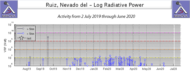 |
Figure 102. The MIROVA graph of thermal activity at Nevado del Ruiz from 2 July 2019 through June 2020 indicated persistent thermal anomalies from mid-November 2019-April 2020. Courtesy of MIROVA. |
Activity during January-March 2020. During January 2020 some of the frequent tremor seismic events were associated with gas and ash emissions, and several episodes of "drumbeat” seismicity were recorded; they have been related by SGC to the growth of the lava dome on the floor of the Arenas crater. An overflight on 10 January, with the support of the Colombian Air Force, confirmed the presence of the dome which was first proposed in August 2015 (BGVN 42:06) (figure 103). The Arenas crater had dimensions of 900 x 980 m elongate to the SW-NE and was about 300 m deep (figure 104). The dome inside the crater was estimated to be 173 m in diameter and 60 m high with an approximate volume of 1,500,000 m3 (figures 105 and 106). In addition to the dome, the scientists also noted ash deposits on the summit ice cap (figure 107). The Washington VAAC reported an ash plume on 19 January that rose to 5.5 km altitude and drifted SW, dissipating quickly. On 30 January they reported an ash plume visible in satellite imagery extending 15 km NW from the summit at 5.8 km altitude. A single MODVOLC alert was issued on 15 January and data from the VIIRS satellite instrument reported thermal anomalies inside the summit crater on 14 days of the month. Sulfur dioxide plumes with DU values greater than 2 were recorded by the TROPOMI satellite instrument daily during the month.
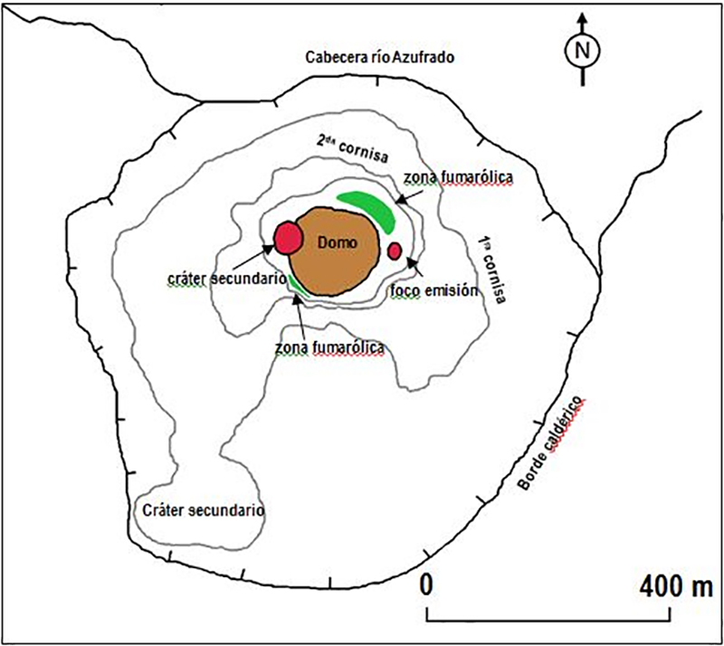 |
Figure 103. SGC confirmed the presence of a lava dome inside the Arenas crater at Nevado del Ruiz on 10 January 2020. The dome is shown in brown, and zones of fumarolic activity are labelled around the dome. Courtesy of SGC (El Nuevo Domo de Lava del Volcán Nevado del Ruiz y la Geomorfología Actual del Cráter Arenas 2020). |
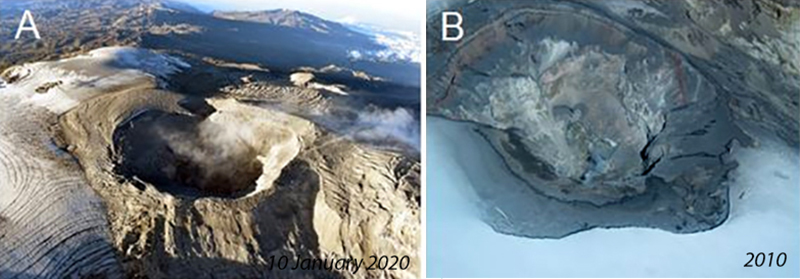 |
Figure 104. A view of the Arenas crater at the summit of Nevado del Ruiz on 10 January 2020 (left) is compared with a view from 2010 (right). They were both taken during overflights supported by the Colombian Air Force (FAC). Ash deposits on the ice fields are visible in both images. Fumarolic activity rises from the inner walls of the crater in January 2020. Courtesy of SGC (El Nuevo Domo de Lava del Volcán Nevado del Ruiz y la Geomorfología Actual del Cráter Arenas 2020). |
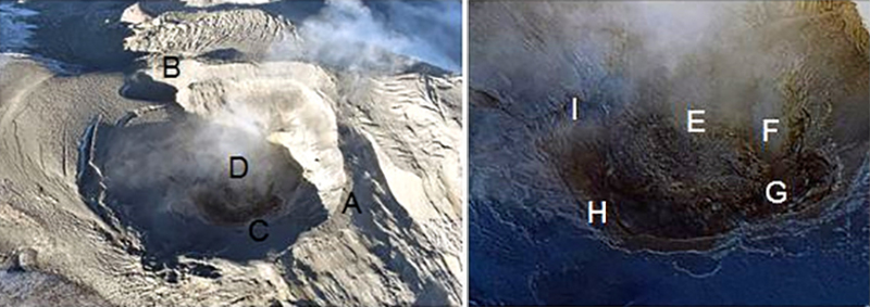 |
Figure 105. The dome inside the Arenas crater at Nevado del Ruiz appeared dark against the crater rim and ash-covered ice field on 10 January 2020. Features observed include (A) the edge of the Arenas crater, (B) a secondary crater 150 m in diameter located to the west, (C) interior cornices, (D) the lava dome, (E) a depression in the center of the dome caused by possible subsidence and cooling of the lava, (F) a source of gas and ash emission with a diameter of approximately 15 m (secondary crater), and (G, H, and I) several sources of gas emission located around the crater. Courtesy of SGC (El Nuevo Domo de Lava del Volcán Nevado del Ruiz y la Geomorfología Actual del Cráter Arenas 2020). |
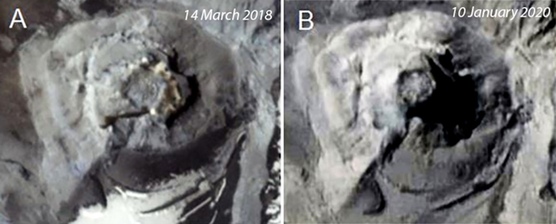 |
Figure 106. Images of the summit of Nevado del Ruiz captured by the PlanetScope satellite system on 14 March 2018 (A) and 10 January 2020 (B) show the lava dome at the bottom of Arenas crater. Courtesy Planet Lab Inc. and SGC (El Nuevo Domo de Lava del Volcán Nevado del Ruiz y la Geomorfología Actual del Cráter Arenas 2020). |
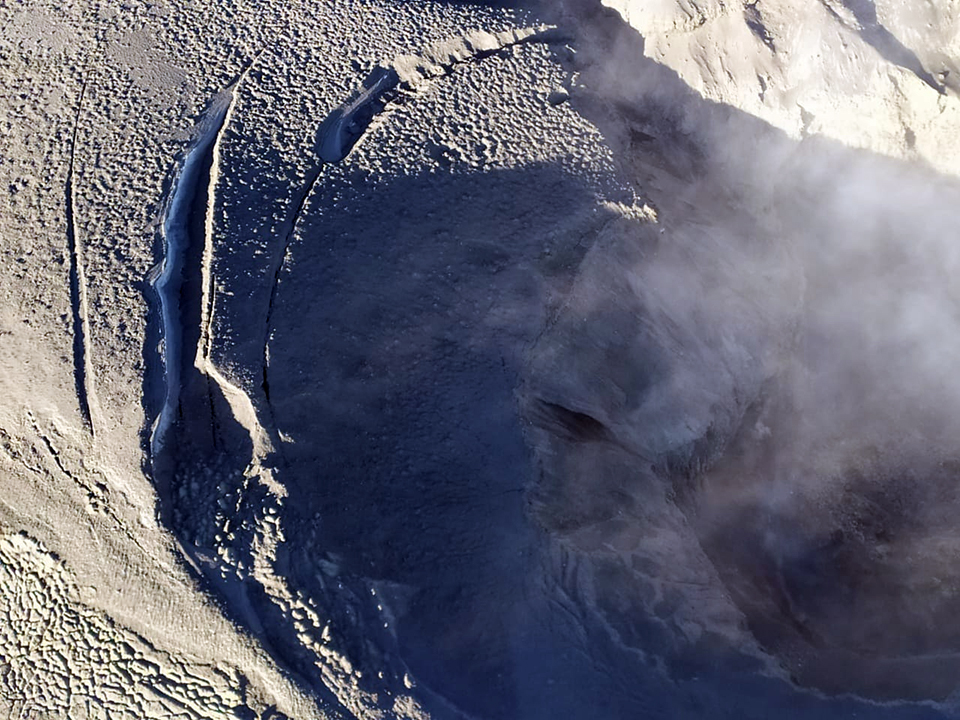 |
Figure 107. Ash covered the snow and ice field around the Arenas crater at the summit of Nevado del Ruiz on 10 January 2020. The lava dome is the dark area on the right. Courtesy of SGC (posted on Twitter @sgcol). |
The Washington VAAC reported multiple ash plumes during February 2020. On 4 February an ash plume was observed in satellite imagery drifting 35 km W from the summit at 5.8 km altitude. The following day a plume rose to 6.1 km altitude and extended 37 km W from the summit before dissipating by the end of the day (figure 108). On 6 February an ash cloud was observed in satellite imagery centered 45 km W of the summit at 5.8 km altitude. Although it had dissipated by midday, a hotspot remained in shortwave imagery until the evening. Late in the day another plume rose to 6.7 km altitude and drifted W. Diffuse ash was seen in satellite imagery on 13 February fanning towards the W at 5.8 km altitude. On 18 February at 1720 UTC the Bogota Meteorological Weather Office (MWO) reported an ash emission drifting NW at 5.8 km altitude; a second plume was reported a few hours later at the same altitude. Intermittent emissions continued the next day at 5.8-6.1 km altitude that reached as far as 50 km NW before dissipating. A plume on 21 February rose to 6.7 km altitude and drifted W (figure 109). Occasional emissions on 25 February at the same altitude reached 25 km SW of the summit before dissipating. A discrete ash emission around 1550 UTC on 26 February rose to 6.1 km altitude and drifted W. Two similar plumes were reported the next day. On 28 and 29 February plumes rose to 5.8 km altitude and drifted W.
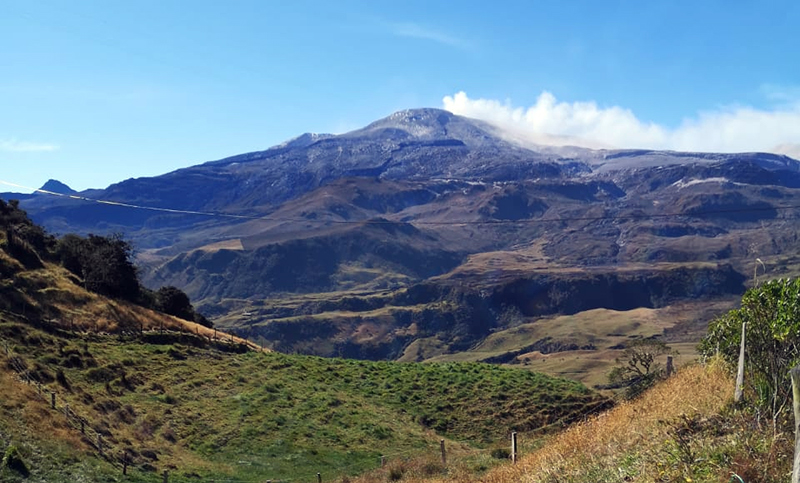 |
Figure 108. Emissions rose from the Arenas crater at Nevado del Ruiz on 5 February 2020. The Washington VAAC reported an ash plume that day that rose to 6.1 km altitude and drifted 37 km W before dissipating. Courtesy of Camilo Cupitre. |
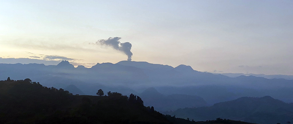 |
Figure 109. Emissions rose from the Arenas crater at Nevado del Ruiz around 0600 on 21 February 2020. The Washington VAAC reported ash emissions that day that rose to 6.7 km altitude and drifted W. Courtesy of Manuel MR. |
SGC reported several episodes of drumbeat type seismicity on 2, 8, 9, and 27 February which they attributed to effusion related to the growing lava dome in the summit crater. Sentinel-2 satellite imagery showed ring-shaped thermal anomalies characteristic of dome growth within Arenas crater several times during January and February (figure 110). The VIIRS satellite instrument recorded thermal anomalies on twelve days during February.
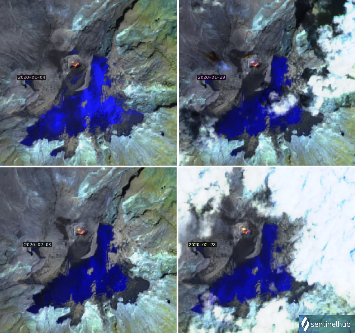 |
Figure 110. Persistent thermal anomalies from Sentinel-2 satellite imagery during January and February 2020 suggested that the lava dome inside Nevado del Ruiz’s Arenas crater was still actively growing. Atmospheric penetration rendering (bands 12, 11, 8A) courtesy of Sentinel Hub Playground. |
On 4, 14, and 19 March 2020 thermal anomalies were visible in Sentinel-2 satellite data from within the Arenas crater. Thermal anomalies were recorded by the VIIRS satellite instrument on eight days during the month. Several episodes of drumbeat seismicity were recorded during the first half of the month and on 30-31 March. Distinct SO2 plumes with DU values greater than 2 were recorded by the TROPOMI satellite instrument daily throughout February and March (figure 111). The Washington VAAC reported an ash emission on 1 March that rose to 5.8 km altitude and drifted NW; it was centered 15 km from the summit when detected in satellite imagery. The next day a plume was seen in satellite imagery moving SW at 7.0 km altitude, extending nearly 40 km from the summit. Additional ash emissions were reported on 4, 14, 15, 21, 28, 29, and 31 March; the plumes rose to 5.8-6.7 km altitude and drifted generally W, some reaching 45 km from the summit before dissipating.
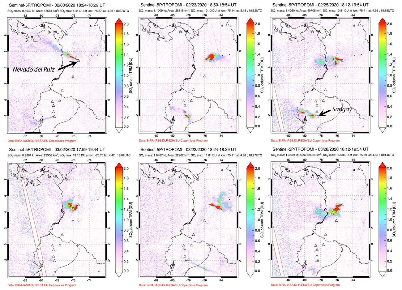 |
Figure 111. Distinct SO2 plumes with Dobson values (DU) greater than 2 were recorded by the TROPOMI satellite instrument daily during February and March 2020. Ecuador’s Sangay produced smaller but distinct plumes most of the time as well. Dates are shown at the top of each image. Courtesy of NASA’s Sulfur Dioxide Monitoring Page. |
Activity during April-June 2020. The Washington VAAC reported an ash emission that rose to 6.7 km altitude and drifted W on 1 April 2020. On 2 April, emission plumes were visible from the community of Tena in the Cundinamarca municipality which is located 100 km ESE (figure 112). The unusually clear skies were attributed to the reduction in air pollution in nearby Bogota resulting from the COVID-19 Pandemic quarantine. On 4 April the Bogota MWO reported an emission drifting SW at 5.8 km altitude. An ash plume on 8 April rose to 6.7 km altitude and drifted W. On 25 April the last reported ash plume from the Washington VAAC for the period rose to 6.1 km altitude and was observed in satellite imagery moving W at 30 km from the summit; after that, only steam and gas emissions were observed.
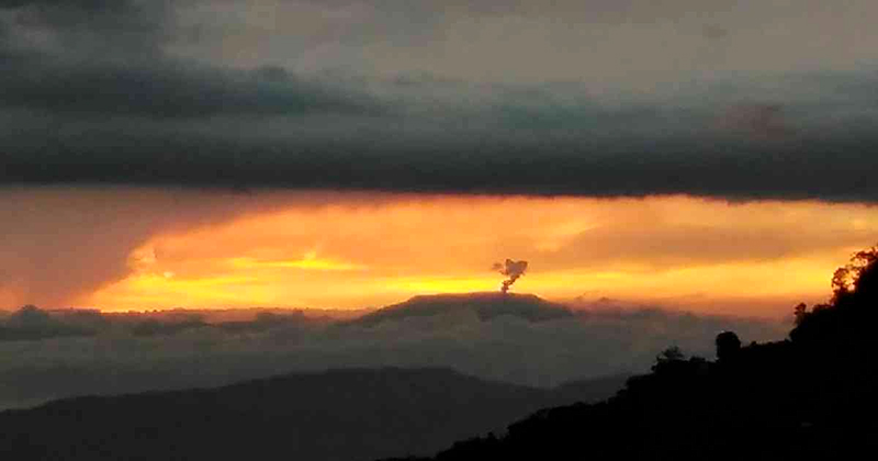 |
Figure 112. On the evening of 2 April 2020, emission plumes from Nevado del Ruiz were visible from Santa Bárbara village in Tena, Cundinamarca municipality which is located 100 km ESE. The unusually clear skies were attributed to the reduction in air pollution in the nearby city of Bogota resulting from the COVID-19 Pandemic quarantine. Photo by Williama Garcia, courtesy of Semana Sostenible (3 April 2020). |
Distinct SO2 plumes with DU values greater than 2 were recorded by the TROPOMI satellite instrument daily throughout the month. On 13 April, a Sentinel-2 thermal image showed a hot spot inside the Arenas crater largely obscured by steam and clouds. Cloudy images through May and June prevented observation of additional thermal anomalies in satellite imagery, but the VIIRS thermal data indicated anomalies on 3, 4, and 26 April. SGC reported low-energy episodes of drumbeat seismicity on 4, 9, 10, 12, 15, 16, 20, and 23 April which they interpreted as related to growth of the lava dome inside the Arenas crater. The seismic events were located 1.5-2.0 km below the floor of the crater.
Small emissions of ash and gas were reported by SGC during May 2020 and the first half of June, with the primary drift direction being NW. Gas and steam plumes rose 560-1,400 m above the summit during May and June (figure 113). Drumbeat seismicity was reported a few times each month. Sulfur dioxide emissions continued daily; increased SO2 activity was recorded during 10-13 June (figure 114).
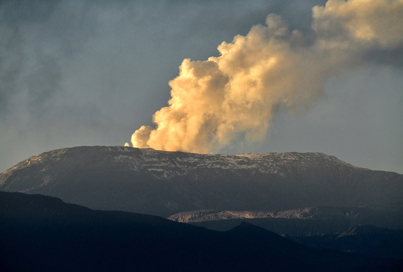 |
Figure 113. Gas and steam plumes rose 560-1,400 m above the summit of Nevado del Ruiz during May and June 2020, including in the early morning of 11 June. Courtesy of Carlos-Enrique Ruiz. |
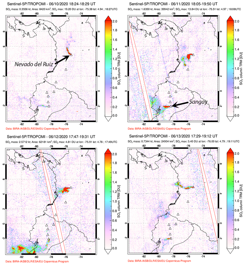 |
Figure 114. Increased SO2 activity during 10-13 June 2020 at Nevado del Ruiz was recorded by the TROPOMI instrument on the Sentinel-5P satellite. Sangay also emitted SO2 on those days. Courtesy of NASA Global Sulfur Dioxide Monitoring Page. |
Geological Summary. Nevado del Ruiz is a broad, glacier-covered volcano in central Colombia that covers more than 200 km2. Three major edifices, composed of andesitic and dacitic lavas and andesitic pyroclastics, have been constructed since the beginning of the Pleistocene. The modern cone consists of a broad cluster of lava domes built within the caldera of an older edifice. The 1-km-wide, 240-m-deep Arenas crater occupies the summit. The prominent La Olleta pyroclastic cone located on the SW flank may also have been active in historical time. Steep headwalls of massive landslides cut the flanks. Melting of its summit icecap during historical eruptions, which date back to the 16th century, has resulted in devastating lahars, including one in 1985 that was South America's deadliest eruption.
Information Contacts: El Servicio Geológico Colombiano (SGC), Diagonal 53 No. 34-53 - Bogotá D.C., Colombia (URL: https://www.sgc.gov.co/volcanes, https://twitter.com/sgcol); Global Sulfur Dioxide Monitoring Page, Atmospheric Chemistry and Dynamics Laboratory, NASA Goddard Space Flight Center (NASA/GSFC), 8800 Greenbelt Road, Goddard, Maryland, USA (URL: https://so2.gsfc.nasa.gov/); Washington Volcanic Ash Advisory Center (VAAC), Satellite Analysis Branch (SAB), NOAA/NESDIS OSPO, NOAA Science Center Room 401, 5200 Auth Rd, Camp Springs, MD 20746, USA (URL: www.ospo.noaa.gov/Products/atmosphere/vaac, archive at: http://www.ssd.noaa.gov/VAAC/archive.html); MIROVA (Middle InfraRed Observation of Volcanic Activity), a collaborative project between the Universities of Turin and Florence (Italy) supported by the Centre for Volcanic Risk of the Italian Civil Protection Department (URL: http://www.mirovaweb.it/); Hawai'i Institute of Geophysics and Planetology (HIGP) - MODVOLC Thermal Alerts System, School of Ocean and Earth Science and Technology (SOEST), Univ. of Hawai'i, 2525 Correa Road, Honolulu, HI 96822, USA (URL: http://modis.higp.hawaii.edu/); NASA Worldview (URL: https://worldview.earthdata.nasa.gov/); Sentinel Hub Playground (URL: https://www.sentinel-hub.com/explore/sentinel-playground); Camilo Cupitre (URL: https://twitter.com/Ccupitre/status/1225207439701704709); Manuel MR (URL: https://twitter.com/ElPlanetaManuel/status/1230837262088384512); Semana Sostenible (URL: https://sostenibilidad.semana.com/actualidad/articulo/fumarola-del-nevado-del-ruiz-fue-captada-desde-tena-cundinamarca/49597); Carlos-Enrique Ruiz (URL: https://twitter.com/Aleph43/status/1271800027841794049).