Report on Ol Doinyo Lengai (Tanzania) — September 2020

Bulletin of the Global Volcanism Network, vol. 45, no. 9 (September 2020)
Managing Editor: Edward Venzke.
Edited by Kadie L. Bennis.
Ol Doinyo Lengai (Tanzania) Multiple lava flows within the summit crater; September 2019-August 2020
Please cite this report as:
Global Volcanism Program, 2020. Report on Ol Doinyo Lengai (Tanzania) (Bennis, K.L., and Venzke, E., eds.). Bulletin of the Global Volcanism Network, 45:9. Smithsonian Institution. https://doi.org/10.5479/si.GVP.BGVN202009-222120
Ol Doinyo Lengai
Tanzania
2.764°S, 35.914°E; summit elev. 2962 m
All times are local (unless otherwise noted)
Ol Doinyo Lengai, located near the southern end of the East African Rift in Tanzania, is a stratovolcano known for its unique low-temperature carbonatitic lava. Frequent eruptions have been recorded since the late 19th century. Activity primarily occurs in the crater offset to the N about 100 m below the summit where hornitos (small cones) and pit craters produce lava flows and spattering. Lava began overflowing various flanks of the crater in 1993. The eruption transitioned to significant explosive activity in September 2007, which formed a new pyroclastic cone inside the crater. Repeated ash emissions reached altitudes greater than 10 km during March 2008. By mid-April 2008 explosive activity had decreased. In September new hornitos with small lava flows formed on the crater floor. The most recent eruptive period began in April 2017 and has been characterized by spattering confined to the crater, effusive activity in the summit crater, and multiple lava flows (BGVN 44:09). Effusive activity continued in the summit crater during this reporting period from September 2019 through August 2020, based on data and images from satellite information.
Throughout September 2019 to August 2020, evidence for repeated small lava flows was recorded in thermal data and satellite imagery. A total of seven low-level pulses of thermal activity were detected within 5 km from the summit in MIROVA data during September 2019 (1), February (2), March (2), and August (2) 2020 (figure 207). Sentinel-2 satellite imagery also provided evidence of multiple lava flows within the summit crater throughout the reporting period. On clear weather days, intermittent thermal anomalies were observed in thermal satellite imagery within the summit crater; new lava flows were detected due to the change in shape, volume, and location of the hotspot (figure 208). During a majority of the reporting period, the thermal anomaly dominantly appeared in the center of the crater, though occasionally it would also migrate to the SE wall, as seen on 3 February, the E wall on 12 July, or the NE wall on 31 August. In Natural Color rendering, fresh lava flows appear black within the crater that quickly cools to a white-brown color. These satellite images showed the migration of new lava flows between February, March, and June (figure 209). The flow on 8 February occurs in the center and along the W wall of the crater; the flow on 9 March is slightly thinner and is observed in the center and along the E wall of the crater; finally, the flow on 17 June is located in the center and along the N wall of the crater.
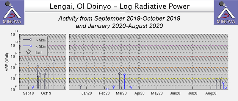 |
Figure 207. Seven low-level pulses of thermal activity within 5 km of the summit of Ol Doinyo Lengai were recorded in the MIROVA thermal data between September 2019 to August 2020; one in early September 2019, two in February, two in March, and two in August 2020. Courtesy of MIROVA. |
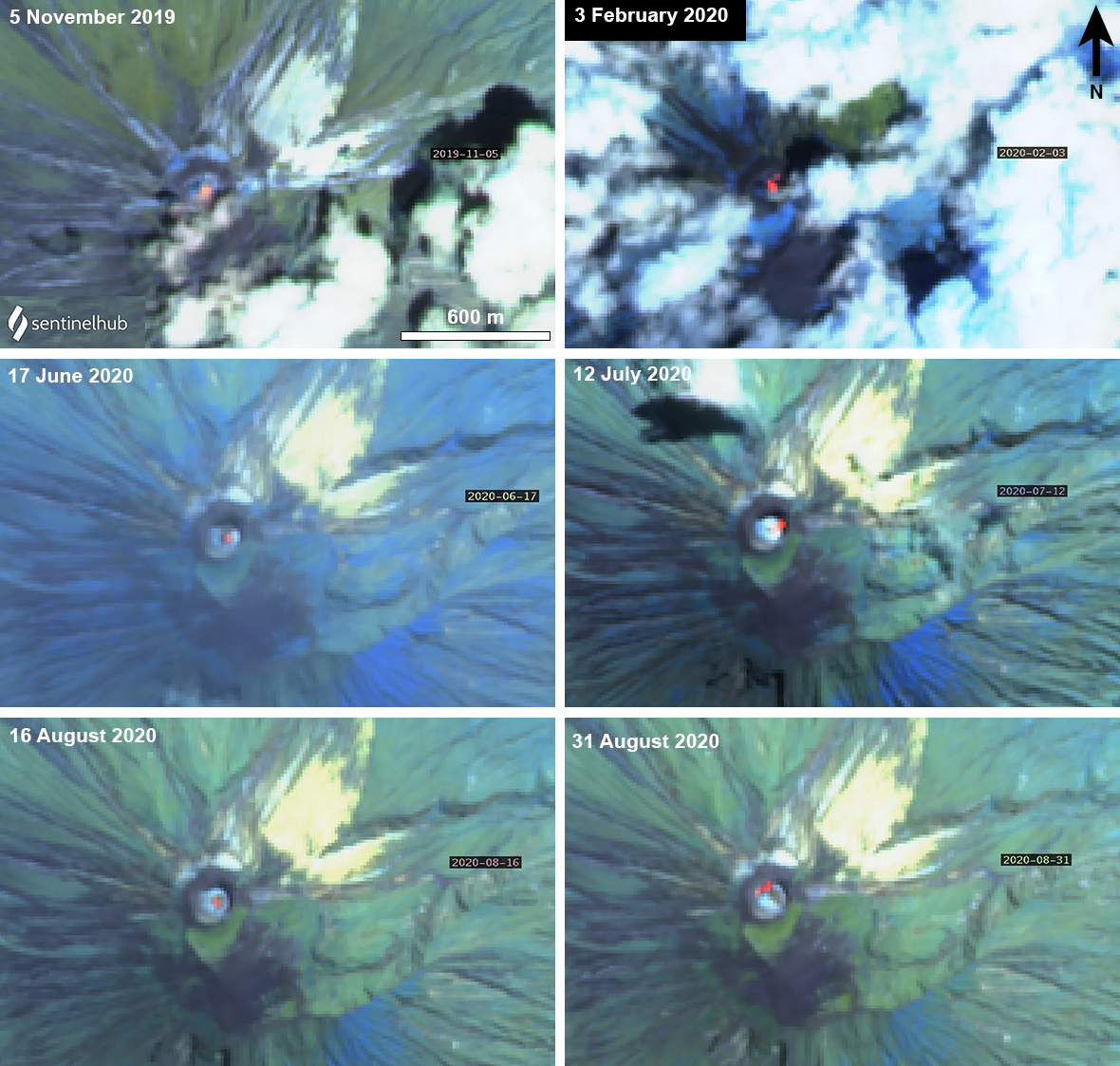 |
Figure 208. Sentinel-2 thermal satellite images of Ol Doinyo Lengai from November 2019 to August 2020 show intermittent thermal anomalies (bright yellow-orange) within the summit crater. The location of these anomalies occasionally changes, indicating new lava flows. Images with “Atmospheric penetration” (bands 12, 11, 8A) rendering; courtesy of Sentinel Hub Playground. |
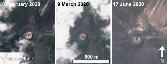 |
Figure 209. Sentinel-2 satellite images of new lava flows within the summit crater at Ol Doinyo Lengai during 8 February (left), 9 March (middle), and 17 June (right) 2020. Lava flows appear black in the center of the crater that changes in volume and location from February to June. Images with “Natural Color” (bands 4, 3, 2) rendering; courtesy of Sentinel Hub Playground. |
During August, multiple lava flows were detected in Sentinel-2 satellite imagery. On relatively clear days, lava flows were visible in the middle of the summit crater, occasionally branching out to one side of the crater (figure 210). On 6 August, a thin lava flow branched to the E flank, which became thicker by 11 August. On 16 and 21 August, the lava remained mostly in the center of the crater. A large pulse of fresh lava occurred on 31 August, extending to the NW and SE sides of the crater.
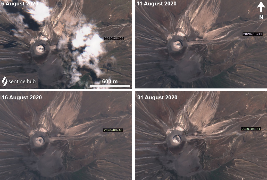 |
Figure 210. Sentinel-2 images of multiple new lava flows at Ol Doinyo Lengai during August 2020. When visible in the first half of August, dark lava is concentrated in the center and E side of the crater; by the end of August the lava flows had reached the NW side of the crater. Images with “Natural Color” (bands 4, 3, 2) rendering; courtesy of Sentinel Hub Playground. |
Geological Summary. The symmetrical Ol Doinyo Lengai is the only volcano known to have erupted carbonatite tephras and lavas in historical time. The prominent stratovolcano, known to the Maasai as "The Mountain of God," rises abruptly above the broad plain south of Lake Natron in the Gregory Rift Valley. The cone-building stage ended about 15,000 years ago and was followed by periodic ejection of natrocarbonatitic and nephelinite tephra during the Holocene. Historical eruptions have consisted of smaller tephra ejections and emission of numerous natrocarbonatitic lava flows on the floor of the summit crater and occasionally down the upper flanks. The depth and morphology of the northern crater have changed dramatically during the course of historical eruptions, ranging from steep crater walls about 200 m deep in the mid-20th century to shallow platforms mostly filling the crater. Long-term lava effusion in the summit crater beginning in 1983 had by the turn of the century mostly filled the northern crater; by late 1998 lava had begun overflowing the crater rim.
Information Contacts: MIROVA (Middle InfraRed Observation of Volcanic Activity), a collaborative project between the Universities of Turin and Florence (Italy) supported by the Centre for Volcanic Risk of the Italian Civil Protection Department (URL: http://www.mirovaweb.it/); Sentinel Hub Playground (URL: https://www.sentinel-hub.com/explore/sentinel-playground).