Report on Krakatau (Indonesia) — October 2020

Bulletin of the Global Volcanism Network, vol. 45, no. 10 (October 2020)
Managing Editor: Edward Venzke.
Edited by Kadie L. Bennis.
Krakatau (Indonesia) Eruption ends in mid-April 2020, but intermittent thermal anomalies continue
Please cite this report as:
Global Volcanism Program, 2020. Report on Krakatau (Indonesia) (Bennis, K.L., and Venzke, E., eds.). Bulletin of the Global Volcanism Network, 45:10. Smithsonian Institution. https://doi.org/10.5479/si.GVP.BGVN202010-262000
Krakatau
Indonesia
6.1009°S, 105.4233°E; summit elev. 285 m
All times are local (unless otherwise noted)
Krakatau, located in the Sunda Strait between Indonesia’s Java and Sumatra Islands, experienced a major caldera collapse around 535 CE, forming a 7-km-wide caldera ringed by three islands. Presently, the caldera is underwater, except for three surrounding islands (Verlaten, Lang, and Rakata) and the active Anak Krakatau that was constructed within the 1883 caldera and has been the site of frequent eruptions since 1927. On 22 December 2018, a large explosion and flank collapse destroyed most of the 338-m-high island of Anak Krakatau (Child of Krakatau) and generated a deadly tsunami (BGVN 44:03). A larger explosion in December 2019 produced the beginnings of a new cone above the surface of crater lake (BGVN 45:02). The previous report (BGVN 45:06) described activity that included Strombolian explosions, ash plumes, and crater incandescence. This report updates information from June through September 2020 using information primarily from Indonesian Center for Volcanology and Geological Hazard Mitigation, also known as Pusat Vulkanologi dan Mitigasi Bencana Geologi (PVMBG) and satellite data.
A VONA notice from PVMBG reported that the last eruptive event at Krakatau was reported on 17 April 2020, though the eruptive column was not observed. Activity after that was relatively low through September 2020, primarily intermittent diffuse white gas-and-steam emissions, according to PVMBG. No activity was reported during June-August, except for minor seismicity. During 11-13, 16, and 18 September, the CCTV Lava93 webcam showed intermittent white gas-and-steam emissions rising 25-50 m above the crater.
The MIROVA (Middle InfraRed Observation of Volcanic Activity) graph of MODIS thermal anomaly data showed intermittent hotspots within 5 km of the crater from May through September (figure 113). Some of these thermal hotspots were also detected in Suomi NPP/VIIRS sensor data. Sentinel-2 thermal satellite imagery showed faint thermal anomalies in the crater during June; no thermal activity was detected after June (figure 114).
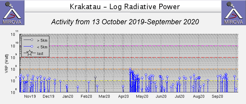 |
Figure 113. Intermittent thermal activity at Anak Krakatau from 13 October 2019-September 2020 shown on a MIROVA Low Radiative Power graph. The power of the thermal anomalies decreased after activity in April but continued intermittently through September. Courtesy of MIROVA. |
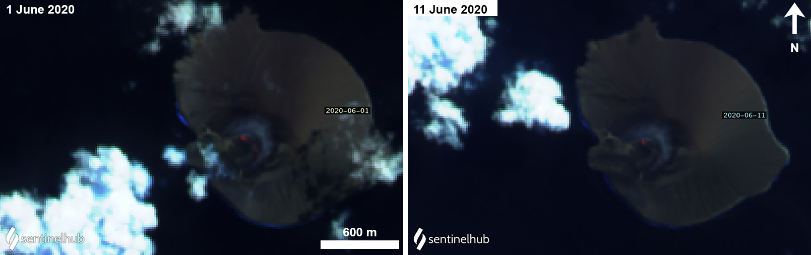 |
Figure 114. Sentinel-2 thermal satellite images showing a faint thermal anomaly in the crater during 1 (left) and 11 (right) June 2020. Sentinel-2 satellite images with “Atmospheric penetration” (bands 12, 11, 8A) rendering; courtesy of Sentinel Hub Playground. |
Geological Summary. The renowned Krakatau (frequently mis-named as Krakatoa) volcano lies in the Sunda Strait between Java and Sumatra. Collapse of an older edifice, perhaps in 416 or 535 CE, formed a 7-km-wide caldera. Remnants of that volcano are preserved in Verlaten and Lang Islands; subsequently the Rakata, Danan, and Perbuwatan cones were formed, coalescing to create the pre-1883 Krakatau Island. Caldera collapse during the catastrophic 1883 eruption destroyed Danan and Perbuwatan, and left only a remnant of Rakata. This eruption caused more than 36,000 fatalities, most as a result of tsunamis that swept the adjacent coastlines of Sumatra and Java. Pyroclastic surges traveled 40 km across the Sunda Strait and reached the Sumatra coast. After a quiescence of less than a half century, the post-collapse cone of Anak Krakatau (Child of Krakatau) was constructed within the 1883 caldera at a point between the former Danan and Perbuwatan cones. Anak Krakatau has been the site of frequent eruptions since 1927.
Information Contacts: Pusat Vulkanologi dan Mitigasi Bencana Geologi (PVMBG, also known as Indonesian Center for Volcanology and Geological Hazard Mitigation, CVGHM), Jalan Diponegoro 57, Bandung 40122, Indonesia (URL: http://www.vsi.esdm.go.id/); MIROVA (Middle InfraRed Observation of Volcanic Activity), a collaborative project between the Universities of Turin and Florence (Italy) supported by the Centre for Volcanic Risk of the Italian Civil Protection Department (URL: http://www.mirovaweb.it/); Sentinel Hub Playground (URL: https://www.sentinel-hub.com/explore/sentinel-playground); NASA Worldview (URL: https://worldview.earthdata.nasa.gov/).