Report on Merapi (Indonesia) — October 2020

Bulletin of the Global Volcanism Network, vol. 45, no. 10 (October 2020)
Managing Editor: Edward Venzke.
Edited by Kadie L. Bennis.
Merapi (Indonesia) Eruptions in April and June 2020 produced ash plumes and ashfall
Please cite this report as:
Global Volcanism Program, 2020. Report on Merapi (Indonesia) (Bennis, K.L., and Venzke, E., eds.). Bulletin of the Global Volcanism Network, 45:10. Smithsonian Institution. https://doi.org/10.5479/si.GVP.BGVN202010-263250
Merapi
Indonesia
7.54°S, 110.446°E; summit elev. 2910 m
All times are local (unless otherwise noted)
Merapi, located just north of the city of Yogyakarta, Indonesia, is a highly active stratovolcano; the current eruption began in May 2018. Volcanism has recently been characterized by lava dome growth and collapse, small block-and-ash flows, explosions, ash plumes, ashfall, and pyroclastic flows (BGVN 44:10 and 45:04). Activity has recently consisted of three large eruptions in April and June, producing dense gray ash plumes and ashfall in June. Dominantly, white gas-and-steam emissions have been reported during April-September 2020. The primary reporting source of activity comes from Balai Penyelidikan dan Pengembangan Teknologi Kebencanaan Geologi (BPPTKG, the Center for Research and Development of Geological Disaster Technology, a branch of PVMBG), the Pusat Vulkanologi dan Mitigasi Bencana Geologi (PVMBG, also known as Indonesian Center for Volcanology and Geological Hazard Mitigation, CVGHM), and the Darwin Volcanic Ash Advisory Centre (VAAC).
Activity at Merapi dominantly consisted of frequent white gas-and-steam emissions that generally rose 20-600 m above the crater (figure 95). On 2 April an eruption occurred at 1510, producing a gray ash plume that rose 3 km above the crater, and accompanied by white gas-and-steam emissions up to 600 m above the crater. A second explosion on 10 April at 0910 generated a gray ash plume rising 3 km above the crater and drifting NW, accompanied by white gas-and-steam emissions rising 300 m above the crater (figure 96). Activity over the next six weeks consisted primarily of gas-and-steam emissions.
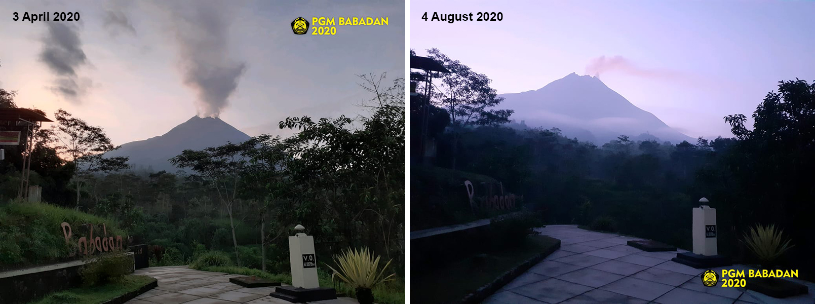 |
Figure 95. Gas-and-steam emissions were frequently observed rising from Merapi as seen on 3 April (left) and 4 August (right) 2020. Courtesy of BPPTKG. |
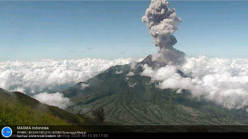 |
Figure 96. Webcam image showed an ash plume rising 3 km above the crater of Merapi at 0917 on 10 April 2020. Courtesy of BPPTKG and MAGMA Indonesia. |
On 8 June PVMBG reported an increase in seismicity. Aerial photos from 13 June taken using drones were used to measure the lava dome, which had decreased in volume to 200,000 m3, compared to measurements from 19 February 2020 (291,000 m3). On 21 June two explosions were recorded at 0913 and 0927; the first explosion lasted less than six minutes while the second was less than two minutes. A dense, gray ash plume reached 6 km above the crater drifting S, W, and SW according to the Darwin VAAC notice and CCTV station (figure 97), which resulted in ashfall in the districts of Magelang, Kulonprogo, and as far as the Girimulyo District (45 km). During 21-22 June the gas-and-steam emissions rose to a maximum height of 6 km above the crater. The morphology of the summit crater had slightly changed by 22 June. Based on photos from the Ngepos Post, about 19,000 m3 of material had been removed from the SW part of the summit, likely near or as part of the crater rim. On 11 and 26 July new measurements of the lava dome were taken, measuring 200,000 m3 on both days, based on aerial photos using drones. Gas-and-steam emissions continued through September.
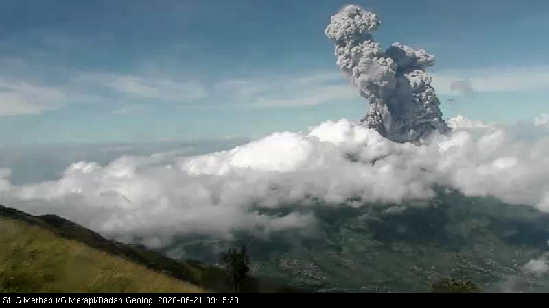 |
Figure 97. Webcam image showed an ash plume rising 6 km above the crater of Merapi at 0915 on 21 June 2020. Courtesy of BPPTKG. |
Geological Summary. Merapi, one of Indonesia's most active volcanoes, lies in one of the world's most densely populated areas and dominates the landscape immediately north of the major city of Yogyakarta. It is the youngest and southernmost of a volcanic chain extending NNW to Ungaran volcano. Growth of Old Merapi during the Pleistocene ended with major edifice collapse perhaps about 2,000 years ago, leaving a large arcuate scarp cutting the eroded older Batulawang volcano. Subsequent growth of the steep-sided Young Merapi edifice, its upper part unvegetated due to frequent activity, began SW of the earlier collapse scarp. Pyroclastic flows and lahars accompanying growth and collapse of the steep-sided active summit lava dome have devastated cultivated lands on the western-to-southern flanks and caused many fatalities.
Information Contacts: Balai Penyelidikan dan Pengembangan Teknologi Kebencanaan Geologi (BPPTKG), Center for Research and Development of Geological Disaster Technology (URL: http://merapi.bgl.esdm.go.id/, Twitter: @BPPTKG); Pusat Vulkanologi dan Mitigasi Bencana Geologi (PVMBG, also known as Indonesian Center for Volcanology and Geological Hazard Mitigation, CVGHM), Jalan Diponegoro 57, Bandung 40122, Indonesia (URL: http://www.vsi.esdm.go.id/); MAGMA Indonesia, Kementerian Energi dan Sumber Daya Mineral (URL: https://magma.vsi.esdm.go.id/); Darwin Volcanic Ash Advisory Centre (VAAC), Bureau of Meteorology, Northern Territory Regional Office, PO Box 40050, Casuarina, NT 0811, Australia (URL: http://www.bom.gov.au/info/vaac/).