Report on Bagana (Papua New Guinea) — January 2021

Bulletin of the Global Volcanism Network, vol. 46, no. 1 (January 2021)
Managing Editor: Edward Venzke.
Edited by Kadie L. Bennis.
Bagana (Papua New Guinea) Ongoing thermal anomalies possibly indicating lava flows during May-December 2020
Please cite this report as:
Global Volcanism Program, 2021. Report on Bagana (Papua New Guinea) (Bennis, K.L., and Venzke, E., eds.). Bulletin of the Global Volcanism Network, 46:1. Smithsonian Institution. https://doi.org/10.5479/si.GVP.BGVN202101-255020
Bagana
Papua New Guinea
6.137°S, 155.196°E; summit elev. 1855 m
All times are local (unless otherwise noted)
Bagana is a remote volcano located in central Bougainville Island in Papua New Guinea with eruptions dating back to 1842. The current eruption period began in February 2000, with more recent activity characterized by thermal anomalies along with gas-and-steam and ash plumes (BGVN 44:12 and 45:07). Typical activity consists of episodes of lava flows and intermittent strong passive degassing, especially sulfur dioxide. This report covers activity from May-December 2020 using primarily thermal data and satellite imagery.
MIROVA (Middle InfraRed Observation of Volcanic Activity) analysis of MODIS satellite data showed a cluster of intermittent low-power thermal anomalies during June through early August, followed by a period of quiescence during August to mid-October, with the exception of two anomalies detected in early September (figure 36). Thermal activity slightly increased again by mid-October and continued infrequently through December at low levels. This pattern of thermal activity is also reflected in three Sentinel-2 thermal satellite images that showed faint, roughly linear, thermal anomalies, indicative of lava flows trending NE and NW on 21 June, NE on 1 July, and W on 23 November (figure 37). On clear weather days, gas-and-steam emissions could be seen in satellite imagery on 30 August, 4 October, and 23 November, each of which drifted W (figure 37). Gas-and-steam emissions on 13 December drifted E.
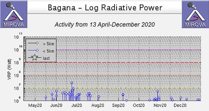 |
Figure 36. Intermittent low-power thermal anomalies were detected at Bagana during late May-December 2020 as recorded by the MIROVA system (Log Radiative Power). Relatively higher power and frequency anomalies were detected during June-early August. Thermal activity declined after early August into mid-October, with the exception of two thermal anomalies in early September. Activity increased again slightly by mid-October and continued through December, but at a lower power and frequency. Courtesy of MIROVA. |
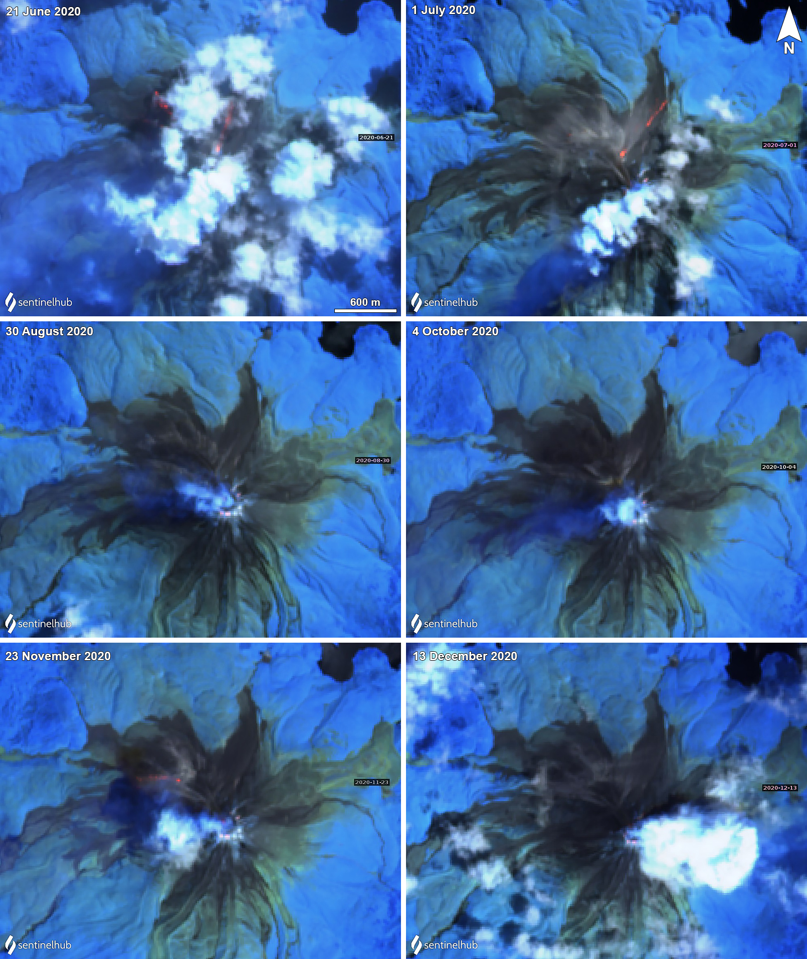 |
Figure 37. Sentinel-2 thermal satellite imagery showing weak thermal anomalies at Bagana during June through December 2020. Top left: Faint, linear thermal anomalies on 21 June 2020 on the NE and NW flanks, which could represent lava effusion, though clouds covered much of the area. Top right: Hot material traveling down the NE flank on 1 July 2020. Middle left and right: Gas-and-steam emissions rising from the summit crater and drifting W on 30 August and 4 October 2020; very faint thermal anomalies can be observed in the crater. Bottom left: Gas-and-steam emissions in the summit crater drifted W on 23 November 2020, and a probable lava flow is visible extending down the NW flank. Bottom right: Gas-and-steam emissions rose above the summit crater on 13 December 2020 and drifted E. Sentinel-2 images with "Atmospheric penetration" (bands 12, 11, 8A) rendering. Courtesy of Sentinel Hub Playground. |
Geological Summary. Bagana volcano, in a remote portion of central Bougainville Island, is frequently active. This massive symmetrical cone was largely constructed by an accumulation of viscous andesitic lava flows. The entire edifice could have been constructed in about 300 years at its present rate of lava production. Eruptive activity is characterized by non-explosive effusion of viscous lava that maintains a small lava dome in the summit crater, although occasional explosive activity produces pyroclastic flows. Lava flows with tongue-shaped lobes up to 50 m thick and prominent levees descend the flanks on all sides.
Information Contacts: MIROVA (Middle InfraRed Observation of Volcanic Activity), a collaborative project between the Universities of Turin and Florence (Italy) supported by the Centre for Volcanic Risk of the Italian Civil Protection Department (URL: http://www.mirovaweb.it/); Sentinel Hub Playground (URL: https://www.sentinel-hub.com/explore/sentinel-playground).