Report on Ibu (Indonesia) — January 2021

Bulletin of the Global Volcanism Network, vol. 46, no. 1 (January 2021)
Managing Editor: Edward Venzke.
Edited by A. Elizabeth Crafford.
Ibu (Indonesia) Persistent daily ash emissions and thermal anomalies, July-December 2020
Please cite this report as:
Global Volcanism Program, 2021. Report on Ibu (Indonesia) (Crafford, A.E., and Venzke, E., eds.). Bulletin of the Global Volcanism Network, 46:1. Smithsonian Institution. https://doi.org/10.5479/si.GVP.BGVN202101-268030
Ibu
Indonesia
1.488°N, 127.63°E; summit elev. 1325 m
All times are local (unless otherwise noted)
Mount Ibu is an active stratovolcano located along the NW coast of Halmahera Island in Indonesia. After a two-day eruption in 1911, Ibu was quiet until 1998-1999 when explosions produced ash emissions, a lava flow and dome growth began inside the summit crater. Although possible dome growth occurred in 2001 and 2004, little activity was reported until ash emissions began in April 2008. These were followed by thermal anomalies beginning the next month; ash emissions and dome growth have continued for 12 years and the dome now fills the summit crater (BGVN 45:07). Activity continued throughout 2020, consisting of frequent white-and-gray emissions, ash explosions, ash plumes, and small lava flows. This report updates activity through December 2020, using data from the Pusat Vulkanologi dan Mitigasi Bencana Geologi (PVMBG, also known as Indonesian Center for Volcanology and Geological Hazard Mitigation, CVGHM), Darwin Volcanic Ash Advisory Centre (VAAC), and various satellite instruments.
Activity throughout July-December 2020 was very consistent and similar to activity reported earlier in the year. Tens of daily explosions produced white and gray ash emissions that rose 200-800 m above the summit (figure 25). Occasional larger explosions were reported in VONAs and VAAC notices. The MIROVA graph of log radiative power for the period shows consistent thermal anomalies the entire time (figure 26). Satellite imagery from Sentinel-2 identified thermal anomalies inside the summit crater every month, usually a larger central one and a smaller one to the NW, suggesting continued dome growth and lava flow activity (figure 27).
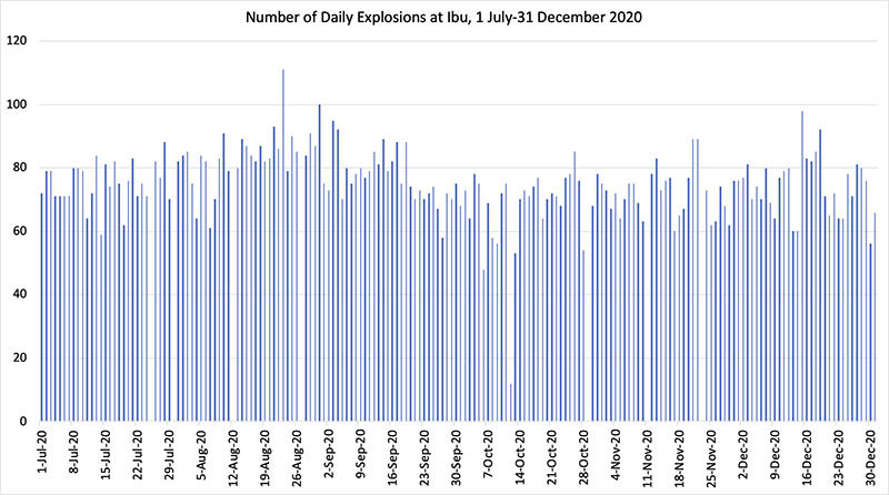 |
Figure 25. Between 60 and 90 explosions occurred most days at Ibu during 1 July-31 December 2020. White and gray plumes rose 200-800 m above the summit crater every day. Data courtesy of PVMBG daily reports. |
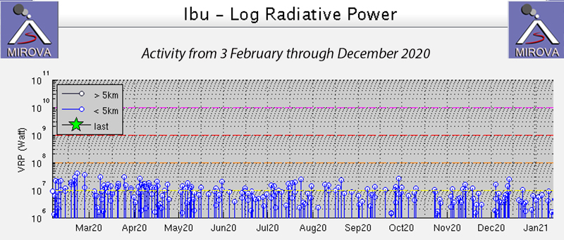 |
Figure 26. The MIROVA graph of Log Radiative Power at Ibu from 3 February through December 2020 indicated a constant ongoing heat source from the summit of the crater. Courtesy of MIROVA. |
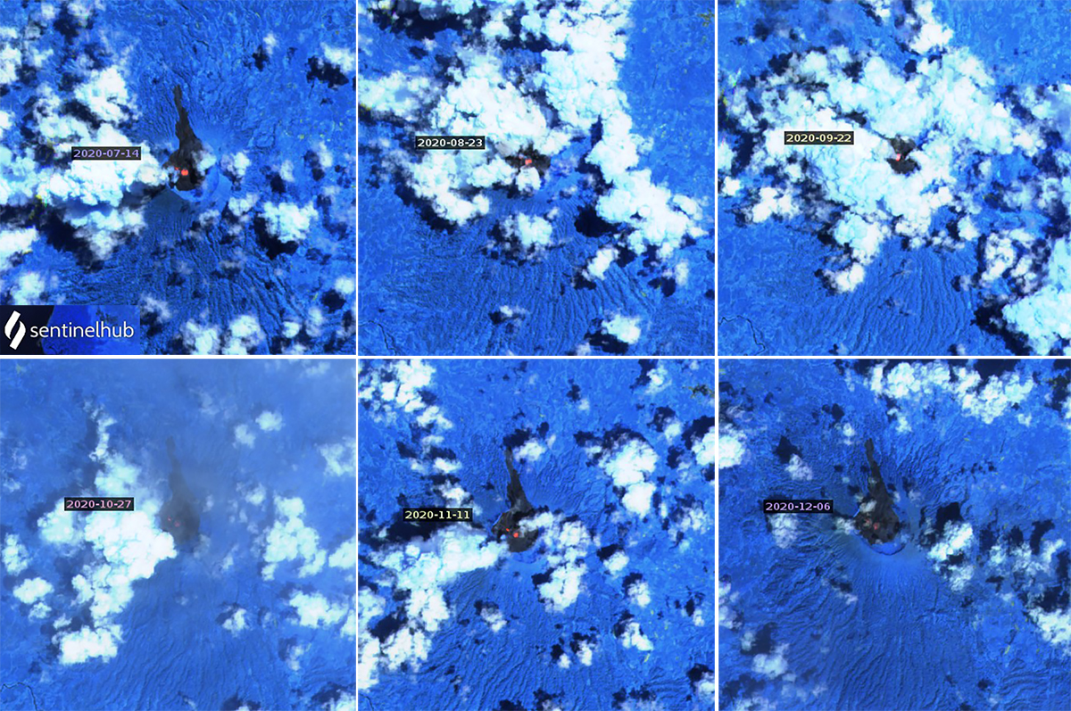 |
Figure 27. Thermal anomalies persisted at the summit of Ibu throughout July-December 2020. One central anomaly was usual accompanied by a smaller one slightly NW of the central spot. Atmospheric penetration rendering (bands 12, 11a, and 8), courtesy of Sentinel Hub Playground. |
The Darwin VAAC observed multiple minor ash emissions in satellite imagery drifting W on 6 July 2020 at 1.8 km altitude. A series of discrete puffs of ash were observed on 15 July also at 1.8 km altitude drifting W. Ongoing minor emissions were discernible on visible and RGB imagery at 2.1 km altitude drifting W on 20 July. On 30 July ash plumes rose to 1.8 km altitude drifted NW and a hotspot was present at the summit. A single MODVOLC alert was issued on 8 July. Single MODVOLC alerts were also issued on 11, 18, and 27 August 2020. PVMBG issued a VONA on 5 August, reporting an ash cloud that rose to 1.8 km altitude and drifted N (figure 28). The Darwin VAAC reported an ash emission later that day that rose to 4.3 km altitude and drifted NW for several hours before dissipating. Multiple discrete emissions were identified in satellite imagery drifting N at 2.1 km altitude on 11 August; they dissipated quickly. During 22-25 August intermittent ash emissions rose to 1.5-1.8 km altitude and drifted NW and W. Minor continuous emissions were again reported on 28 August.
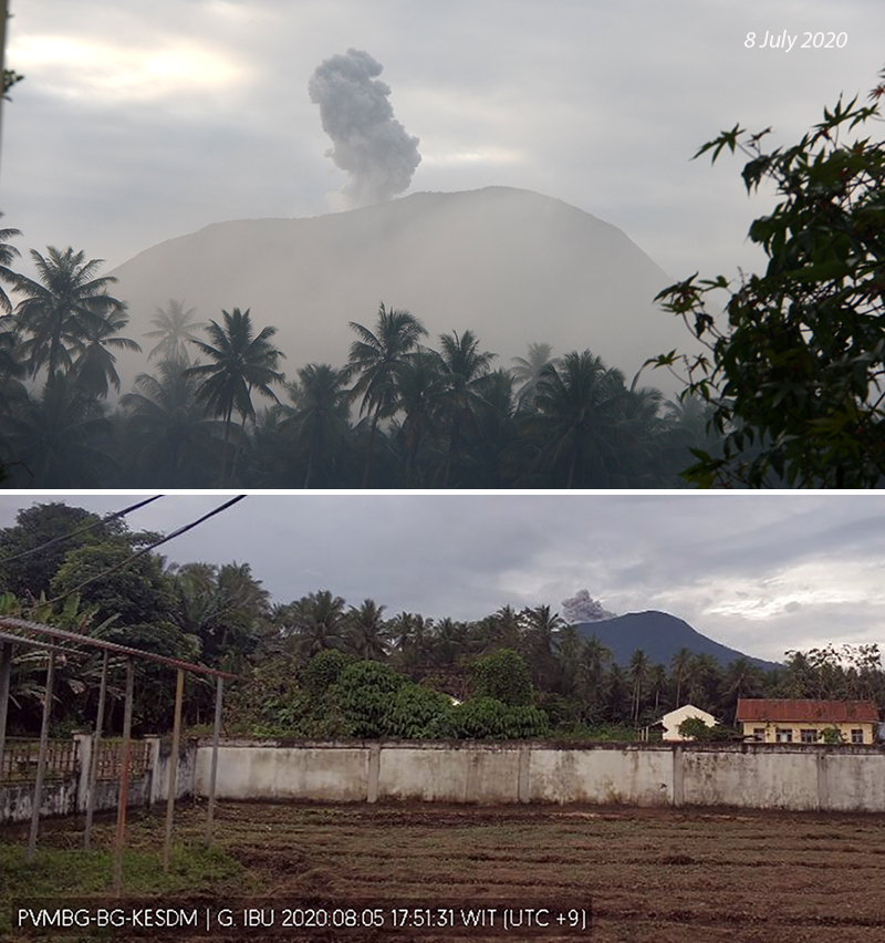 |
Figure 28. Ash plumes rose from the summit of Ibu many days during July and August 2020, including on 8 July (top) and 5 August (bottom). Courtesy of PVMBG. |
Many ash emissions during September and October 2020 were not accompanied by VONAs or VAAC advisories (figure 29). PVMBG issued a VONA on 20 September for an ash emission that rose to 1.5 km altitude and drifted N. Continuous discrete ash emissions over several days drifted SW to NW during 25-29 September at 1.8-2.1 km altitude, as reported in multiple VONAs and VAAC advisories. Single MODVOLC alerts were issued on 26 and 30 September. The Darwin VAAC issued an ash advisory on 8 October for intermittent ash emissions rising to 2.1 km altitude and drifting NW. A single MODVOLC alert was issued the next day. On 20 October ash emissions again rose to 2.1 km altitude and drifted NE.
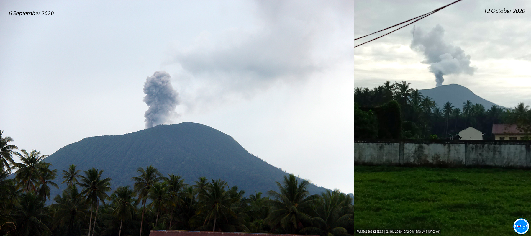 |
Figure 29. Ash emissions at Ibu were photographed in webcams on 6 September (left) and 12 October (right) 2020. Courtesy of PVMBG. |
The Darwin VAAC reported intermittent ash emissions to 1.8 km altitude during 3-5, 12-13, 18-19, and 22 November 2020 that drifted SSW for several hours before dissipating. PVMBG also issued a VONA for an ash cloud on 27 November that rose to 2.1 km altitude and drifted W. They reported faint rumbling at the PGA Ibu station on 10 November and loud rumbling on 16 and 18 November. During December, minor ash emissions rose to 1.8-2.1 km altitude and drifted E on 4 and 6 December, SW on 11 December, and SE on 12-13 December. PVMBG issued a VONA on 19 December for a white to gray ash cloud drifting N at 1.7 km altitude. Single MODVOLC alerts were issued on 10, 13, and 22 December. Numerous ash emissions were captured by the webcams (figure 30).
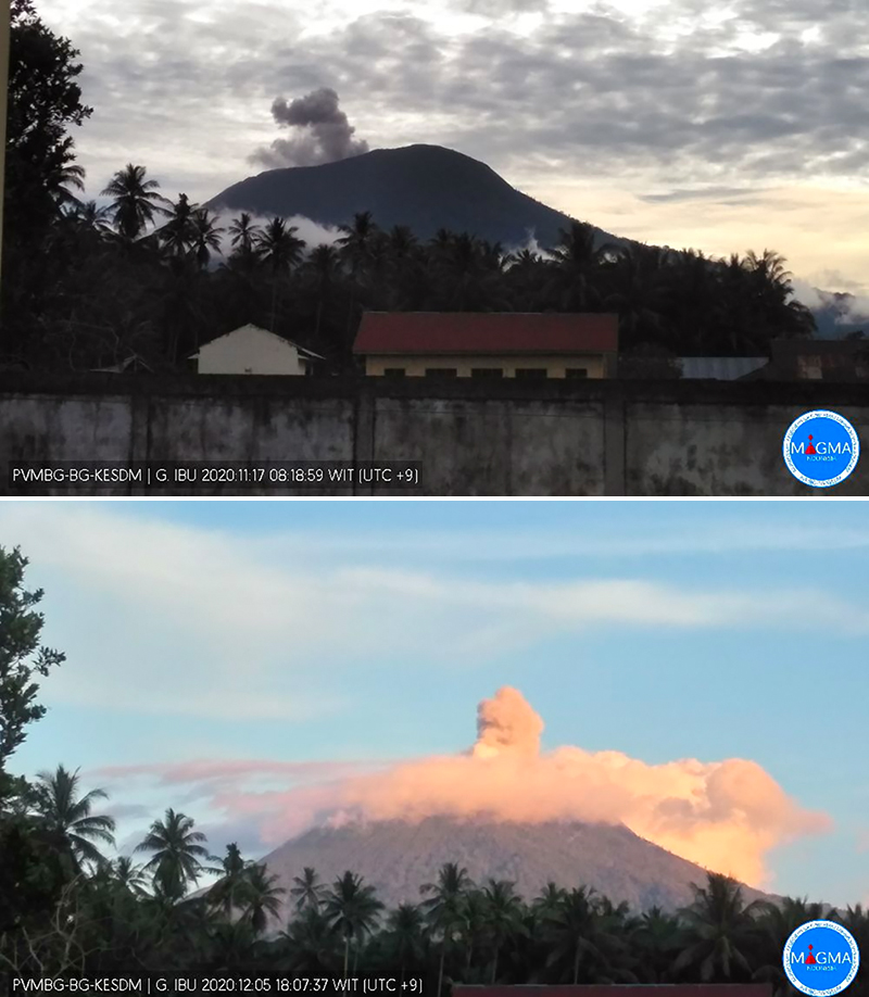 |
Figure 30. Ash emissions at Ibu were recorded in webcams on 17 November (top) and 5 December (bottom) 2020. Courtesy of PVMBG. |
Geological Summary. The truncated summit of Gunung Ibu stratovolcano along the NW coast of Halmahera Island has large nested summit craters. The inner crater, 1 km wide and 400 m deep, has contained several small crater lakes. The 1.2-km-wide outer crater is breached on the N, creating a steep-walled valley. A large cone grew ENE of the summit, and a smaller one to the WSW has fed a lava flow down the W flank. A group of maars is located below the N and W flanks. The first observed and recorded eruption was a small explosion from the summit crater in 1911. Eruptive activity began again in December 1998, producing a lava dome that eventually covered much of the floor of the inner summit crater along with ongoing explosive ash emissions.
Information Contacts: Pusat Vulkanologi dan Mitigasi Bencana Geologi (PVMBG, also known as Indonesian Center for Volcanology and Geological Hazard Mitigation, CVGHM), Jalan Diponegoro 57, Bandung 40122, Indonesia (URL: http://www.vsi.esdm.go.id/); Darwin Volcanic Ash Advisory Centre (VAAC), Bureau of Meteorology, Northern Territory Regional Office, PO Box 40050, Casuarina, NT 0811, Australia (URL: http://www.bom.gov.au/info/vaac/); Hawai'i Institute of Geophysics and Planetology (HIGP) - MODVOLC Thermal Alerts System, School of Ocean and Earth Science and Technology (SOEST), Univ. of Hawai'i, 2525 Correa Road, Honolulu, HI 96822, USA (URL: http://modis.higp.hawaii.edu/); MIROVA (Middle InfraRed Observation of Volcanic Activity), a collaborative project between the Universities of Turin and Florence (Italy) supported by the Centre for Volcanic Risk of the Italian Civil Protection Department (URL: http://www.mirovaweb.it/); Sentinel Hub Playground (URL: https://www.sentinel-hub.com/explore/sentinel-playground).