Pacaya
Guatemala
14.382°N, 90.601°W; summit elev. 2569 m
All times are local (unless otherwise noted)
Extensive lava flows, bomb-laden Strombolian explosions, and ash plumes emerging from Mackenney crater have characterized the persistent activity at Pacaya since 1961. The latest eruptive episode began with intermittent ash plumes and incandescence in June 2015; the growth of a new pyroclastic cone inside the summit crater was confirmed later that year. The cone has continued to grow, producing frequent loud Strombolian explosions rising above the crater rim and ongoing ash emissions. In addition, fissures on the flanks of the summit crater have been the source of an increasing number of lava flows traveling distances of over one kilometer down multiple flanks during 2019 and into 2021. Increasing explosive and effusive activity during December 2020-February 2021 is covered in this report with information provided by Guatemala's Instituto Nacional de Sismologia, Vulcanologia, Meteorologia e Hydrologia (INSIVUMEH), multiple sources of satellite data, and numerous photographs from observers on the ground.
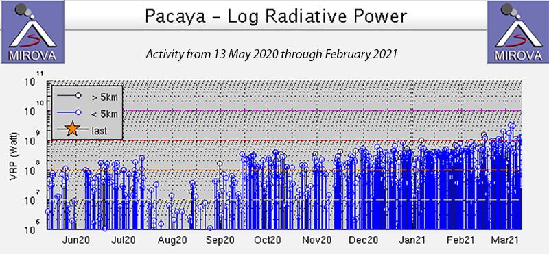
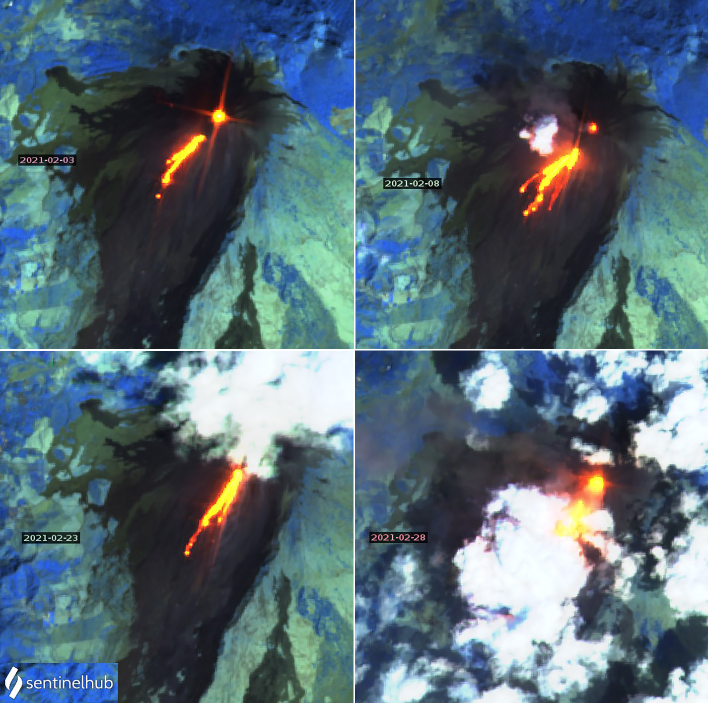
Eruptive activity increased substantially during December 2020-February 2021. During December, ash emissions were reported fewer than half the days of the month; by February, dense ash emissions drifted many kilometers most days, and ashfall was reported numerous times in the surrounding communities. Strombolian explosions in December generally rose 50-125 m above the summit of the pyroclastic cone; by February they were commonly rising 300 m or more and sending ejecta 500 m from the summit. Numerous lava flows were reported on the NW, W, and S flanks during the period; a flow that emerged on the SSW flank on 7 January 2021 persisted through the end of February and was 800-1,200 m long. Strombolian activity also occurred at the fissure where the flow emerged, and incandescent blocks rolled hundreds of meters beyond the front of the flow. A steady increase in thermal activity was recorded with the MIROVA Log Radiative Power graph during December 2020 – February 2021 (figure 145). This corresponded to the persistent lava flows on multiple flanks and constant Strombolian activity. Multiple MODVOLC thermal alerts were issued many days each month during the period.
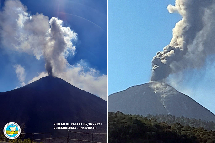
The Washington VAAC reported an ash emission at Pacaya that rose to 3.0 km altitude and drifted WSW on 3 December 2020; it dissipated within a few hours. INSIVUMEH reported daily gas and steam plumes that rose a few hundred meters and sometimes drifted as far as 10 km. They also reported ash emissions along with the gas and steam on 10, 12-14, 16-18, 24-25, and 28 December. The ash plumes usually rose 300-400 m and drifted a few kilometers with the wind. On the evening of 28 December ash reached populated places including San José El Rodeo. Strombolian explosions at the summit occurred daily and rose 50-125 m above the Mackenney crater rim (figure 146). Ejecta was reported to heights of 250 m on 13 December and 200 m on 21 December.
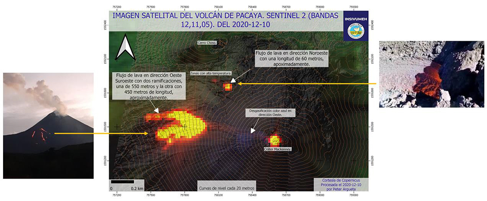
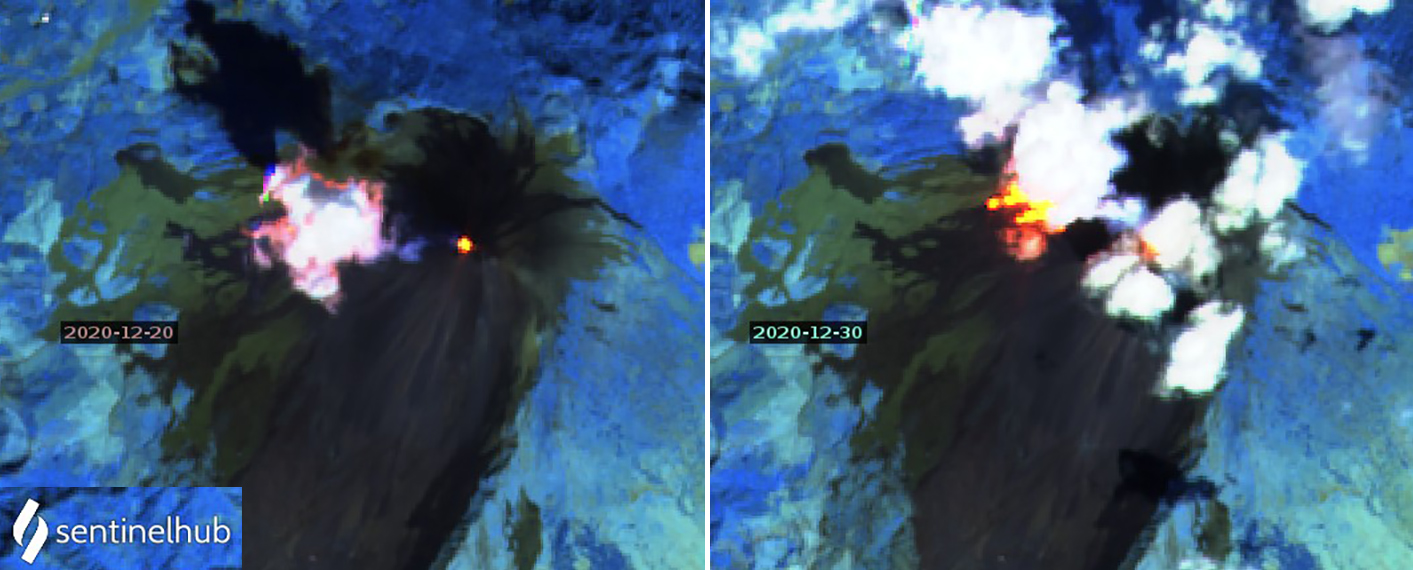
Lava flow activity continued on the SW flank throughout December 2020 and high winds remobilized ash on the flanks a number of times during the month. On 1 December the flow was about 675 m long and moving to the SW. Two branches were active the next day and three were reported on 6 December. A second flow appeared on the NW flank on 9 December on the plateau near Cerro Chino and grew to 250 m long (figure 147). Both flows had incandescent block avalanches spalling off their fronts and rolling at least 100 m. The SW-flank flow remained 450-550 m long through 11 December, and then grew to around 700 m the next day. Branches from both flows extended 700-1,000 m by 15 December and were moving NW, W, and SW. The NW-flank flow was growing through 16 December. Three 600-m-long branches were active on the SW-flank flow on 21 December. In a special bulletin released on 23 December, INSIVUMEH noted that the SW-flank flow was still active from the same mid-flank fissure where it originated on 20 October 2020, and consisted of 5-7 branches with lengths varying from 600-750 m (figure 148). For the remainder of December, multiple branches of the active SW-flank flow were between 525 and 650 m long, with block avalanches falling off the front that generated ash clouds.
In a special bulletin issued on 1 January 2021 INSIVUMEH reported an increase in eruptive activity that produced Strombolian explosions which sent ejecta 300 m high and up to 100 m from the summit. Constant rumblings like a train and shock waves were heard and felt in nearby communities. Strombolian explosions continued to rise 75-200 m above the rim throughout the month, and numerous gas emissions rose 100-300 m and drifted as far as 10 km (figure 149). Ash emissions were noted on 1, 6, 7, 11, 13, 18, 19, 21-23, 25, 27, and 31 January. On 7 January ash drifted SW at 3 km altitude and ejecta was reported 300 m from the summit. INSIVUMEH noted that the columns of ash reached 300-500 m above the crater that day, generating loud rumbling and shock waves that vibrated roofs and windows in nearby villages. On 12 January explosions sent material 300 m high. A VAAC report on 22 January noted an ash plume drifting NW from the summit at 3.4 km altitude. INSIVUMEH remarked in a special report that day that ash fell in San Vicente Pacaya and in San Francisco de Sales. The ash emissions on 25 January were brown to gray, sporadic overnight and more continuous in the early morning, drifting 1-4 km W. On 27 and 31 January ash drifted 10 km W.
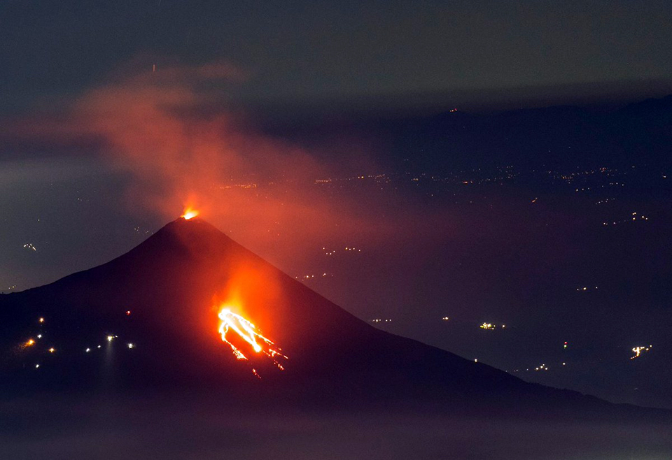
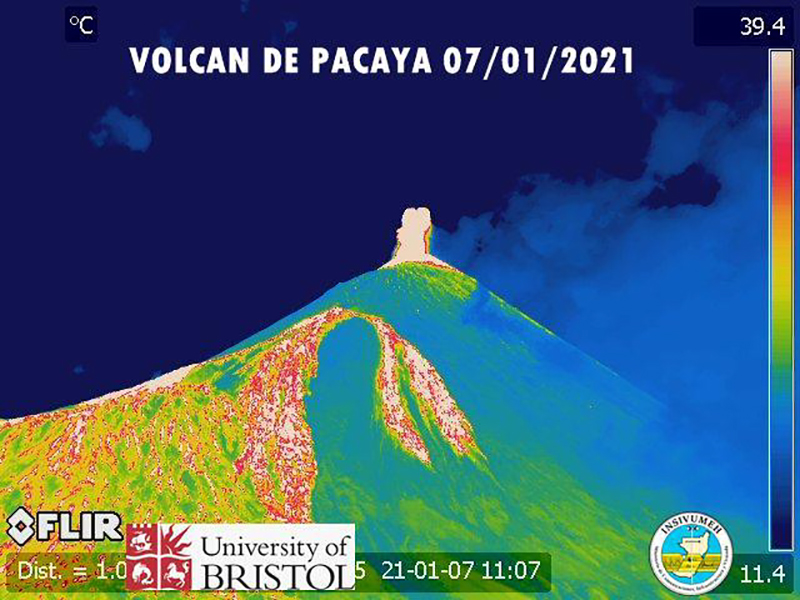
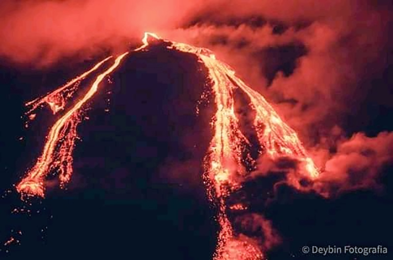
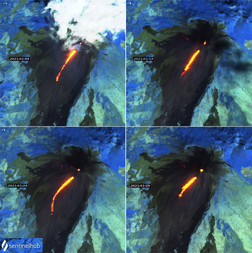
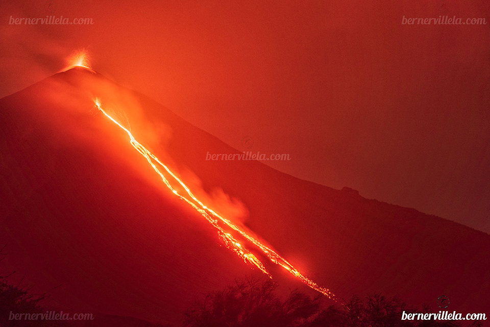
Multiple lava flows emerged from the flanks of Pacaya during January 2021. The lava flow that began on 20 October 2020 on the W flank continued to be active through about 8 January with branches flowing 400-600 m W and SW. A flow on the SSW flank began on 2 January from a vent 200 m below the rim of Mackenney crater. By 6 January it was feeding 3-4 flows from the same point, each 400 m long with block avalanches falling off the fronts and moving W, SW, and S down the flanks (figure 150). In the morning of 7 January two flows were seen on the N flank, 200 and 50 m long. Later that night another flow appeared on the SSW flank that lengthened rapidly, reaching 425 m the next day, and was 1,200 m long on 9 January (figure 151). High temperatures were still present on the W and SW flanks from the earlier flows. The SSW flow reached 1,500 m in length on 10 January and fluctuated between 1,200 and 1,600 m through 17 January when Strombolian activity ejecting material 5-10 m high was reported from the fissure. More Strombolian activity at the fissure was noted on 22 January, and the flow remained 800-1,150 m long through the 23rd. The flow reached 1,700 m in length on 25 January; for the rest of the month, it was reported as 800-1,000 m long, with block avalanches traveling an additional 200-400 m from the flow front. Strombolian activity reached 65 m high from the fissure at the head of the flow on 28 January. On 30 January multiple branches of the SSW flow were visible from a vantage point south of the volcano (figure 152).
Increased Strombolian activity during February 2021 was accompanied by frequent ash emissions that rose to 3.0-3.5 km altitude. The explosions often reached 225 m above the crater rim, and higher during pulses of increased activity. On 5 February ash drifted W, NW, and SW about 4 km and ashfall was reported in San Francisco de Sales, Concepcion el Cedro, and Calderas. A pulse of increased Strombolian activity on 6 February sent ejecta 400-500 m around the pyroclastic cone and columns of ash drifted 6 km NW and N. Ashfall was reported in the same areas as the day before, plus in El Bejucal, Mesías Altas and other communities in that region. Abundant ash emissions were reported by INSIVUMEH overnight on 7-8 February; variable winds dispersed the ash 30 km to the NW and W and 10 km N (figure 153). The ash emissions were accompanied by ejecta that landed 300 m from the summit. By the next day, ash had drifted as far as 66 km W and NW and ashfall was reported in El Patrocinio, El Rodeo, and El Caracol. Prolonged rumbling as loud as an airplane engine was reported from strong degassing. The Washington VAAC reported ash emissions in satellite imagery on 9 February at 3.8 km altitude drifting NW about 65 km from the summit.
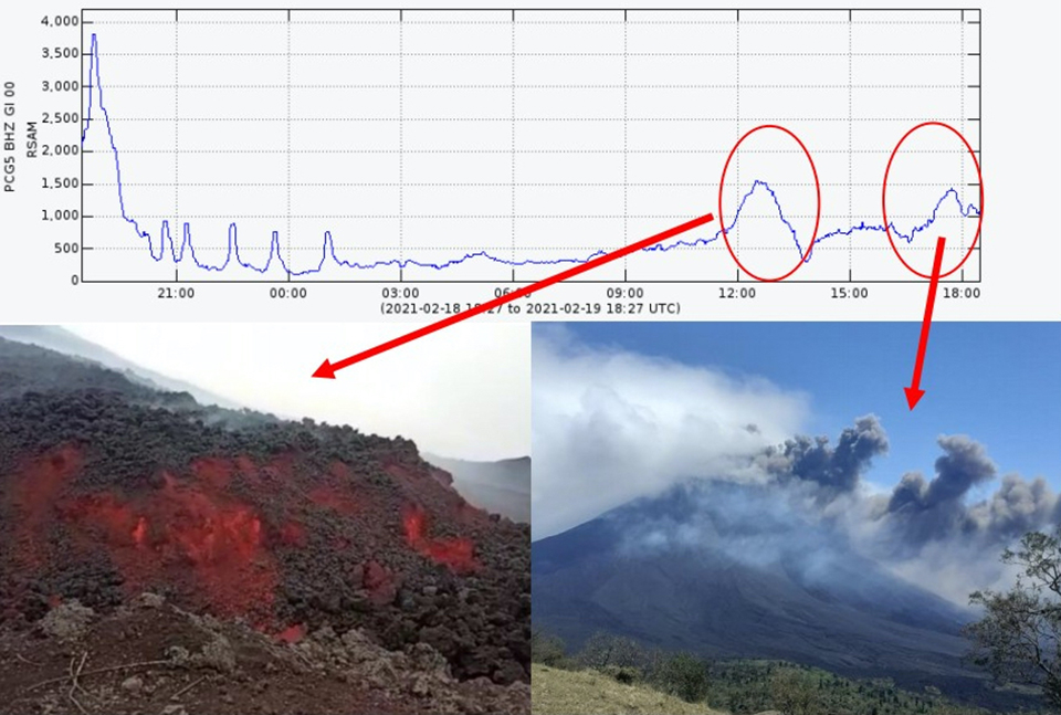
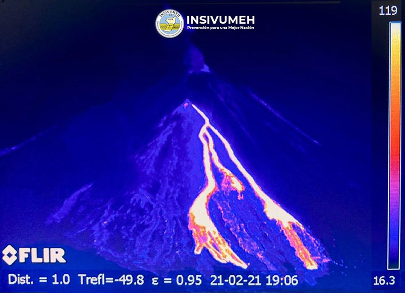
High levels of similar activity continued through 10 February when 500-m-high ejecta was observed inside Mackenney crater. An increase in the seismic amplitude on 11 February was accompanied by ash plumes rising to 3.0-3.2 km altitude and drifting 15-20 km W and SW. Ashfall was reported in Patrocinio and El Rodeo. The next day ashfall was reported in San Francisco de Sales, San Jose Calderas, and Concepción el Cedro. On 13 February the Washington VAAC reported ash plumes visible in satellite imagery at 4.3 km altitude moving ENE, and ash fell in Santa Elena Barillas, Mesillas Bajas, and Mesillas Altas as the wind carried ash 6 km W, N, and NE; ash on 14 February drifted 5 km E. A new pulse of activity late on 16 February, the third in a week, produced incandescent material 400 m high; high-pressure gas also created plane engine noises, with roofs and windows rattled in nearby communities. Ashfall from the event was reported in Los Llanos, Los Pocitos, El Cedro, and other communities within 4 km. Another pulse on 18 February sent ejecta 200 m high, variable winds sent ash primarily NE and S. Two more pulses of activity on the morning of 19 February were recorded as increases in seismic amplitude by the PCG5 seismic station (figure 154). The first pulse was accompanied by a new lava flow appearing on the NW flank. The second pulse coincided with ash emissions that rose 500 m above the crater and drifted 8 km S, producing ashfall in Los Pocitos and plantations in that vicinity.
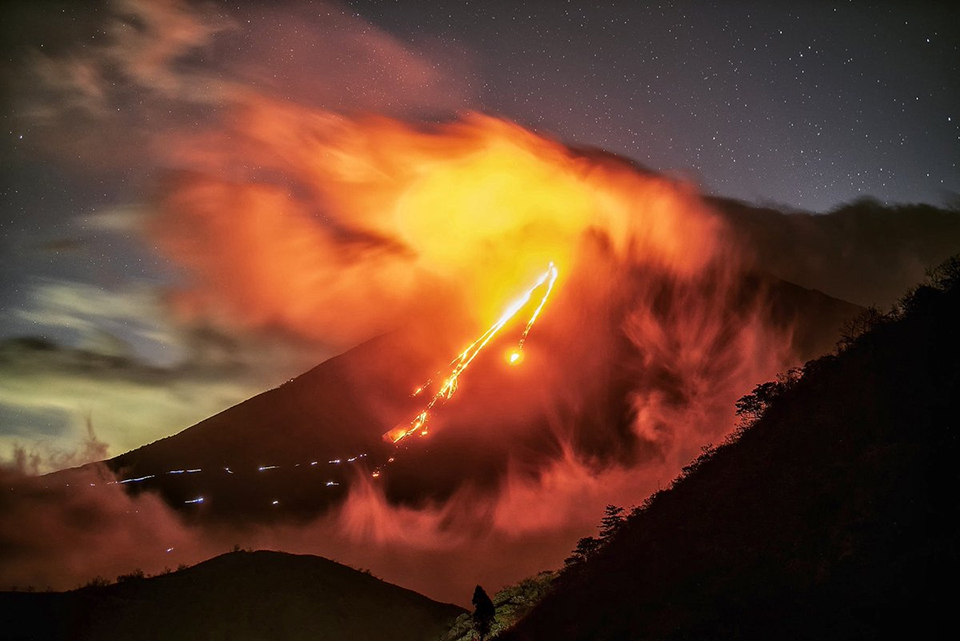
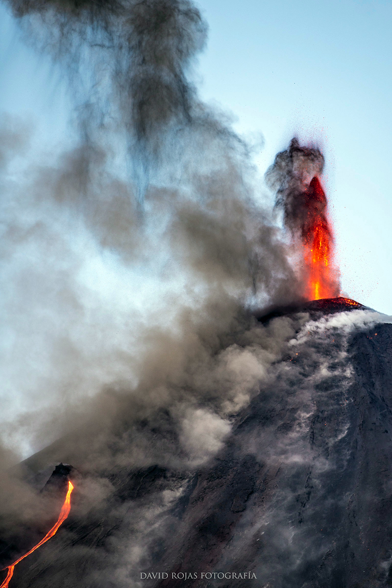
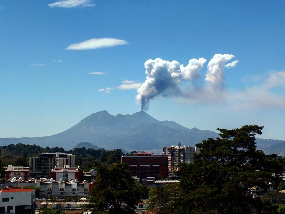
Ash emissions from explosions on 20 February drifted 10-25 km S and SW, resulting in ashfall in El Rodeo and El Patrocinio. That evening incandescent material rose 300-400 m above the summit and ejecta reached 500 m down the flanks of the cone (figure 155). The next day ash plumes rose to 2.8-3.2 km altitude and drifted SW with ashfall reported in San Francisco de Sales, El Cedro, and other plantations in the area (figure 156). During 22-24 February ash emissions rose as high as 800 m above the summit and drifted 3-5 km W, SW, and S. Ashfall drifted over 30 km S and SW on 24 February with ashfall reported in the villages of Los Pocitos, Pacaya, El Rodeo, and El Patrocinio. Pulses of increased activity on 26 February produced an ash plume 2.5 km above the summit. With variable wind directions at different altitudes, the ash drifted both N and S. The Washington VAAC reported the plume drifting N at 3.9 km altitude. This activity was accompanied by incandescent explosions that rose 500 m above the Mackenney crater, and noises as loud as an airplane engine. Similar pulses of activity continued through the end of the month, producing ash plumes that rose to 3.5 km altitude and drifted W and SW; ashfall was reported in El Patrocinio on 28 February.
The lava flow on the SSW flank was about 900 m long at the beginning of February with block avalanches falling about 100 m from the front of the flow, and Strombolian explosions active at the fissure at the head of the flow. Two distinct branches of the flow were visible on 6 February, one 1,200 and one 800 m long; multiple branches were active throughout the month (figure 157). High levels of activity continued; during 10-12 February the flow was 1,200-1,300 m long and loose blocks were descending an additional 200 m. During 13-18 February high temperature zones were still present on the N and NW flanks from earlier flows. From 14-18 February the S-flank flow was 900-1,100 m long with multiple branches and Strombolian activity at the vent (figure 158). A new flow appeared briefly on the NW flank during 19-20 February. High-temperature zones remained on the NW flank during 22-24 February. The S-flank flow remained active throughout the rest of February and was 800-1,100 m long, with incandescent blocks traveling up to 600 m beyond the flow fronts (figure 159).
Geological Summary. Eruptions from Pacaya are frequently visible from Guatemala City, the nation's capital. This complex basaltic volcano was constructed just outside the southern topographic rim of the 14 x 16 km Pleistocene Amatitlán caldera. A cluster of dacitic lava domes occupies the southern caldera floor. The post-caldera Pacaya massif includes the older Pacaya Viejo and Cerro Grande stratovolcanoes and the currently active Mackenney stratovolcano. Collapse of Pacaya Viejo between 600 and 1,500 years ago produced a debris-avalanche deposit that extends 25 km onto the Pacific coastal plain and left an arcuate scarp inside which the modern Pacaya volcano (Mackenney cone) grew. The NW-flank Cerro Chino crater was last active in the 19th century. During the past several decades, activity has consisted of frequent Strombolian eruptions with intermittent lava flow extrusion that has partially filled in the caldera moat and covered the flanks of Mackenney cone, punctuated by occasional larger explosive eruptions that partially destroy the summit.
Information Contacts: Instituto Nacional de Sismologia, Vulcanologia, Meteorologia e Hydrologia (INSIVUMEH), Unit of Volcanology, Geologic Department of Investigation and Services, 7a Av. 14-57, Zona 13, Guatemala City, Guatemala (URL: http://www.insivumeh.gob.gt/ ); MIROVA (Middle InfraRed Observation of Volcanic Activity), a collaborative project between the Universities of Turin and Florence (Italy) supported by the Centre for Volcanic Risk of the Italian Civil Protection Department (URL: http://www.mirovaweb.it/); Hawai'i Institute of Geophysics and Planetology (HIGP) - MODVOLC Thermal Alerts System, School of Ocean and Earth Science and Technology (SOEST), Univ. of Hawai'i, 2525 Correa Road, Honolulu, HI 96822, USA (URL: http://modis.higp.hawaii.edu/); Washington Volcanic Ash Advisory Center (VAAC), Satellite Analysis Branch (SAB), NOAA/NESDIS OSPO, NOAA Science Center Room 401, 5200 Auth Rd, Camp Springs, MD 20746, USA (URL: www.ospo.noaa.gov/Products/atmosphere/vaac, archive at: http://www.ssd.noaa.gov/VAAC/archive.html); Sentinel Hub Playground (URL: https://www.sentinel-hub.com/explore/sentinel-playground); Deybin Fotografía (URL: https://www.facebook.com/Deybin-fotografía-2316704905277353, https://twitter.com/UniversoNews1/status/1347037016324792327); David Rojas (URL: https://twitter.com/DavidRojasGt/status/1360789438545149957); Luis Figueroa (URL: https://twitter.com/luisficarpediem/status/1363664541318598657); Berner Villela (URL: https://bernervillela.com/galerias/naturaleza, https://twitter.com/soy_502/status/1362846917743366146); Roberto Iboy (URL: https://twitter.com/IboyRoberto/status/1363688900401709057).