Report on Villarrica (Chile) — March 2021

Bulletin of the Global Volcanism Network, vol. 46, no. 3 (March 2021)
Managing Editor: Edward Venzke.
Edited by Kadie L. Bennis.
Villarrica (Chile) Explosions, ash plumes, crater incandescence, and an active lava lake during September 2020-February 2021
Please cite this report as:
Global Volcanism Program, 2021. Report on Villarrica (Chile) (Bennis, K.L., and Venzke, E., eds.). Bulletin of the Global Volcanism Network, 46:3. Smithsonian Institution. https://doi.org/10.5479/si.GVP.BGVN202103-357120
Villarrica
Chile
39.42°S, 71.93°W; summit elev. 2847 m
All times are local (unless otherwise noted)
Villarrica, located in Chile, has had historical eruptions dating back to 1558. The current eruption period began in December 2014 and more recently has been characterized by summit crater incandescence, Strombolian explosions, and ash emissions (BGVN 45:09). This report covers activity during September 2020 through February 2021, which consists of an active lava lake, explosions, ash plumes, and nighttime crater incandescence. Information is provided by the Southern Andes Volcano Observatory (Observatorio Volcanológico de Los Andes del Sur, OVDAS), part of Chile's National Service of Geology and Mining (Servicio Nacional de Geología y Minería, SERNAGEOMIN), the Projecto Observación Villarrica Internet (POVI), part of the Fundacion Volcanes de Chile, a private research group that studies volcanoes across Chile, the Buenos Aires Volcanic Ash Advisory Center (VAAC), and various satellite data.
Activity during September 2020 was characterized by an active lava lake, white gas-and-steam plumes that rose 500 m above the crater, nighttime crater incandescence that could be observed on clear days, and sporadic ash emissions produced by minor explosions. During 5 and 7 September tephra deposits extended up to 36 m on the E and SE flanks, according to satellite data. On 25 September the seismic network recorded a long-period earthquake associated with a moderate explosion at 1350, which produced an ash plume that rose 800 m above the crater and drifted ENE (figure 104); blocks of ejecta were deposited around the crater. A second explosion was recorded at 1829 in conjunction with another long-period event, which generated an ash plume that rose 450 m above the crater (figure 104). Sentinel L2 A satellite images were used to determine that ashfall extended 3.8 km SSE, 865 m SE, and 275 m N as a result of the explosions during the day. The POVI webcam captured incandescent ejecta at night on 27 September (figure 105).
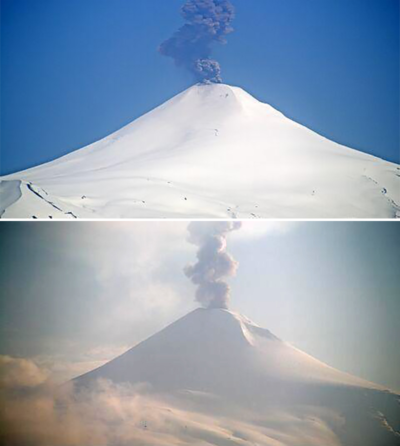 |
Figure 104. Explosions at Villarrica on 25 September 2020 at 1350 (top) and 1829 (bottom) produced a long-period seismic signal and ash plumes that rose 800 m and 450 m above the crater, respectively and drifted ENE. Courtesy of SERNAGEOMIN (Reporte Especial de Actividad Volcanica (REAV), Region De La Araucania y Los Rios, Volcan Villarrica, 25 de septiembre de 2020, 14:35 Hora local y 25 de septiembre de 2020, 19:20 Hora local). |
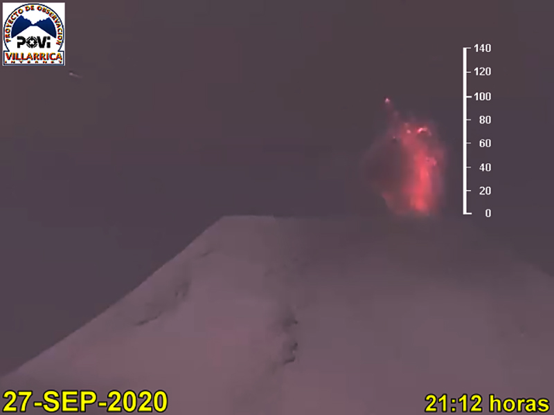 |
Figure 105. Incandescent ejecta up to 100 m above the summit of Villarrica was captured in the POVI webcam at night on 27 September 2020. Courtesy of POVI. |
Intermittent white gas-and-steam plumes, ash explosions, and nighttime crater incandescence continued during October. On 4 October SERNAGEOMIN reported a long-period event accompanied by a moderate explosion at 1130, generating an ash plume that rose 450 m above the crater and drifted NE. The next day on 5 October two long-period events were recorded at 1343 and 1347 associated with explosions, resulting in ash plumes that rose to 400 m above the crater and drifted SE (figure 106). On 12 October a satellite image showed an ash plume drifting 2.5 km NE and a strip of tephra deposits measuring 200 m wide and 3 km long on the NE flank, as a result of two eruptive events on 9 October, according to POVI and Sentinel-2 satellite imagery.
 |
Figure 106. Explosions at Villarrica on 5 October 2020 produced a long-period seismic signal and an ash plume that rose 400 m above the crater and drifted SE. Courtesy of SERNAGEOMIN (Reporte Especial de Actividad Volcanica (REAV), Region De La Araucania y Los Rios, Volcan Villarrica, 5 de octubre de 2020, 14:20 Hora local). |
Moderate explosions were detected at 0534 and 0804 on 15 October, associated with two long-period earthquakes. As a result, ash plumes rose as high as 900 m above the crater and gas-and-steam plumes rose to 450 m, according to SERNAGEOMIN. The explosion at 0534 was accompanied by crater incandescence and incandescent ejecta that were deposited on the E flank as far as 3 km. An analysis of Planet Scope and Sentinel-2 satellite images showed that ash deposits extended 4.4 km NE. On 20 October an explosion and long-period event were recorded at 1722 that resulted in an ash plume 240 m above the crater that drifted S (figure 107). Explosions recorded during 22-23 October produced ash plumes that rose 780 m and 180 m above the crater, respectively, according to a Buenos Aires VAAC report and SERNAGEOMIN. The event on 22 October deposited tephra up to 3.8 km on the E flank.
 |
Figure 107. An explosion at Villarrica on 20 October 2020 at 1722 was characterized by a long-period earthquake and a dense, gray ash plume that rose 240 m above the crater and drifted S. Courtesy of SERNAGEOMIN (Reporte Especial de Actividad Volcanica (REAV), Region De La Araucania y Los Rios, Volcan Villarrica, 20 de octubre de 2020, 18:00 Hora local). |
Ash explosions continued in November, accompanied by intermittent nighttime crater incandescence and white gas-and-steam plumes. On 5 November a pulse of ash was observed at 1442 that rose 350 m above the crater and drifted NW. Similar activity was noted on 6 November at 0757 and 0808 when ash rose 350 m above the crater and at 1412 when ash rose 250 m above the crater, both of which drifted NW (figure 108). According to a Buenos Aires VAAC report on 7 November, an isolated ash plume was detected in satellite images up to 4.3 km altitude, drifted ESE. A Differential Absorption Optical Spectroscopy Unit (DOAS) showed average values of SO2 totaling 140 tons/day during 7-8 and 15 November with a maximum daily value of 168 tons/day on 7 November. An explosive event at 0051 on 8 November ejected incandescent material and produced an ash plume that rose 220 m above the crater (figure 108). On 10 November OVDAS reported an ash plume rose 320 m above the crater and drifted SSW, accompanied by continuous seismic tremor at 1514. Ash continued to be reported during 16-17 November rising 160 m above the crater and to 3.7 km altitude, respectively. Data from the DOAS showed that SO2 emissions had slightly increased to an average of 166 tons/day during 16-30 November, with a maximum daily value of 549 tons/day on 22 November.
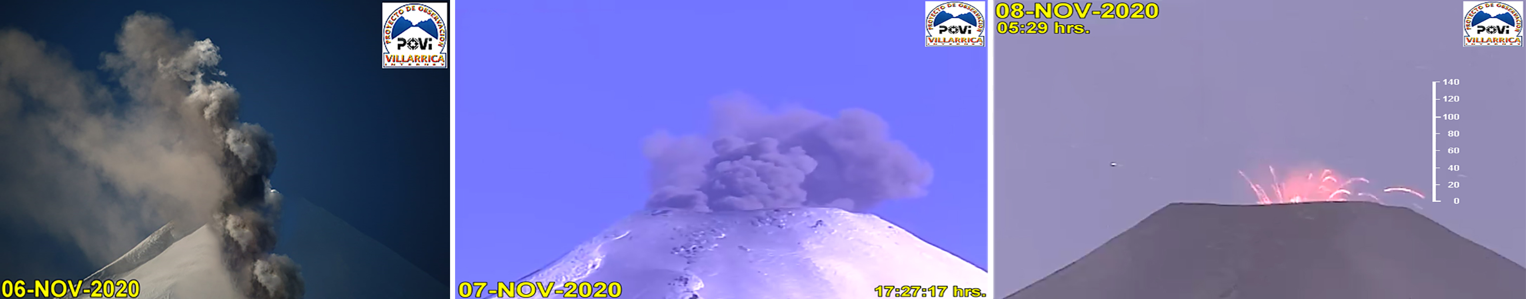 |
Figure 108. Explosions that generated ash and incandescent ejecta at the summit of Villarrica were captured by the POVI webcam during 6-8 November 2020 (left to right). Courtesy of POVI. |
The number of ash events decreased in December compared to the previous months, though similar activity persisted. On clear nights, crater incandescence was visible, accompanied by white gas-and-steam emissions. SERNAGEOMIN reported a single long-period earthquake associated with a moderate explosion at 1844 on 5 December with a resulting ash plume that rose 160 m above the crater and drifted SSE; some ashfall was detected within 500 m of the crater, based on Sentinel-2, Pleiades, and SkySat data, and incandescent material was deposited on the SSE flanks (figure 109). According to POVI, during an overflight on 9 December scientists observed a lava lake 10-15 m in diameter that was partially covered by solidified floating black lava. Small pulses of gas and ash were observed in the lava lake. Additionally, ballistic blocks and pyroclasts that measured a maximum of 20 cm in diameter had been ejected up to 800 m from the crater during previous eruptive events. The average SO2 value was 178 tons/day with a maximum daily value of 353 tons/day on 7 December 2020, according to DOAS data.
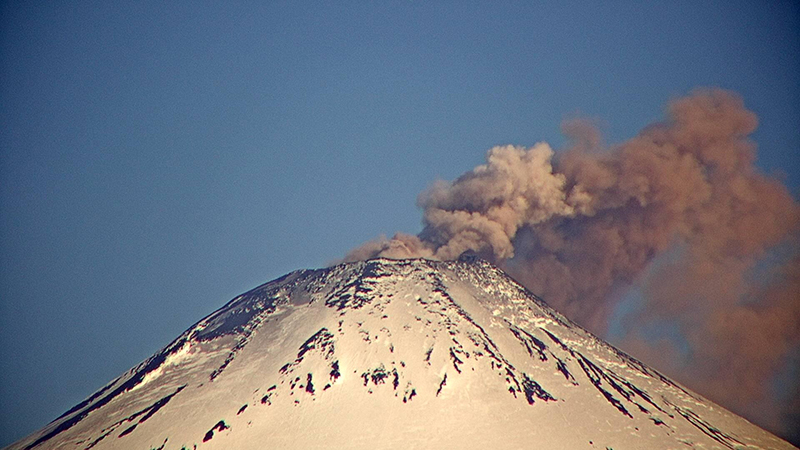 |
Figure 109. An explosion at Villarrica on 5 December 2020 at 1844 produced a long-period seismic signal along with an ash plume that rose 160 m crater and drifted SSE. Courtesy of SERNAGEOMIN (Reporte Especial de Actividad Volcanica (REAV), Region De La Araucania y Los Rios, Volcan Villarrica, 5 de diciembre de 2020, 19:50 Hora local). |
On 16 December at both 1146 and 1156 SERNAGEOMIN reported two ash pulses associated with long-period events. The first ash emission rose 160 m above the crater and drifted NW; the second rose 280 m above the crater and drifted 500 m NE. On 17 December at 1716 another ash plume associated with a long-period event rose 720 m above the crater and drifted ESE (figure 110). Pyroclastic deposits were reported up to 1.3 km N, 3.3 km E, 5 km SE, and 1.8 km SW from the crater, according to data obtained from Sentinel-2 and SkySat. During 18-19 December seismicity increased, intense crater incandescence was visible, and a notable sulfur odor was noted, according to POVI reports. Minor ash emissions rose to low heights on 22 December.
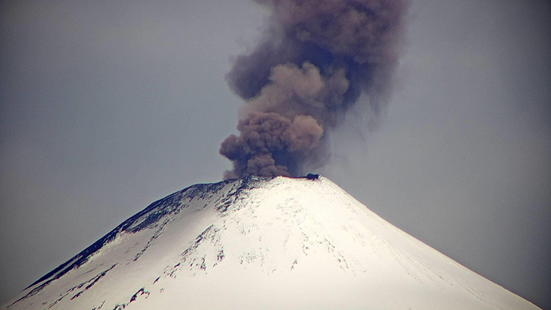 |
Figure 110. An explosion at Villarrica on 17 December 2020 at 1716 produced an ash plume that rose 720 m above the crater and drifted ESE. Courtesy of SERNAGEOMIN (Reporte Especial de Actividad Volcanica (REAV), Region De La Araucania y Los Rios, Volcan Villarrica, 17 de diciembre de 2020, 17:50 Hora local). |
During January 2021, the number of explosions with ash plumes continued to decrease compared to the previous months. On clear weather days, occasional nighttime crater incandescence was observed, as well as white gas-and-steam emissions of variable intensities. During an overflight on 2 January scientists observed an incandescent vent at the bottom of the crater that had a solidified lava bridge connecting across a partially crusted-over top (figure 111). DOAS data showed that the average mass of SO2 plumes had increased compared to November and December to 318 tons/day with a maximum daily value of 789 tons/day on 12 January. During 1-15 January, the highest ash plume reported rose 700 m above the crater, though it was mostly composed of gas-and-steam emissions. During 16-31 January gas-and-steam emissions continued, rising to 1.3 km above the crater on 20 January. The average value of SO2 plumes increased again to 430 tons/day with a maximum daily value of 789 tons/day on 22 January.
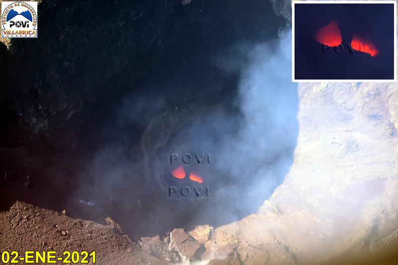 |
Figure 111. Webcam image of two incandescent vents at Villarrica on 2 January 2021. A bridge of solidified lava separates the two sections and extends across the active lava lake. Courtesy of POVI. |
Activity during February continued to decrease compared to the previous months and consisted of primarily white gas-and-steam plumes, nighttime crater incandescence, and SO2 plumes. On 10 February dense, white gas-and-steam plumes rose 700 m above the crater. During 1-15 February, the average value of SO2 plumes was 181 tons/day with a maximum daily value of 369 tons/day on 2 February. Long-period earthquakes were recorded by the seismic network at 1146 and 1156 on 16 February with an associated explosion that generated ash plumes 160 m above the crater that drifted NW and 280 m that drifted NE, respectively. During 16-28 February white gas-and-steam plumes rose to a high of 780 m above the crater; SO2 plumes were an average value of 402 tons/day with a maximum daily value of 1,026 tons/day on 21 February.
Low-power thermal activity was detected during September 2020 through January 2021, according to the MIROVA Log Radiative Power graph using MODIS infrared satellite information (figure 112). Three thermal anomalies were recorded in September, one in October, and four in November; a single stronger anomaly was observed in early November. The number of anomalies increased in late December through late January 2021, though they remained low in power. On clear weather days, a strong thermal anomaly in the summit crater was visible in Sentinel-2 thermal satellite imagery during each month of the reporting period; in February, the strength of the anomaly had slightly decreased compared to previous months (figure 113).
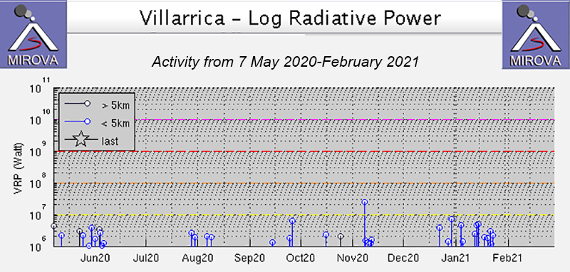 |
Figure 112. Low-power thermal anomalies were detected in the MIROVA graph (Log Radiative Power) at Villarrica during September 2020 through late January 2021. A pulse of thermal anomalies was recorded during late December 2020 through late January 2021 compared to the previous month but remained low in power. Courtesy of MIROVA. |
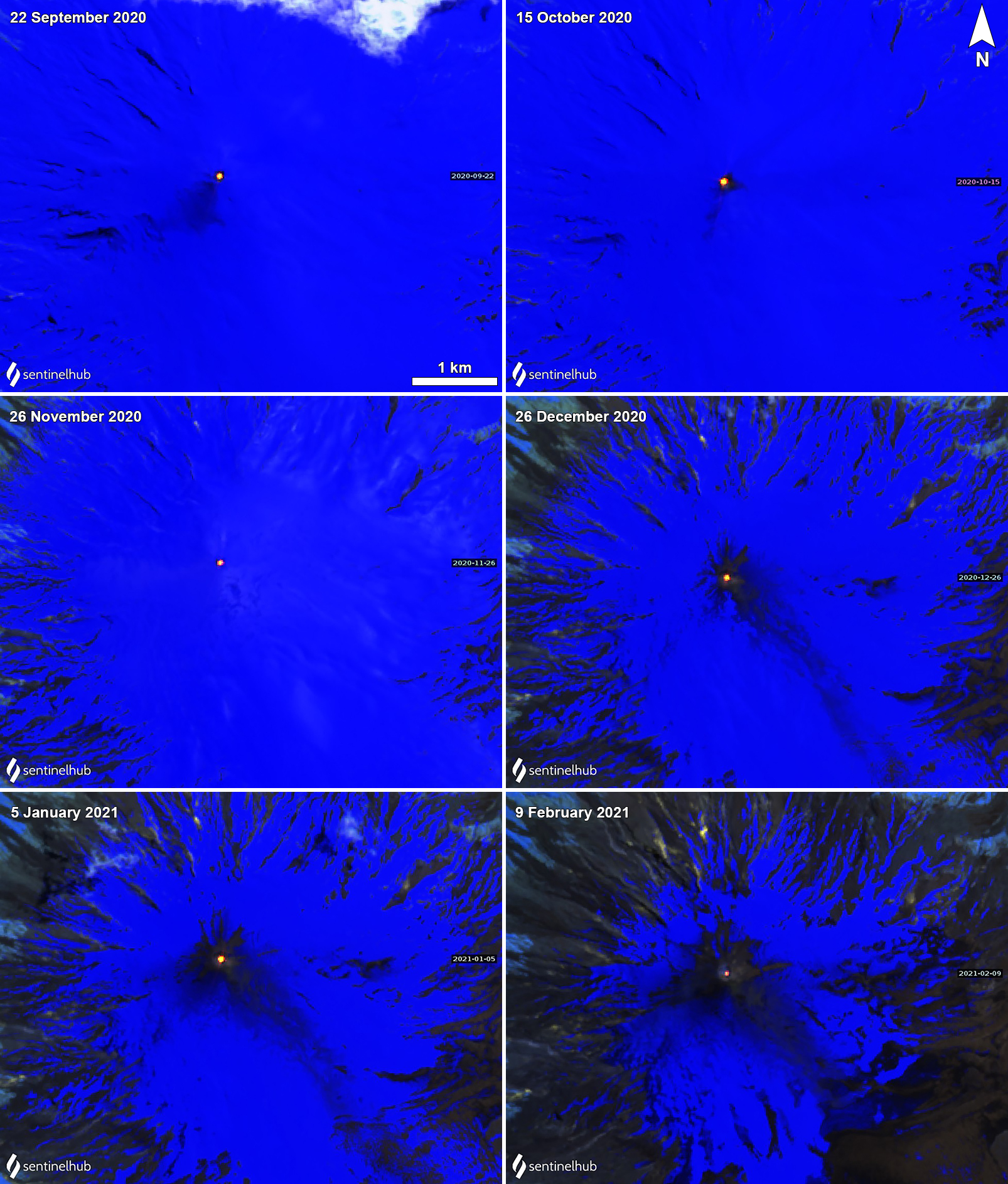 |
Figure 113. Sentinel-2 thermal satellite images showing strong thermal anomalies on clear weather days in the summit crater of Villarrica each month from September 2020 through February 2021. The strength of the thermal anomaly in February decreased slightly compared to previous months. Sentinel-2 satellite images with “Atmospheric penetration” (bands 12, 11, 8A) rendering. Courtesy of Sentinel Hub Playground. |
Geological Summary. The glacier-covered Villarrica stratovolcano, in the northern Lakes District of central Chile, is ~15 km south of the city of Pucon. A 2-km-wide caldera that formed about 3,500 years ago is located at the base of the presently active, dominantly basaltic to basaltic andesite cone at the NW margin of a 6-km-wide Pleistocene caldera. More than 30 scoria cones and fissure vents are present on the flanks. Plinian eruptions and pyroclastic flows that have extended up to 20 km from the volcano were produced during the Holocene. Lava flows up to 18 km long have issued from summit and flank vents. Eruptions documented since 1558 CE have consisted largely of mild-to-moderate explosive activity with occasional lava effusion. Glaciers cover 40 km2 of the volcano, and lahars have damaged towns on its flanks.
Information Contacts: Servicio Nacional de Geología y Minería (SERNAGEOMIN), Observatorio Volcanológico de Los Andes del Sur (OVDAS), Avda Sta María No. 0104, Santiago, Chile (URL: http://www.sernageomin.cl/); Proyecto Observación Villarrica Internet (POVI) (URL: http://www.povi.cl/); Buenos Aires Volcanic Ash Advisory Center (VAAC), Servicio Meteorológico Nacional-Fuerza Aérea Argentina, 25 de mayo 658, Buenos Aires, Argentina (URL: http://www.smn.gov.ar/vaac/buenosaires/inicio.php); MIROVA (Middle InfraRed Observation of Volcanic Activity), a collaborative project between the Universities of Turin and Florence (Italy) supported by the Centre for Volcanic Risk of the Italian Civil Protection Department (URL: http://www.mirovaweb.it/); Sentinel Hub Playground (URL: https://www.sentinel-hub.com/explore/sentinel-playground).