Sabancaya
Peru
15.787°S, 71.857°W; summit elev. 5960 m
All times are local (unless otherwise noted)
Although tephrochronology has dated activity at Sabancaya back several thousand years, renewed activity that began in 1986 was the first recorded in over 200 years. A new period of explosive activity that began in November 2016 has been characterized by pulses of ash emissions with some plumes exceeding 10 km altitude, frequent thermal anomalies, and significant SO2 plumes. Daily ash emissions and high levels of SO2 continued during October 2020-March 2021, the period covered in this report. The Observatorio Vulcanologico INGEMMET (OVI) reported daily on numbers of explosions, ash plume heights and directions of drift, seismicity, ashfall, and other activity; IGP (Instituto Geophysico del Peru) issued weekly reports of activity.
Activity at Sabancaya during October 2020-March 2021 consisted of multiple daily explosions with dense gas-and-ash plumes, SO2 emissions, and persistent thermal anomalies from the summit crater. OVI and INGEMMET confirmed the presence of a second dome inside the summit crater in mid-November. Ash plumes rose 1-2 km above the summit on most days; higher plumes occasionally reached 2.5-3.0 km above the summit. Ash most commonly drifted W and SW, but there were significant periods where the wind sent ash N and NE. Ashfall was reported in communities around the volcano on 3-8 days each month. The Buenos Aires Volcanic Ash Advisory Center (VAAC) issued three or four daily reports of ongoing ash emissions throughout the period. The plumes generally rose to 7.3-8.2 km altitude and drifted in various directions, often visible in satellite imagery.
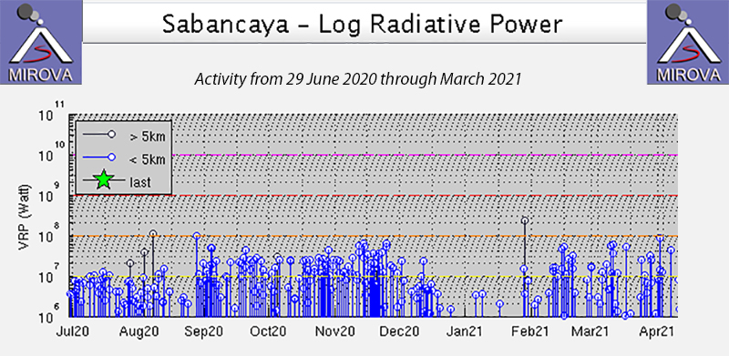
Moderate levels of thermal energy were reported by the MIROVA project during July 2020-March 2021. Power values were generally consistent, with a small increase in November and a brief drop from late December through January 2021 (figure 90). The MODVOLC system reported nine thermal alerts in October, 12 in November, one in December, none in January, and four each both February and March. Moderate to strong SO2 emissions were recorded virtually every day during the period by the TROPOMI instrument on the Sentinel-5P satellite (figure 91).
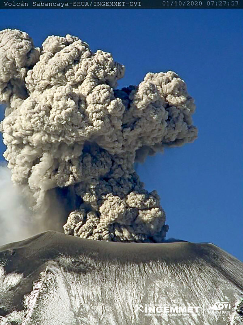
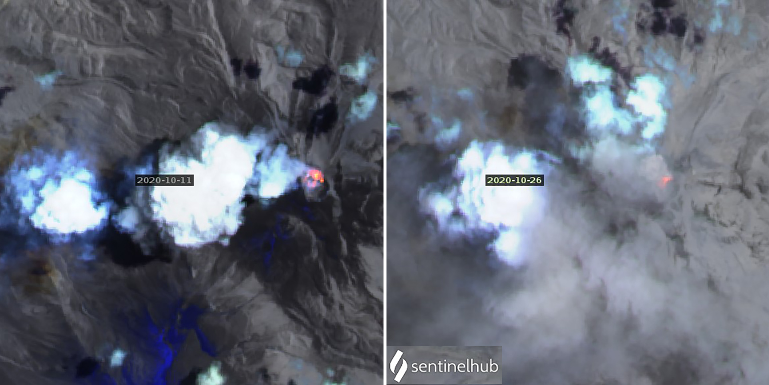
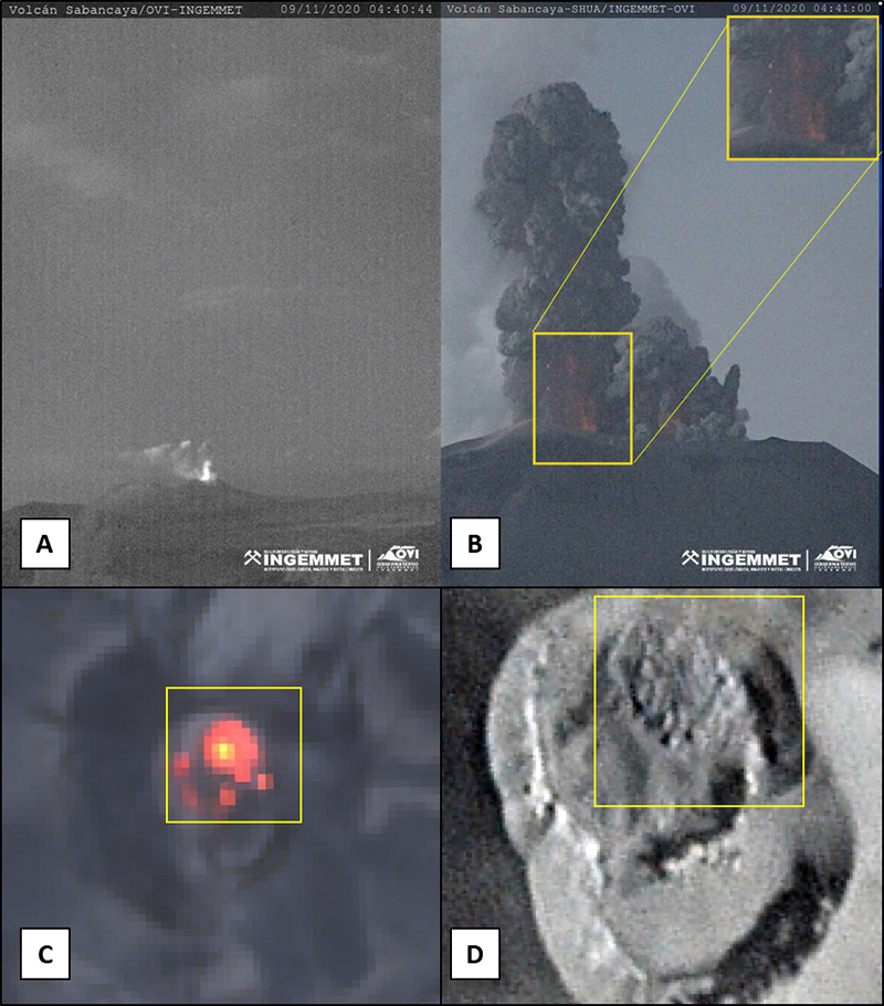
The Buenos Aires VAAC reported intermittent pulses of ash moving SE from the summit at 7.6 km altitude on 1 October 2020 (figure 92). Continuous ash emissions were reported at 7.3-7.9 km altitude throughout the month, resulting in several reports of ashfall. Ash was reported in Lluta on 5-6 October, in Taya on 6 October, in Huanca on 10 and 15 October, in Maca and Lari on 18, 27, and 28 October, in Madrigal on 18 and 27-29 October, and in Chivay on 27 and 29 October. Ash was also visible in satellite imagery on 16 and 26 October. Thermal anomalies were present in satellite images on 1, 6, 11, 16, and 26 October (figure 93).
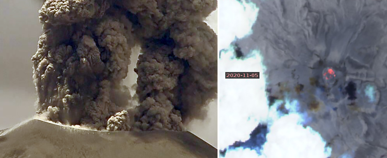
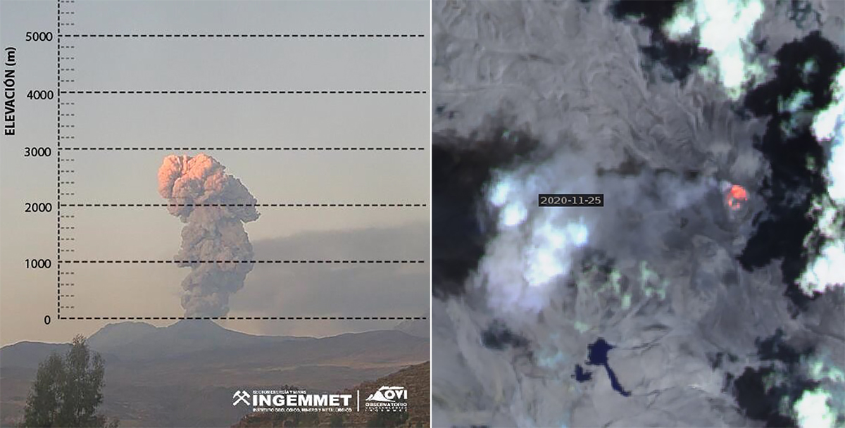
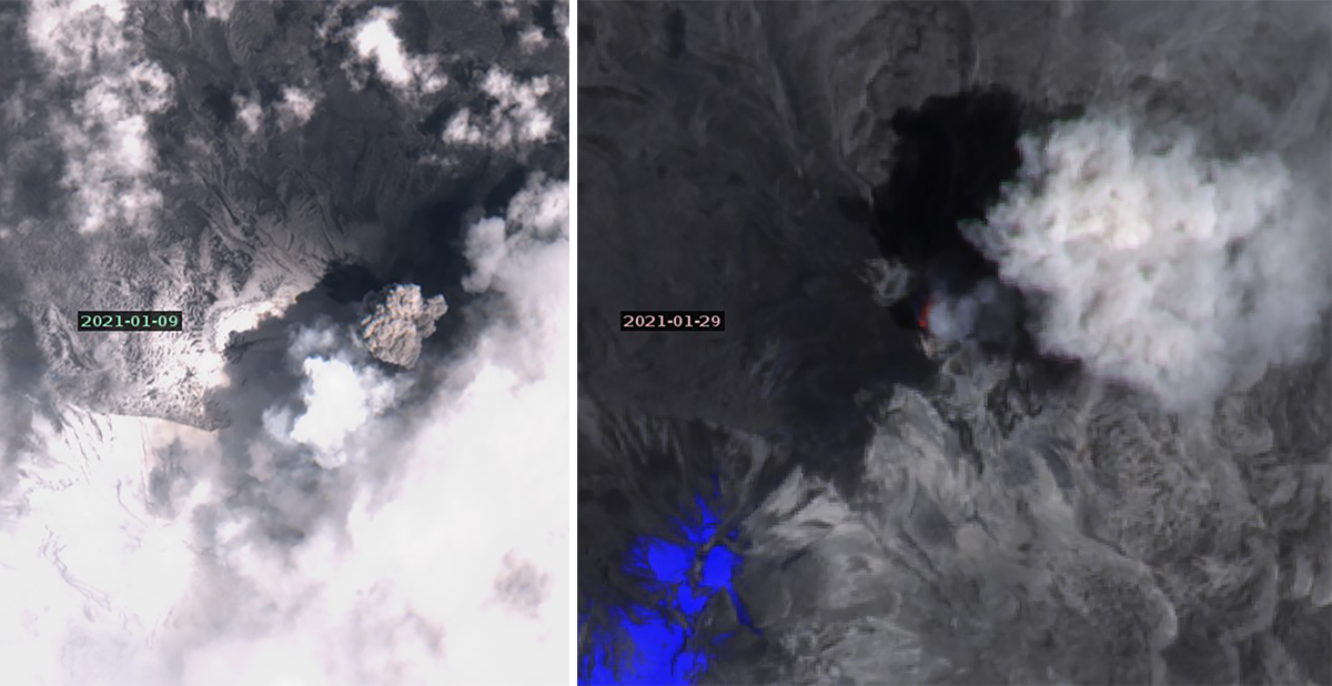
Strong thermal anomalies appeared in satellite images on 5, 10, 15, 20, and 25 November 2020. Two distinct ash plumes rose from the summit crater on 5 November, and thermal anomalies were also present in multiple areas of the crater in satellite images that day (figure 94). OVI reported the existence of a second dome in the summit crater the next day. In a report issued on 17 November INGEMMET named the second dome “Iskay” and identified it in the NE part of the crater using satellite images; it was about 12,000 m2 in size (figure 95). On 25 November thermal signals from both domes were visible in satellite imagery along with an ash plume drifting W that rose to 2,900 m above the summit (figure 96). Ashfall was reported in both Madrigal and Lari on 14 and 16 November, in Lluta on 25 November, and in Huambo on 25-28 November.
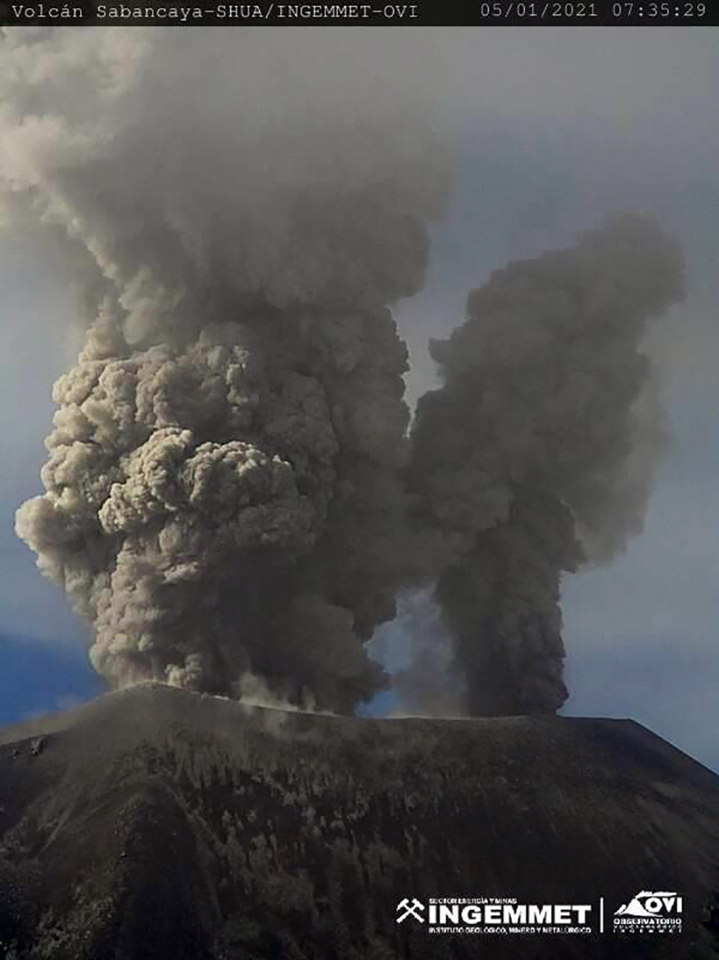
Ash emissions continued from both areas of the summit during December 2020 (figure 97); a thermal anomaly was recorded in a satellite image on 15 December. Ashfall was reported in Cabanaconde on 1, 8, and 10 December and was also reported in Pinchollo and Madrigal on 10 December. Two dense ash plumes on 5 January 2021 confirmed that both summit domes were still active (figure 98). Ash emissions appeared in satellite images on 4, 9, and 29 January 2021, along with a thermal anomaly on 29 January (figure 99). Ashfall was reported in Huanca on 15 January, Huambo on 18 January, Madrigal and Pinchollo on 27 January, and in Chivay on 29 January. A lahar descended the Pinchollo ravine near Huayraray around 1610 on 20 January.
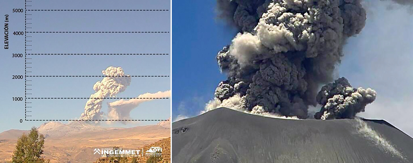
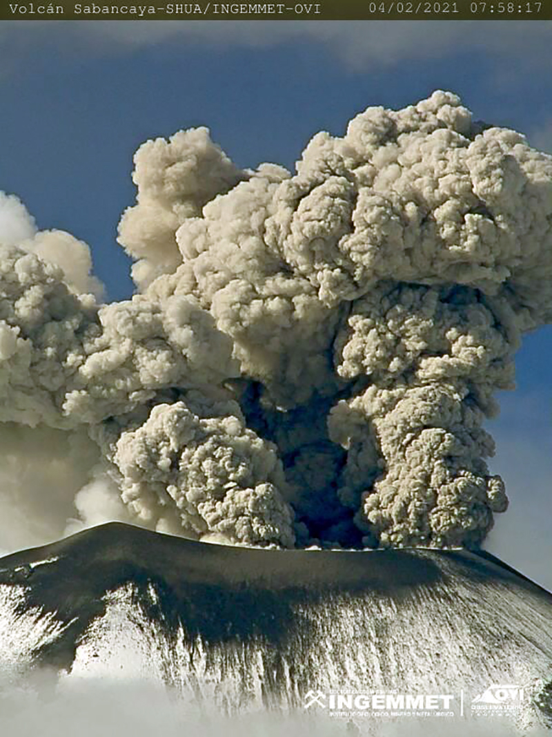
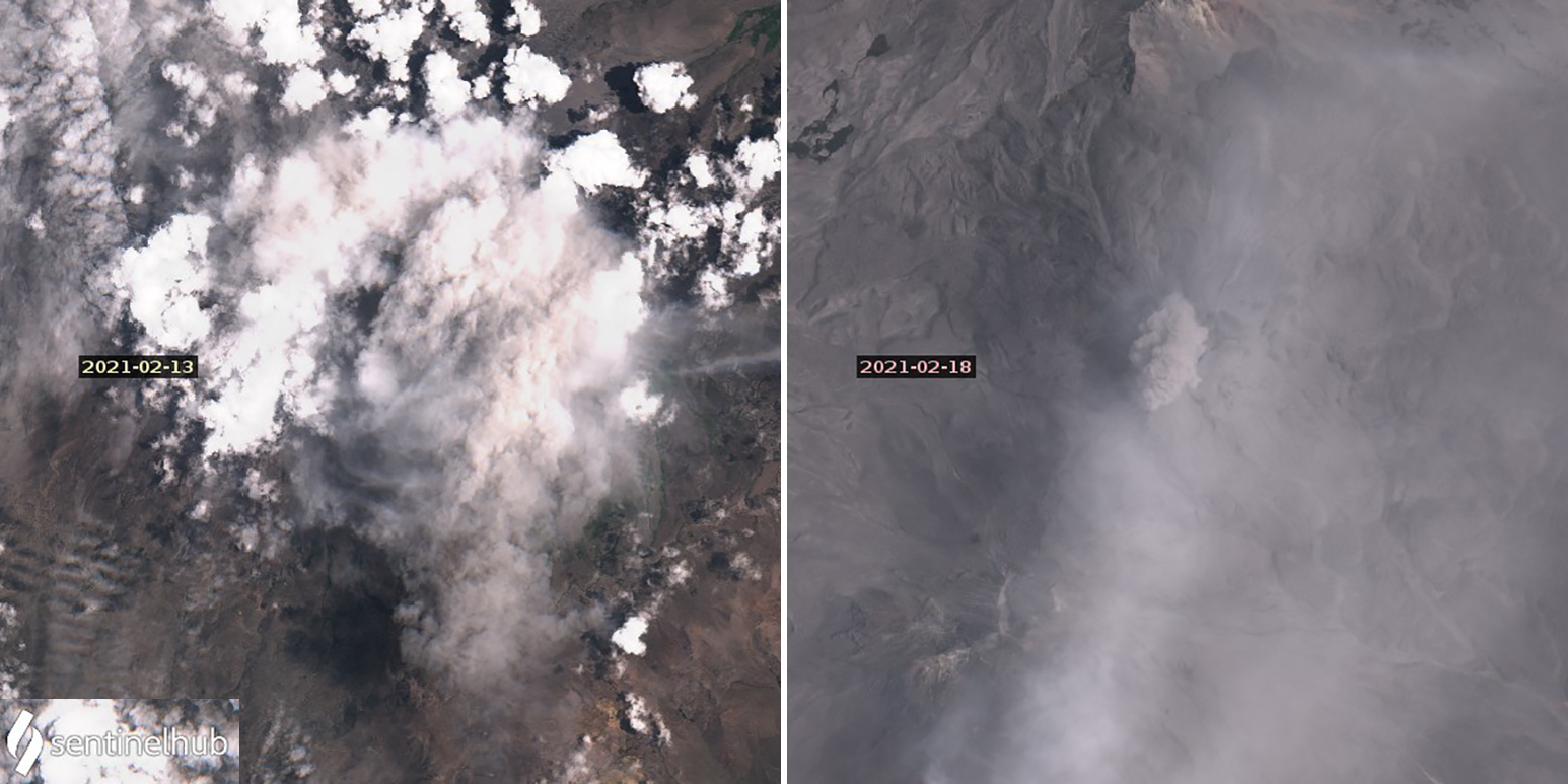
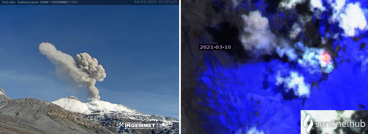
Daily ash emissions continued during February 2021 with plumes that rose as high as 3 km above the summit (figure 100). Ash plumes were visible in satellite images on 13 and 18 February (figure 101). Ashfall was reported in Huanca on 5 February, Pinchollo on 11 February, and in Madrigal on 11, 15, and 16 February. Two small to moderate lahars were reported in the area of Sallalli on 4 February. Ashfall was also reported in Huambo on 8, 9, and 17 March, Cabanaconde on 9 March, and in Huanca on 15 and 25 March. Satellite images indicated ash emissions on 10 March and thermal anomalies on 10 and 25 March (figure 102).
Geological Summary. Sabancaya, located in the saddle NE of Ampato and SE of Hualca Hualca volcanoes, is the youngest of these volcanic centers and the only one to have erupted in historical time. The oldest of the three, Nevado Hualca Hualca, is of probable late-Pliocene to early Pleistocene age. The name Sabancaya (meaning "tongue of fire" in the Quechua language) first appeared in records in 1595 CE, suggesting activity prior to that date. Holocene activity has consisted of Plinian eruptions followed by emission of voluminous andesitic and dacitic lava flows, which form an extensive apron around the volcano on all sides but the south. Records of observed eruptions date back to 1750 CE.
Information Contacts: Observatorio Volcanologico del INGEMMET (Instituto Geológical Minero y Metalúrgico), Barrio Magisterial Nro. 2 B-16 Umacollo - Yanahuara Arequipa, Peru (URL: http://ovi.ingemmet.gob.pe); Instituto Geofisico del Peru (IGP), Calle Badajoz N° 169 Urb. Mayorazgo IV Etapa, Ate, Lima 15012, Perú (URLhttps://www.igp.gob.pe/servicios/centro-vulcanologico-nacional/inicio); Buenos Aires Volcanic Ash Advisory Center (VAAC), Servicio Meteorológico Nacional-Fuerza Aérea Argentina, 25 de mayo 658, Buenos Aires, Argentina (URL: http://www.smn.gov.ar/vaac/buenosaires/inicio.php); MIROVA (Middle InfraRed Observation of Volcanic Activity), a collaborative project between the Universities of Turin and Florence (Italy) supported by the Centre for Volcanic Risk of the Italian Civil Protection Department (URL: http://www.mirovaweb.it/); Hawai'i Institute of Geophysics and Planetology (HIGP) - MODVOLC Thermal Alerts System, School of Ocean and Earth Science and Technology (SOEST), Univ. of Hawai'i, 2525 Correa Road, Honolulu, HI 96822, USA (URL: http://modis.higp.hawaii.edu/); NASA Global Sulfur Dioxide Monitoring Page, Atmospheric Chemistry and Dynamics Laboratory, NASA Goddard Space Flight Center (NASA/GSFC), 8800 Greenbelt Road, Goddard, Maryland, USA (URL: https://so2.gsfc.nasa.gov/); Sentinel Hub Playground (URL: https://www.sentinel-hub.com/explore/sentinel-playground).