Report on Nyamulagira (DR Congo) — June 2021

Bulletin of the Global Volcanism Network, vol. 46, no. 6 (June 2021)
Managing Editor: Edward Venzke.
Edited by Kadie L. Bennis.
Nyamulagira (DR Congo) Frequent thermal anomalies within the summit crater during December 2020-May 2021
Please cite this report as:
Global Volcanism Program, 2021. Report on Nyamulagira (DR Congo) (Bennis, K.L., and Venzke, E., eds.). Bulletin of the Global Volcanism Network, 46:6. Smithsonian Institution. https://doi.org/10.5479/si.GVP.BGVN202106-223020
Nyamulagira
DR Congo
1.408°S, 29.2°E; summit elev. 3058 m
All times are local (unless otherwise noted)
Nyamulagira (also known as Nyamuragira) is located in the Virunga Volcanic Province (VVP) in the Democratic Republic of the Congo and contains a 2 x 2.3 km caldera at its summit. Its current eruption period began in April 2018 and has recently been characterized by numerous thermal anomalies and gas emissions from an active lava lake (BGVN 45:12). This report covers activity during December 2020 through May 2021 using information from monthly reports by the Observatoire Volcanologique de Goma (OVG) and satellite data.
On 29 September and 1 October 2020, a team of scientists from OVG doing fieldwork at the volcano noted that effusive activity between March and September 2020 had filled the crater with lava (figure 86) and overflowed a fracture which had opened to the E. Some pahoehoe lava flows were also observed in the summit crater (figure 86) along with gas-and-steam emissions.
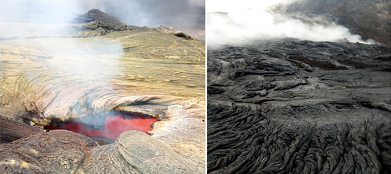 |
Figure 86. Photos of the summit crater of Nyamulagira during a field expedition on 29 September and 1 October 2020. Lava was visible in the crater, accompanied by white gas-and-steam emissions (left). Pahoehoe lava flows were also observed along the crater floor (right). Courtesy of OVG (Republique Democratique du Congo, Ministere de la Recherche Scientifique, Observatoire Volcanologique de Goma, Direction Generale Goma, Rapport Trimestriel juillet - sptembre 2020). |
MIROVA (Middle InfraRed Observation of Volcanic Activity) analysis of MODIS satellite data showed frequent thermal anomalies of variable intensities during December 2020 through May 2021 (figure 87). A pulse of strong thermal activity was detected during late December through mid-January, following a brief break in activity. A total of 31 thermal hotspots identified by MODVOLC were located in the active summit crater on 12 different days: 10, 28, 29, and 31 December 2020; 4, 7, 9, and 22 January; 28 February; 22 April; and 3 and 31 May 2021. The strong thermal activity in late December is also reflected in the MODVOLC algorithm on 28 December with a high hotspot count of twelve. On clear weather days, Sentinel-2 thermal satellite imagery also showed thermal anomalies within the summit crater originating from the NE and SW areas, with an intense anomaly in the SW portion on 22 January (figure 88). In February, both anomalies had decreased in power and on 27 April a thin band of thermal anomalies lined the perimeter of the crater.
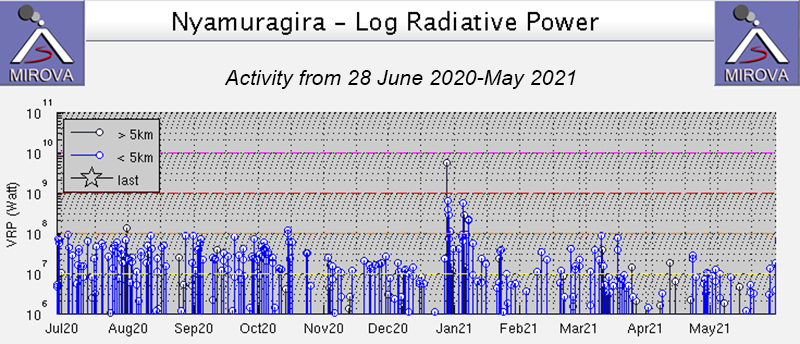 |
Figure 87. Frequent thermal anomalies at Nyamulagira during December 2020 through May 2021 were of variable intensity, according to the MIROVA graph (Log Radiative Power). A brief break in thermal activity was detected during mid-December, followed by a pulse of stronger anomalies recorded for this reporting period during late December through mid-January. A period of low-intensity anomalies was detected during late March through mid-April. Courtesy of MIROVA. |
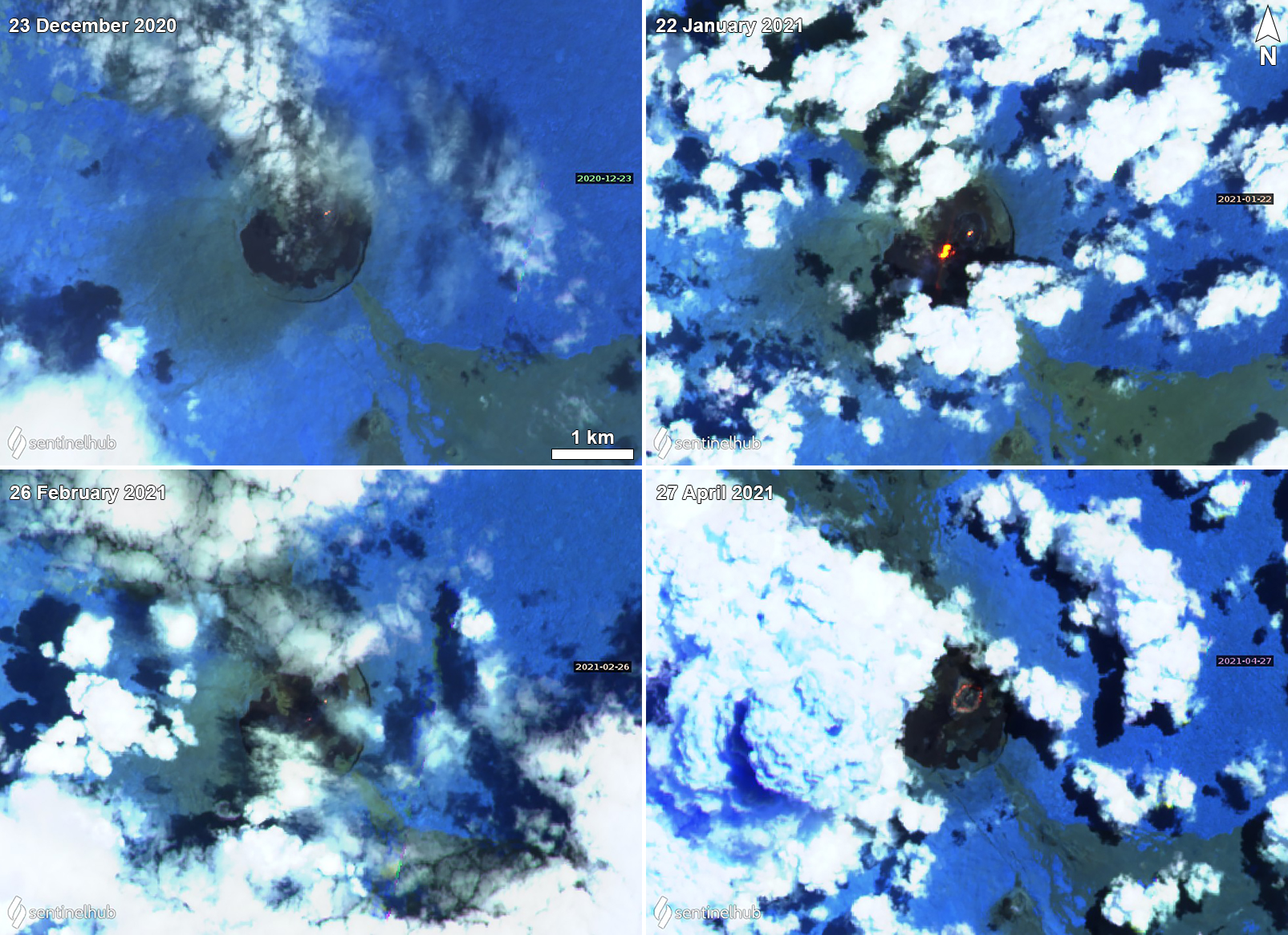 |
Figure 88. Sentinel-2 thermal satellite images showing an initial thermal anomaly (bright yellow-orange) in the NE part of the summit crater at Nyamulagira on 23 December 2020 (top left). On 22 January 2021 (top right) two thermal anomalies were observed, one in the NE and one in SW section of the crater, the latter of which was more intense. On 26 February (bottom left) both the thermal anomalies decreased in strength but were still visible in their respective parts of the summit crater. Finally, on 27 April (bottom right) a thin band of thermal activity lined the perimeter of the crater. Sentinel-2 satellite images with “Atmospheric penetration” (bands 12, 11, 8A) rendering. Courtesy of Sentinel Hub Playground. |
Geological Summary. Africa's most active volcano, Nyamulagira (also known as Nyamuragira), is a massive high-potassium basaltic shield about 25 km N of Lake Kivu and 13 km NNW of the steep-sided Nyiragongo volcano. The summit is truncated by a small 2 x 2.3 km caldera that has walls up to about 100 m high. Documented eruptions have occurred within the summit caldera, as well as from the numerous flank fissures and cinder cones. A lava lake in the summit crater, active since at least 1921, drained in 1938, at the time of a major flank eruption. Recent lava flows extend down the flanks more than 30 km from the summit as far as Lake Kivu; extensive lava flows from this volcano have covered 1,500 km2 of the western branch of the East African Rift.
Information Contacts: Observatoire Volcanologique de Goma (OVG), Departement de Geophysique, Centre de Recherche en Sciences Naturelles, Lwiro, D.S. Bukavu, DR Congo; MIROVA (Middle InfraRed Observation of Volcanic Activity), a collaborative project between the Universities of Turin and Florence (Italy) supported by the Centre for Volcanic Risk of the Italian Civil Protection Department (URL: http://www.mirovaweb.it/); Hawai'i Institute of Geophysics and Planetology (HIGP) - MODVOLC Thermal Alerts System, School of Ocean and Earth Science and Technology (SOEST), Univ. of Hawai'i, 2525 Correa Road, Honolulu, HI 96822, USA (URL: http://modis.higp.hawaii.edu/); Sentinel Hub Playground (URL: https://www.sentinel-hub.com/explore/sentinel-playground).