Report on Kikai (Japan) — June 2021
Bulletin of the Global Volcanism Network, vol. 46, no. 6 (June 2021)
Managing Editor: Edward Venzke.
Edited by Kadie L. Bennis.
Kikai (Japan) Thermal activity and gas-and-steam plumes persist during November 2020-April 2021
Please cite this report as:
Global Volcanism Program, 2021. Report on Kikai (Japan) (Bennis, K.L., and Venzke, E., eds.). Bulletin of the Global Volcanism Network, 46:6. Smithsonian Institution. https://doi.org/10.5479/si.GVP.BGVN202106-282060
Kikai
Japan
30.793°N, 130.305°E; summit elev. 704 m
All times are local (unless otherwise noted)
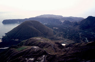
Kikai is located just S of the Ryukyu islands of Japan and contains a 19-km-wide mostly submarine caldera. The island of Satsuma Iwo Jima (also known as Satsuma-Iwo Jima and Tokara Iojima) is located at the NW caldera rim, as well as the island’s highest peak, Iodake. Its previous eruption period occurred on 6 October 2020 and was characterized by an explosion and thermal anomalies in the crater (BGVN 45:11). This report updates information from November 2020 through April 2021 using information from the Japan Meteorological Agency (JMA) and various satellite data. During this time, the Alert Level remained at a 2 (on a 5-level scale), according to JMA.
Activity during the reporting period was relatively low and primarily consisted of faint nighttime incandescence and occasional white gas-and-steam emissions (figure 21). During November 2020 incandescence was observed at night with a high-sensitivity surveillance camera and white gas-and-steam emissions rose to a high of 1 km above the crater on 2 November (figure 22). Sulfur dioxide measurements ranged from 900-1,200 tons/day, which was slightly higher than October (700 tons/day). The number of earthquakes detected during the month was 86, which was slightly lower than the previous month (97). Thermal activity continued in December accompanied by a white gas-and-steam plume that rose 1.2 km above the crater on 23 December (figure 23). The number of earthquakes had increased significantly to 265, as well as the SO2 flux to 800-1,900 tons/day.
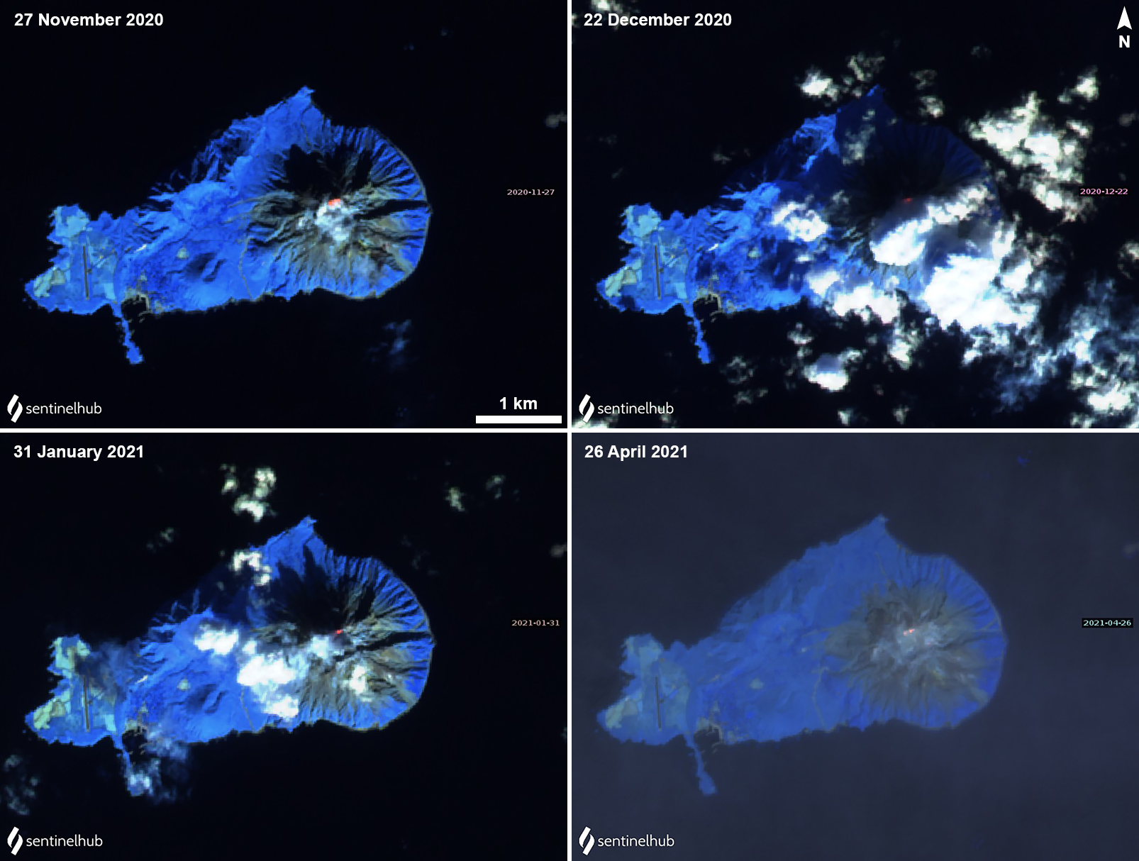 |
Figure 21. Intermittent weak thermal anomalies (yellow-orange) were observed at the summit of Satsuma Iwo Jima (Kikai) on 27 November (top left) 2020, 22 December (top right), 31 January (bottom left) 2021, and 26 April (bottom right). Sentinel-2 satellite images with “Atmospheric penetration” (bands 12, 11, 8A) rendering. Courtesy of Sentinel Hub Playground. |
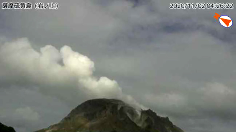 |
Figure 22. Webcam image of a white gas-and-steam plume rising 1 km above the crater at Satsuma Iwo Jima (Kikai) on 2 November 2020. Image taken by the Iwanoue webcam. Courtesy of JMA (An explanation of volcanic activity at Satsuma Iwo Jima, November 2nd year of Reiwa [2020]). |
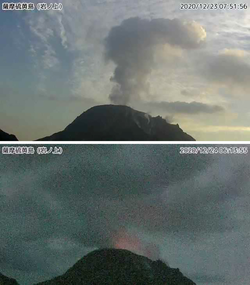 |
Figure 23. White gas-and-steam plume rose 1.2 km above the crater at Satsuma Iwo Jima (Kikai) on 23 December (top) 2020. At night, occasional incandescence could be seen in webcam images, as shown on 24 December (bottom). Both images taken by the Iwanoue webcam. Courtesy of JMA (An explanation of volcanic activity at Satsuma Iwo Jima, December 2nd year of Reiwa [2020]). |
Similar activity was reported in January 2021 with nighttime incandescence and a gas-and-steam plume that rose to a maximum height of 1.2 km above the Iodake crater that was recorded on 4 January. The SO2 flux was 300-1,800 tons/day. JMA reported some discoloration in the water at the coast near Iodake. There were 144 earthquakes recorded. White gas-and-steam emissions continued in February, rising up to 800 m above the crater on 24 February, as well as nighttime incandescence. The number of earthquakes had decreased slightly to 119 this month. SO2 measurements ranged 900-1,100 tons/day.
During March faint nighttime incandescence and seismicity continued; 145 earthquakes were detected. A white gas-and-steam plume rose to a high of 900 m above the crater on 15 March. The sulfur dioxide flux ranged from 500-1,200 tons/day, which was around a similar range as the previous month. In April, nighttime incandescence and earthquake events persisted; there was a slight increase in the number of earthquakes from 145 to 181. A white gas-and-steam plume rose 1.2 km above the crater on 8 April. Measurements of the SO2 flux were 800-900 tons/day during April.
Geological Summary. Multiple eruption centers have exhibited recent activity at Kikai, a mostly submerged, 19-km-wide caldera near the northern end of the Ryukyu Islands south of Kyushu. It was the source of one of the world's largest Holocene eruptions about 6,300 years ago when rhyolitic pyroclastic flows traveled across the sea for a total distance of 100 km to southern Kyushu, and ashfall reached the northern Japanese island of Hokkaido. The eruption devastated southern and central Kyushu, which remained uninhabited for several centuries. Post-caldera eruptions formed Iodake (or Iwo-dake) lava dome and Inamuradake scoria cone, as well as submarine lava domes. Recorded eruptions have occurred at or near Satsuma-Iojima (also known as Tokara-Iojima), a small 3 x 6 km island forming part of the NW caldera rim. Showa-Iojima lava dome (also known as Iojima-Shinto), a small island 2 km E of Satsuma-Iojima, was formed during submarine eruptions in 1934 and 1935. Mild-to-moderate explosive eruptions have occurred during the past few decades from Iodake, a rhyolitic lava dome at the eastern end of Satsuma-Iojima.
Information Contacts: Japan Meteorological Agency (JMA), Otemachi, 1-3-4, Chiyoda-ku Tokyo 100-8122, Japan (URL: http://www.jma.go.jp/jma/indexe.html); Sentinel Hub Playground (URL: https://www.sentinel-hub.com/explore/sentinel-playground).