Report on Semisopochnoi (United States) — June 2021
Bulletin of the Global Volcanism Network, vol. 46, no. 6 (June 2021)
Managing Editor: Edward Venzke.
Edited by Janine B. Krippner.
Semisopochnoi (United States) Ash emissions in June 2020 and during February-May 2021
Please cite this report as:
Global Volcanism Program, 2021. Report on Semisopochnoi (United States) (Krippner, J.B., and Venzke, E., eds.). Bulletin of the Global Volcanism Network, 46:6. Smithsonian Institution. https://doi.org/10.5479/si.GVP.BGVN202106-311060
Semisopochnoi
United States
51.93°N, 179.58°E; summit elev. 1221 m
All times are local (unless otherwise noted)
The volcanic Semisopochnoi Island in the western Aleutian Islands contains a group of cones within a caldera complex (figure 5). The active Cerberus center has three summit craters, with the current activity originating from North Cerberus. Since September 2018, typical activity has produced minor ash deposits within the vicinity. This bulletin summarizes activity that occurred from April 2020 through May 2021 based on information given by the Alaska Volcano Observatory (AVO), supplemented by satellite data.
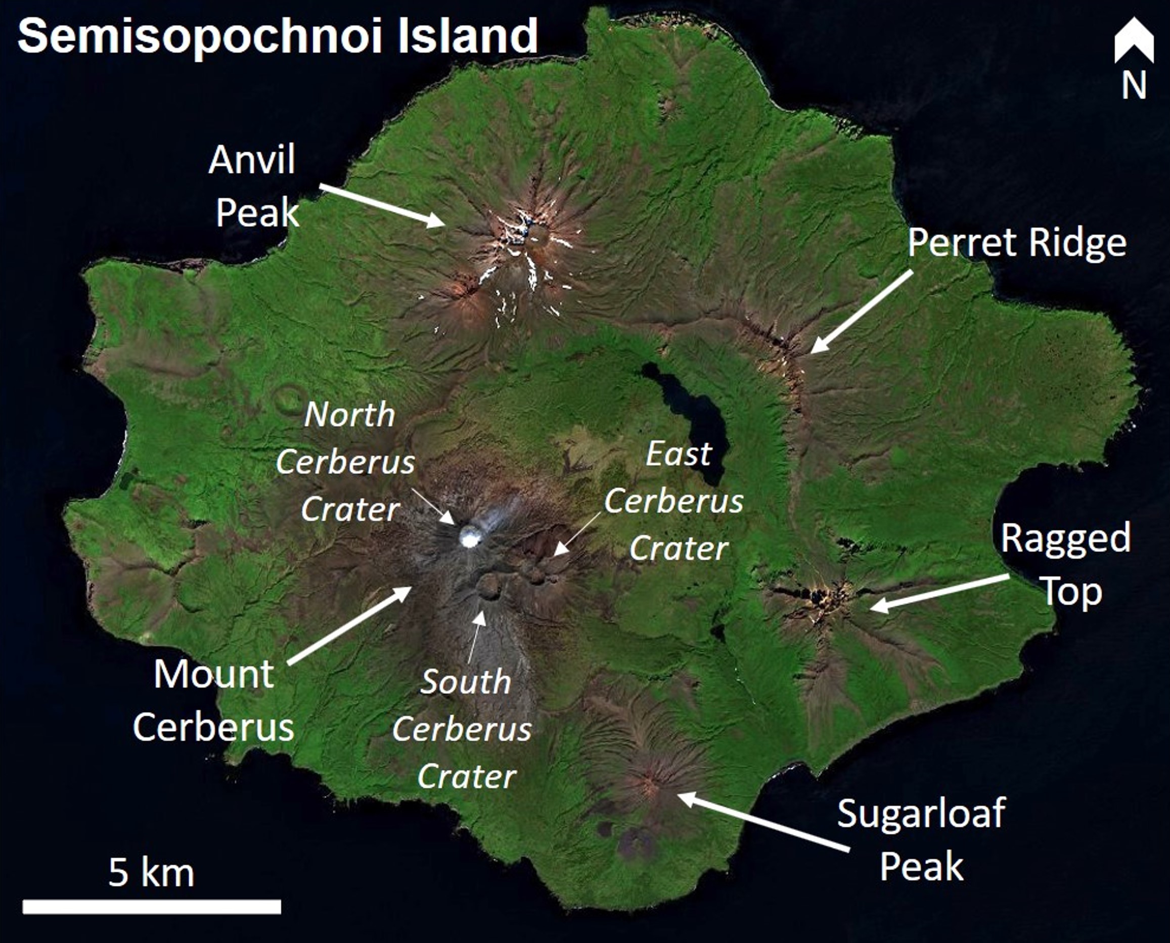 |
Figure 5. This satellite image of Semisopochnoi Island, Alaska, shows the major surface features with an 8-km-wide caldera in the center. As of 2021, Mount Cerberus is the most active of three cones within the caldera complex. The North, East, and South Cerberus craters are indicated, with a faint gas plume dispersing NE from the active North crater on 22 August 2020. Base satellite image from Sentinel-2 using Natural color (bands 4, 3, 2) rendering. Courtesy of Sentinel Hub Playground. |
Intermittent small explosions occurred at Semisopochnoi during early 2020. An AVO Volcano Activity Notice for Aviation (VONA) issued on 1 April reported no indication of activity over the previous two weeks and seismicity at background levels. Satellite data show detectable sulfur dioxide (SO2) emission and visible steam plumes. Low-level unrest continued into early June with occasional small earthquakes, including a few small low-frequency events and episodic tremor, occasional steam plumes, and detectable SO2 emissions. An increase in tremor was detected around 12-13 June, and infrasound and seismicity indicated rapid degassing events on 17 and 19 June, with activity declining again by the 20th. AVO noted that clear satellite images acquired on the 21st showed minor ash deposits near the crater, likely from the elevated activity during the previous week, and vigorous gas and steam emission (figure 6). Steam and gas emission continued through to the end of the month then intermittently through July. A 200-km-long SO2 plume was detected on 15 July and low-level unrest continued.
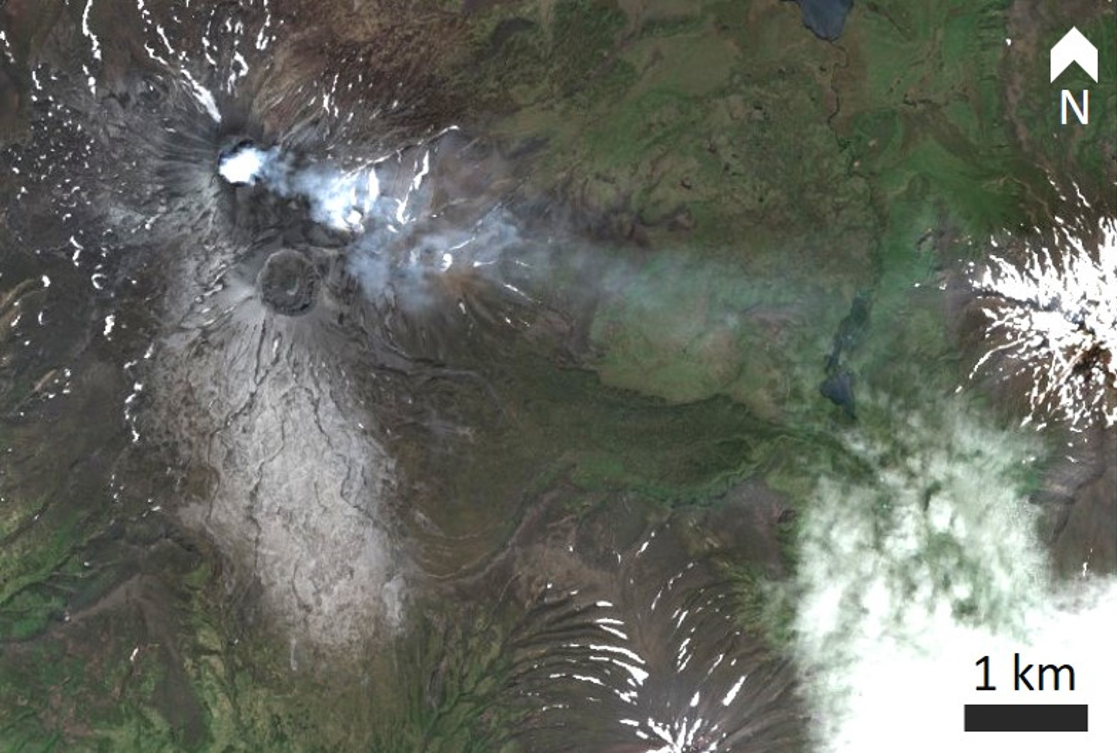 |
Figure 6. Minor ash deposits are visible on the Semisopochnoi North Cerberus Crater and a steam plume is shown dispersing ESE on 21 June 2020. Sentinel-2 satellite image with Natural color (bands 4, 3, 2) rendering. Courtesy of Sentinel Hub Playground. |
A gas plume was reported on 7 August and seismicity was above background to the 9th, after that seismicity was at very low levels with no more significant events detected. Infrequent small earthquakes were detected through September and minor steam emissions on the 22nd. Seismicity remained low throughout October. No eruptive activity had detected since mid-June and seismicity had declined to very low levels prior to seismic data transmission failing on 11 November. Due to the lack of data, on 20 November the Aviation Color Code and Alert Level were reduced to Unassigned.
There were no reports of activity during December 2020 or January 2021. A satellite image acquired on 7 February showed several small ash deposits extending at least 3 km from the North Cerberus Crater, likely produced by a small explosion the previous week (figure 7). Steam emission prevented views into the crater and clouds obscured the volcano over the following week.
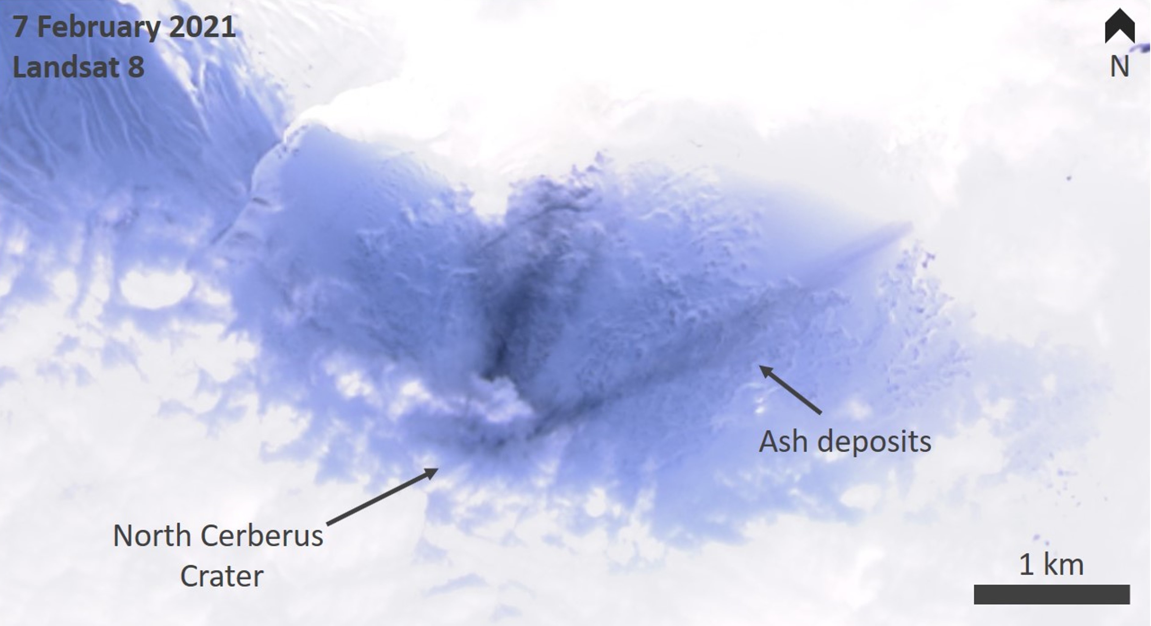 |
Figure 7. This Landsat 8 image acquired on 7 February 2021 at Semisopochnoi shows several linear ash deposits from the North Cerberus Crater. This reflects low-level explosive activity. Landsat 9 true Color – pansharpened scene. Courtesy of Sentinel Hub Playground. |
On 10 March a satellite image revealed a recently emplaced ash deposit that extended 1.5 km from the crater, with a steam plume being blown to the E (figure 8). Several similar small ash deposits had been noted by AVO in the previous weeks. No activity was observed or detected through 18 March, other than a possible gas plume that day. At 0350 on the 19th a small explosion was detected by infrasound monitoring. Another small explosion was detected at 0230 on the 21st, followed by a series of smaller explosions. During 22-23 March three explosions were detected. Cloud cover prevented visual observation of these events, but possible SO2 plumes were detected and a confirmed plume on the 23rd indicated further unrest. A probable ash deposit and plume were imaged on the 24th (figure 9). Activity continued with intermittent explosions and SO2 plumes detected through the 27th.
 |
Figure 8. This 10 March 2021 WorldView-3 satellite image shows ash deposits from low-level explosive activity at the Cerberus North Crater at Semisopochnoi. The ash extends to 1.5 km from the vent and has been partly remobilized by wind. A plume emanating from the crater is being blown to the E. Figure by Hannah Dietterich, courtesy of AVO. |
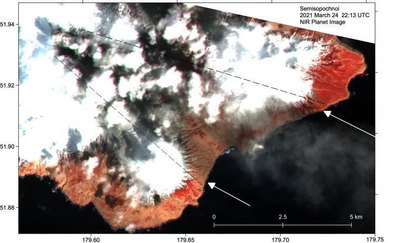 |
Figure 9. An ash deposit is present between the dashed lines, deposited on snow (red) in this Planet Labs near-IR false color satellite image acquired on 24 March 2021. The deposit extends over 8 km ESE across Semisopochnoi from the North Cerberus Crater and a plume is also visible in the same area. Image courtesy of AVO. |
Several small low-altitude ash and gas plumes were detected in satellite images on 30 March and 1 April. Cloud cover prevented satellite views until 12 April, when new ash deposits and low-level ash emissions were observed extending at least to the coastline, accompanied by weak infrasound signals. Low-level activity was also detected the following day. Sustained ash emission that began on the morning of the 15th (figure 10) produced a plume extending more than 350 km E to altitudes of 6 km; activity continued through the next day with a change in direction to the N at around 3 km altitude. Ash emission continued over the following days with a VONA released on the 22nd reporting an ash plume reaching 3 km and extending about 75 km S (figure 11). Through to the end of April ash and SO2 plumes were either observed or noted as probably occurring under cloudy conditions.
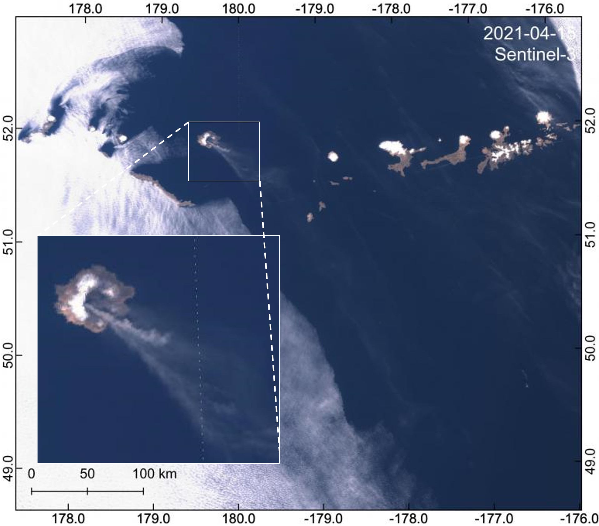 |
Figure 10. This Sentinel-3 satellite scene acquired on 15 April 2021 shows plumes from Semisopochnoi dispersed over 330 km from the vent. The insert shows a zoomed-in view of the island and the proximal ash plume. Original image by Hannah Dietterich, AVO. |
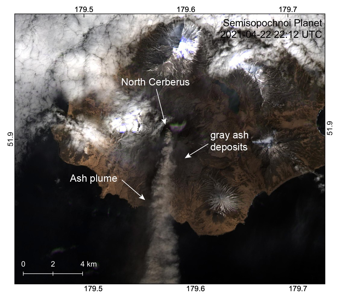 |
Figure 11. This Planet Labs satellite image acquired on 22 April 2021 shows an ash plume produced by the North Cerberus Crater and dispersing S. Ash deposits are visible on the flanks of the cone. Figure by Hannah Dietterich, AVO. |
The volcano was often obscured during the first week of May, with activity possibly continuing at a low level without detection. A gas plume was detected on the 11th, and an ash plume is visible in satellite images acquired on the 17th (figure 12). Small explosions and SO2 emissions were detected through 21 May. An ash emission reaching 3 km altitude that was seen by an AVO field crew on 29 May was also observed in satellite data moving SW. Elevated temperatures were detected in the North Cerberus Crater. Ash emissions were produced again on the 30th and observed by an AVO field crew (figure 13). Seismic data transmission was restored on 26 May.
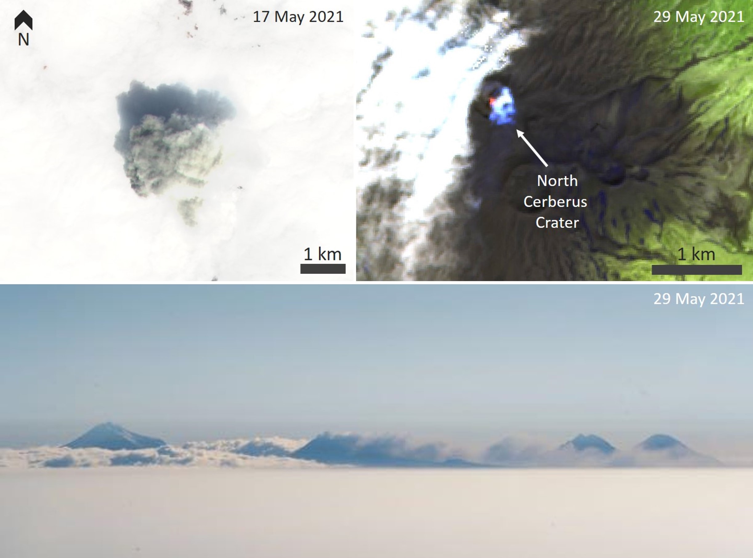 |
Figure 12. Satellite images of Semisopochnoi acquired on 17 and 29 May (top), and a photograph taken on 29 May 2021 (bottom) show weak activity at the North Cerberus Crater, including ash emission, gas emission, and elevated temperature on the crater floor. Sentinel-2 color infrared (vegetation, bands 8, 3, 4) scene at the top left and the false color (urban, bands 12, 11, 4) scene at the top right courtesy of Sentinel Hub Playground. Photo courtesy of Hannah Dietterich, AVO. |
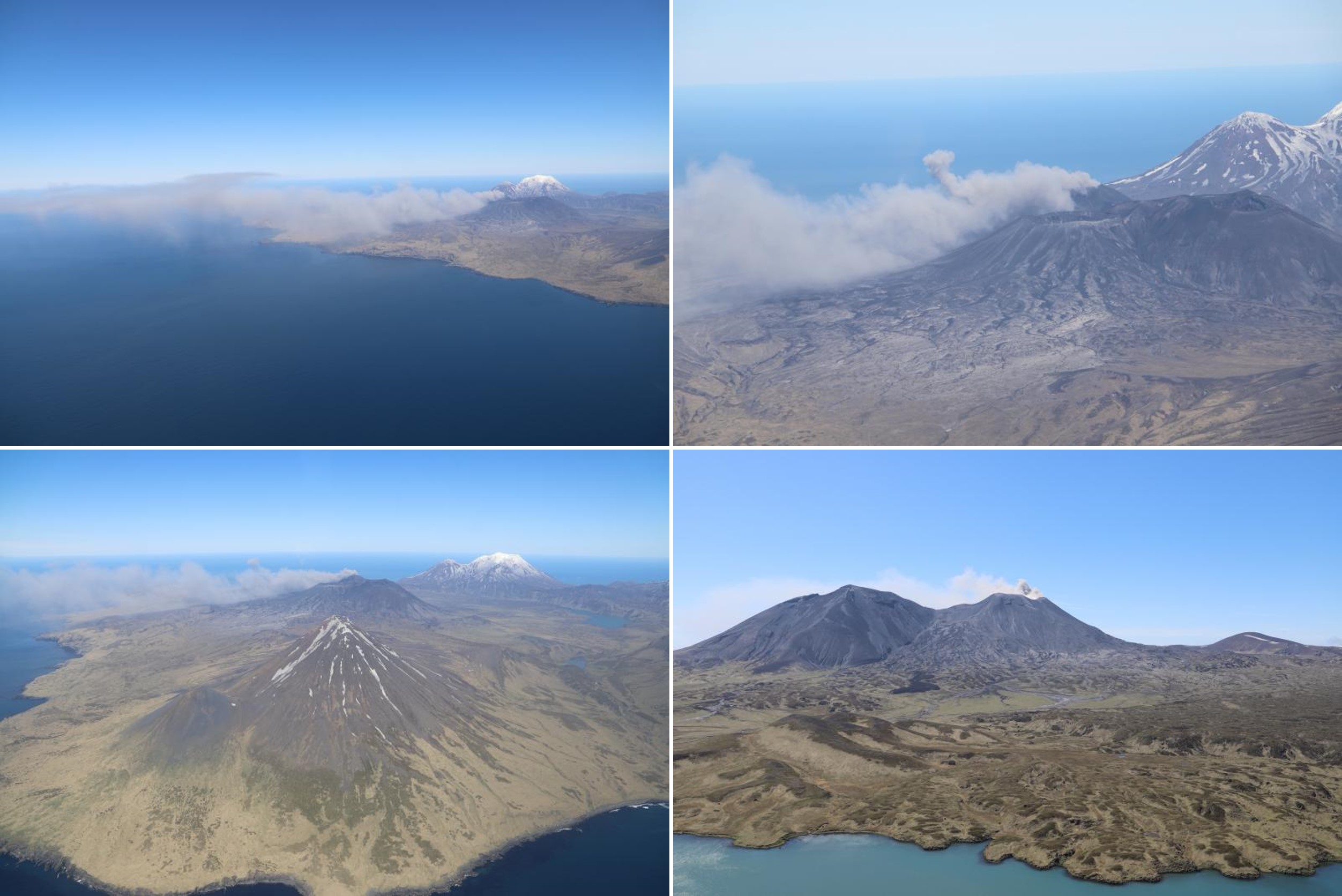 |
Figure 13. Minor ash emissions produced on 30 May 2021 at Semisopochnoi’s North Cerberus Crater around 1320 local time, taken from a helicopter during field work. Both top and bottom-left photos are taken from the SE. Photos courtesy of Hannah Dietterich, AVO. |
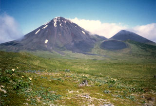
Geological Summary. Semisopochnoi, the largest subaerial volcano of the western Aleutians, is 20 km wide at sea level and contains an 8-km-wide caldera. It formed as a result of collapse of a low-angle, dominantly basaltic volcano following the eruption of a large volume of dacitic pumice. The high point of the island is Anvil Peak, a double-peaked late-Pleistocene cone that forms much of the island's northern part. The three-peaked Mount Cerberus (renamed Mount Young in 2023) was constructed within the caldera during the Holocene. Each of the peaks contains a summit crater; lava flows on the N flank appear younger than those on the south side. Other post-caldera volcanoes include the symmetrical Sugarloaf Peak SSE of the caldera and Lakeshore Cone, a small cinder cone at the edge of Fenner Lake in the NE part of the caldera. Most documented eruptions have originated from Young, although Coats (1950) considered that both Sugarloaf and Lakeshore Cone could have been recently active.
Information Contacts: Alaska Volcano Observatory (AVO), a cooperative program of a) U.S. Geological Survey, 4200 University Drive, Anchorage, AK 99508-4667 USA (URL: https://avo.alaska.edu/), b) Geophysical Institute, University of Alaska, PO Box 757320, Fairbanks, AK 99775-7320, USA, and c) Alaska Division of Geological & Geophysical Surveys, 794 University Ave., Suite 200, Fairbanks, AK 99709, USA (URL: http://dggs.alaska.gov/); Global Sulfur Dioxide Monitoring Page, Atmospheric Chemistry and Dynamics Laboratory, NASA Goddard Space Flight Center (NASA/GSFC), 8800 Greenbelt Road, Goddard, Maryland, USA (URL: https://so2.gsfc.nasa.gov/); Sentinel Hub Playground (URL: https://www.sentinel-hub.com/explore/sentinel-playground); Planet Labs, Inc. (URL: https://www.planet.com/).