Pacaya
Guatemala
14.382°N, 90.601°W; summit elev. 2569 m
All times are local (unless otherwise noted)
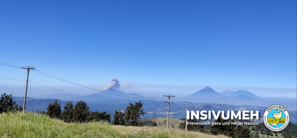
Extensive lava flows, bomb-laden Strombolian explosions, and ash plumes from Mackenney crater have characterized the persistent activity at Pacaya since 1961. The latest eruptive period began with intermittent ash plumes and incandescence in June 2015; the growth of a new pyroclastic cone inside the summit crater was confirmed later that year and has continued, producing frequent loud Strombolian explosions rising above the crater rim and ongoing ash emissions. In addition, flank fissures have been the source of lava flows during 2019-2021. A significant increase in both effusive and explosive activity that began in February 2021 continued through mid-May. Activity during March-May 2021 is covered in this report with information provided by Guatemala's Instituto Nacional de Sismologia, Vulcanologia, Meteorologia e Hydrologia (INSIVUMEH), multiple sources of satellite data, and photographs from observers on the ground.
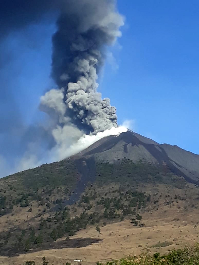
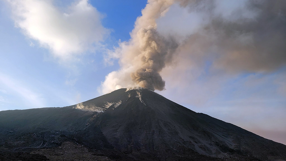
Summary of activity during March-May 2021. Incandescent explosions, ash emissions, and subsequent ashfall increased substantially at the beginning of March 2021 from the already increased levels during February. Explosions sent ejecta hundreds of meters high and hundreds of meters from the summit; ash plumes drifted tens to hundreds of kilometers and ashfall occurred almost daily in communities within tens of kilometers of Mackenney crater. The most extensive ash emissions forced closure of the International Airport in Guatemala City on 22 March. Ash emissions decreased during April and were intermittent into the first half of May, after which they tapered off.
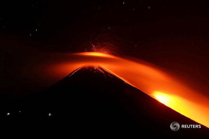
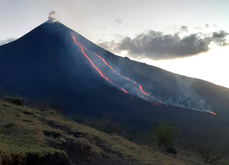
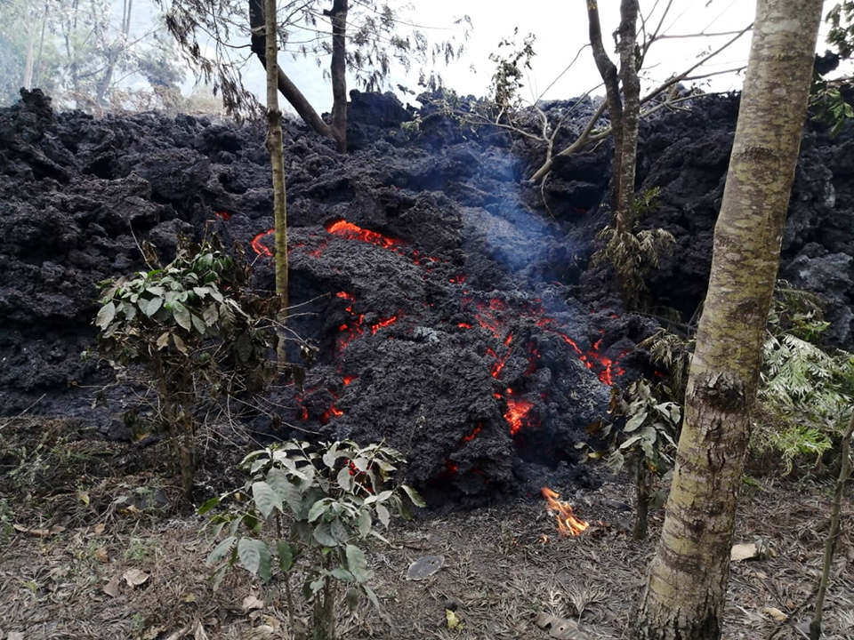
Effusive activity also increased significantly during March 2021; by early in the month as many as three lava flows with multiple branches, all about 1 km long, were simultaneously active on multiple flanks. A new fast-moving flow appeared on the SW flank during the second half of March and rapidly reached 1.5 km in length, flowing NW then SW, ultimately extending over 3 km. It had multiple branches that caused vegetation fires, destroyed significant cropland, and crossed roads before stopping in mid-April. A new flow emerged along a similar path at the end of April and grew to over 2 km long in early May before activity at its source fissure ended on 17 May. High temperatures remained at many flow areas around the volcano for the rest of the month.
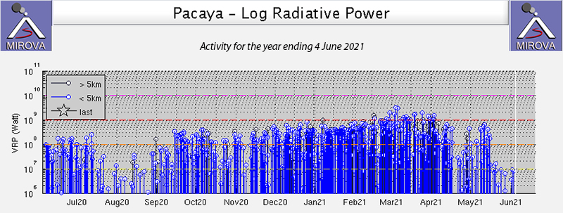
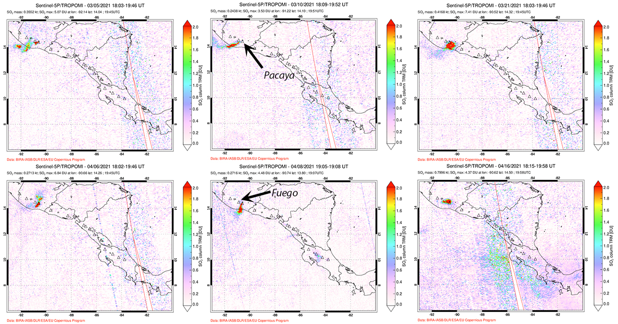
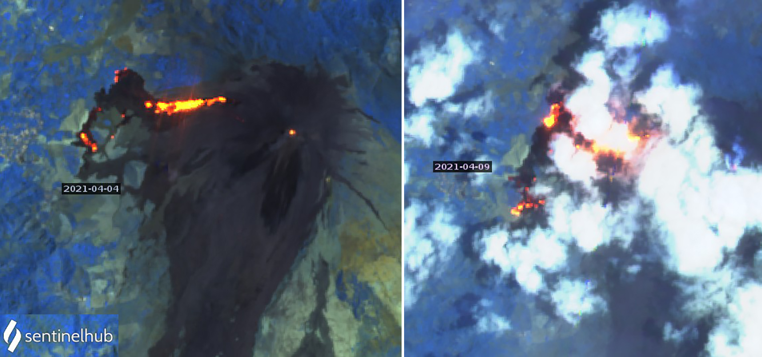
The high levels of activity are reflected in the MIROVA radiative power data for the period which show the increase in intensity to very high levels through mid-April, followed by a pulse in late April and early May that corresponds to explosions and lava flows. Thermal activity decreased significantly by the third week of May (figure 160). The MODVOLC thermal alert data shows a similar pattern with multiple alerts issued most days in March and for the first half of April, and another pulse of activity from 27 April-13 May. Significant sulfur dioxide emissions were recorded in satellite data several times in March and April and corresponded to periods of increased explosive and effusive activity (figure 161).
Activity during March 2021. A notable increase in seismicity early on 1 March 2021 coincided with increased Strombolian activity. Observatorio Volcán de Pacaya geologists observed explosions sending ejecta 500 m above the rim of Mackenney crater accompanied by plumes of ash and gas that reached 3.5 km altitude and drifted W and SW. For most of March high levels of Strombolian activity sent ejecta 200-400 m high each day, sometimes higher, reaching 800 m on 3 March, 800-1,000 m on 5 March, and 700 m on 10 March (figure 162). Sounds as loud as a train locomotive or plane engine from the explosions were frequently reported, and ejecta was sometimes scattered 500-600 m from the cone. Explosive activity with ejecta and ash emissions were also reported from the fissure feeding the lava flow on the S flank 300 m below Mackenney crater. On 14 March, ejecta from the fissure sent block avalanches 1,300 m down the S flank.
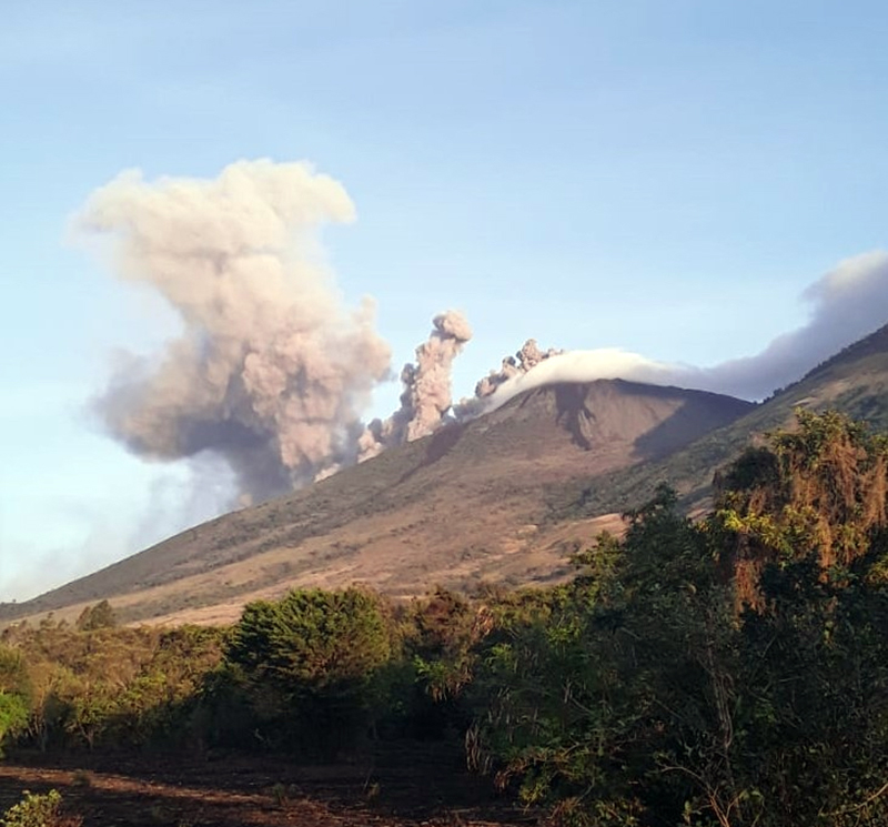
The increase in explosive activity also included an increase in dense ash emissions and resulting ashfall during March 2021. Ash plume heights ranged from 3 to 5.5 km altitude, and often drifted W, NW, or SW. The Washington VAAC reported an ash plume centered about 75 km WSW of the summit on 1 March. On 3 March a dense ash emission was drifting W from the summit at 3.7 km altitude. The next day ash was detected almost 100 km SW just off the Mexican Pacific coast before dissipating. The altitude of the ash emissions increased to 4.9 km on 5 March; puffs drifting W were visible in satellite images extending over 250 km from the summit the next day. Pulses of activity lasted between 15 minutes and 13 hours, and produced tephra fallout around the volcano, dense ash plumes that drifted 3-5 km, and finer ash plumes that drifted more than 60 km.
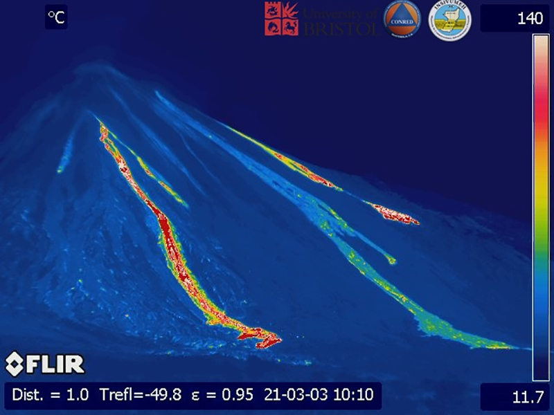
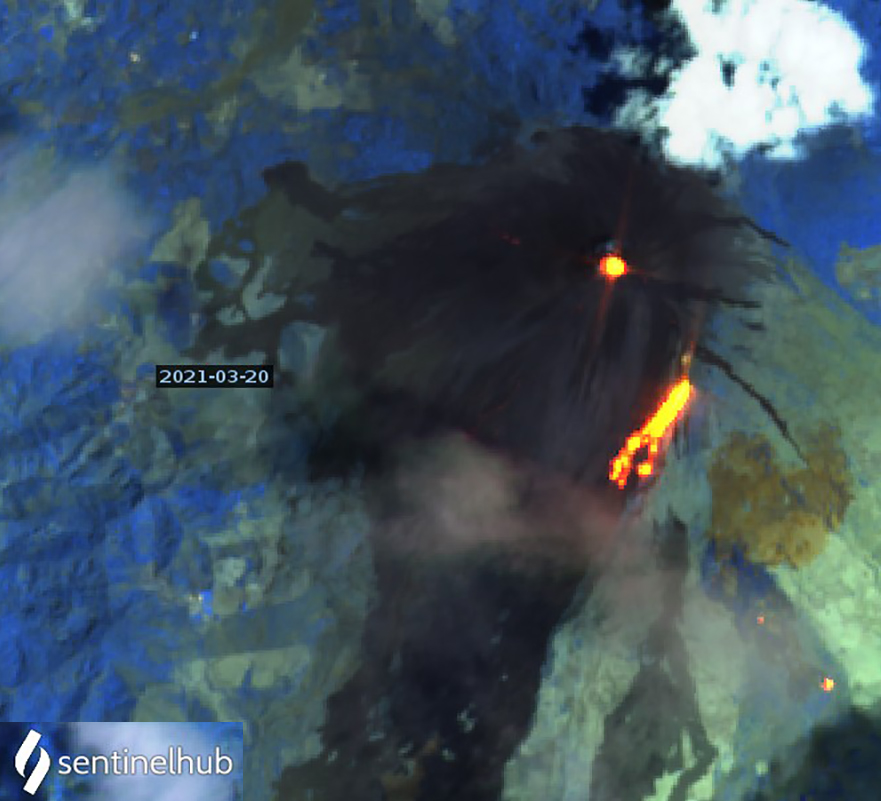
Explosions on 7 March caused lava fountains 100-500 m above the crater. The following day ash plumes were drifting 45 km SW at 3 km altitude. On 9 March ash plumes fanned out from the NW to the SW about 30 km from the summit before dissipating. From 11 March onward multiple daily discrete ash emissions extended at least 30-50 km WNW and SW from the summit at altitudes of 3.7-4.3 km altitude, and much farther on some days. The plumes reached 90 km WSW on 12 March, and 140 km W on 14 March. The next day, ash emissions extended over 100 km WSW, with remnants visible in satellite images almost 185 km away by the end of the day. On 16 March they drifted 170 km WNW at 4.3 km altitude and on 18 March the ash emissions were observed drifting SW at 3.4 km altitude extending 185 km from the summit. Dense gray-black emissions were accompanied by white steam emissions on 21 March (figure 163).
Dense ash clouds seen on 22 March 2021 were drifting rapidly SSE at 4.9 km altitude as far as 75 km, SE at 6.1 km altitude, and visible in satellite imagery moving E at 7.6 km altitude up to 25 km from the volcano. The next day they were drifting NE at 3 km altitude up to 90 km away, and SW at 4.6 km altitude. A narrow ash plume was detected in visible satellite imagery on 28 March drifting about 80 km NW of the summit before dissipating. Over the next two days a plume was detected moving SW at 3 km altitude about 130-150 km from the summit. In addition, another plume was drifting NW at 4.3 km altitude on 31 March causing dense ash to cover the summit of Fuego that was visible on webcams. The lower plume was visible over 300 km SW of Pacaya before it dissipated (figure 164).
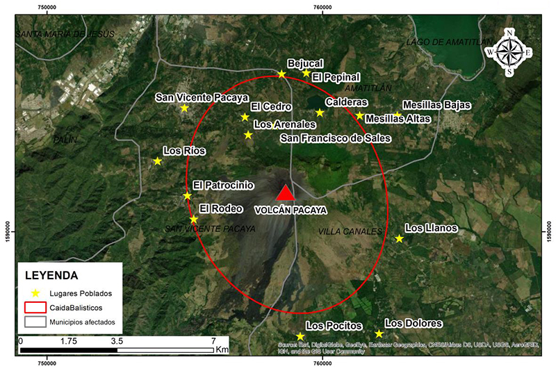
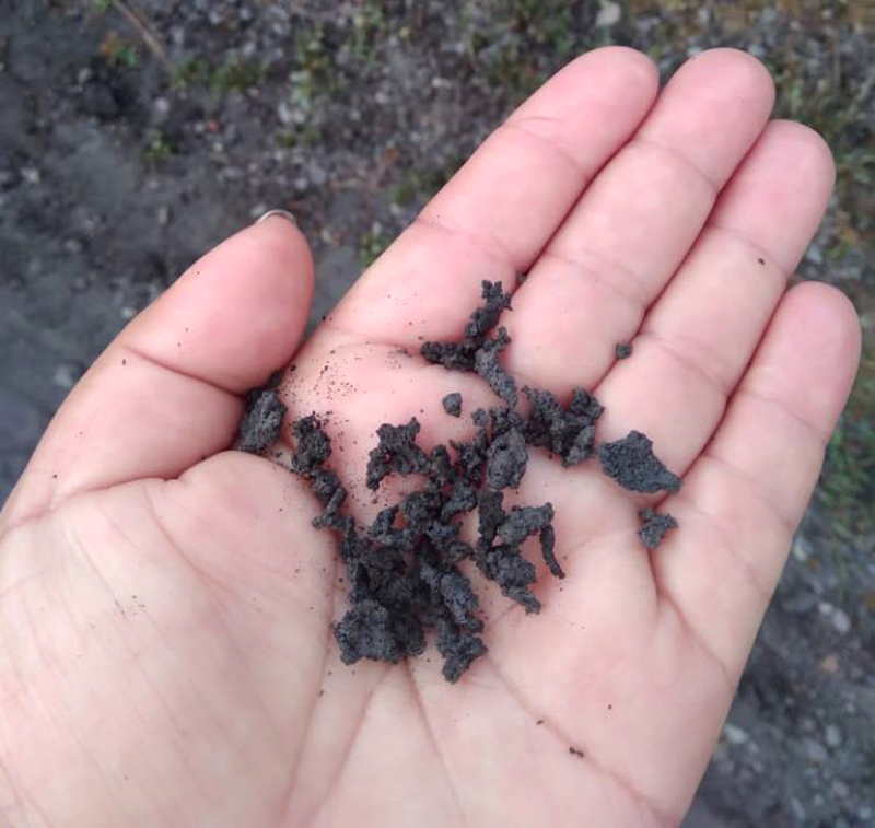
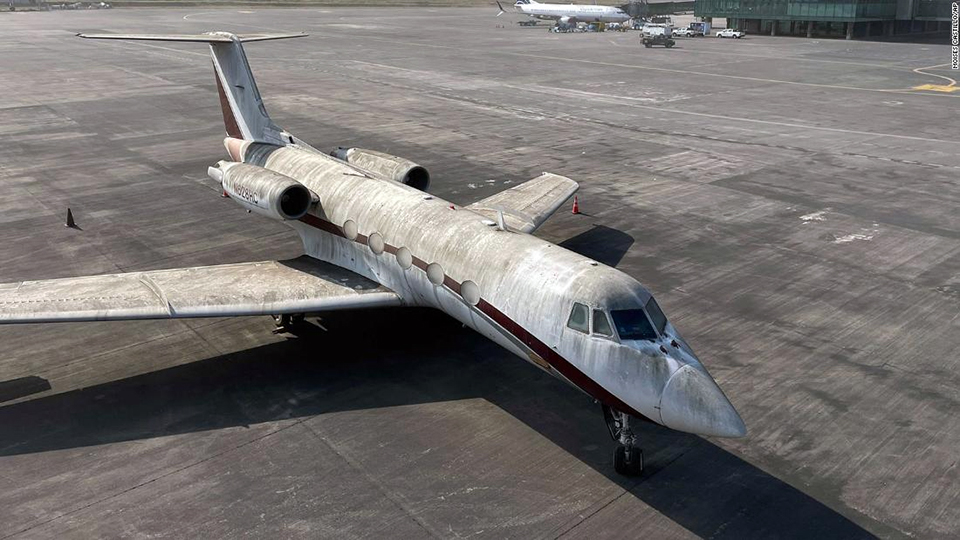
Communities all around Pacaya were affected by ashfall many times throughout March 2021 (figure 165, table 7). Most of the communities were within 10 km of the summit, but ashfall reached more than 20 km away multiple times. During the bigger ashfall events, blocks more than 6 cm in diameter fell on the flanks of the volcano, while lapilli (2 mm to 6 cm) fell up to 5 km away, and fine ash was observed up to 30 km away (figure 166). The most significant ashfall events occurred during 22-23 March when ash drifted tens of kilometers in multiple directions and caused the closure of La Aurora International Airport in Guatemala City (figure 167).
Table 7. Communities reporting ashfall from Pacaya during March 2021. Information courtesy of INSIVUMEH.
| Date |
Direction |
Tephra Description |
Community |
| 01 Mar 2021 |
SW |
Ash |
El Patrocinio and others in that direction. |
| 03 Mar 2021 |
SW |
Ash |
El Patrocinio and El Rodeo, SW flank. |
| 05 Mar 2021 |
SW |
Ash, lapilli (2 mm to 6 cm) and blocks greater than 6 cm |
San Francisco de Sales, Cerro Chino, El Cedro, El Patrocinio and El Rodeo, ash in Los Rios and Los Jazmines communities, and in the municipalities of Palín (10 km WNW) and Escuintla (20 km SW). |
| 06 Mar 2021 |
W, S |
Ash |
El Patrocinio and El Rodeo, SW flank. |
| 08 Mar 2021 |
SW, S, SE |
Ash |
Pacaya village, El Chupadero farm, La Laguna farm and others in this area. |
| 10 Mar 2021 |
W, SW |
Coarse ash and lapilli |
El Patrocinio, El Caracol. |
| 11 Mar 2021 |
W, SW |
Ash |
El Patrocinio and San José El Rodeo in the municipality of San Vicente Pacaya. |
| 14 Mar 2021 |
W, SW, NW |
Ash |
San José el Bejucal, San Antonio el Pepinal, San Francisco de Sales, Concepción el Cedro, San José Calderas, fine ash in the municipalities of Amatitlán (10 km N), Villa Nueva (15 km N), Mixco (30 km NNE) and the Capital city (25 km NNE). |
| 15 Mar 2021 |
W, NW |
Ash |
Communities on the NW, W, SW flanks. |
| 16 Mar 2021 |
NW, W |
Ash, Lapilli |
Fine ash to 2 cm long lapilli in El Patrocinio, San José El Rodeo and Concepción El Cedro, in the municipality of San Vicente Pacaya. Fine ash in the urban area of Amatitlán. |
| 17 Mar 2021 |
SW, W, NW, N |
Ash |
El Rodeo, El Patrocinio, El Cedro, San Francisco de Sales, Amatitlán, Villa Nueva. |
| 18 Mar 2021 |
S, SW |
Ash |
El Rodeo, El Patrocinio, Los Pocitos and others in these directions. |
| 22 Mar 2021 |
E, SE, S, SW |
Ash |
El Rodeo, El Patrocinio, Los Pocitos, Los Dolores, Los Llanos, Santa Elena Barillas, Mesías Alta and Mesías Baja. |
| 23 Mar 2021 |
S, NE |
Lapilli, ash |
Lapilli in San Francisco de Sales and San José Calderas. Ash reported in El Cedro, San Francisco de Sales, Mesías Bajas, Mesías Altas, Los Pocitos, Los Dolores, Santa Elena Barillas, and also Villa Nueva and the Capital Guatemala City. La Aurora International Airport (25 km NNE) closed. |
| 24 Mar 2021 |
NE |
Ash |
Mesillas Altas and Mesillas Bajas. |
| 25 Mar 2021 |
W, NW, NE, N |
Ash |
San Francisco de Sales, San Vicente Pacaya, Pepinal, El Cedro, Calderas, Mesías Alta, and Messías Baja. |
| 26 Mar 2021 |
SW |
Ash |
El Rodeo and El Patrocinio. |
| 27 Mar 2021 |
S |
Ash |
El Rodeo, El Patrocinio, Cedro, San Vicente Pacaya, and others in that area. |
| 28 Mar 2021 |
S, SW |
Ash |
El Patrocinio. |
| 30 Mar 2021 |
S |
Ash |
Communities on S flank including Finca El Chupadero and Los Pocitos. |
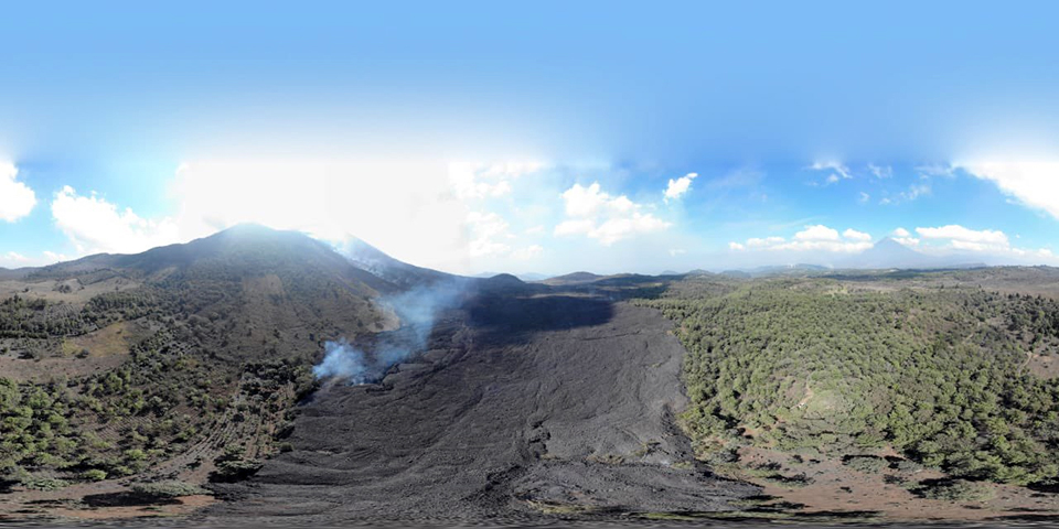
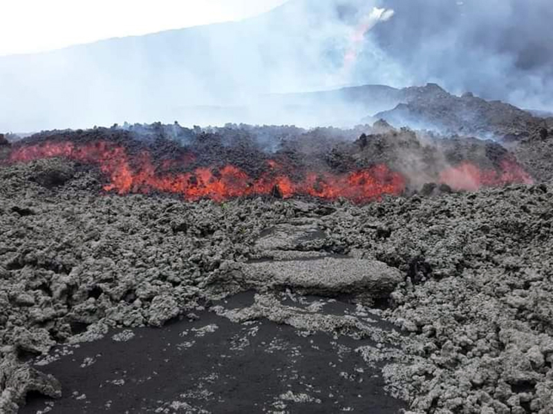
Lava flow activity also increased significantly during March 2021. At the end of February, an active flow on the S flank remained about 1 km long, shedding incandescent blocks hundreds of meters from its advancing front. By 3 March, three flows with multiple branches were active on the SSW flank; they were 800-1,000 m long (figure 168). On 5 and 6 March two flows with many branches extended 300-500 m down the S flank (figure 169). Flows were active on the SW, S, and SE flanks on 7 March. The S-flank-flow with two branches reached 1 km long by 8 March and had incandescent blocks constantly falling of the leading edge. It increased steadily in length, reaching 1.8 km by 16 March (figure 170).
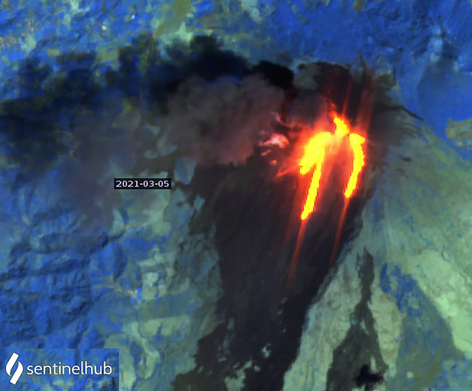
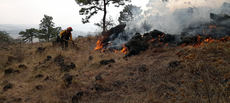
Two new flows emerged from the S and SE flanks on the morning of 18 March (figure 171). The S-flank flow grew to 500 m and part of it overflowed outside the plateau. The SE-flank flow was 400 m long in front of the village of Los Llanos, causing fires in the vegetation which continued for several days (figure 172). On 20 March the SE flank flow caused a strong thermal signature in satellite imagery with incandescent blocks falling downslope far beyond the front (figure 173). During the night of 20-21 March, a new flow appeared on the SW flank and grew to 500 m long; the flow on the SE flank reached 850 m. The following day the rapidly growing SW-flank-flow reached 1,500 m long, causing vegetation fires on ranches in Las Granadillas.
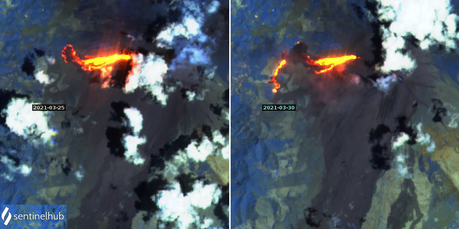
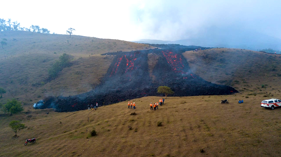
Three flows were active on 22 March 2021, with existing flows on the SW (1,500 m) and SE flanks (300 m), and a new flow on the E (500 m) flank. By 25 March activity was focused on the SW-flank flow which had reached 2.5 km in length (figure 174). It was about 400 m wide and 2.5 m high, burning vegetation as it advanced, and causing damage on coffee and avocado plantations. By 31 March the flow exceeded 3 km in length with multiple active fronts. One of the flow fronts near the community of La Breña was still advancing, but the one at the Campo Alegre farm had stopped moving. The flow continued to cause fires, destroy crops and buildings, and block roads (figure 175).
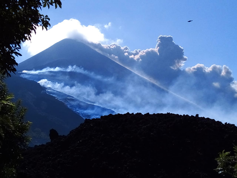
Activity during April 2021. On 1 April 2021 remnant plumes from earlier ash emissions were moving SW over the Pacific about 400 km from the summit at 4.3 km altitude, while newer emissions were drifting S at 3.4 km altitude towards the coast. Continuous ash emissions were reported by the Washington VAAC through April 4 (figure 176) drifting tens of kilometers mostly SW at 3.5-4.5 km altitude. Ash drifted up to 20 km S and SW during the first week and caused frequent ashfall in communities on the SE, S, and SW flanks, with the most affected being Los Pocitos, El Rodeo, and El Patrocinio. A few moderate to strong explosions sent ejecta 100-500 m above the Mackenney crater. By 9 April ash emissions were more sporadic and tended to drift only 5-10 km SW, W, and NW, and no ashfall was reported. The VAAC reported occasional emissions observed in the webcam on 8 and 14 April. An ash plume was detected on 16 April moving NNW at 3.4 km altitude. Strombolian activity diminished and activity changed to primarily steam and gas plumes rising 200 m above the crater after this. A short episode of sporadic explosions during 24-29 April sent ejecta to 250 m above the crater, generated loud noises, and produced ash emissions that rose a few hundred meters and drifted several kilometers.
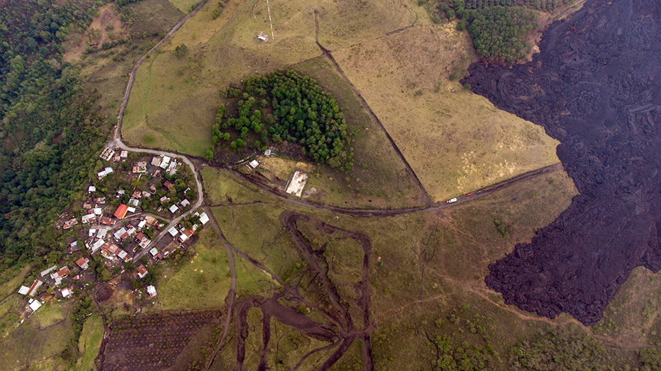
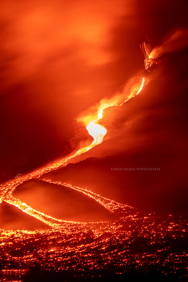
The SW-flank flow that began during 20-21 March remained active into early April and was 2.8-3 km long during the first week. It continued to advance during the second week and reached 3.7 km long with multiple active branches that were burning vegetation (figure 177). During 7-11 April it was advancing W and N in the area of La Breña and W and S in the area of El Patrocinio and El Rodeo on the Campo Alegre farm (figure 178). By 10 April this flow was 400 m from El Patrocinio and 250 m from San José El Rodeo. By 13 April it was burning avocado and coffee plantations 370 m from houses in El Patrocinio (figure 179). Another active front to the south was 250 m E of El Rodeo and had blocked the road between El Rodeo, El Caracol, and Los Pocitos. The seismic activity associated with the lava effusion decreased significantly beginning on 16 April.
During 18-20 April 2021 the branch near La Breña stopped advancing, and by 21 April the branch near El Patrocinio had stopped (figure 180), although temperatures remained high and gas emissions from vents along the flow continued in many places through the end of April. A lava flow appeared on the SE flank on 27 April, following a few days of renewed explosive activity, and grew to 175 m by 29 April. INSIVUMEH reported another new flow on the N flank on 29 April (figure 181); it advanced rapidly to the NW around Cerro Chino, and then turned towards the SW, reaching 1.6 km long by later in the day when the leading edge was located about 100 m from La Breña with several active flow fronts.
Activity during May 2021. Sporadic emissions of steam and gas with occasional ash were typical from Mackenney crater at the beginning of May 2021. Possible ash emissions were seen in satellite data on 1 May drifting W at 3.4 km altitude. Dense plumes, some with abundant ash, were reported on 8 May drifting W and S. Strombolian activity on 10 May from the NW-flank fissure was feeding the flow which began on 29 April; it sent ejecta 50-150 m high, and loud noises were heard. The Washington VAAC reported minor amounts of ash observed in satellite images moving SW from the summit during 10-13 May, when intermittent pulses of dense ash were reported drifting W and SW from the crater. Intermittent ash emissions rose to 3.7 km altitude on 14 May and were observed about 100 km SW before dissipating. Ash plumes drifted up to 5 km W on 15 and 16 May, causing ashfall during 16 and 17 May in El Patrocinio and El Rodeo (figure 182). During 18-21 May constant steam and gas, and periodic ash, emissions drifted 5-10 km NW and W at about 3 km altitude with ashfall reported in communities such as San Francisco de Sales, Concepción El Cedro, Aldea El Patrocinio, and San Miguel Petapa. For the remainder of May, small quantities of ash accompanied dense steam and gas emissions that rose 200-700 m above the summit and drifted W, SW, and S up to 5 km. El Patrocinio, El Rodeo, and other fincas in that area within 10 km reported ashfall on 26 May.
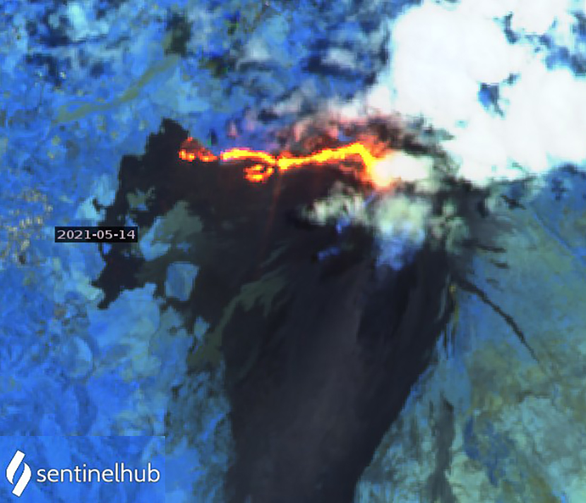
The N-flank flow that began on 29 April 2021 continued to advance into early May. It had originally flowed NW, then curved around Cerro Chino and headed W. It was 2 km long and advancing in the vicinity of La Breña on 3 May. On 5 May incandescent ejecta was observed at the fissure feeding the flow, which had advanced to the S of La Breña where incandescent blocks continued to fall off the front of the advancing flow. On 6 May the flow reached 2.3 km in length on the W flank, with only one of the fronts continuing to advance slowly. Small explosions were reported at the fissure. The lava flow continued to advance laterally in places as incandescent material spilled over the edges. Explosions from the fissure on 9 May threw material 15 m away as the flow continued moving slowly W (figure 183). By 11 May the flow was no longer advancing at its front but was still expanding due to overflows along its edges. Explosions from the fissure on 14 May launched ejecta 40 m (figure 184), and the flow front again moved slowly westward; by then it was about 2.3 km long (figure 185). Activity at the fissure ceased by 17 May.
Geological Summary. Eruptions from Pacaya are frequently visible from Guatemala City, the nation's capital. This complex basaltic volcano was constructed just outside the southern topographic rim of the 14 x 16 km Pleistocene Amatitlán caldera. A cluster of dacitic lava domes occupies the southern caldera floor. The post-caldera Pacaya massif includes the older Pacaya Viejo and Cerro Grande stratovolcanoes and the currently active Mackenney stratovolcano. Collapse of Pacaya Viejo between 600 and 1,500 years ago produced a debris-avalanche deposit that extends 25 km onto the Pacific coastal plain and left an arcuate scarp inside which the modern Pacaya volcano (Mackenney cone) grew. The NW-flank Cerro Chino crater was last active in the 19th century. During the past several decades, activity has consisted of frequent Strombolian eruptions with intermittent lava flow extrusion that has partially filled in the caldera moat and covered the flanks of Mackenney cone, punctuated by occasional larger explosive eruptions that partially destroy the summit.
Information Contacts: Instituto Nacional de Sismologia, Vulcanologia, Meteorologia e Hydrologia (INSIVUMEH), Unit of Volcanology, Geologic Department of Investigation and Services, 7a Av. 14-57, Zona 13, Guatemala City, Guatemala (URL: http://www.insivumeh.gob.gt/ ); Coordinadora Nacional para la Reducción de Desastres (CONRED), Av. Hincapié 21-72, Zona 13, Guatemala City, Guatemala (URL: http://conred.gob.gt/www/index.php, https://twitter.com/ConredGuatemala/status/1393207685756203011); Colred Los Llanos, Coordinadora local para la reduccion de desastres, Los Llanos, Villa Canales (URL: https://www.facebook.com/Colred-Los-Llanos-102105058094847); MIROVA (Middle InfraRed Observation of Volcanic Activity), a collaborative project between the Universities of Turin and Florence (Italy) supported by the Centre for Volcanic Risk of the Italian Civil Protection Department (URL: http://www.mirovaweb.it/); Hawai'i Institute of Geophysics and Planetology (HIGP) - MODVOLC Thermal Alerts System, School of Ocean and Earth Science and Technology (SOEST), Univ. of Hawai'i, 2525 Correa Road, Honolulu, HI 96822, USA (URL: http://modis.higp.hawaii.edu/); Washington Volcanic Ash Advisory Center (VAAC), Satellite Analysis Branch (SAB), NOAA/NESDIS OSPO, NOAA Science Center Room 401, 5200 Auth Rd, Camp Springs, MD 20746, USA (URL: www.ospo.noaa.gov/Products/atmosphere/vaac, archive at: http://www.ssd.noaa.gov/VAAC/archive.html); Sentinel Hub Playground (URL: https://www.sentinel-hub.com/explore/sentinel-playground); NASA Global Sulfur Dioxide Monitoring Page, Atmospheric Chemistry and Dynamics Laboratory, NASA Goddard Space Flight Center (NASA/GSFC), 8800 Greenbelt Road, Goddard, Maryland, USA (URL: https://so2.gsfc.nasa.gov/); Reuters Pictures (URL: https://twitter.com/reuterspictures/status/1367472450418704387); CNN (URL: https://www.cnn.com/2021/03/23/americas/guatemala-airport-volcano-closure-latam-intl/index.html); KTLA, (URL: https://ktla.com/news/nationworld/lava-from-guatemalas-pacaya-volcano-threatens-small-communities-that-live-nearby/); David Rojas, (URL: https://twitter.com/DavidRojasGt/status/1391592159221063680); Geo_Sci_Jerry (URL: https://twitter.com/SciJerry/status/1394083192773222406).