Report on Piton de la Fournaise (France) — July 2021

Bulletin of the Global Volcanism Network, vol. 46, no. 7 (July 2021)
Managing Editor: Edward Venzke.
Edited by Kadie L. Bennis.
Piton de la Fournaise (France) New eruption with lava flows, fountains, and seismicity during April-May 2021
Please cite this report as:
Global Volcanism Program, 2021. Report on Piton de la Fournaise (France) (Bennis, K.L., and Venzke, E., eds.). Bulletin of the Global Volcanism Network, 46:7. Smithsonian Institution. https://doi.org/10.5479/si.GVP.BGVN202107-233020
Piton de la Fournaise
France
21.244°S, 55.708°E; summit elev. 2632 m
All times are local (unless otherwise noted)
Piton de la Fournaise, a massive basaltic shield volcano, is located on the SE part of the French island of Réunion in the western Indian Ocean. Its most recent eruption period occurred during 7-8 December 2020 and was characterized by lava fountains and short lava flows (BGVN 46:01). This report covers January through May 2021 and describes a new eruption with lava fountaining and flows that began in early April, using information from the Observatoire Volcanologique du Piton de la Fournaise (OVPF) and satellite data.
Activity during January through March 2021 was relatively low and primarily characterized by a strong seismicity starting on 13 March. Rockfalls were frequently reported in the Dolomieu crater due to the seismic events. During January 2021 a total of 7 volcano-tectonic earthquakes were detected below the summit crater, accompanied by 182 rockfalls in the crater. The number of volcano-tectonic earthquakes during February was 6, with 165 rockfalls. During 13-31 March about 522 volcano tectonic earthquakes of a magnitude up to 2.6 were detected under the E part of the Dolomieu crater. Small sulfur dioxide emissions accompanied this seismicity. On 24 March 81 earthquakes were recorded beneath the summit area, including one that reached an Mw of 2.6. The increase in seismicity resulted in 286 rockfall collapses along the edges of the Dolomieu crater. The daily number of volcano-tectonic earthquakes on 26 March was 95, which then decreased to 55 and 8 during the following days (27 and 28 March, respectively) (figure 206). On 31 March at 0009 an earthquake with a magnitude of 2.3 was reported and felt by nearby residents 1 km E of La Plaine des Cafres. Following this event, the number of volcano-tectonic events increased to 29.
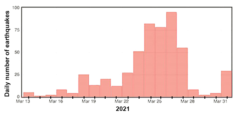 |
Figure 206. Histogram showing the daily number of volcano-tectonic earthquakes at Piton de la Fournaise during 13-31 March 2021. The number of daily earthquakes steadily increased from 13 through 26 March, after which it declined. Courtesy of OVPF-IPGP (Bulletin mensuel Mars 2021). |
During April a total of 1,575 volcano-tectonic earthquakes were detected below the summit craters, accompanied by 366 rockfall events in the Dolomieu crater, along the edges of the Enclos Fouqué caldera, the Piton de Crac, and the Rivière de l’Est. A notable seismic swarm was detected during 1447-1745 on 9 April consisting of 700 volcano-tectonic earthquakes beneath the Dolomieu crater and the S flank. At 1457 OVPF reported that the swarm was accompanied by rapid deformation, which indicated that magma was moving toward the surface. The seismicity indicated that a fissure had opened at 1900 on the S flank in the Enclos Fouqué caldera but could not be visually confirmed due to weather conditions. As a result, the Volcano Alert Level was raised to 2-2. An overflight at 0840 on 10 April showed an NNW-oriented fissure (700 m S of Château Fort), active lava fountains originating from two vents that rose no higher than 30 m, and a slow-moving `a`a lava flow that traveled SE and then curved E for 1.6 km to 1.8 km elevation (figure 207).
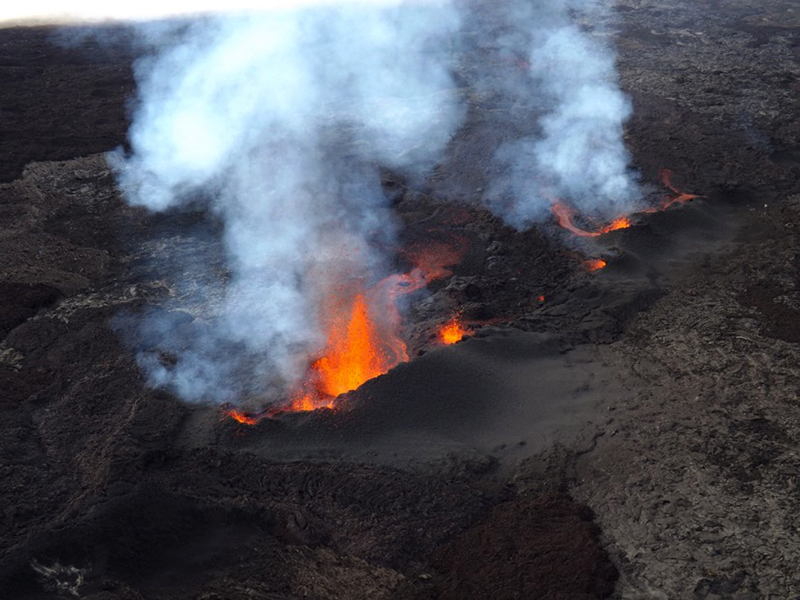 |
Figure 207. Photo of active lava fountains and white gas-and-steam emissions emerging from a fissure at Piton de la Fournaise taken at 0840 on 10 April 2021. Courtesy of OVPF-IPGP (Communiqué du 10/04/2021 - 10h00). |
By the morning of 11 April two cones were forming around the two active vents; the more northern of those was larger while the S one contained two vents (figure 208). Strong thermal anomalies on the S and SE flanks were visible on clear weather days during late April through mid-May 2021, based on Sentinel-2 infrared satellite imagery (figure 209), which were represented by the lava fountain activity that occurred during the eruptive period. Intermittent lava fountains rose 20-60 m high, and a single lava flow was observed at a rate of 8 m3/s, which increased to 10-30 m3/s, according to satellite data via the HOTVOLC platform (figures 210 and 211) at an elevation of 1.7 km. By 1900 on 11 April the lava flow was 3.2 km long. A gradual drop in the number of earthquakes was reported after the start of the eruption; on 11 April 89 shallow earthquakes were detected, which further decreased to 5 per day during 26-30 April.
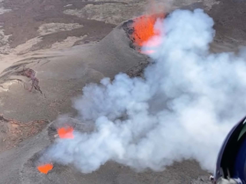 |
Figure 208. Overflight photo showing the three active vents at Piton de la Fournaise: a large northern vent (top right) and two smaller vents (bottom left) farther S, each of which generate lava fountains and white gas-and-steam emissions at 0930 on 16 April 2021. Courtesy of OVPF-IPGP (Communiqué du 16/04/2021 - 16h00). |
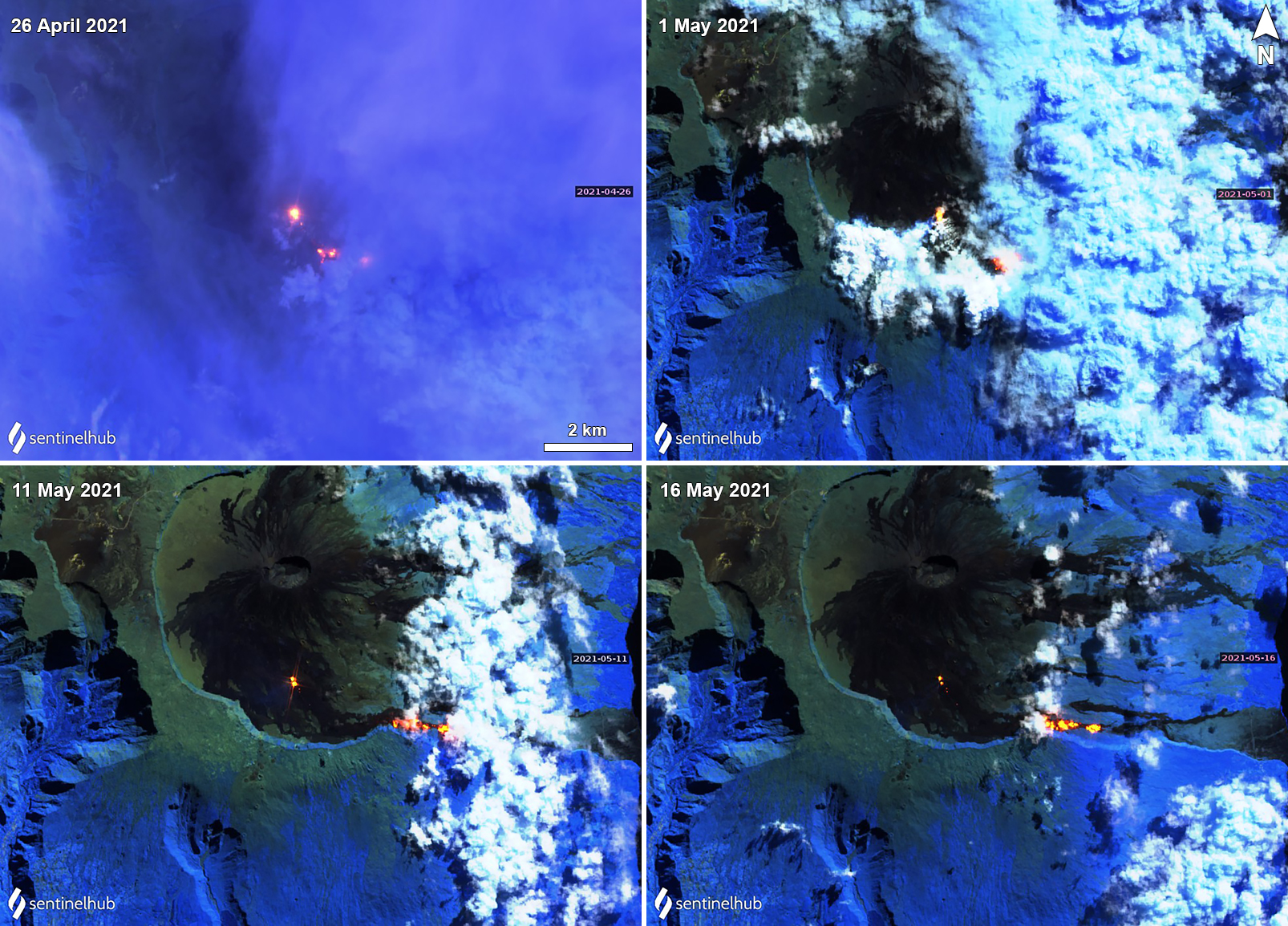 |
Figure 209. Sentinel-2 infrared satellite image of the thermal activity (bright yellow-orange) on the S and SE flanks of Piton de la Fournaise on 26 April (top left), 1 May (top right), 11 May (bottom left), and 16 May (bottom right) 2021, representing both the active lava fountains and flows. The larger thermal anomaly represents the N main vent, while the two weaker anomalies represent the smaller S vents. Sentinel-2 satellite images with “Atmospheric penetration” (bands 12, 11, 8A) rendering. Courtesy of Sentinel Hub Playground. |
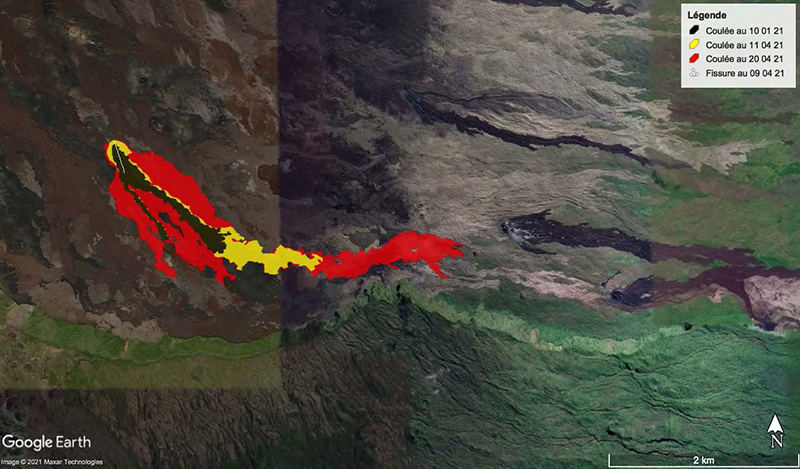 |
Figure 210. Satellite map of the evolution of the lava flows at Piton de la Fournaise during 10 April (black color within red and yellow zone), 11 April (yellow color), and 20 April (red color) 2021. Flows traveled SE before advancing dominantly E. The white line represents the fissure that opened on 9 April. The flow originated on the SE flank and migrated SE. Courtesy of OVPF-IPGP (Communiqué du 21/04/2021 - 16h00). |
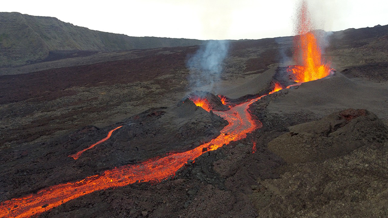 |
Figure 211. Photo of the activity at Piton de la Fournaise on 11 April 2021 showing lava fountains rising 30-60 m high from two vents, accompanied by an active lava flow. Courtesy of OVPF-IPGP (Communiqué du 11/04/2021 - 15h30). |
The sulfur dioxide emissions gradually increased from 400-859 tons/day during 9-12 April to an average of 4,054 tons/day on 13 April. The resulting plumes reached altitudes of 2.5-3.5 km altitude, according to NOVAC data. Distinct sulfur dioxide plumes were also detected by the Sentinel-5P/TROPOMI instrument each day during 10-13 April and drifted generally SW, which accompanied the new eruptive activity that began on 9 April (figure 212). Lava fountains continued at the two vents during 12-13 April, rising 20-60 m high while the flow continued to advance; by 13 April it was 3.6 km long and reached an elevation of 1.5 km. The lava flow rate increased to a maximum of 59 m3/s by 13 April, which later dropped to 12.5 m3/s on 14 April and 1.2-8.3 m3/s during 16-23 April. The approximate volume of lava erupted was 5 million cubic meters. In addition, the SO2 emissions dropped to 2,100 tons/day on 14 April and further to 1,100 tons/day on 15 April.
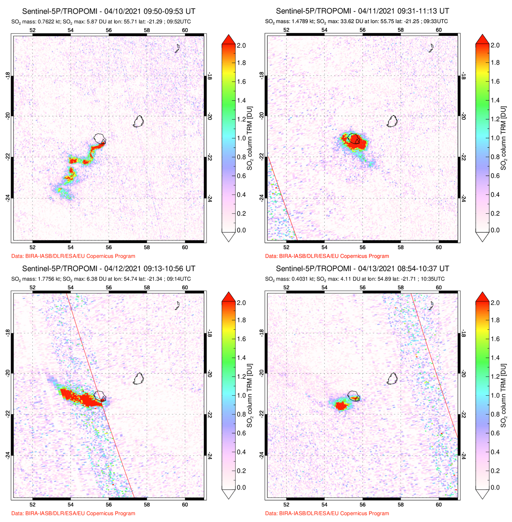 |
Figure 212. Distinct sulfur dioxide emissions rising above Piton de la Fournaise during 10-13 April 2021, accompanying the start of the new eruptive activity. The plume on 10 April (top left) drifted SW, on 11 April (top right) the plume remained above the island, on 12 April (bottom left) the plume drifted W, and on 13 April (bottom right) 2021 it drifted SW. Courtesy of NASA Global Sulfur Dioxide Monitoring Page. |
During an overflight on 16 April, scientists observed that the most distal part of the lava flow had stopped advancing while other parts were moving at rates of 1.2-8.3 m3/s. The larger northernmost cone was 28 m high; the smaller cone fed lava flows that traveled through tubes that occasionally broke the surface. The overall flow field was 3.5 km long and 750 m wide (figure 210). During the latter half of April and into early May, weather conditions frequently prevented visual observations of the activity, though the fountains and flows continued. The flow rates during 16-23 April were 1.2-8.3 m3/s, based on the gas emission rates. Lava flows continued to travel E through tubes, sometimes setting fire to local vegetation.
During May activity decreased slightly compared to the previous month; the intensity of the volcano-tectonic earthquakes declined and on clear weather days (figure 213), the lava fountains were still visible in the smaller vents but were weaker, occasionally ejecting material just above the crater rim. A total of 261 rockfalls were detected in the Dolomieu crater and along the Enclos Fouqué caldera, the Piton de Crac, and the Rivière de l’Est. Photo analysis of the larger N cone showed that its base width was 226 m and had a height of 35 m. The lava flow had resumed its advancement E by 2 May at a rate of 7 m3/s after a pause in activity during 29 April to 1 May, extending to 180 m long to an elevation of 1.5 km (figure 214). Some local vegetation caught fire due to the flow. During 3-4 May a small active lava lake was reported in the N vent, lava fountains ejected material 5-6 m high, while stronger and denser gas-and-steam plumes rose above the two smaller S vents. On the morning of 12 May OVPF-IPGP reported that the lava lake in the N main cone had disappeared, and by 13 May the lava flows that were traveling through tubes had migrated E to an elevation of 920 m. OVPF-IPGP reported that on 24 May around 0200 the eruption ended, based on the cessation of volcanic tremors; the number of volcano-tectonic earthquakes had declined to two shallow volcano-tectonic earthquakes per day and the total volume of lava effusions was about 13 million cubic meters. Inclement weather again prevented visual confirmation, however.
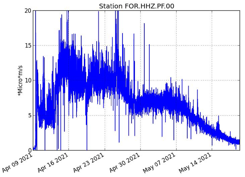 |
Figure 213. Graph showing the intensity of the volcano-tectonic earthquakes detected at Piton de la Fournaise (in RSAM units) from 9 April through 19 May 2021. There is a significant spike in RSAM units at the start of the eruption, which continued to increase overall through at least 24 April; a gradual decrease is observed from late April through May. Courtesy of OVPF-IPGP (Communiqué du 19/05/2021 14h00). |
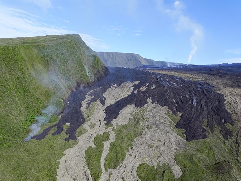 |
Figure 214. Photo of the front of the cooling lava flow at Piton de la Fournaise at 0915 on 3 May 2021 taken from the SAG helicopter overflight. The darker lava is the active flow that is slowly advancing downslope while the lighter lava is older and cooled. To the left is a white gas-and-steam plume indicating burning vegetation; a white gas-and-steam plume is also visible in the background (to the right). Courtesy of OVPF-IPGP (Communiqué du 03/05/2021 – 15h00). |
Geological Summary. Piton de la Fournaise is a massive basaltic shield volcano on the French island of Réunion in the western Indian Ocean. Much of its more than 530,000-year history overlapped with eruptions of the deeply dissected Piton des Neiges shield volcano to the NW. Three scarps formed at about 250,000, 65,000, and less than 5,000 years ago by progressive eastward slumping, leaving caldera-sized embayments open to the E and SE. Numerous pyroclastic cones are present on the floor of the scarps and their outer flanks. Most recorded eruptions have originated from the summit and flanks of Dolomieu, a 400-m-high lava shield that has grown within the youngest scarp, which is about 9 km wide and about 13 km from the western wall to the ocean on the E side. More than 150 eruptions, most of which have produced fluid basaltic lava flows, have occurred since the 17th century. Only six eruptions, in 1708, 1774, 1776, 1800, 1977, and 1986, have originated from fissures outside the scarps.
Information Contacts: Observatoire Volcanologique du Piton de la Fournaise, Institut de Physique du Globe de Paris, 14 route nationale 3, 27 ème km, 97418 La Plaine des Cafres, La Réunion, France (URL: http://www.ipgp.fr/fr); NASA Global Sulfur Dioxide Monitoring Page, Atmospheric Chemistry and Dynamics Laboratory, NASA Goddard Space Flight Center (NASA/GSFC), 8800 Greenbelt Road, Goddard, Maryland, USA (URL: https://so2.gsfc.nasa.gov/); Sentinel Hub Playground (URL: https://www.sentinel-hub.com/explore/sentinel-playground).