Report on San Cristobal (Nicaragua) — July 2021

Bulletin of the Global Volcanism Network, vol. 46, no. 7 (July 2021)
Managing Editor: Edward Venzke.
Edited by Kadie L. Bennis.
San Cristobal (Nicaragua) New eruption characterized by thermal anomalies, few explosions, and ash
Please cite this report as:
Global Volcanism Program, 2021. Report on San Cristobal (Nicaragua) (Bennis, K.L., and Venzke, E., eds.). Bulletin of the Global Volcanism Network, 46:7. Smithsonian Institution. https://doi.org/10.5479/si.GVP.BGVN202107-344020
San Cristobal
Nicaragua
12.702°N, 87.004°W; summit elev. 1745 m
All times are local (unless otherwise noted)
San Cristóbal, located in Nicaragua, is a volcanic complex consisting of five edifices. Sporadic volcanism dates back to 1528, with frequent eruptions over the past 50 years. The previous eruption in March 2019 was characterized by weak ash explosions with intermittent gas-and-ash emissions (BGVN 44:04). This report updates activity from April 2019 through June 2021 and describes a new eruption beginning on 27 December 2020, when thermal anomaly was first identified. A later series of five explosions resulted in an ash plume and ashfall. Information comes from the Instituto Nicaragüense de Estudios Territoriales (INETER), the Sistema Nacional para la Prevencion, Mitigacion y Atencion de Desastres (SINAPRED), the Washington Volcanic Ash Advisory Center (VAAC), and various satellite data.
Activity during April 2019 through November 2020 was relatively calm and primarily consisted of gas-and-steam emissions and seismicity. Monitoring data reported by INETER consistently included the average sulfur dioxide levels (tons/day) and total number of earthquakes per month, a small number of which were volcano-tectonic events (table 7). Some landslides were noted in the inner part of the crater in the April 2019 monthly report.
Table 7. Monthly sulfur dioxide measurements and seismicity reported at San Cristóbal during April 2019-March 2021.
| Month | Average SO2 | Total earthquakes | Volcano-tectonic (VT) earthquakes |
| Apr 2019 | 251 t/d | 5,663 | -- |
| May 2019 | -- | 7,663 | -- |
| Jun 2019 | 440 t/d | 40,525 | -- |
| Jul 2019 | 340 t/d | 47,255 | -- |
| Aug 2019 | 323 t/d | 58,060 | -- |
| Sep 2019 | 323 t/d | 70,446 | -- |
| Oct 2019 | 515 t/d | 74,327 | -- |
| Nov 2019 | 404 t/d | 81,348 | -- |
| Dec 2019 | -- | 87,874 | -- |
| Jan 2020 | -- | 38,291 | -- |
| Feb 2020 | 263 t/d | 74,414 | -- |
| Mar 2020 | 141 t/d | 81,097 | -- |
| Apr 2020 | 172 t/d | 88,670 | -- |
| May 2020 | 151 t/d | 99,991 | -- |
| Jun 2020 | 187 t/d | 107,030 | 31 |
| Jul 2020 | 179 t/d | 121,076 | 31 |
| Aug 2020 | 259 t/d | 138,810 | 39 |
| Sep 2020 | 729 t/d | 149,333 | 78 |
| Oct 2020 | 215 t/d | 189,338 | 113 |
| Nov 2020 | 155 t/d | 214,078 | 126 |
| Dec 2020 | -- | 230,463 | 126 |
| Jan 2021 | 336 t/d | 15,221 | 2 |
| Feb 2021 | 317 t/d | 7,923 | 2 |
| Mar 2021 | 381 t/d | -- | -- |
| Apr 2021 | 374 t/d | 6,645 | 33 |
| May 2021 | 546 t/d | 6,273 | 4 |
| Jun 2021 | 934 t/d | 4,074 | 16 |
Starting in December 2020 and continuing through June 2021 intermittent thermal activity was recorded in the Sentinel-2 MODIS Thermal Volcanic Activity (figure 39). This data reflects the start of the new eruption in December, some of which was also observed in Sentinel-2 thermal satellite imagery in the summit crater on clear weather days. The start of the eruption was captured in satellite imagery on 27 December 2020 with two weak thermal anomalies in the crater (figure 40); additional intermittent anomalies were detected from different locations in the crater through June 2021.
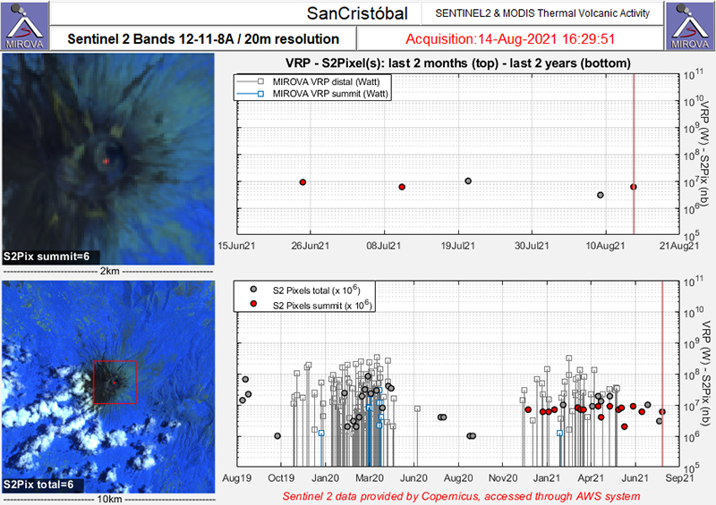 |
Figure 39. Sentinel-2 MODIS Thermal Volcanic Activity data (bands 12, 11, 8A) showing renewed thermal activity (red dots) at San Cristóbal in December 2020 that continues intermittently through June 2021. Initial activity marks the start of the new eruption that began in December. Courtesy of MIROVA. |
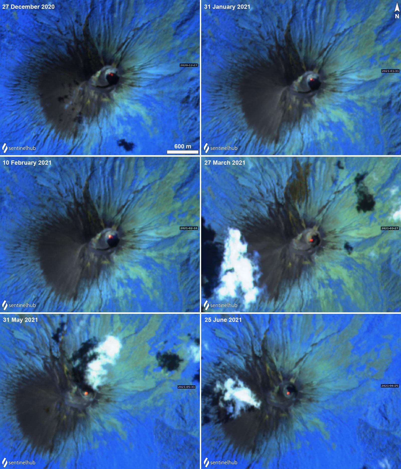 |
Figure 40. Sentinel-2 thermal satellite imagery showing the start of a new eruptive episode at San Cristóbal with two faint thermal anomalies in the summit crater on 27 December 2020 (top left). A slightly stronger thermal anomaly was observed on clear weather days in the summit crater on 31 January (top right), 10 February (bottom left), 27 March (bottom right), 31 May (bottom left), and 25 June (bottom right) 2021. Images use “Atmospheric penetration” (bands 12, 11, 8A) rendering. Courtesy of Sentinel Hub Playground. |
INETER reported that at 1505 on 14 February 2021 a gas explosion produced a small ash emission. A Washington VAAC report noted that the ash cloud rose to 2.3 km altitude and drifted SW. Most of the ash was deposited on the slopes, some of which extended to Apastepe, Juan José Briceño, Las Nubes, Los Ébanos, Las Brisas, Versalles, Los Pellizcos, Valle de Los Morenos, and Los Chavarría. On 9 March SINAPRED reported that a series of five explosions were recorded during 1306-1332, the strongest of which occurred at 1325 and produced an ash plume that rose 800 m above the crater rim (figure 41). The Washington VAAC reported that the ash plume rose to 2.4 km altitude and drifted SW, though it was difficult to see in satellite imagery due to cloud cover. As a result, up to 2 mm of ashfall was reported in El Viejo (19 km WSW), Chinandega (16 km SW), and Chichigalapa (16 km S), as well as in other communities downwind including Las Grecias, La Mora, and La Bolsa. On 19 March a notable ash plume rose to 12.2 km altitude and drifted more than 80 km ENE, according to satellite data, ash dispersion models, and weather models.
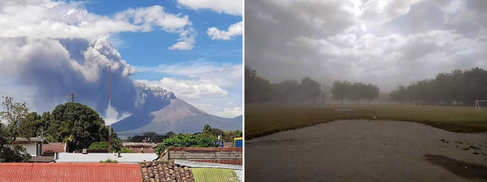 |
Figure 41. Photos of the explosion at San Cristóbal at 1326 on 9 March 2021 that generated an ash plume and rose up to 800 m above the crater (left) and ashfall in surrounding communities (right). Courtesy of SINAPRED. |
Geological Summary. The San Cristóbal volcanic complex, consisting of five principal volcanic edifices, forms the NW end of the Marrabios Range. The symmetrical 1745-m-high youngest cone, named San Cristóbal (also known as El Viejo), is Nicaragua's highest volcano and is capped by a 500 x 600 m wide crater. El Chonco, with several flank lava domes, is located 4 km W of San Cristóbal; it and the eroded Moyotepe volcano, 4 km NE of San Cristóbal, are of Pleistocene age. Volcán Casita, containing an elongated summit crater, lies immediately east of San Cristóbal and was the site of a catastrophic landslide and lahar in 1998. The Plio-Pleistocene La Pelona caldera is located at the eastern end of the complex. Historical eruptions from San Cristóbal, consisting of small-to-moderate explosive activity, have been reported since the 16th century. Some other 16th-century eruptions attributed to Casita volcano are uncertain and may pertain to other Marrabios Range volcanoes.
Information Contacts: Instituto Nicaragüense de Estudios Territoriales (INETER), Apartado Postal 2110, Managua, Nicaragua (URL: http://www.ineter.gob.ni/); Sistema Nacional para la Prevencion, Mitigacion y Atencion de Desastres (SINAPRED), Edificio SINAPRED, Rotonda Comandante Hugo Chávez 50 metros al Norte, frente a la Avenida Bolívar, Managua, Nicaragua (URL: http://www.sinapred.gob.ni/); Washington Volcanic Ash Advisory Center (VAAC), Satellite Analysis Branch (SAB), NOAA/NESDIS OSPO, NOAA Science Center Room 401, 5200 Auth Rd, Camp Springs, MD 20746, USA (URL: www.ospo.noaa.gov/Products/atmosphere/vaac, archive at: http://www.ssd.noaa.gov/VAAC/archive.html); MIROVA (Middle InfraRed Observation of Volcanic Activity), a collaborative project between the Universities of Turin and Florence (Italy) supported by the Centre for Volcanic Risk of the Italian Civil Protection Department (URL: http://www.mirovaweb.it/); Sentinel Hub Playground (URL: https://www.sentinel-hub.com/explore/sentinel-playground).