Report on Sangay (Ecuador) — July 2021

Bulletin of the Global Volcanism Network, vol. 46, no. 7 (July 2021)
Managing Editor: Edward Venzke.
Edited by A. Elizabeth Crafford.
Sangay (Ecuador) Multiple explosions send ash over 3 km above the summit during March-May 2021
Please cite this report as:
Global Volcanism Program, 2021. Report on Sangay (Ecuador) (Crafford, A.E., and Venzke, E., eds.). Bulletin of the Global Volcanism Network, 46:7. Smithsonian Institution. https://doi.org/10.5479/si.GVP.BGVN202107-352090
Sangay
Ecuador
2.005°S, 78.341°W; summit elev. 5286 m
All times are local (unless otherwise noted)
Frequent activity at Ecuador's Sangay has included pyroclastic flows, lava flows, ash plumes, and lahars reported since 1628. Its remoteness on the east side of the Andean crest makes ground observations difficult; web cameras and satellites provide important information on activity. The current eruption began in March 2019 and has continued into 2021. Ongoing activity from January-June 2021 covered in this report includes explosions with ash plumes, large SO2 plumes, incandescent ejecta, lava flows, and numerous lahars. Information is provided by Ecuador's Instituto Geofísico, Escuela Politécnica Nacional (IG-EPN), and multiple sources of remote data including the Washington Volcanic Ash Advisory Center (VAAC), the Italian MIROVA Volcano HotSpot Detection System, and Sentinel-2 satellite imagery.
Throughout January-June 2021, multiple daily reports from the Washington VAAC indicated ash plumes rising generally 500-2,100 m above the summit. During March-May plumes rose over 3 km above the summit multiple times and they usually drifted SW or W with ashfall reported in communities 25-90 km away after most of the larger explosive events. Incandescent ejecta and blocks descended a large, deep ravine on the SE flank a few times each month. The MIROVA log radiative power graph showed continued moderate and high levels of thermal anomalies into March; they decreased somewhat in frequency and intensity after that through June (figure 97). Small and moderate-size SO2 plumes were detected with satellite instruments daily during January and February. During March and April very large SO2 plumes accompanied the large explosions and ash plumes. Some of the large explosions during May were also accompanied by significant SO2 emissions.
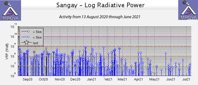 |
Figure 97. Moderate and high levels of intensity of thermal anomalies were recorded by the MIROVA project for Sangay from 13 August 2020 through mid-March 2021. Thermal activity decreased somewhat in frequency and intensity after March through June 2021. Courtesy of MIROVA. |
Activity during January-March 2021. Three to five daily volcanic ash advisories were issued by the Washington VAAC during January 2021. Ash emissions were observed in satellite images rising 500-2,400 m above the summit, drifting W or SW on most days. On 11 January the Washington VAAC reported ash plumes visible in satellite imagery drifting W at 7.6 km altitude (2,300 m above the summit) 100-150 km from the summit. Extensive cloud cover made webcam observations infrequent, but plumes of gas and ash were observed rising 2,000 m above the summit and drifting NW on 12 January. The Volcan Sangay webcam also captured ash emissions on 16 and 21 January, and Sentinel infrared satellite images showed hot material on the SE flank and ash emissions on those same days as well (figure 98). Ashfall was reported in Chimborazo and Guayas on 24 January. Seismic signals indicating mud and debris flows from the near-daily rain were recorded during 11-14 and 22-26 January; no damage was reported.
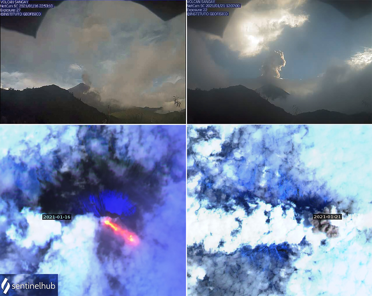 |
Figure 98. Webcam images on 16 and 21 January 2021 recorded ash emissions from the summit of Sangay (top row). Sentinel-2 satellite images on those same days also recorded evidence of activity. On 16 January (bottom left) strong thermal signals from the ravine on the SE flank indicated some type of hot material moving. A dense ash plume drifted NW from the summit on 21 January above the meteoric cloud cover (bottom right). Satellite images use Atmospheric penetration rendering (bands 12, 11, 8a). Top images courtesy of IG daily reports, bottom images courtesy of Sentinel Hub Playground. |
Multiple daily ash emissions reported by the Washington VAAC during February 2021 indicated that plumes generally rose 600-1,800 m above the summit with drift directions primarily SW or W. Cloudy weather conditions prohibited webcam observations on many days, however gas and ash emissions were observed drifting SW at 1,500 m above the summit on 4 February, SW at 800-1,000 m above the summit during 9-11 February, and drifting N and W at 500-1,500 m high during 15-18 February. Incandescent material descended the SE flank overnight during 2-3 and 10 February (figure 99), and ashfall was reported N and W of Macas on 10 February. Seismic vibrations indicating lahars were recorded on 2, 3, 7, 11, 12, 16, and 25 February; no damage was reported.
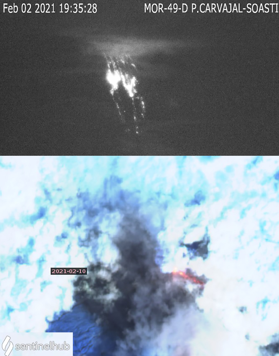 |
Figure 99. Incandescent hot material descended the SE flank of Sangay on 2 and 10 February 2021. Top image is from IG webcam, bottom is Sentinel-2 satellite thermal imagery with Atmospheric penetration rendering (bands 12, 11, 8a). Left image courtesy of IG-EPN; right image courtesy of Sentinel Hub Playground. |
Daily explosions with ash plumes continued during March 2021; emissions generally rose 600-2,000 m above the summit. Two episodes of larger explosive events that resulted in substantial ashfall were recorded during 6-7 and 11 March. The Washington VAAC initially reported an ash plume drifting W 50 km from the summit at 9.1 km altitude (3.8 km above the summit) early on 6 March. It fanned out from the NW to the SW up to 170 km at that altitude and additional ash was drifting E from the summit below 5.8 km altitude. This was followed later in the day by a second explosion with a large ash plume that drifted in three directions: E at 6.1 km altitude, SW at 7.3 km altitude, and W at 10.7 km altitude. Several hours later the leading edge of the ash plume was located 300 km W of the summit at 12.2 km altitude while another part of the plume extended 130 km WSW at 8.2 km altitude (figure 100). This resulted in significant ashfall in numerous communities. Ashfall was reported on 6 March in Cumandá, and on 6 and 7 March in Bolívar, Milagro, San Jacinto de Yaguachi, El Triunfo, Daule, Samboróndon, Coronel Marceliño Maridueña, Durán, Naranjito, Alfredo Baquerizo Moreno, Playas, Guamote, Alausí, Pallatanga, Chunchí and Colta. Traces of ashfall were still reported on 8 March in Guamote and Alausí.
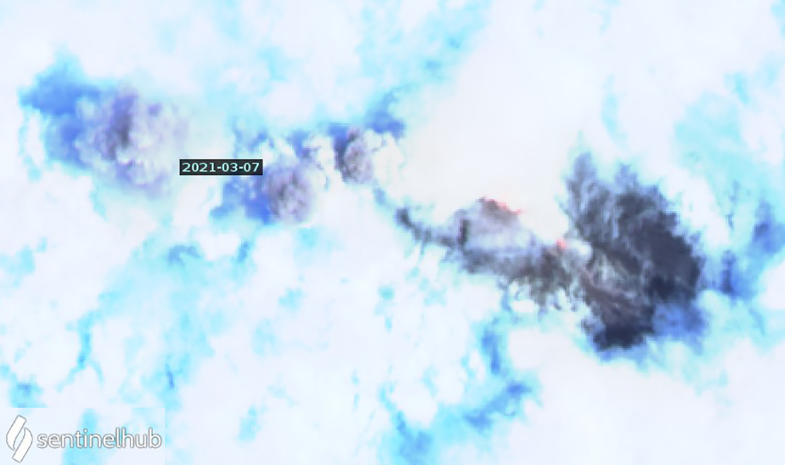 |
Figure 100. A dense ash plume above meteoric clouds extends several kilometers NW from Sangay after a large explosion on 7 March 2021; hot material is also visible on the SE flank. The summit itself is obscured by clouds. Sentinel-2 image uses Atmospheric penetration rendering (bands 12, 11, 8a). Courtesy of Sentinel Hub Playground. |
A large explosion on 11 March initially rose to 12.5 km altitude and spread out 45 km in all directions with additional ash extending 100 km W. A little over an hour later it was still expanding in all directions and moving mostly W at 13.7 km altitude about 100 km from the summit. It dissipated rapidly and was no longer detectible in satellite imagery 8 hours later. Significant ashfall from the explosion was recorded that day in the Canton of Guamote, moderate ashfall was reported in the Cantons of Chambo, Riobamba, Penipe, and Guano, and traces of ash were reported in Colta, Alausí and Macas (figure 101). Very large SO2 plumes detected by satellite instruments from the explosions on 6-7 and 11-12 March drifted hundreds of kilometers before dissipating (figure 102). Steam and gas emissions with low ash content were observed in a webcam on 14 March rising to 600 m above the summit and drifting E and NE (figure 103). Vibrations from mudflows and lahars were measured on 16 days during March. On 12 March the Macas authorities reported an overflow of the Upano River dam by mud and debris flows. On 24 March the rains generated signals associated with mud and debris flows that lasted for three hours.
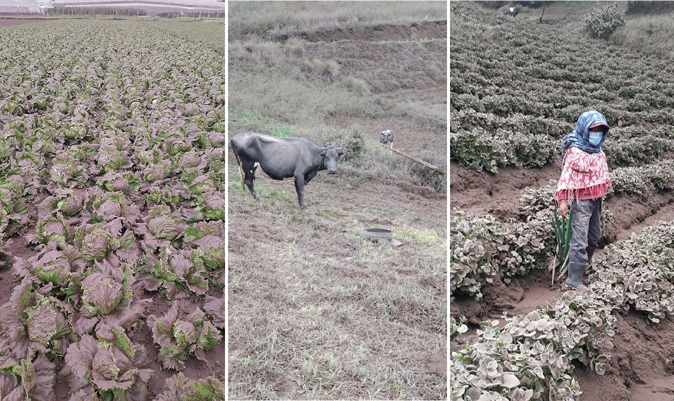 |
Figure 101. Crops, livestock, and people were affected by significant ashfall in multiple provinces after large explosions from Sangay on 11 March 2021. Courtesy of Fundación Maquita. |
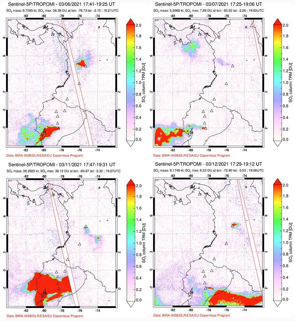 |
Figure 102. Very large SO2 plumes were detected by the TROPOMI instrument on the Sentinel-5P satellite from Sangay during 6-7 (top) and 11-12 (bottom) March 2021. Colombia’s Nevado del Ruiz also had small and moderate SO2 emissions throughout the month of March. Explosions produced ash plumes that rose to 12.2 km altitude on 6-7 March and 13.7 km altitude on 11 March, dispersing SO2 over a large area of the upper atmosphere. Courtesy of NASA Global Sulfur Dioxide Monitoring Page. |
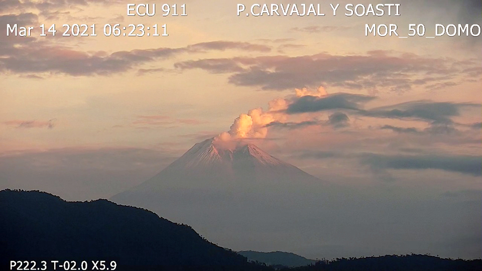 |
Figure 103. Steam and gas with low ash content drifted N and NE from Sangay in the early morning on 14 March 2021. Courtesy of IG-EPN. |
Activity during April-June 2021. A notable increase in the flow of the Upano River was reported on 4 April 2021 after heavy rains, and vibrations from lahars were recorded 13 times throughout the month. Multiple daily VAAC reports continued throughout April, similar to previous months. The daily ash emissions generally rose 600-2,100 m above the summit and drifted W, SW, and NW. An incandescent flow was observed descending the upper part of the SE flank overnight on 4-5 April (figure 104). Incandescence at the summit was also visible overnight during 19-20 April.
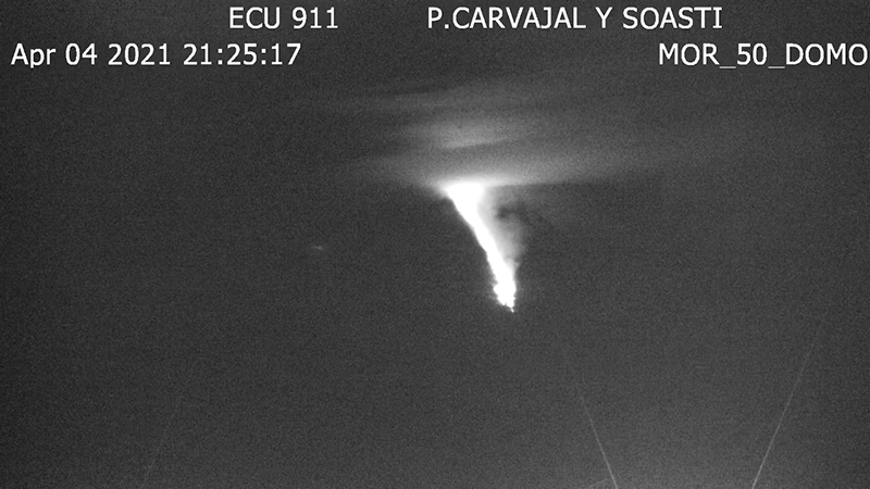 |
Figure 104. An incandescent flow was observed descending the upper part of the SE flank of Sangay late on 4 April 2021. Courtesy of IG Daily Reports. |
The Washington VAAC reported a large eruptive event on 13 April 2021 that started shortly after midnight (UTC) and sent an ash cloud to 8.2 km altitude that drifted 50 km WNW but also fanned out in all directions. Less than three hours later the cloud was reported at 12.2 km altitude continuing to drift about 100 km WNW. A large plume of SO2 was also detected by satellite instruments from this event (figure 105). Ashfall was reported in the Provinces of Chimborazo, Bolivar, Los Rios, and Guayas. Significant amounts of ash fell in the Cantons of Guamote and Chillanes, moderate amounts fell in Riobamba, Guaranda, San Miguel and Chimbo, and trace amounts were reported in Colta, Chunchi, Babahoyo, Montalvo, Vinces, Guayaquil, Durán, Samborondón, Alfredo Baquerizo Moreno, Salitre, and San Jacinto de Yaguach. Ash plumes on 17 and 18 April drifted W and caused ashfall in Guamote located in the Chimborazo Province (figure 106).
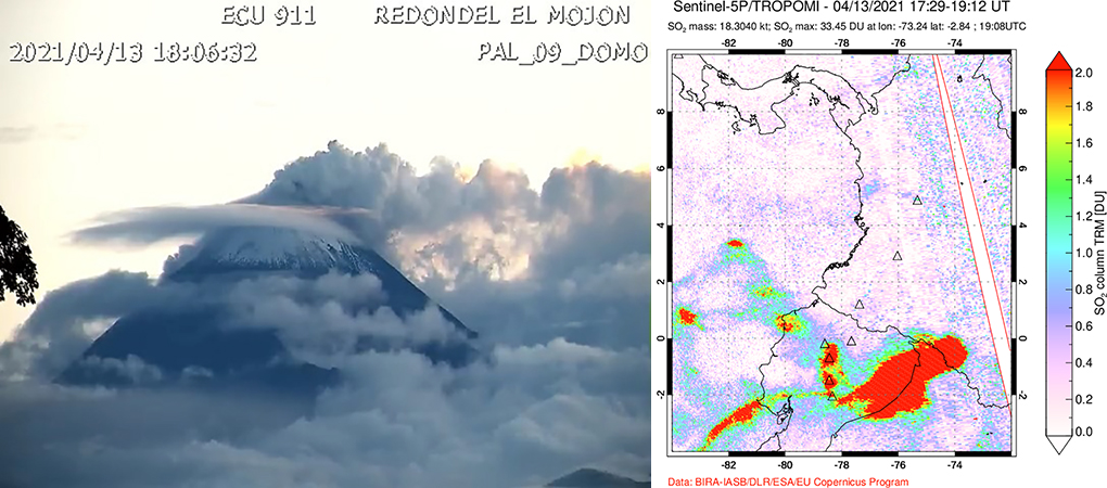 |
Figure 105. A large explosion at Sangay on 13 April 2021 sent ash to over 12 km altitude. By later in the day, steam and gas emissions were drifting away from the summit at low altitude (left). The event produced a large SO2 plume that was detected by the TROPOMI instrument on the Sentinel-5P satellite (right). Courtesy of IG-EPN Daily Information Report (left) and NASA Global Sulfur Dioxide Monitoring Page (right). |
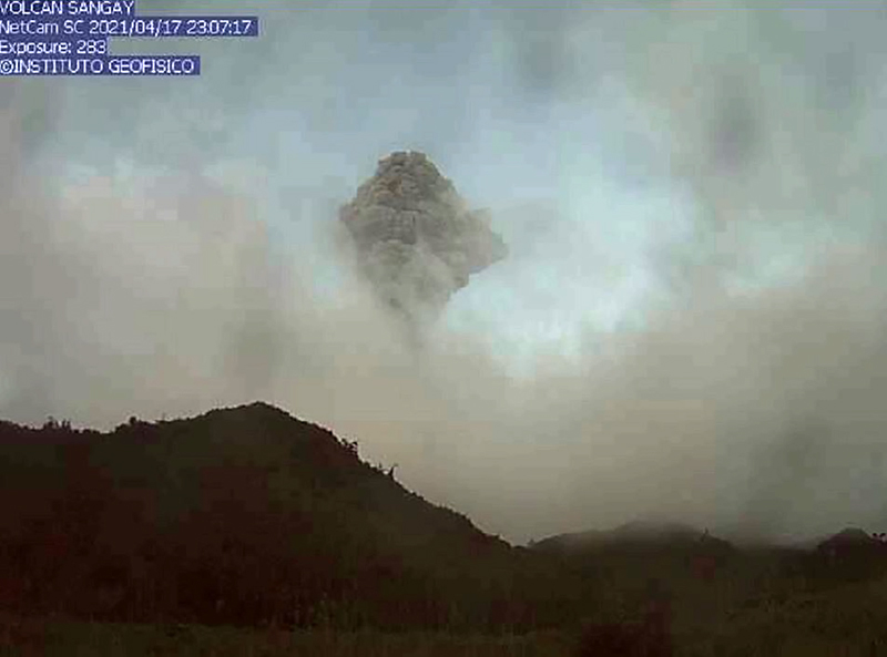 |
Figure 106. A dense ash plume rose from Sangay on 17 April 2021 and was responsible for ashfall in Guamote located in the Chimborazo Province. Courtesy of IG Daily Information Report. |
The Washington VAAC reported ash emissions that rose as high as 7.6 km altitude on 20 April 2021; they were drifting NW 15 km from the summit in addition to continuing emissions from earlier events that were drifting WSW at 6.1 km altitude 75 km from the volcano (figure 107). IG reported another strong eruptive pulse from Sangay on 28 April that produced an ash plume that rose to 5-7 km above the summit and drifted NNE and SSW. The Washington VAAC reported three different directions of drift from the explosion at different altitudes; the lower-level ash was moving NNW at 5.8 km altitude, the mid-level ash was moving W at 7.0 km altitude, and the higher-level ash was moving SW at 9.7 km altitude. The plume dissipated after a few hours and no ashfall was reported.
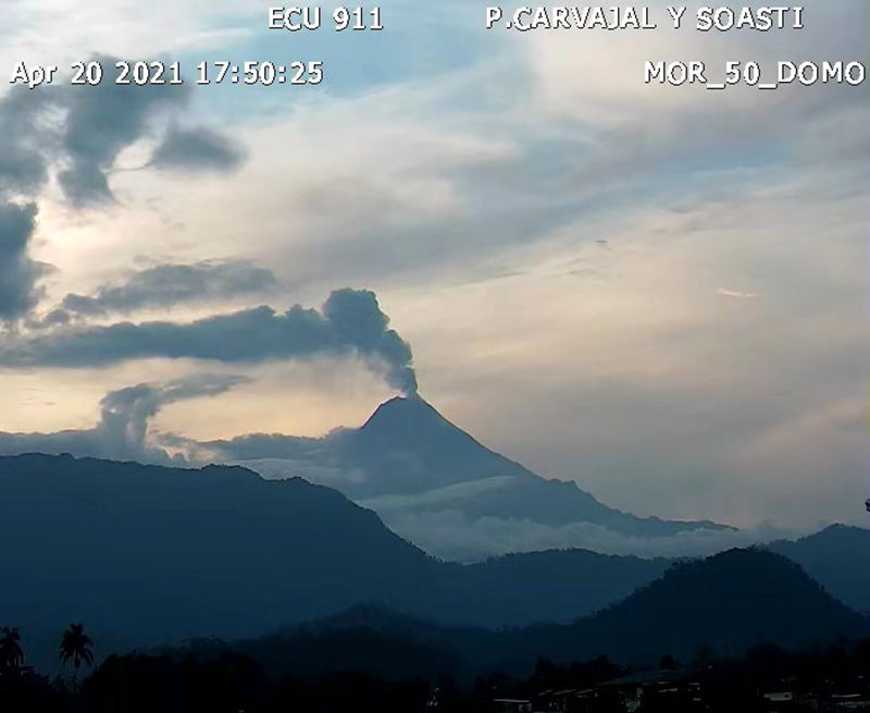 |
Figure 107. Ash emissions drifted up to 75 km W from Sangay on 20 April 2021. Courtesy of IG-EPN Daily Information Report. |
Abundant rain during May 2021 resulted in eighteen days with reports of lahars; an increase in the flow of Rio Upano was reported on 16 May. Explosive activity increased in intensity during May 2021. There were six days when emissions were reported rising over 3 km above the summit in addition to daily plumes that rose 200-2,000 m high and usually drifted W, NW, or SW. Overnight on 7-8 May the Washington VAAC reported an ash plume that extended 100 km WSW from the summit at 7.6 km altitude and NW at 10.6 km altitude. The webcam captured incandescent lava descending the SE flank that evening (figure 108). Large SO2 plumes were detected by satellite instruments on both days. Significant ashfall from the event was recorded in multiple provinces including Chimborazo in the Cebadas and Palmira parishes of Guamote canton and in the Pungalá and Flores parishes of the Riobamba canton. Moderate ashfall was reported in Punín and Colta parishes in the Riobamba canton. Trace ashfall was reported in the parishes of Tixán and the high part of Licto in the Alusi canton. On the morning of 8 May trace amounts of ash were reported in the province of Guayas, in the cantons of Salitre, Alfredo Baquerizo Moreno (Jujan), Samborondón, Dúran, and Daule.
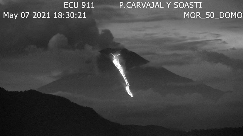 |
Figure 108. Incandescent ejecta and lava flows were observed in the webcams at Sangay overnight on 7-8, 20-21, and 30-31 May 2021. Courtesy of IG-EPN Daily Information Report. |
An eruption on 16 May 2021 produced an ash plume that rose to 11.3 km altitude and drifted 140 km N. A lower-level plume was also drifting WSW 80 km from the summit at 6.4 km altitude. Traces of ashfall were reported in Ishupamba-Chimborazo. The ash plume was discernible in Sentinel-2 satellite imagery above a dense meteoric cloud layer (figure 109). An explosion on 20 May produced an ash plume reported by the Washington VAAC extending over 100 km SW from the summit at 9.5 km altitude and also fanning out 75-100 km SE and S of the summit at 7.6 km altitude. Ashfall from this event was reported in the regions of Guamote and Ichupamba in the Chimborazo province. Incandescent ejecta was noted overnight on 21-22 May (figure 110) and a substantial ash plume seen in satellite imagery produced ashfall in Ichupamba, San Nicolas, Guamote, Alausi, Cumandá, Tixan, Sibambe, and Achupallas in the province of Chimborazo and in General Elizalde in Guayas Province. The Washington VAAC reported the ash plume moving E at 9.1 km altitude and W at 7.6 km altitude.
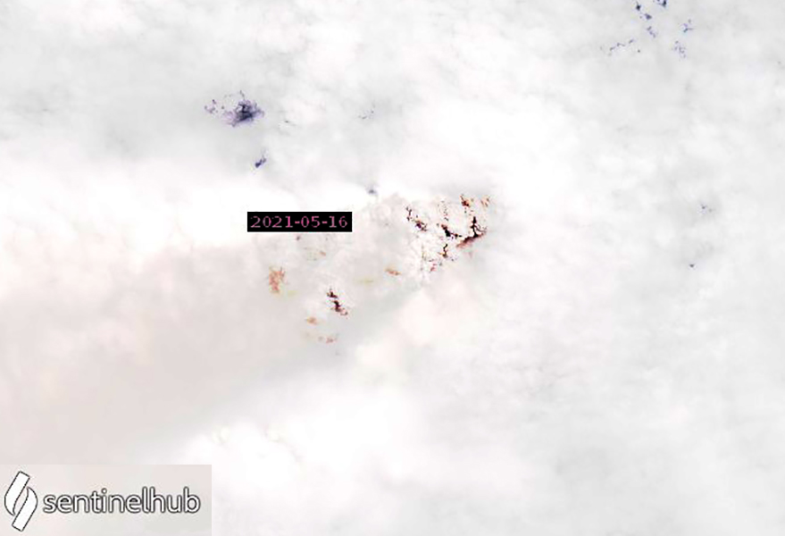 |
Figure 109. An explosion at Sangay on 16 May 2021 produced an ash plume that was visible drifting WSW from the summit above a dense cloud layer. Image uses Natural color rendering (bands 4, 3, 2), the contrast has been enhanced. Courtesy of Sentinel Hub Playground. |
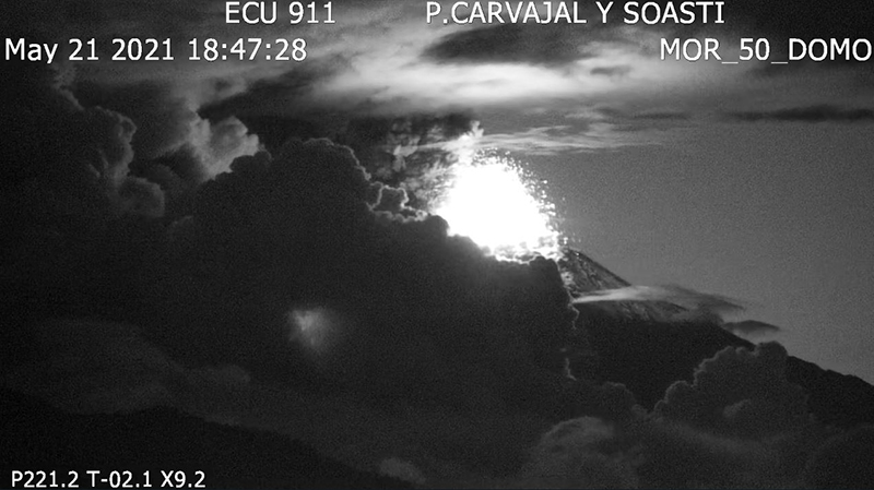 |
Figure 110. Eruptive activity at Sangay overnight on 21-22 May 2021 produced incandescent ejecta and a dense ash plume Courtesy of IG Daily Information Report. |
High-level ash emissions continued during 25-27 May 2021, although no ashfall was reported. The Washington VAAC reported a large eruption on 25 May that sent ash plumes in three different directions; ash was moving W at 5.2 km altitude, E at 6.7 km altitude, and S at 9.8 km altitude. During the next two days additional emissions produced plumes that drifted SE and SW at 7.6-8.2 km altitude. Incandescent explosions produced incandescent material that descended the flanks overnight on 30-31 May. Reports were received from communities near the volcano of loud noises and vibrations rattling windows. The Washington VAAC reported ash emissions that rose to 7.9 km altitude and drifted 100 km SW. The SNGRE (Servicio Nacional de Gestión de Riesgos y Emergencias) reported ash fall in the Alausí, Guamote and Chunchi cantons of the Chimborazo province. Emissions continued the next day, 1 June (figure 111), and ashfall was again reported in Alausí and Chunchi.
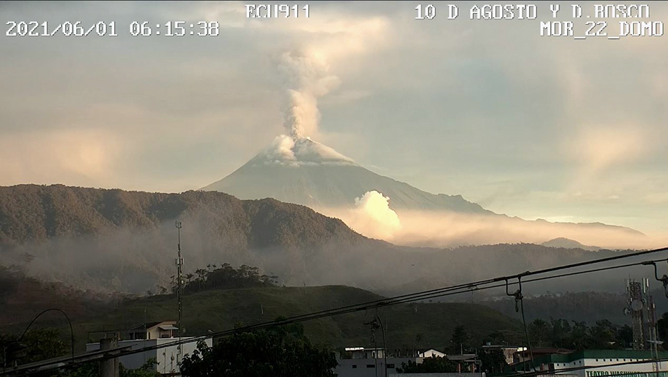 |
Figure 111. Ash emissions continued at Sangay on 1 June 2021 after incandescent explosions and ashfall occurred the day before. Courtesy of IG Daily Information Report. |
No ashfall was reported during June 2021 after the 1st, though daily ash emissions continued, rising 400-1,500 m above the summit and usually drifting W, SW, or NW. Continuous ash clouds drifting 40 km NW were observed on 10 June by the Washington VAAC; they were also visible that day in Sentinel-2 satellite imagery along with a thermal anomaly from the summit crater (figure 112). Incandescence appeared at the summit crater and blocks rolled down the SE flank overnight on 27-28 June. Lahar signals were reported on 19 days during the month.
 |
Figure 112. Ash emissions drifting WNW and a thermal anomaly at the summit of Sangay appeared in Sentinel-2 satellite imagery on 10 June 2021. Image uses Atmospheric penetration rendering of bands 12, 11, and 8a. Courtesy of Sentinel Hub Playground. |
Geological Summary. The isolated Sangay volcano, located east of the Andean crest, is the southernmost of Ecuador's volcanoes and its most active. The steep-sided, glacier-covered, dominantly andesitic volcano grew within the open calderas of two previous edifices which were destroyed by collapse to the east, producing large debris avalanches that reached the Amazonian lowlands. The modern edifice dates back to at least 14,000 years ago. It towers above the tropical jungle on the east side; on the other sides flat plains of ash have been eroded by heavy rains into steep-walled canyons up to 600 m deep. The earliest report of an eruption was in 1628. Almost continuous eruptions were reported from 1728 until 1916, and again from 1934 to the present. The almost constant activity has caused frequent changes to the morphology of the summit crater complex.
Information Contacts: Instituto Geofísico, Escuela Politécnica Nacional (IG-EPN), Casilla 17-01-2759, Quito, Ecuador (URL: http://www.igepn.edu.ec/); MIROVA (Middle InfraRed Observation of Volcanic Activity), a collaborative project between the Universities of Turin and Florence (Italy) supported by the Centre for Volcanic Risk of the Italian Civil Protection Department (URL: http://www.mirovaweb.it/); Sentinel Hub Playground (URL: https://www.sentinel-hub.com/explore/sentinel-playground); NASA Global Sulfur Dioxide Monitoring Page, Atmospheric Chemistry and Dynamics Laboratory, NASA Goddard Space Flight Center (NASA/GSFC), 8800 Greenbelt Road, Goddard, Maryland, USA (URL: https://so2.gsfc.nasa.gov/); Fundación Maquita (URL: https://twitter.com/Maquita_Cjusto/status/1370047448316542977).