Report on Popocatepetl (Mexico) — August 2021

Bulletin of the Global Volcanism Network, vol. 46, no. 8 (August 2021)
Managing Editor: Edward Venzke.
Edited by A. Elizabeth Crafford.
Popocatepetl (Mexico) Continued minor ash emissions during February-July 2021
Please cite this report as:
Global Volcanism Program, 2021. Report on Popocatepetl (Mexico) (Crafford, A.E., and Venzke, E., eds.). Bulletin of the Global Volcanism Network, 46:8. Smithsonian Institution. https://doi.org/10.5479/si.GVP.BGVN202108-341090
Popocatepetl
Mexico
19.023°N, 98.622°W; summit elev. 5393 m
All times are local (unless otherwise noted)
Frequent historical eruptions have been reported from Mexico's Popocatépetl dating back to the 14th century. Activity increased in the mid-1990s after about 50 years of quiescence, and the current eruption, ongoing since January 2005, has included numerous episodes of lava-dome growth and destruction within the 500-m-wide summit caldera. Multiple emissions of steam and gas occur daily, rising generally 1-2 km above the summit at about 5,400 m elevation; many contain small amounts of ash. Larger, more explosive events with ash plumes and incandescent ejecta landing on the flanks and causing ashfall in nearby communities are periodically reported. Activity through January 2021 was characterized by tens to hundreds of daily low-intensity emissions that included gas-and-steam and small amounts of ash, and occasional minor and moderate explosions that sent ash plumes more than 1 km above the crater (BGVN 46:02). This report covers decreased activity from February-July 2021 using information from México's Centro Nacional de Prevención de Desastres (CENAPRED), the Washington Volcanic Ash Advisory Center (VAAC), and various satellite data.
Popocatépetl had ongoing water vapor, gas, and ash emissions throughout February-July 2021, but fewer explosions than during the period of the previous report. Ash emissions generally rose to 5.8-7.1 km altitude and drifted in many different directions. Ashfall was reported only a few times in some communities during March, May, and July. Thermal anomalies were recorded in satellite images inside the summit crater multiple times each month. The MIROVA thermal anomaly data indicated steady low-levels of thermal activity during February-April and decreased thermal activity after that through July (figure 176). CENAPRED reported the number of low-intensity emissions or ‘exhalations’ and the number of minutes of tremor in their daily reports (figure 177). Tremor activity reached 1,000 minutes per day each month from February to May but then dropped off significantly. The daily number of exhalations was relatively consistent throughout ranging from tens to hundreds per day.
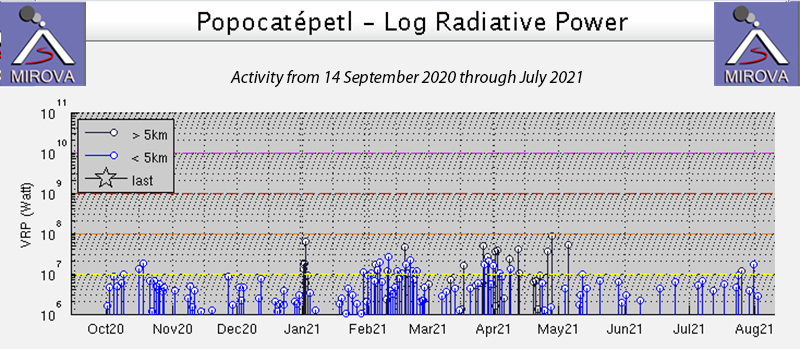 |
Figure 176. The MIROVA graph of thermal anomalies at Popocatepetl from 14 September 2020 through July 2021 shows steady, low-level, activity through April, followed by fewer anomalies through July. Courtesy of MIROVA. |
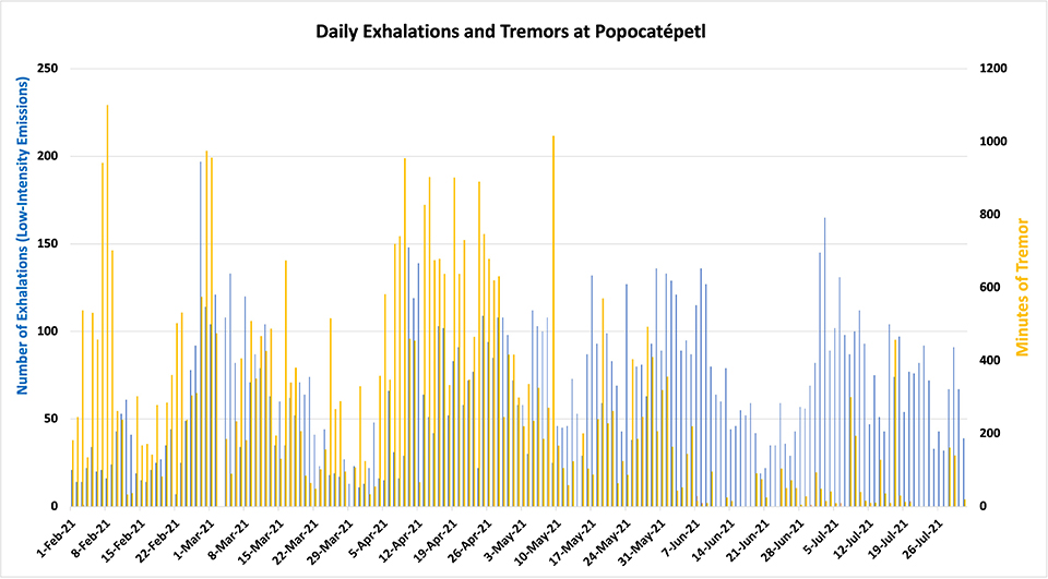 |
Figure 177. CENAPRED reported the number of daily ‘exhalations’ (in blue, left scale), and the number of minutes of tremor (in gold, right scale) at Popocatepetl each day during February-July 2021. The number of daily exhalations fluctuated throughout the period, but the minutes of tremor remained high through early May and then decreased. Data from CENAPRED daily reports. |
Water vapor, gas, and small quantities of ash were present in the tens of daily exhalations during February 2021. There was a wide range in the number of minutes of tremor each day from a low of 33 to a high of 1,101. On many days during the month, 1-3 explosions were recorded; CENAPRED reported an explosion on 7 February that sent an ash plume 2,000 m above the summit crater. Incandescence was observed on about half the nights of the month. A swarm of 24 volcano-tectonic (VT) earthquakes was reported overnight during 10-11 February with magnitudes in the 1.0-2.6 range. Thermal anomalies appeared inside the inner crater at the summit in Sentinel-2 satellite images on 5, 10, 15, 20, and 25 February. The images on 5 and 25 February also captured ash plumes (figure 178). Small but distinct SO2 emissions were also present in satellite imagery each day.
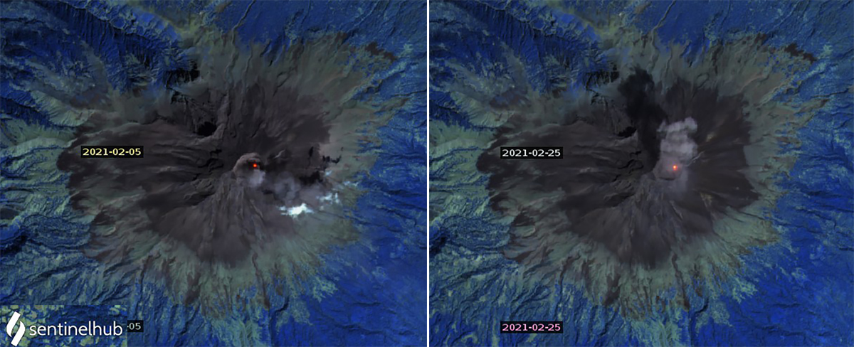 |
Figure 178. Thermal anomalies and ash emissions were both recorded in Sentinel-2 satellite images from Popocatepetl on 5 and 25 February 2021. Thermal anomalies were additionally recorded on 10, 15, and 20 February. Images use Atmospheric penetration rendering (bands 12, 11, 8a). Courtesy of Sentinel Hub Playground. |
Multiple daily VAAC reports from the Washington VAAC noted emissions drifting tens of kilometers in multiple directions at altitudes of 5.8-6.4 km throughout the month. On 1 February 2021 the Washington VAAC reported an ash emission at 5.8 km altitude drifting 20 km S (figure 179); on 3 February continuous diffuse ash emissions at the same altitude drifted 45 km SW of summit. On 6 February the emissions were drifting E at 6.1 km and the next day emissions at that altitude were fanning out NE and NW of the summit. On 13 February emissions were observed in both the webcam and satellite imagery extending 35 km E at 5.8 km altitude. A remnant ash cloud at 6.1 km altitude was located 175 km W of the summit on 23 February while a new emission was located 35 km NW at 6.4 km altitude. On 28 February a concentrated ash plume extended 45 km NNW of the summit while a diffuse plume extended 120 km NNW at 5.8 km altitude.
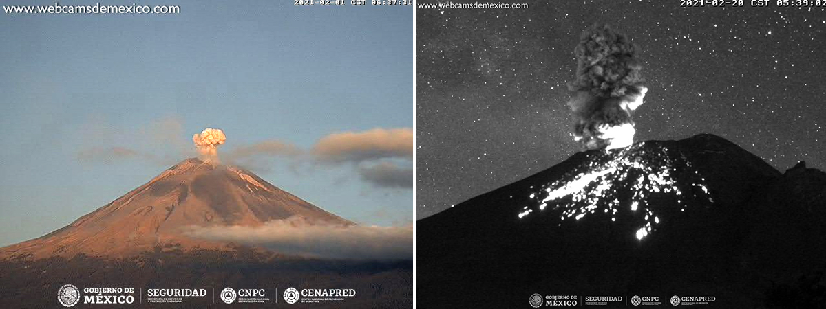 |
Figure 179. Ash emissions and incandescence at the summit occurred often at Popocatepetl during February 2021 including on 1 (left) and 20 (right) February. Courtesy of CENAPRED daily reports. |
During March 2021 the number of daily exhalations ranged widely from 11 to 133 and consisted of gas, water vapor, and small quantities of ash. The number of minutes of tremor ranged from a few tens to almost 1,000. Minor explosions and VT events occurred intermittently throughout the month. During an overflight on 6 March CENAPRED reported the dimensions of the internal crater as 360-390 m wide and 150-180 m deep, and it was covered with tephra (figure 180). There was no sign of a growing dome within the crater. Trace amounts of ashfall were reported on 13 March in the municipalities of Amecameca and Tlalmanalco, and again overnight 14-15 March in Amecameca. Incandescence was reported at night during 20-23 and 29-31 March. Minor explosions on 27 and 28 March produced plumes with low amounts of ash that rose 800-1,000 m and drifted N and NW. Very small but distinct SO2 plumes were measured in satellite data each day; thermal anomalies inside the summit crater were observed in Sentinel-2 images on 2, 12, 17, 22, and 27 March (figure 181). Multiple daily VAAC reports continued, but were more intermittent during the last third of the month. On 4 March an existing ash plume was moving SW at 6.1 km altitude 45 km from the summit when a new emission occurred that rose to 7 km altitude and extended 30 km WNW. The plume reported on 13 March was typical of many during the month, drifting NW as far as 150 km from the summit at 6.4 km altitude; they were frequently observed in both satellite data and with the webcam.
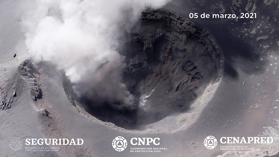 |
Figure 180. The summit crater at Popocatepetl was 360-390 m wide, 150-180 m deep and covered with tephra on 5 March 2021 when viewed during an overflight by government officials. Courtesy of CENAPRED daily report. |
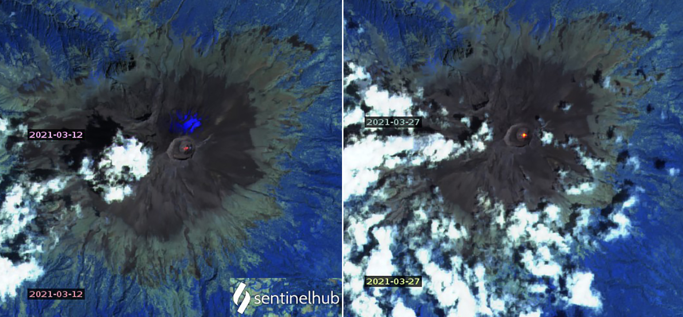 |
Figure 181. Thermal anomalies inside the summit crater of Popocatepetl were different shapes and intensities in Sentinel-2 images on 12 and 27 March 2021 shown here, and also on 2, 17, and 22 March. Images use Atmospheric penetration rendering (bands 12, 11, 8a). Courtesy of Sentinel Hub Playground. |
Daily exhalations ranging from 13-148 per day continued during April 2021. The emissions were primarily gas and water vapor, although intermittent events with small quantities of ash were frequent. Daily tremors ranged from 34-955 minutes in length. Incandescence was visible at the summit during 1-6 and 17-19 April. A moderate explosion overnight on 3-4 April produced incandescent ejecta that traveled up to 1 km down the slopes of the volcano and produced an ash plume that rose 1,200 m and drifted SE. The Washington VAAC reported the ash plume at 7.3 km altitude drifting 30 km E from the summit. Daily VAAC reports were issued for ash plumes that rose to 5.8-7 km altitude and were often visible up to 50 km from the summit. A very bright thermal anomaly appeared inside the summit crater in Sentinel-2 satellite imagery on 1 April, and a very faint one was present on 21 April. A few small to moderate plumes of SO2 were detected with satellite instruments during April, but most days the anomalies were small (figure 182).
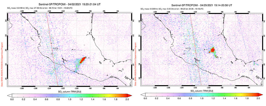 |
Figure 182. Moderate size SO2 plumes were measured at Popocatepetl intermittently throughout April 2021 including on 2 and 29 April. Courtesy of NASA Global Sulfur Dioxide Monitoring Page. |
Gas and small quantities of ash were typical of the 25-136 daily emissions throughout May 2021. Tens to hundreds of minutes of tremors were also reported each day. Thermal anomalies at the center of the summit crater were distinct in Sentinel-2 satellite images on 6, 26, and 31 May. Moderate SO2 plumes were common during the first half of May but diminished during the second half. Significantly fewer ash emissions were reported by the Washington VAAC than during the previous few months. Ash plumes during 1-4 May rose to 5.8-6.4 km altitude and drifted NE up to 65 km from the summit. The ash plumes reported during 7-9 May rose to 5.8 km and drifted mostly E. Additional plumes during 14-15, 18, 20-22, 28-29 May and 31 May-1 June rose to 5.8-6.1 km and drifted for a few hours in multiple directions before dissipating (figure 183). Trace amounts of ash fell in Tetela del Volcán during the afternoon of 28 May.
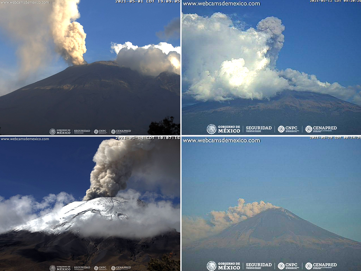 |
Figure 183. Ash plumes at Popocatepetl were recorded in webcams on 2, 12, 15, and 29 May 2021. Courtesy of CENAPRED daily reports. |
Ash emissions were only reported twice during June and four times during July 2021 by the Washington VAAC. They rose to 6.1 km on 11-12 June and 5.8 km on 17 June, drifting NW both times. Similar emissions also occurred during 7, 11-12, 16-18, and 22 July. Exhalations continued to be reported daily at the same rate as May, but there were fewer minutes of tremor both months, and no tremors occurred on nine days of June and ten days of July. Small thermal anomalies appeared in Sentinel satellite images in the same location as earlier images at the center of the summit crater on 10 June, and 10 and 25 July. Small but distinct SO2 plumes were recorded throughout both months, with only a few days of larger emissions measured by the satellite instruments. CENAPRED reported incandescent ejecta visible a short distance from the crater on the morning of 17 July and an explosion on 21 July that produced an ash plume that rose 800 m and drifted W. An explosion on 22 July produced incandescent ejecta and an ash plume that rose 900 m above the summit and also drifted W (figure 184). Ashfall was reported in the communities of Tlalnepantla, Totolapan, and Huitzilac in the state of Morelos. Another explosion on 24 July sent incandescent fragments down the N flank and an ash plume to 800 m high that drifted NW.
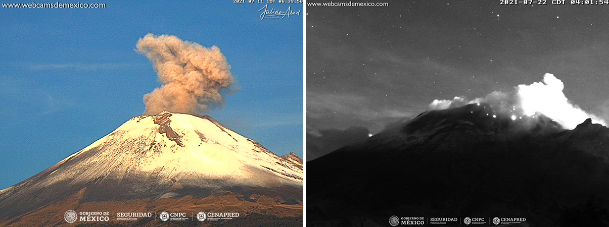 |
Figure 184. Ash plumes and incandescent ejecta were less frequent at Popocatepetl during July 2021 than during previous months, but were still recorded a number of times, including on 12 and 29 July. Courtesy of CENAPRED daily reports. |
Geological Summary. Volcán Popocatépetl, whose name is the Aztec word for smoking mountain, rises 70 km SE of Mexico City to form North America's 2nd-highest volcano. The glacier-clad stratovolcano contains a steep-walled, 400 x 600 m wide crater. The generally symmetrical volcano is modified by the sharp-peaked Ventorrillo on the NW, a remnant of an earlier volcano. At least three previous major cones were destroyed by gravitational failure during the Pleistocene, producing massive debris-avalanche deposits covering broad areas to the south. The modern volcano was constructed south of the late-Pleistocene to Holocene El Fraile cone. Three major Plinian eruptions, the most recent of which took place about 800 CE, have occurred since the mid-Holocene, accompanied by pyroclastic flows and voluminous lahars that swept basins below the volcano. Frequent historical eruptions, first recorded in Aztec codices, have occurred since Pre-Columbian time.
Information Contacts: Centro Nacional de Prevención de Desastres (CENAPRED), Av. Delfín Madrigal No.665. Coyoacan, México D.F. 04360, México (URL: http://www.cenapred.unam.mx/, Daily Report Archive https://www.gob.mx/cenapred/archivo/articulos); Sentinel Hub Playground (URL: https://www.sentinel-hub.com/explore/sentinel-playground); MIROVA (Middle InfraRed Observation of Volcanic Activity), a collaborative project between the Universities of Turin and Florence (Italy) supported by the Centre for Volcanic Risk of the Italian Civil Protection Department (URL: http://www.mirovaweb.it/); NASA Global Sulfur Dioxide Monitoring Page, Atmospheric Chemistry and Dynamics Laboratory, NASA Goddard Space Flight Center (NASA/GSFC), 8800 Greenbelt Road, Goddard, Maryland, USA (URL: https://so2.gsfc.nasa.gov/).