Report on Kadovar (Papua New Guinea) — September 2021
Bulletin of the Global Volcanism Network, vol. 46, no. 9 (September 2021)
Managing Editor: Edward Venzke.
Edited by Kadie L. Bennis.
Kadovar (Papua New Guinea) Intermittent ash plumes and thermal anomalies during January-August 2021
Please cite this report as:
Global Volcanism Program, 2021. Report on Kadovar (Papua New Guinea) (Bennis, K.L., and Venzke, E., eds.). Bulletin of the Global Volcanism Network, 46:9. Smithsonian Institution. https://doi.org/10.5479/si.GVP.BGVN202109-251002
Kadovar
Papua New Guinea
3.608°S, 144.588°E; summit elev. 365 m
All times are local (unless otherwise noted)
Kadovar, located in the Bismark Sea offshore from the island of New Guinea about 25 km NNE from the mouth of the Sepik River, has been erupting since January 2018 with intermittent ash and gas-and-steam plumes along with weak summit thermal anomalies (BGVN 46:01). Similar activity continued during this reporting period of January through August 2021 based on information from the Darwin Volcanic Ash Advisory Center (VAAC) and satellite data.
Relatively low activity during this reporting period consisted of primarily weak thermal anomalies in the summit crater and small gas-and-ash emissions (figure 59). On 3 and 7 January discrete ash puffs seen in HIMAWARI-8 satellite images rose to 1.5 km altitude and drifted SW and W, respectively; both dissipated within six hours. Ash plumes on 5 and 6 January rose to 1.8 km altitude and drifted NW. Occasional ash plumes were detected during March, rising to 1.5 km altitude and drifting W, based on satellite imagery. On 15 April an ash plume that rose to 1.8 km altitude and drifted W was accompanied by a small sulfur dioxide plume, according to the TROPOMI instrument on the Sentinel-5P satellite (figure 60). On 12 and 19 June, 4 July, and 1, 19, and 27 August small ash plumes that rose to 1.2-1.5 km altitude drifted W and NW.
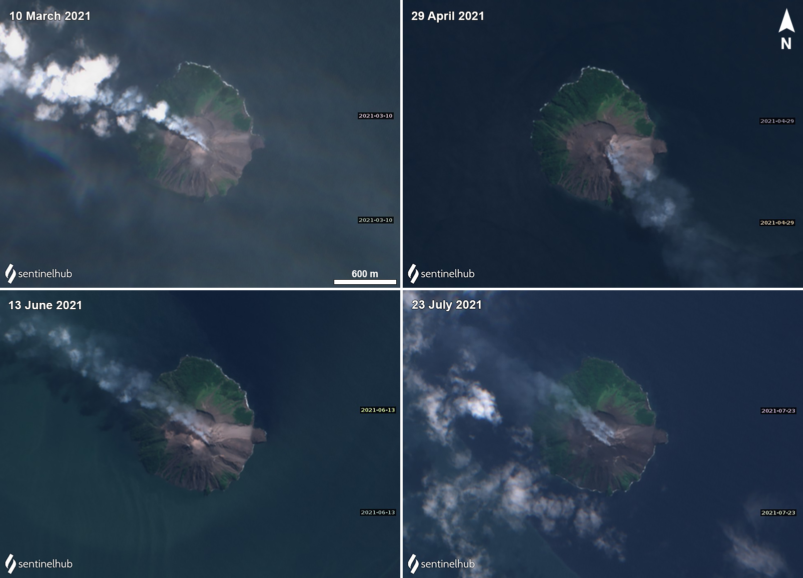 |
Figure 59. Sentinel-2 satellite images showing intermittent gas-and-steam plumes rising from Kadovar and drifting downwind on 10 March (top left), 29 April (top right), 13 June (bottom left), and 23 July (bottom right) 2021. Images with “Natural color” (bands 4, 3, 2) rendering. Courtesy of Sentinel Hub Playground. |
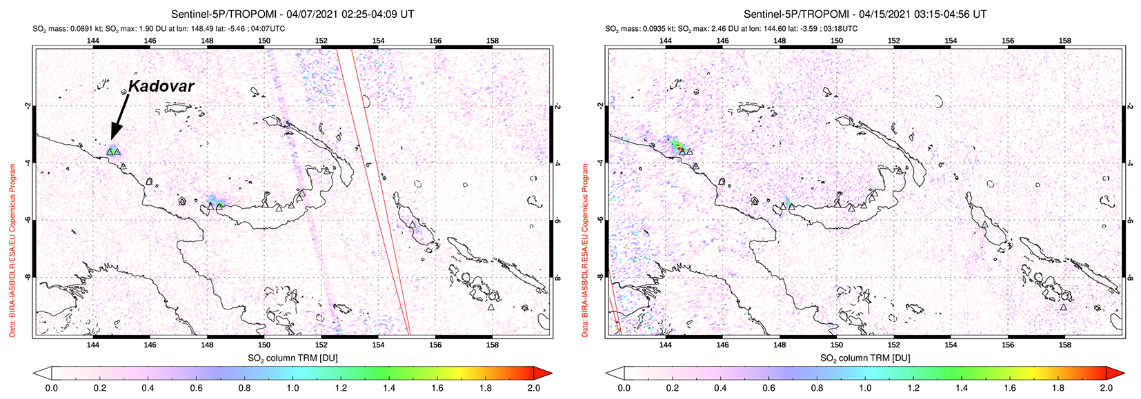 |
Figure 60. Small sulfur dioxide emissions were detected at Kadovar on 7 (left) and 15 (right) April 2021 with the TROPOMI instrument on the Sentinel-5P satellite, accompanying small ash plumes. Courtesy of NASA Global Sulfur Dioxide Monitoring Page. |
MIROVA (Middle InfraRed Observation of Volcanic Activity) analysis of MODIS satellite data shows weak clusters of thermal anomalies during January through March and May through August 2021 (figure 61). Stronger anomalies were detected during July through August, which was also reflected in Sentinel-2 infrared satellite imagery (figure 62).
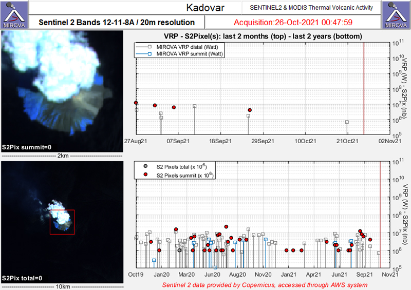 |
Figure 61. Occasional thermal anomalies (red dots) were detected at the summit of Kadovar during January through August 2021, as recorded by the Sentinel-2 MODIS Thermal Volcanic Activity data (bands 12, 11, 8A). A higher concentration of strong anomalies was detected during May and July-August. Courtesy of MIROVA. |
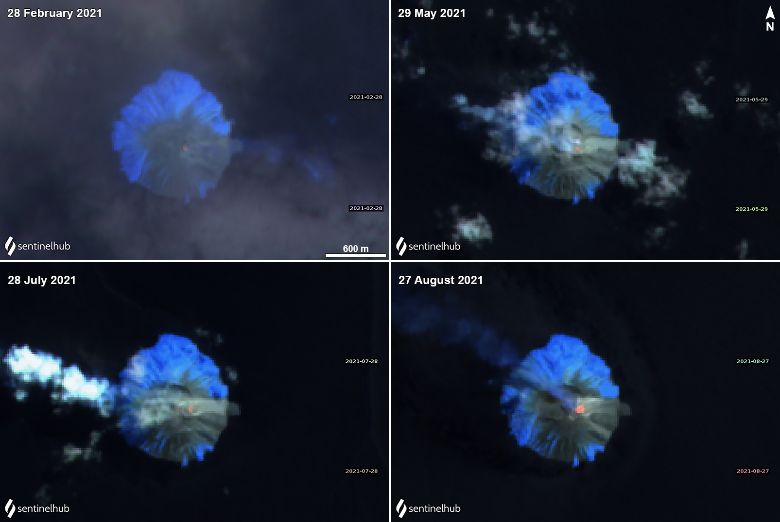 |
Figure 62. Sentinel-2 infrared satellite images showing a weak thermal anomaly in the summit crater of Kadovar on 28 February (top left), 29 May (top right), 29 July (bottom left), and 27 August (bottom right), accompanied by white gas-and-steam emissions that drifted generally SE and W. A significant thermal anomaly was noted on 27 August. Images with “Atmospheric penetration” (bands 12, 11, 8A) rendering. Courtesy of Sentinel Hub Playground. |
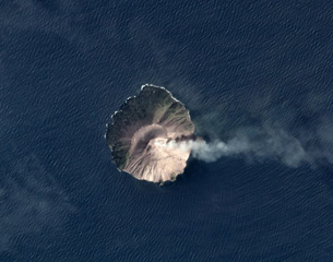
Geological Summary. The 2-km-wide island of Kadovar is the emergent summit of a Bismarck Sea stratovolcano of Holocene age. It is part of the Schouten Islands, and lies off the coast of New Guinea, about 25 km N of the mouth of the Sepik River. Prior to an eruption that began in 2018, a lava dome formed the high point of the andesitic volcano, filling an arcuate landslide scarp open to the south; submarine debris-avalanche deposits occur in that direction. Thick lava flows with columnar jointing forms low cliffs along the coast. The youthful island lacks fringing or offshore reefs. A period of heightened thermal phenomena took place in 1976. An eruption began in January 2018 that included lava effusion from vents at the summit and at the E coast.
Information Contacts: Darwin Volcanic Ash Advisory Centre (VAAC), Bureau of Meteorology, Northern Territory Regional Office, PO Box 40050, Casuarina, NT 0811, Australia (URL: http://www.bom.gov.au/info/vaac/); MIROVA (Middle InfraRed Observation of Volcanic Activity), a collaborative project between the Universities of Turin and Florence (Italy) supported by the Centre for Volcanic Risk of the Italian Civil Protection Department (URL: http://www.mirovaweb.it/); Sentinel Hub Playground (URL: https://www.sentinel-hub.com/explore/sentinel-playground).