Report on Ibu (Indonesia) — September 2021

Bulletin of the Global Volcanism Network, vol. 46, no. 9 (September 2021)
Managing Editor: Benjamin Andrews.
Edited by Kadie L. Bennis.
Ibu (Indonesia) Intermittent low-level ash plumes, light ashfall, and thermal anomalies during January-August 2021
Please cite this report as:
Global Volcanism Program, 2021. Report on Ibu (Indonesia) (Bennis, K.L., and Andrews, B., eds.). Bulletin of the Global Volcanism Network, 46:9. Smithsonian Institution. https://doi.org/10.5479/si.GVP.BGVN202109-268030
Ibu
Indonesia
1.488°N, 127.63°E; summit elev. 1325 m
All times are local (unless otherwise noted)
Ibu is located along the NW coast of Halmahera Island in Indonesia and contains an inner crater measuring 1-km-wide and 400 m deep, an outer crater that measures 1.2-km-wide, and is breached on the N side. The first observed and recorded eruption occurred in 1911 and consisted of a small explosion in the summit crater. The current eruption period began in April 2008 and has recently been characterized by daily ash emissions, explosions, and thermal anomalies (BGVN 46:01). This report covers similar activity of white-and-gray emissions, ash plumes, and light ashfall during January through August 2021 using information from the Pusat Vulkanologi dan Mitigasi Bencana Geologi (PVMBG, also known as Indonesian Center for Volcanology and Geological Hazard Mitigation, CVGHM), Darwin Volcanic Ash Advisory Centre (VAAC), and various satellite data. The Volcano Alert Level remained at a 2 (on a scale of 1-4), and the public was warned to stay at least 2 km away from the active crater and 3.5 km away on the N side.
Activity throughout January-August 2021 was consistent and similar to that of the previous year. Between 35 and 115 daily explosions were detected during the reporting period, the latter of which occurred on 7 February, and produced white-and-gray emissions that rose 200-1,000 m above the crater and drifted in different directions, according to PVMBG. Occasional larger explosions were reported in VONA and VAAC notices. According to the MIROVA plot (Log Radiative Power), thermal activity was consistent, yet low in power from January through August; during May, the anomalies were at their lowest strength (figure 31). The MODVOLC algorithm detected ten thermal alerts during this period, with one each on 1 February, 9 March, 22 April, 2 and 27 June, 29 July, and 12 August, and three on 23 August 2021. Some of this thermal activity was detected in Sentinel-2 infrared satellite images on clear weather days (figure 32).
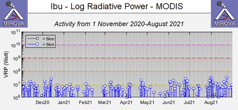 |
Figure 31. Constant low-power thermal anomalies were detected at the summit crater of Ibu during January through August 2021, as shown by the MIROVA graph (Log Radiative Power). Courtesy of MIROVA. |
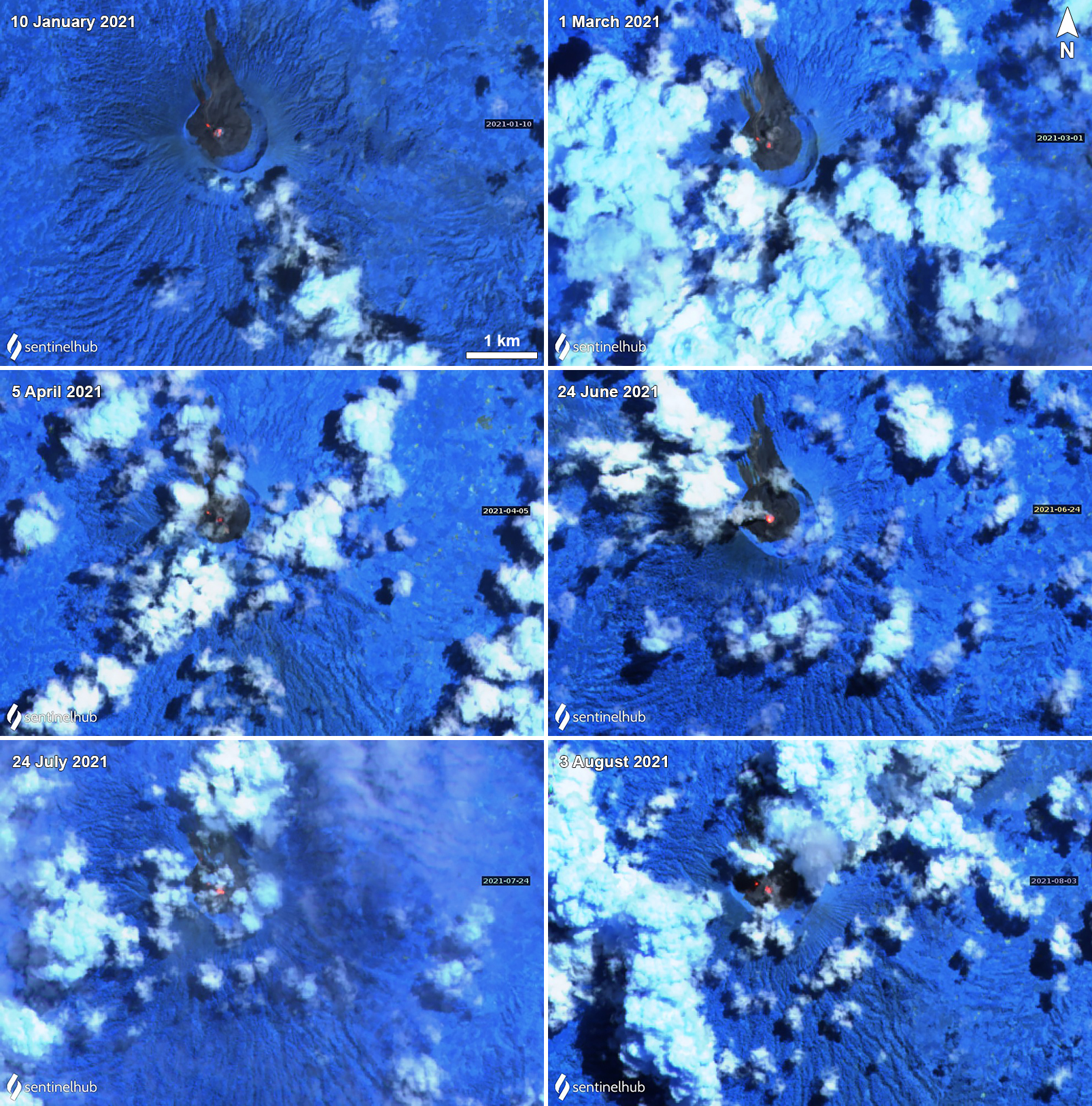 |
Figure 32. Thermal anomalies persisted in the summit crater of Ibu during January through August 2021. One strong central anomaly was commonly accompanied by a smaller one slightly to the NW, as shown on 10 January (top left), 1 March (top right), 5 April (middle left), and 8 August (bottom right) 2021. Images using “Atmospheric penetration” (bands 12, 11, 8A) rendering. Courtesy of Sentinel Hub Playground. |
The Darwin VAAC detected a single minor ash plume on 7 January that rose to 1.8 km altitude, or about 500 m above the summit, and drifted N, based on a ground report. This information was also reported in a PVMBG VONA notice that stated the ash plume occurred at 1055. Similar low-level ash plumes persisted in February; during 5-6 February ash plumes rose to 1.8-2.4 km and drifted W and SW, based on HIMAWARI-8 satellite imagery. An ash plume rose 800 m above the crater on 8 February on 1101, according to a VONA notice. PVMBG reported that during 16-17 February a total of 88 eruptive events occurred. Consecutive ash plumes on 24, 25, and 26 February rose 500, 800, and 800 m above the crater, respectively (figure 33).
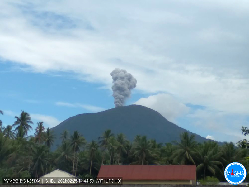 |
Figure 33. An ash plume rose from the summit of Ibu on 25 February 2021 to a height of 800 m. Courtesy of MAGMA Indonesia. |
Similar intermittent ash emissions continued during March and April. On 3, 9, and 12 March an ash plume rose to 2.1 km and drifted S, according to Darwin VAAC notices (figure 34). During 14, 21, 25, and 31 March ash plumes rose 600-1,000 m above the crater, based on VONA notices and PVMBG daily reports. A thermal anomaly was detected in satellite imagery near the summit on 22 March and 6-7 April, according to a Darwin VAAC report. Accompanying the latter thermal anomaly, at 1812 a VONA notice reported an ash plume rose 400 m above the crater. An ash plume rose 800 m above the crater on 20 April at 1819 and another detected on 22 April at 1258 rose 1,000 m above the crater. On 26 April an ash plume rose 600 m above the crater and drifted N.
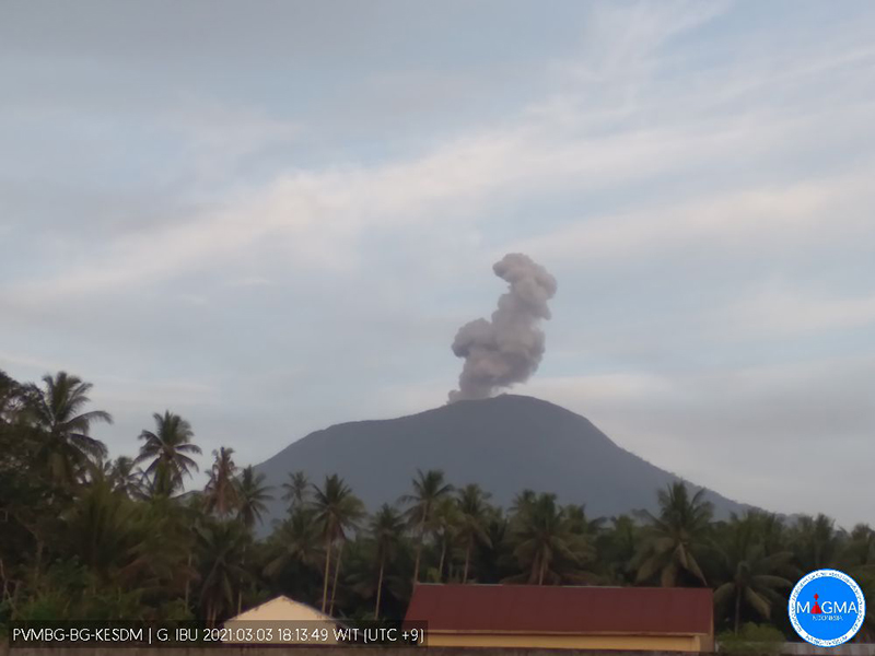 |
Figure 34. Intermittent ash plumes rising above the summit of Ibu were recorded multiple times in webcam images during March and April 2021, as shown here on 3 March 2021 rising to 2.1 km altitude and drifting S. Courtesy of MAGMA Indonesia. |
During May and June, activity remained consistent with intermittent ash emissions. On 3 and 12 May an ash plume rose to 1.8 km altitude and drifted W and NW, based on HIMAWARI-8 satellite imagery. Ash plumes were visible during 16 (figure 35) and 17 May, the latter of which occurred at 1039 and rose ~750 m above the crater and drifted N. During the afternoon and evening of 19 May, light ashfall was reported in residential areas from the Naga village (4.8 km SW) to the Tongute village of Ternate (10 km W). On 6 and 10 June ash emissions rose to 1.8 km altitude and extended N. Rock avalanches were recorded through seismic data during 11-13 June, though they were not visually confirmed, according to PVMBG. During 18-20 June 63 eruptive events per day were detected.
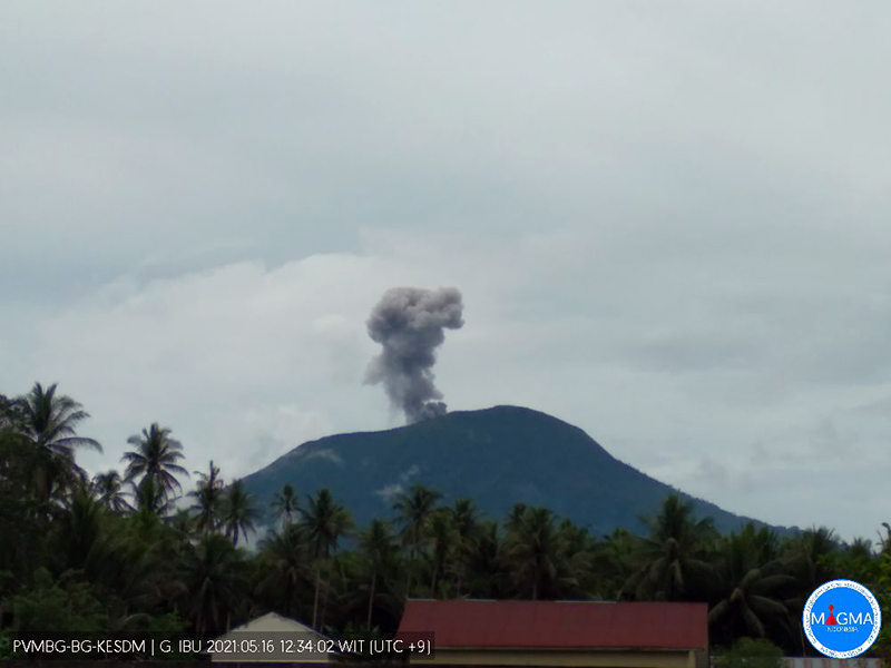 |
Figure 35. Ash plumes from the summit of Ibu continued during May and June 2021, as seen here on 16 May 2021. Courtesy of MAGMA Indonesia. |
Low ash emissions continued during July and August; on 10 July at 0719 an ash plume rose 800 m above the crater and the next day, light ashfall was reported in residential areas to the W of the volcano, though it was not specified how far. During 14-15 and 17 July white-and-gray emissions rose 200-800 m above the crater and drifted N, S, and W; light ashfall was again observed in residential areas to the W, and loud rumblings were heard as far as the Ibu observation post. On 28 July an ash plume rose to 2.4 km altitude and extended NE. During 1-2 August an ash plume rose to 1.8-2.1 km altitude. An ash plume on 18 August was reported at 0810 rising 800 m above the crater and drifting W. An ash plume on 22 August rose to 1.8 km altitude and was accompanied by a thermal anomaly that was identified in satellite imagery.
Geological Summary. The truncated summit of Gunung Ibu stratovolcano along the NW coast of Halmahera Island has large nested summit craters. The inner crater, 1 km wide and 400 m deep, has contained several small crater lakes. The 1.2-km-wide outer crater is breached on the N, creating a steep-walled valley. A large cone grew ENE of the summit, and a smaller one to the WSW has fed a lava flow down the W flank. A group of maars is located below the N and W flanks. The first observed and recorded eruption was a small explosion from the summit crater in 1911. Eruptive activity began again in December 1998, producing a lava dome that eventually covered much of the floor of the inner summit crater along with ongoing explosive ash emissions.
Information Contacts: Pusat Vulkanologi dan Mitigasi Bencana Geologi (PVMBG, also known as Indonesian Center for Volcanology and Geological Hazard Mitigation, CVGHM), Jalan Diponegoro 57, Bandung 40122, Indonesia (URL: http://www.vsi.esdm.go.id/); MAGMA Indonesia, Kementerian Energi dan Sumber Daya Mineral (URL: https://magma.esdm.go.id/v1); Darwin Volcanic Ash Advisory Centre (VAAC), Bureau of Meteorology, Northern Territory Regional Office, PO Box 40050, Casuarina, NT 0811, Australia (URL: http://www.bom.gov.au/info/vaac/); MIROVA (Middle InfraRed Observation of Volcanic Activity), a collaborative project between the Universities of Turin and Florence (Italy) supported by the Centre for Volcanic Risk of the Italian Civil Protection Department (URL: http://www.mirovaweb.it/); Hawai'i Institute of Geophysics and Planetology (HIGP) - MODVOLC Thermal Alerts System, School of Ocean and Earth Science and Technology (SOEST), Univ. of Hawai'i, 2525 Correa Road, Honolulu, HI 96822, USA (URL: http://modis.higp.hawaii.edu/); Sentinel Hub Playground (URL: https://www.sentinel-hub.com/explore/sentinel-playground).