Report on Telica (Nicaragua) — September 2021

Bulletin of the Global Volcanism Network, vol. 46, no. 9 (September 2021)
Managing Editor: Edward Venzke.
Research and preparation by Paul Berger.
Telica (Nicaragua) Weak explosions and minor ash plumes during April-July 2021
Please cite this report as:
Global Volcanism Program, 2021. Report on Telica (Nicaragua) (Venzke, E., ed.). Bulletin of the Global Volcanism Network, 46:9. Smithsonian Institution. https://doi.org/10.5479/si.GVP.BGVN202109-344040
Telica
Nicaragua
12.606°N, 86.84°W; summit elev. 1036 m
All times are local (unless otherwise noted)
A series of weak ash explosions during 30 November-8 December resulted in ashfall in neighboring communities (BGVN 46:03). The following report describes activity between March and August 2021, based on monthly and special bulletins published by the Instituto Nicaragüense de Estudios Territoriales (INETER) and satellite images.
According to INETER, the volcano was quiet during March through 21 April, when two small gas-and-ash explosions occurred on that date at 0527 and 0610. Ash rose about 400 m above the crater and fell on the volcano’s slopes. Satellite images during the last week of April showed dark emissions.
On 1 May 2021 a Sentinel-2 satellite image showed a weak ash plume extending W over the crater. Weak ash plumes were also recorded by Sentinel-2 on 3 May and 6 May. Then, according to INETER, a total of 60 weak explosions occurred during 6-8 May. The plumes reached a height of 300 m and drifted S and SW, with ash falling primarily on the volcano’s slopes (figure 56). Sentinel-2 images showed weaker dark emissions through the rest of May. INETER reported 19 more weak explosions during 16-17 May and 16 explosions on 22 May, starting at 0508. On 24 May, 15 new explosions occurred, averaging once every 15 minutes. Gas-and-ash columns reached 250 m above the crater, and tephra from the plumes dropped back into the crater. After the activity on 5 May, INETER scientists visited the volcano and observed strong degassing (figure 57).
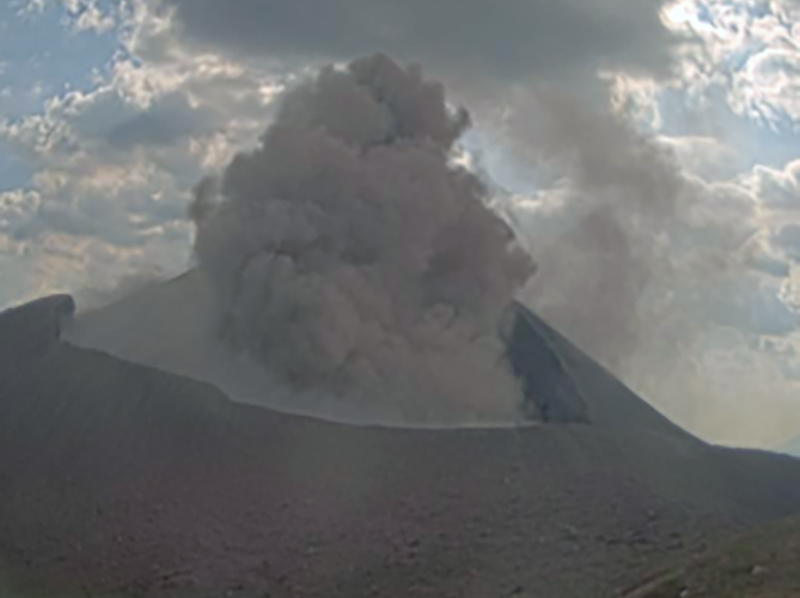 |
Figure 56. Webcam image showing an ash explosion at Telica on 7 May 2021. Courtesy of INETER (Boletín mensual Sismos y Volcanes de Nicaragua, Mayo, 2021). |
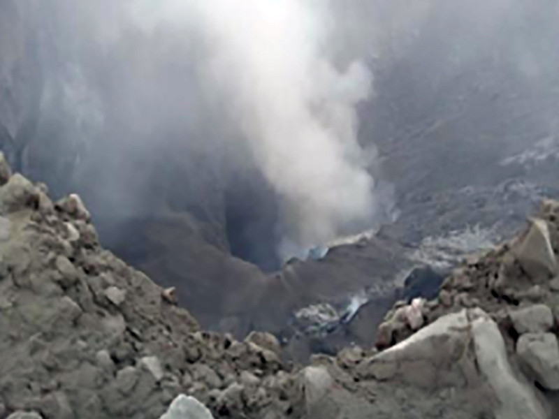 |
Figure 57. Degassing from the summit crater of Telica observed during a field visit after gas-and-ash emissions on 5 May 2021. Courtesy of INETER (Boletín mensual Sismos y Volcanes de Nicaragua, Mayo, 2021). |
According to INETER, on 20-21 June, four small gas and ash explosions occurred. Ash rose to a maximum height of 150 m above the crater and fell on the NW slope. Sentinel-2 images recorded only modest emissions during these explosions, including a dark plume extending S on 25 June (figure 58). INETER reported that on 29 June gas-and-ash emissions began at 0500, with ash reaching a maximum height of about 200 m above the crater and falling on the SW slope.
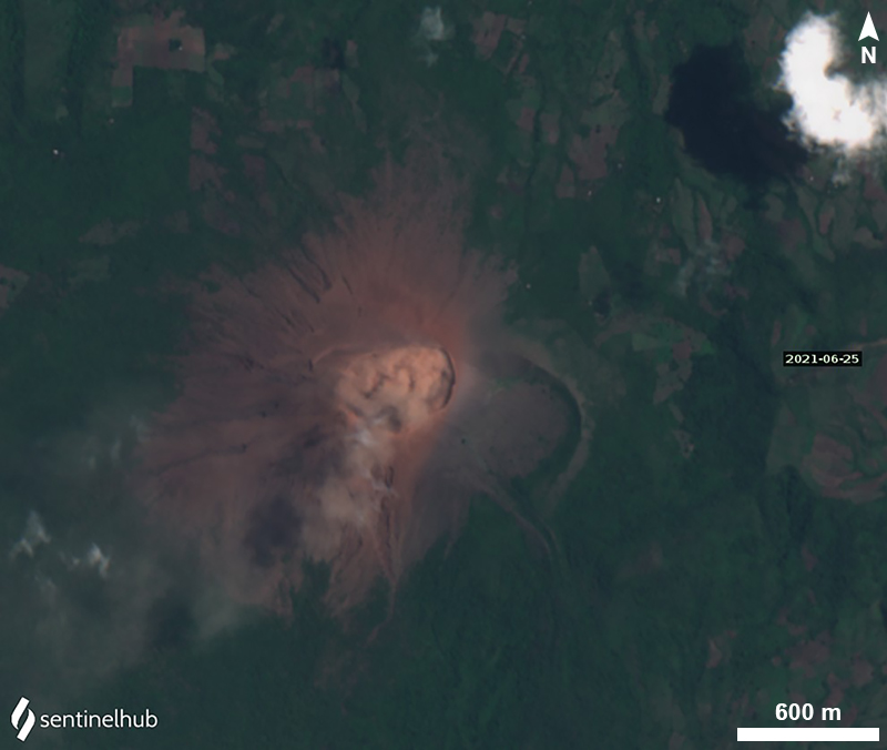 |
Figure 58. Ash plume on 25 June 2021, as captured by a Sentinel-2 satellite (natural color, bands 4, 3, 2). Courtesy of Sentinel Hub Playground. |
The Washington Volcanic Ash Advisory Center (VAAC) reported ash plumes during 2-3 July. A few discrete emissions and ash near the crater were visible in webcam images on 2 July, and possible diffuse ash near and W of the crater was identified in satellite images. Plumes likely rose to about 200-500 m above the crater. Another steam-and-ash plume drifted SW and then turned N. On 3 July possible ash plumes rose about 500 m above the crater and drifted WSW. Sentinel-2 imagery showed an ash plume within the crater on 20 July. No additional ash plumes were detected or reported through August.
Additional observations. According to INETER, SO2 emissions measured with Mobile-DOAS using 7-8 transects ranged from an average of 47 metric tons/day (April) to 286 metric tons/day (August). The monthly values were generally lower during the first half of 2021 compared to March-December 2020 (figure 59). Seismic activity diminished every month between April (85,198 seismic events) and July (47,762 events), continuing a decreasing trend from January 2021 (about 140,000 seismic events). Most events during April-July were hybrid earthquakes. Tremor was 50-70 RSAM units in March and 10-30 RSAM units during April-July.
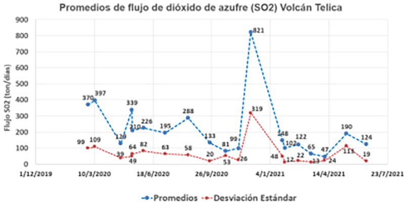 |
Figure 59. Monthly SO2 levels at Telica during March 2020-June 2021. Blue dashed line shows average value (promedios); red dashed line is the standard deviation (desviación estándar). Courtesy of INETER (Boletín mensual Sismos y Volcanes de Nicaragua, Junio, 2021). |
Geological Summary. Telica, one of Nicaragua's most active volcanoes, has erupted frequently since the beginning of the Spanish era. This volcano group consists of several interlocking cones and vents with a general NW alignment. Sixteenth-century eruptions were reported at symmetrical Santa Clara volcano at the SW end of the group. However, its eroded and breached crater has been covered by forests throughout historical time, and these eruptions may have originated from Telica, whose upper slopes in contrast are unvegetated. The steep-sided cone of Telica is truncated by a 700-m-wide double crater; the southern crater, the source of recent eruptions, is 120 m deep. El Liston, immediately E, has several nested craters. The fumaroles and boiling mudpots of Hervideros de San Jacinto, SE of Telica, form a prominent geothermal area frequented by tourists, and geothermal exploration has occurred nearby.
Information Contacts: Instituto Nicaragüense de Estudios Territoriales (INETER), Apartado Postal 2110, Managua, Nicaragua (URL: http://www.ineter.gob.ni/); MIROVA (Middle InfraRed Observation of Volcanic Activity), a collaborative project between the Universities of Turin and Florence (Italy) supported by the Centre for Volcanic Risk of the Italian Civil Protection Department (URL: http://www.mirovaweb.it/); Hawai'i Institute of Geophysics and Planetology (HIGP) - MODVOLC Thermal Alerts System, School of Ocean and Earth Science and Technology (SOEST), Univ. of Hawai'i, 2525 Correa Road, Honolulu, HI 96822, USA (URL: http://modis.higp.hawaii.edu/); NASA Global Sulfur Dioxide Monitoring Page, Atmospheric Chemistry and Dynamics Laboratory, NASA Goddard Space Flight Center (NASA/GSFC), 8800 Greenbelt Road, Goddard MD, USA (URL: https://so2.gsfc.nasa.gov/); Sentinel Hub Playground (URL: https://www.sentinel-hub.com/explore/sentinel-playground); Washington Volcanic Ash Advisory Center (VAAC), Satellite Analysis Branch (SAB), NOAA/NESDIS OSPO, NOAA Science Center Room 401, 5200 Auth Rd, Camp Springs, MD 20746, USA (URL: www.ospo.noaa.gov/Products/atmosphere/vaac).