Report on Sabancaya (Peru) — October 2021

Bulletin of the Global Volcanism Network, vol. 46, no. 10 (October 2021)
Managing Editor: Edward Venzke.
Edited by A. Elizabeth Crafford.
Sabancaya (Peru) Daily explosions, ash emissions, and thermal anomalies from dome during April-September 2021
Please cite this report as:
Global Volcanism Program, 2021. Report on Sabancaya (Peru) (Crafford, A.E., and Venzke, E., eds.). Bulletin of the Global Volcanism Network, 46:10. Smithsonian Institution. https://doi.org/10.5479/si.GVP.BGVN202110-354006
Sabancaya
Peru
15.787°S, 71.857°W; summit elev. 5960 m
All times are local (unless otherwise noted)
Although tephrochronology has dated activity at Sabancaya back several thousand years, renewed activity that began in 1986 was the first recorded since 1784. A new period of explosive activity that began in November 2016 has been characterized by pulses of ash emissions with some plumes exceeding 10 km altitude, frequent thermal anomalies, and significant SO2 plumes. Daily ash emissions and high levels of SO2 continued during April-September 2021, the period covered in this report. The Observatorio Vulcanologico INGEMMET (OVI) reported daily on numbers of explosions, ash plume heights and directions of drift, seismicity, ashfall, and other activity; IGP (Instituto Geophysico del Peru) issued weekly reports of activity.
Activity at Sabancaya during April-September 2021 consisted of tens of daily explosions with dense gas-and-ash plumes, strong SO2 emissions, and persistent thermal anomalies from the growing dome at the summit crater. Ash plumes rose 1-2 km above the summit on most days; higher plumes occasionally reached 2.5-3.0 km. Ash most commonly drifted E and SE but there was significant variation in the wind direction. Ashfall was reported in communities around the volcano on multiple days each month except September. The Buenos Aires Volcanic Ash Advisory Center (VAAC) issued three or four daily reports of ongoing ash emissions throughout the period. The plumes rose to 6.4-8.2 km altitude and drifted in various directions, often visible in satellite imagery. Minor inflation was reported on the N flank near Hualca Hualca throughout the period.
Moderate levels of thermal energy were reported by the MIROVA project during April-September 2021 with minor fluctuations throughout the period (figure 103). The MODVOLC system reported seven thermal alerts in April, two in May, three in June, eleven in July, six in August, and two in September. Thermal anomalies and ash emissions were visible in Sentinel-2 satellite images multiple times each month (figure 104). Moderate to strong SO2 emissions were recorded virtually every day during the period by the TROPOMI instrument on the Sentinel-5P satellite (figure 105).
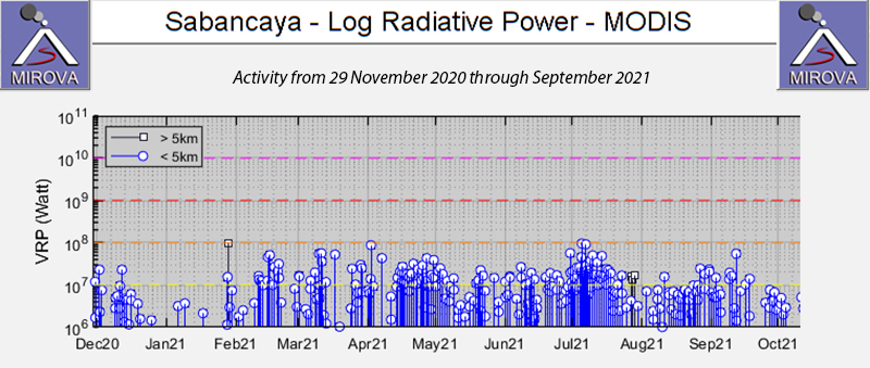 |
Figure 103. Thermal anomalies persisted at moderate levels with minor fluctuations throughout the period of April-September 2021 discussed in this report. Courtesy of MIROVA. |
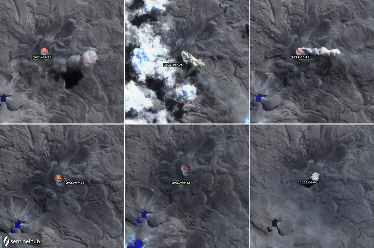 |
Figure 104. Sentinel-2 satellite images of Sabancaya showed thermal anomalies within the summit crater on multiple days every month during April-September 2021. Multiple hotspots within the crater were often visible. In addition, dense pulses of ash often rose from areas around the crater and drifted in various directions. Images use Atmospheric penetration rendering (bands 12, 11, 8a). Courtesy of Sentinel Hub Playground. |
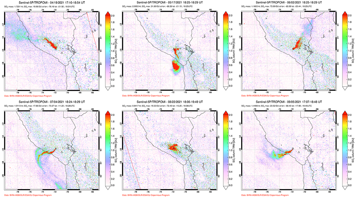 |
Figure 105. High levels of SO2 emissions from Sabancaya were recorded by the TROPOMI instrument on the Sentinel-5P satellite during April-September 2021, SO2 DU (Dobson Unit) density values were greater than 2 every day. Examples of the larger plumes each month are shown here; the date is along the top of each image. Courtesy of NASA Global Sulfur Dioxide Monitoring Page. |
Thermal anomalies were present inside the summit crater on 9, 19, 24, and 29 April 2021. Dense ash plumes rose 800-2,800 m above the crater rim from the 37-87 daily explosions. Intermittent ash plumes were reported daily by the Buenos Aires VAAC at 7.0-8.2 km altitude, drifting in multiple directions. Strong winds produced an ash plume that was visible in satellite imagery 100 km SE on 24 April (figure 106). Ashfall was reported on 12 days in different communities. Huanca reported ashfall on 6, 12, and 13 April, and it was noted in Madrigal and Pinchollo on 15, 17, 19, and 21 April. During 16-19 April ash was reported in Cabanaconde; it fell in Achoma Maca on 19 and 21 April, in Huambo on 20 April, and in Anexo de Salla on 25-26 April.
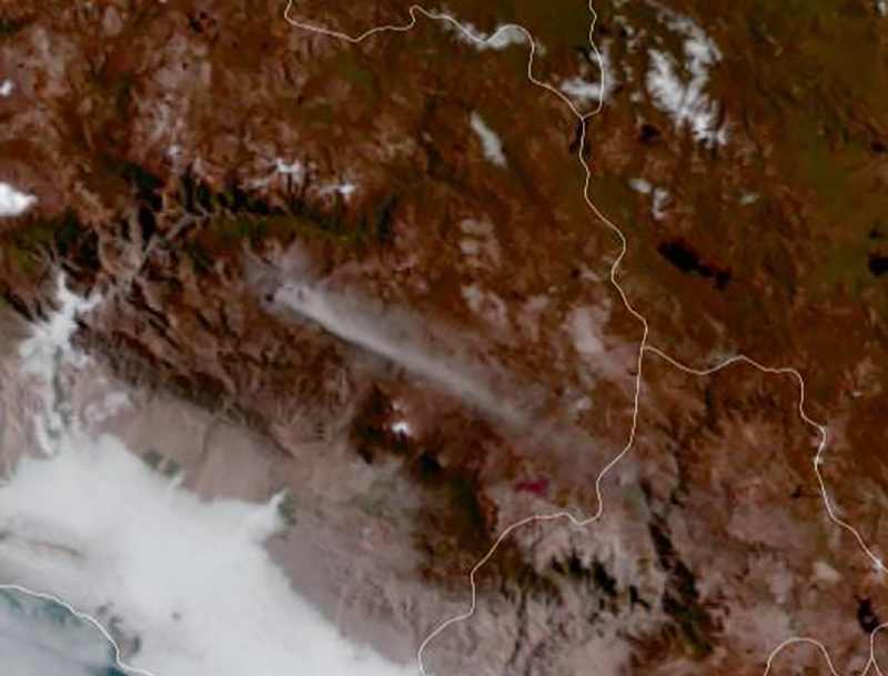 |
Figure 106. A GOES-16 satellite image from 24 April 2021 shows ash drifting 100 km SE from Sabancaya. Courtesy of OVI-INGEMMET (Reporte de actividad volcánica No. SAB111 2021, 25 de abril de 2021, 08:00 horas, Últimas 24 horas). |
Ash emissions from 43-75 daily explosions continued throughout May 2021 rising as high as 3.2 km above the summit, with ashfall reported in Madrigal and Pinchollo on 1 May and in Cabanaconde the next day. Huanca reported ashfall on 10 May, and Chivay, Achoma, Maca, and Madrigal reported it on 16 May. The next day ash fell in Chivay, Ichupampa, and Coporaque. Small amounts of ash were reported in Los Anexos de Pillones and Vincocaya in the district of San Antonio de Chuca on 19 and 20 May. Achoma and Yanque reported ashfall on 22 May. Ash plumes rose from multiple different areas of the summit crater on several occasions (figure 107). The Buenos Aires VAAC reported that daily ash emissions rose to 6.4-8.2 km altitude and drifted mostly E or SE. Thermal anomalies were present in satellite images on 4, 9, 14, 19, and 29 May.
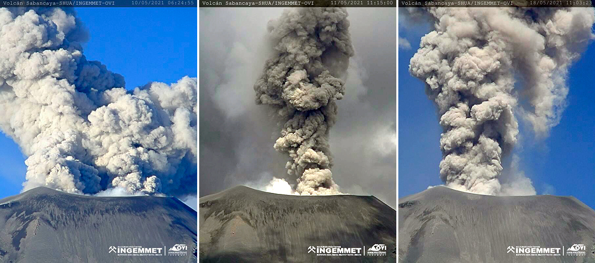 |
Figure 107. Daily ash emissions at Sabancaya during May 2021 rose from different areas within the summit crater. Two separate ash plumes on 10 May (left) originated from opposite sides of the crater, on 11 May (center) dense gray ash rose from the center right of the crater, and on 18 May it was rising from the left side of the crater (right). Courtesy of OVI-INGEMMET (Reporte de monitoreo volcanico RMVSAB-87, 88, and 93, on 10, 11, and 18 May 2021). |
Sentinel-2 satellite images showed thermal anomalies inside the summit crater on 3, 8, 13, 18, 23, and 28 June 2021. All were accompanied by ash emissions. Dense ash plumes rose up to 2,400 m above the summit from many of the 51-80 daily explosions (figure 108). The Buenos Aires VAAC also reported multiple plumes each day rising to 6.4-8.2 km altitude and drifting NE, E, or SE. Ashfall was reported in Achoma, Yanque, and Chivay during 2-4 June, and in Coporaque and Ichupampa on 3 June. Small amounts of ash were reported on 14 June in Chivay, Yanque, Ichupampa, and Coporaque, and on 30 June in Yanque, Achoma, Coporaque, Madrigal, and Cabanaconde.
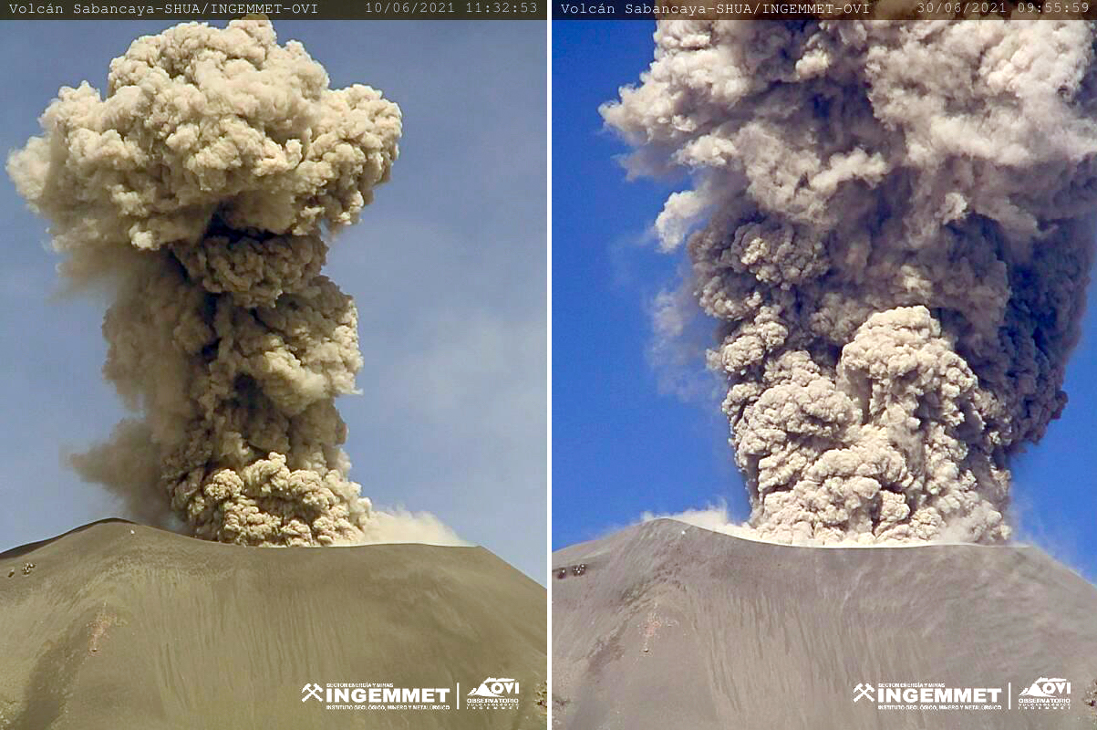 |
Figure 108. Dense ash emissions rose as high as 2,400 m above the summit crater at Sabancaya during June 2021, including the plumes on 10 (left) and 30 (right) June. Courtesy of OVI-INGEMMET (Reporte de monitoreo volcanico RMVSAB-110-2021 10 junio 2021, and RMVSAB-123-2021 30 junio 2021). |
Ashfall was reported in Cabanaconde on 1 July, in Huanca on 11, 22, and 23 July, and in Achoma on 16-17 July. Thermal anomalies, some with multiple distinct hotspots, were recorded in satellite images on 3, 8, 13, 18, 23, and 28 July. Plume heights ranged from 1,100-2,500 m above the summit from 47-118 daily explosions from several sites within the crater (figure 109); the Buenos Aires VAAC reported ash emissions drifting in many directions at 6.1-7.6 km altitude each day during the month.
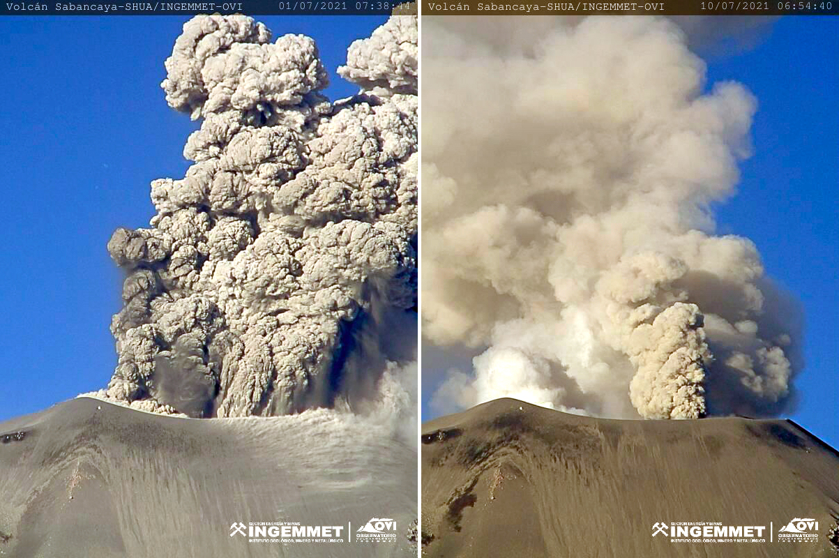 |
Figure 109. Ash and steam emissions from multiple sites on the growing dome at the summit crater of Sabancaya were typical throughout July 2021 including on 1 (left) and 10 (right) July. Courtesy of OVI-INGEMMET (Reporte de monitoreo volcanico RMVSAB-124-2021 and Reporte de actividad volcánica No. SAB189 2021, 10 de julio de 2021, 08:00 horas, Últimas 24 horas). |
The average number of daily explosions during August 2021 varied each week between 36 and 54, with plumes reported 2-3.5 km above the summit (figure 110). During the week of 9-15 August ash emissions were visible in satellite images drifting 134 km E and NE. The next week they appeared 68 km from the summit, and small amounts of ashfall were reported in Madrigal and Pinchollo. Satellite images showed thermal anomalies at the summit on 2, 12, 17, and 22 August. The Buenos Aires VAAC reported daily ash emissions rising to 6.7-8.2 km altitude. Similar activity continued throughout September 2021; ashfall was reported in Madrigal on 4 September. The number of daily explosions averaged 26-44 each week and plumes were reported 2-4 km above the summit. The Buenos Aires VAAC reported the daily ash emissions rising to 7.0-8.2 km altitude and drifting in multiple different directions. Satellite images showed thermal anomalies at the summit on 1, 11, and 16 September.
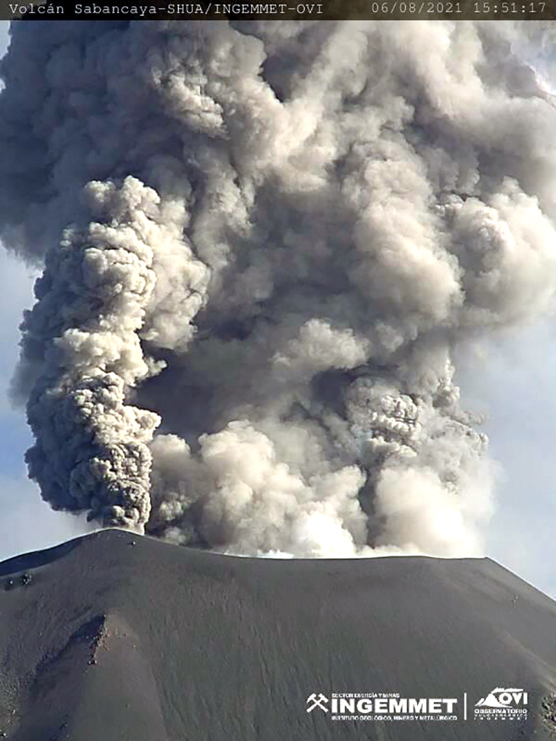 |
Figure 110. A dense ash plume from several source areas of the summit crater of Sabancaya rose multiple kilometers on 6 August 2021. Courtesy of OVI-INGEMMET (Reporte de monitoreo volcanico RMVSAB-123-2021, 2-8 agosto 2021). |
Geological Summary. Sabancaya, located in the saddle NE of Ampato and SE of Hualca Hualca volcanoes, is the youngest of these volcanic centers and the only one to have erupted in historical time. The oldest of the three, Nevado Hualca Hualca, is of probable late-Pliocene to early Pleistocene age. The name Sabancaya (meaning "tongue of fire" in the Quechua language) first appeared in records in 1595 CE, suggesting activity prior to that date. Holocene activity has consisted of Plinian eruptions followed by emission of voluminous andesitic and dacitic lava flows, which form an extensive apron around the volcano on all sides but the south. Records of observed eruptions date back to 1750 CE.
Information Contacts: Observatorio Volcanologico del INGEMMET (Instituto Geológical Minero y Metalúrgico), Barrio Magisterial Nro. 2 B-16 Umacollo - Yanahuara Arequipa, Peru (URL: http://ovi.ingemmet.gob.pe); Sentinel Hub Playground (URL: https://www.sentinel-hub.com/explore/sentinel-playground); NASA Global Sulfur Dioxide Monitoring Page, Atmospheric Chemistry and Dynamics Laboratory, NASA Goddard Space Flight Center (NASA/GSFC), 8800 Greenbelt Road, Goddard MD, USA (URL: https://so2.gsfc.nasa.gov/); MIROVA (Middle InfraRed Observation of Volcanic Activity), a collaborative project between the Universities of Turin and Florence (Italy) supported by the Centre for Volcanic Risk of the Italian Civil Protection Department (URL: http://www.mirovaweb.it/); Hawai'i Institute of Geophysics and Planetology (HIGP) - MODVOLC Thermal Alerts System, School of Ocean and Earth Science and Technology (SOEST), Univ. of Hawai'i, 2525 Correa Road, Honolulu, HI 96822, USA (URL: http://modis.higp.hawaii.edu/).