Report on Ol Doinyo Lengai (Tanzania) — November 2021

Bulletin of the Global Volcanism Network, vol. 46, no. 11 (November 2021)
Managing Editor: Edward Venzke.
Edited by Kadie L. Bennis.
Ol Doinyo Lengai (Tanzania) Ongoing crater activity with strong thermal anomalies during late August 2021
Please cite this report as:
Global Volcanism Program, 2021. Report on Ol Doinyo Lengai (Tanzania) (Bennis, K.L., and Venzke, E., eds.). Bulletin of the Global Volcanism Network, 46:11. Smithsonian Institution. https://doi.org/10.5479/si.GVP.BGVN202111-222120
Ol Doinyo Lengai
Tanzania
2.764°S, 35.914°E; summit elev. 2962 m
All times are local (unless otherwise noted)
Ol Doinyo Lengai, located near the southern end of the East African Rift in Tanzania, is known for its unique low-temperature carbonatitic lava. Activity primarily occurs in the crater offset to the N about 100 m below the summit where hornitos (small cones) and pit craters produce lava flows and spattering. Eruptions have been recorded since the late 19th century, while the current eruption has been ongoing since April 2017. Recent activity has been characterized by small lava flows in the summit crater (BGVN 46:04), which resumed during this reporting period of March through October 2021. Thermal activity increased notably during August 2021 and has been monitored using satellite data.
Activity was relatively low during March through July, but satellite views were often obscured by weather clouds. A single weak thermal anomaly was detected in the MIROVA graph during late June, which was also visible in Sentinel-2 infrared satellite imagery on the SW side of the crater. During July, the weak anomaly was in the center of the crater. Thermal activity increased in both frequency and strength by early August, which continued through early September (figure 213). The stronger anomalies filled a majority of the summit crater during late August, based on Sentinel-2 infrared satellite imagery, likely representing ongoing lava effusion originating from a central hornito (figure 214). By 20 September the thermal activity had decreased in power, though a weak lava flow had migrated from the center of the crater to the NE side. After September, the anomalies continued to be detected, but at a lower frequency and strength, and clouds often obscured views of the summit. According to the MODVOLC algorithm, a total of 24 thermal alerts were detected near the summit to the N of the summit: 23 were recorded on 7 October and one was recorded on 12 October.
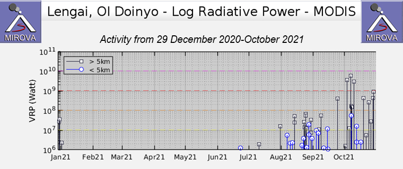 |
Figure 213. Low- to moderate-power thermal anomalies at Ol Doinyo Lengai were intermittent during August-October 2021, based on MODIS satellite data shown on this MIROVA graph (Log Radiative Power). Only a single weak anomaly was detected in late June. Courtesy of MIROVA. |
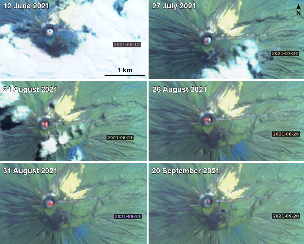 |
Figure 214. Sentinel-2 infrared imagery of Ol Doinyo Lengai from 12 June through 20 September 2021 showed thermal anomalies (bright yellow-orange) in the summit crater on clear weather days. On 12 June (top left), the anomaly was weak and located on the SW side of the crater. On 27 July (top right) it had migrated to the center of the crater. During three days in late August, the 21st (middle left), 26th (middle right), and 31st (bottom left), the thermal anomaly filled the N and NW sides of the crater. On 31 August a lava flow extended SE from the center of the crater. An image from 20 September (bottom right) showed a weaker anomaly in the center and NE side of the crater. Images use “Atmospheric penetration” rendering (bands 12, 11, 8A). Courtesy of Sentinel Hub Playground. |
Photos taken during a visit on 19 January 2021 showed active lava flows in the summit crater (figure 215). Other visitors took photos of the summit crater on 1 June 2021 that showed fresh lava flows along the crater floor (figure 216).
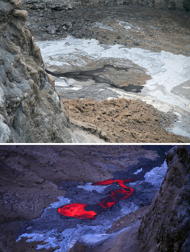 |
Figure 215. Photos of active lava flows (dark black and incandescent yellow-orange) in the summit crater of Ol Doinyo Lengai taken on 19 January 2021. Courtesy of Jeremey Riffault. |
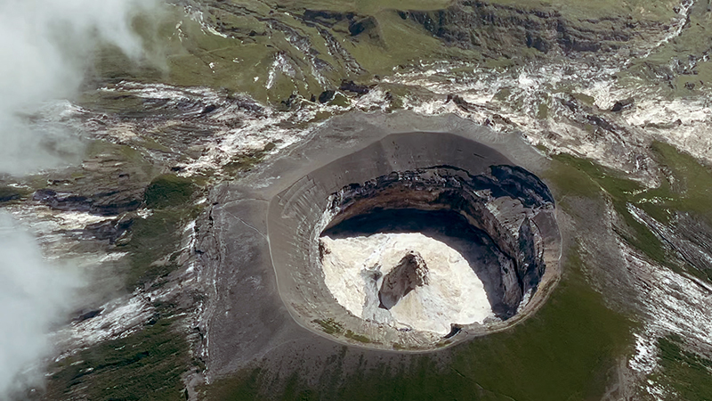 |
Figure 216. Photo of Ol Doinyo Lengai’s summit crater showing a fresh black lava flow originating from a central hornito on 1 June 2021. Courtesy of Jon Gianulias. |
Geological Summary. The symmetrical Ol Doinyo Lengai is the only volcano known to have erupted carbonatite tephras and lavas in historical time. The prominent stratovolcano, known to the Maasai as "The Mountain of God," rises abruptly above the broad plain south of Lake Natron in the Gregory Rift Valley. The cone-building stage ended about 15,000 years ago and was followed by periodic ejection of natrocarbonatitic and nephelinite tephra during the Holocene. Historical eruptions have consisted of smaller tephra ejections and emission of numerous natrocarbonatitic lava flows on the floor of the summit crater and occasionally down the upper flanks. The depth and morphology of the northern crater have changed dramatically during the course of historical eruptions, ranging from steep crater walls about 200 m deep in the mid-20th century to shallow platforms mostly filling the crater. Long-term lava effusion in the summit crater beginning in 1983 had by the turn of the century mostly filled the northern crater; by late 1998 lava had begun overflowing the crater rim.
Information Contacts: MIROVA (Middle InfraRed Observation of Volcanic Activity), a collaborative project between the Universities of Turin and Florence (Italy) supported by the Centre for Volcanic Risk of the Italian Civil Protection Department (URL: http://www.mirovaweb.it/); Hawai'i Institute of Geophysics and Planetology (HIGP) - MODVOLC Thermal Alerts System, School of Ocean and Earth Science and Technology (SOEST), Univ. of Hawai'i, 2525 Correa Road, Honolulu, HI 96822, USA (URL: http://modis.higp.hawaii.edu/); Sentinel Hub Playground (URL: https://www.sentinel-hub.com/explore/sentinel-playground); Jeremey Riffault (URL: https://twitter.com/JeremyRiffault); Jon Gianulias (URL: https://www.youtube.com/user/911JGian/featured).