Fukutoku-Oka-no-Ba
Japan
24.285°N, 141.481°E; summit elev. -29 m
All times are local (unless otherwise noted)
Fukutoku-Oka-no-ba is a submarine volcano located 5 km NE of the Japanese island of Minami-Ioto, about 1,300 km S of Tokyo. Typical activity at the site has consisted of discolored water and floating pumice. An island (called “Shin-Ioto”) was present during 1904-1905 and 1914. The 1986 eruption also built an island 600 m long and 15 m high which was later eroded away, according to information from the Japan Coast Guard. An explosion above the water surface was observed on 3 February 2010, which continued into that April (BGVN 41:06). Intermittent observations of discolored water have been made since that time, but there has been no notable eruptive activity until strong explosions in mid-August 2021 sent ash plumes to altitudes of over 12 km. Observations and monthly and special information reports come from the Japan Meteorological Agency (JMA), Japan Coast Guard (JCG) and Japan Maritime Self Defense Force (JMSDF), as well as various satellite data.
Summary of activity during May 2014-July 2021. Between May 2014 and 6 March 2016, the Japan Coast Guard intermittently visited the site, though no reports of water discoloration were made (table 4). Beginning on 7 March 2016, a pale green discoloration was noted in the water, measuring 200 x 1,000 m. Similar variations of greenish discolored water continued intermittently leading up to the eruption on 13 August 2021.
Table 4. Summary of observations made at Fukutoku-Oka-no-Ba between October 2015 and December 2021 by Japanese authorities. The Japan Coast Guard continued to visit the site intermittently, noting occasional water discoloration. Sources: JMA = Monthly Summary Report, Japan Meteorological Agency, JMSDF = Japan Maritime Self Defense Force, TRCGH = Third Regional Coast Guard Headquarters, JCG = Japan Coast Guard.
| Visit Date |
Discolored Water |
Dimensions |
Description |
Source |
| 11 Jun 2014 |
No |
-- |
-- |
MSDF |
| 13 Jun 2014 |
No |
-- |
-- |
TRCGH |
| 25 Jun 2014 |
No |
-- |
-- |
JCG |
| 12 Sep 2014 |
No |
-- |
-- |
MSDF |
| 26 Nov 2014 |
No |
-- |
-- |
TRCGH |
| 26 Dec 2014 |
No |
-- |
-- |
MSDF |
| 27 Jan 2015 |
No |
-- |
-- |
TRCGH |
| 15 Feb 2015 |
No |
-- |
-- |
TRCGH |
| 18 Feb 2015 |
No |
-- |
-- |
TRCGH |
| 14 Apr 2015 |
No |
-- |
-- |
TRCGH |
| 05 May 2015 |
No |
-- |
-- |
TRCGH |
| 26 May 2015 |
No |
-- |
-- |
TRCGH |
| 17 Aug 2015 |
No |
-- |
-- |
JCG |
| 23 Aug 2015 |
No |
-- |
-- |
TRCGH |
| 18 Oct 2015 |
No |
-- |
-- |
TRCGH |
| 07 Mar 2016 |
Yes |
200 x 1,000 m |
Very pale green |
TRCGH |
| 29 Mar 2016 |
No |
-- |
-- |
JCG |
| 24 Dec 2016 |
No |
-- |
-- |
JCG |
| 09 Feb 2017 |
No |
-- |
-- |
MSDF |
| 07 Mar 2017 |
Yes |
500 m radius |
Light green, four locations vent |
JMSDF |
| 24 Mar 2017 |
Yes |
50 x 1,000 m NE |
Yellow-green |
JCG |
| 30 Mar 2017 |
Yes |
700 m diameter |
Pale green |
MSDF |
| 24 Apr 2017 |
No |
-- |
-- |
MSDF |
| 28 Jun 2017 |
No |
-- |
-- |
JCG |
| 03 Jul 2017 |
No |
-- |
-- |
MSDF |
| 06 Oct 2017 |
No |
-- |
-- |
MSDF |
| 11 Dec 2017 |
Yes |
2 x 6 km |
Pale green |
JCG |
| 27 Jan 2018 |
Yes |
600 m diameter |
Yellow-green |
MSDF |
| 24 Feb 2018 |
Yes |
500 x 1,000 m |
Light green |
MSDF |
| 27 Apr 2018 |
No |
-- |
-- |
MSDF |
| 18 Jul 2018 |
No |
-- |
-- |
JCG |
| 29 Jan 2019 |
Yes |
1 km diameter |
Light green |
JCG |
| 19 Nov 2019 |
No |
-- |
-- |
JCG |
| 04 Feb 2020 |
Yes |
-- |
Whitish yellow-green drifting E |
JCG |
| 15 Mar 2020 |
Yes |
-- |
Bluish-white |
JCG |
| 16 Apr 2020 |
Yes |
-- |
Yellow-green |
TRCGH |
| 19 Apr 2020 |
Yes |
-- |
Bluish white drifting E |
TRCGH |
| 18 May 2020 |
No |
-- |
-- |
TRCGH |
| 19 Jun 2020 |
No |
-- |
-- |
JCG |
| 05 Apr 2021 |
Yes |
-- |
Pale blue |
JCG |
| 08 Jun 2021 |
Yes |
2.4 km diameter N |
Bluish-white |
JCG |
| 09 Jul 2021 |
Yes |
-- |
Bluish-white |
JCG |
| 05 Aug 2021 |
Yes |
-- |
Bluish-white drifted SSW |
JCG |
| 13 Aug 2021 |
-- |
-- |
Eruption began, though observations could not be made |
TRCGH |
| 15 Aug 2021 |
-- |
1 km diameter |
New island with intermittent eruptions and floating pumice drifting 60 km NW |
TRCGH |
| 16 Aug 2021 |
Yes |
-- |
Gas-and-steam plume from the island, suspended pumice drifted 100 km WNW |
JCG |
| 26 Aug 2021 |
Yes |
-- |
Brown drifting W, suspended pumice |
JCG |
| 12 Sep 2021 |
Yes |
2 km diameter |
Yellowish-green to yellowish-brown, second yellow-green discolored area 2 km ENE of the island |
JCG |
| 12 Oct 2021 |
Yes |
-- |
Brown and yellow-green drifting 5.6 km NW, white waves |
JCG |
| 01 Nov 2021 |
Yes |
-- |
Bluish-white |
TRCGH |
| 11 Nov 2021 |
Yes |
3 km diameter and 2 km diameter |
Dark yellow-green and a second yellow-green with floating pumice |
JCG |
| 29 Nov 2021 |
Yes |
-- |
Brown to yellowish-green |
TRCGH |
| 14 Dec 2021 |
Yes |
-- |
Yellow-green and bluish-white |
TRCGH |
| 27 Dec 2021 |
Yes |
-- |
Brown and yellowish-green |
JCG |
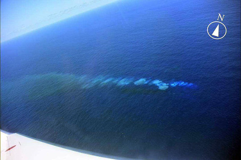
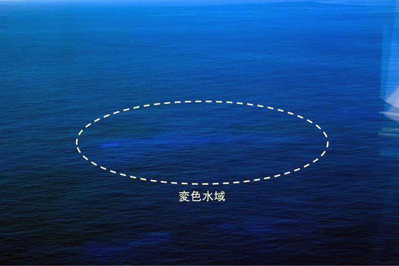
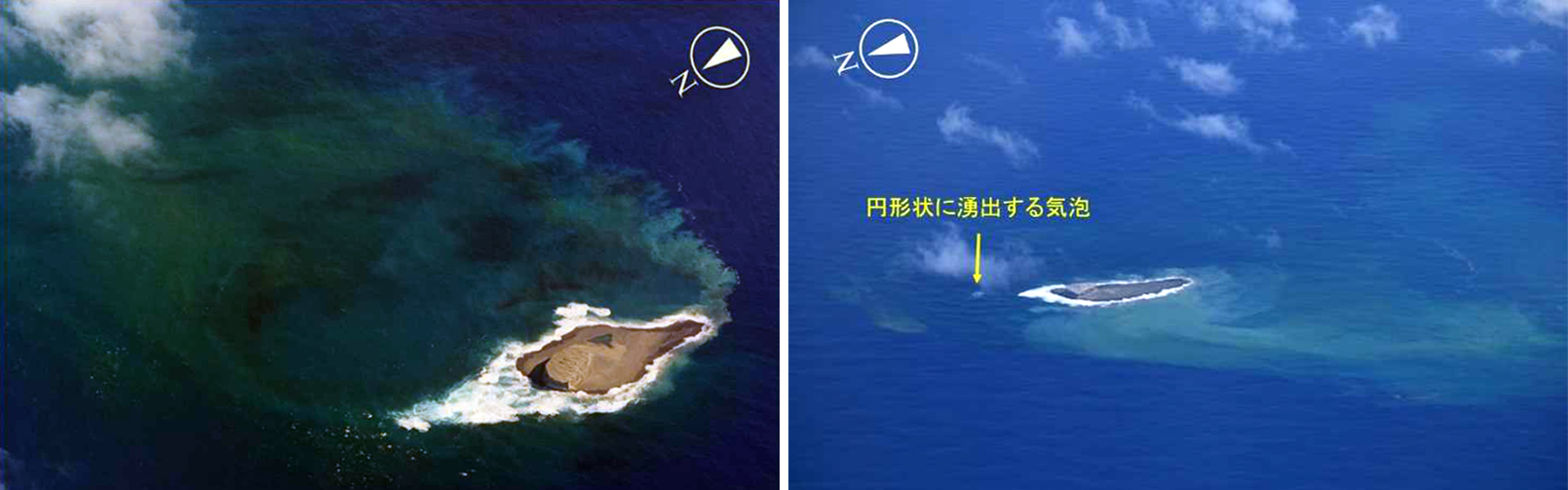
Observers on four overflights during 2020 reported visible discolored water originating from a single location, which has been frequently noted since 2005, according to JMA. On 4 February 2020 the Japan Coast Guard (JCG) conducted an overflight that confirmed pale white- to yellow-green discolored water on the ocean surface near the volcano over a distance of about 6.3 km to the W (figure 16). Discolored bluish-white water was again reported by JCG during an overflight on 15 March, though it was fainter than the previous observations. Similar faint discolored water was reported on 16 and 19 April by JCG. No further activity was reported for the rest of 2020. Similar activity was observed in overflights by JCG during the first half of 2021. Faintly discolored water (light blue to white) was observed during overflights on 5 April, 8 June, and 9 July (figure 17) according to JCG.
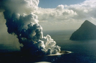
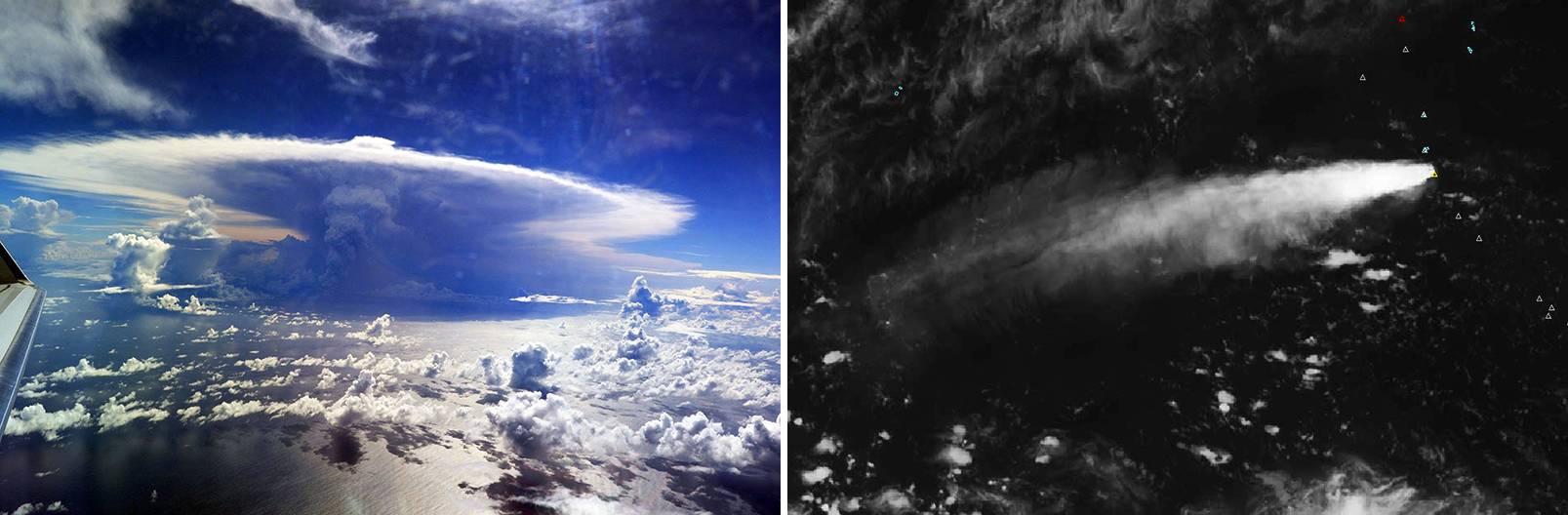
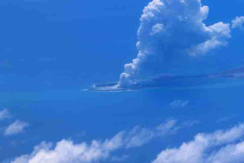
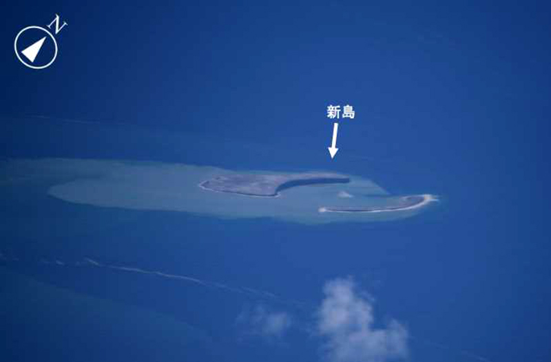
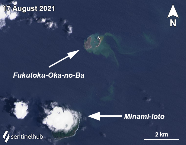
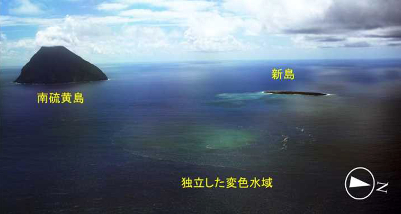
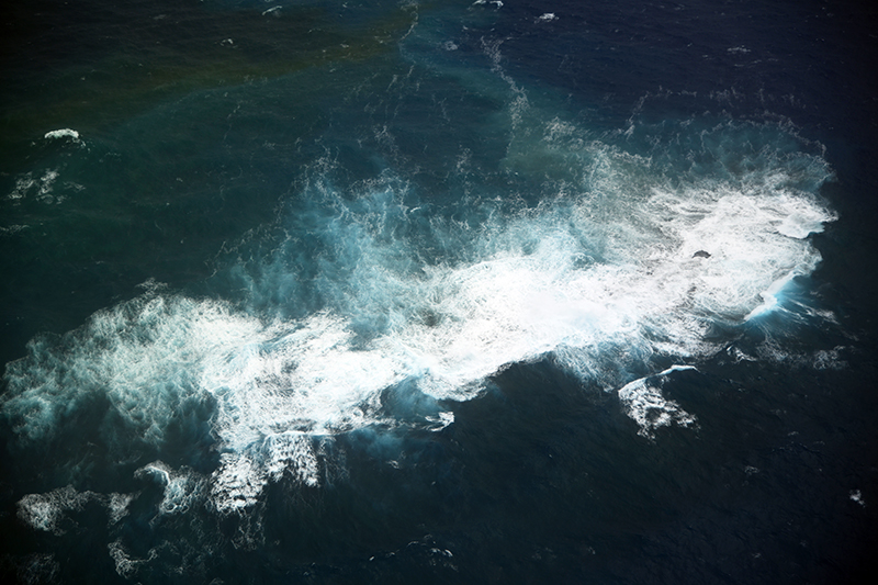
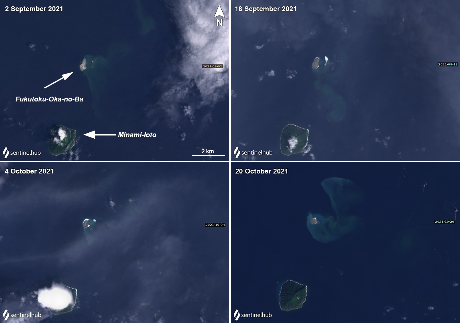
Eruption during August 2021. During aerial observations on 5 August the JCG only saw a blue-white discolored area SSW of the volcano. A large eruption starting at 0620 on 13 August 2021 was reported by JCG, based on satellite data, and was later confirmed during an overflight that day. The resulting ash plume rose as high as 16 km altitude and had drifted 700-1,000 km W by 0900 (figure 18). Video data showed Surtseyan explosions that ejected black material above the ocean surface and drifted W. Ash plumes identified in satellite images rose 12.2-16 km altitude during 13-15 August (figure 19) and eventually reached the N part of Luzon Island in the Philippines (2,000 km SW); the height decreased after the initial ejection, though activity continued. During an overflight on 15 August the JCG observed a new island (also referred to as “Niijima”) that measured about 1 km in diameter, where gas-and-steam emissions were detected rising from its center on 16 August (figure 20). Brown discoloration of a variable shape, but with a consistent diameter of 1 km, was visible surrounding the new island. Additionally, a notable floating pumice raft was photographed extending up to 60-100 km WNW and was about 13 km wide (figure 21). A Sentinel-2 natural color satellite image captured the newly formed island, surrounded by yellow-green discolored water that extended E the next day on 17 August (figure 22).
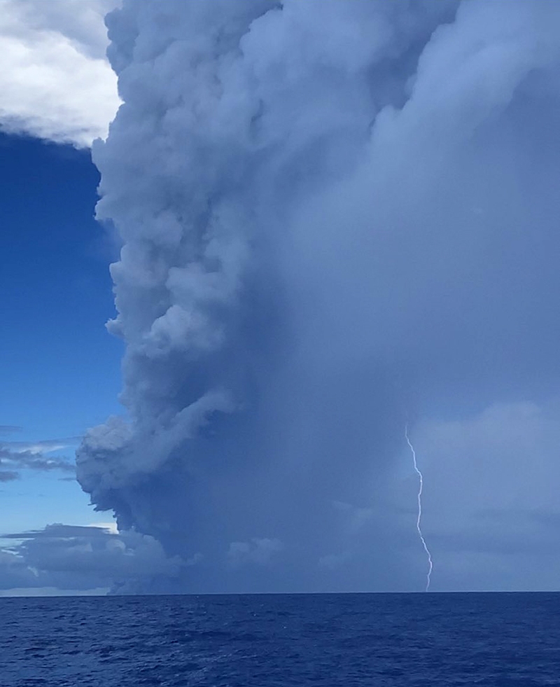
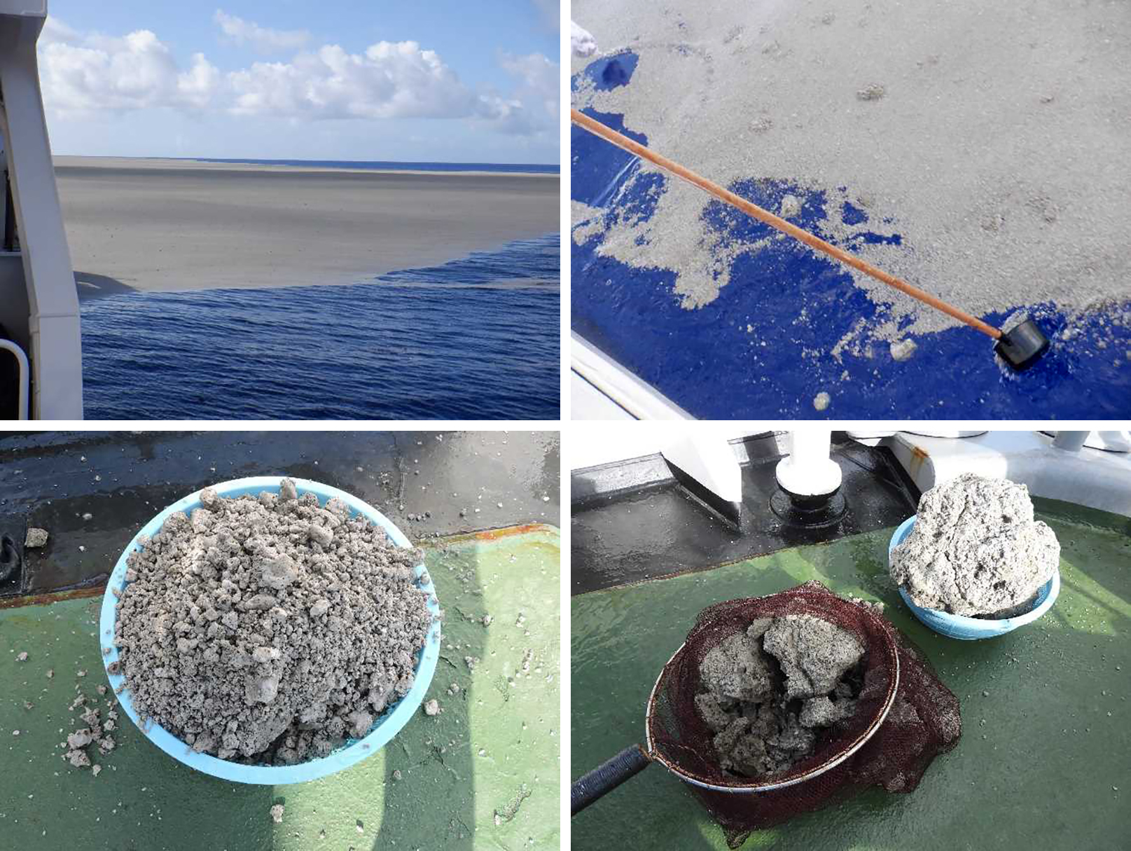
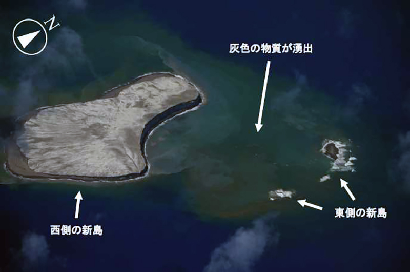
A local fisherman about 5 km SSW near South Iwo Jima (Minami-Ioto) posted photos from 17 (figure 23), 20, and 22 August showing a plume rising above the volcano. On 20 August lightning was visible within the plume. Another plume was observed during 0430-0630 on 22 August and some of the floating pumice was collected by the Ocean Meteorological Observation vessel, Keikaze Maru (figure 24). The largest sample was about 40 cm in diameter; samples were mainly white, gray, and dark gray with visible bubbles, which JMA reported was similar to the samples collected from the 1986 eruption. During an overflight on 26 August observers noted that while the W part of the island remained unchanged, the E side had mostly eroded, yielding two small islands (figure 25). Though no eruptive activity was visible, gray material from the central vent was intermittently ejected to the ocean surface, and brown discolored water remained widely distributed, extending especially to the W.
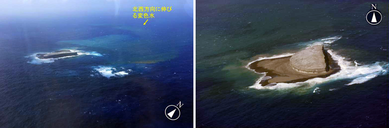
Activity during September-December 2021. JMA reported that the yellow-green to yellow-brown discolored water continued to be widely distributed in the area during September. By 12 September an overflight showed that the E side of the island had been completely eroded and submerged (figure 26), while the length of the W side measured 1 km. Yellow-green to yellow-brown discolored water extended from the vent area to the SW, S, and SE. In addition, on 12 September an area of yellow-green to yellow-brown discolored water 2 km in diameter, independent of the initial eruption site, was observed 2 km ENE of the new island (figure 27). Floating pumice were also noted around the discolored area. As a result, JMA issued a navigation warning to nearby vessels.
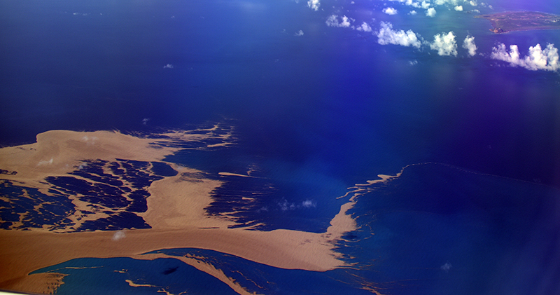
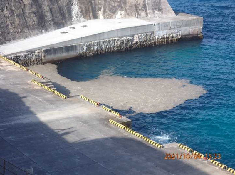
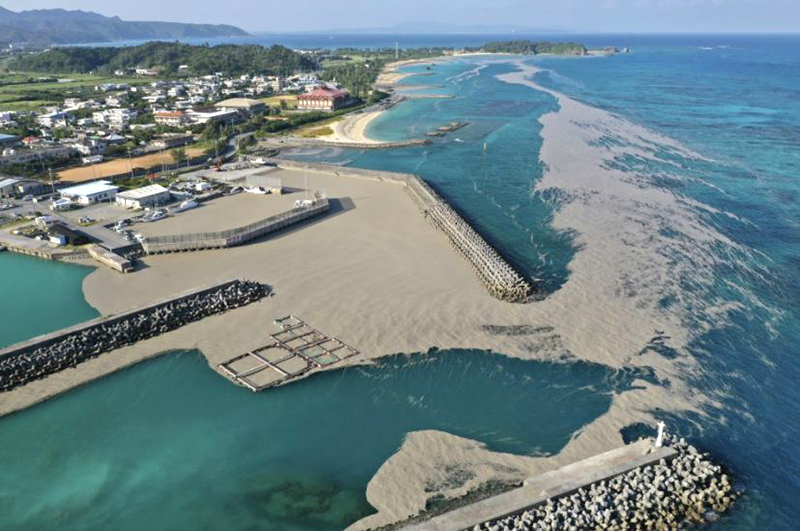
Discolored water areas persisted into October, as well as floating pumice. By early October the JCG reported that the floating pumice that was ejected during the eruption in mid-August had reached the coastlines more than 1,000 km from the volcano. Pumice first reached Minamidaitou Island (1,000 km W) on 4 October (figure 28) and samples were collected and compared to those collected on 22 August. Pumice was later reported at Kitadaito Island (1,000 km W) during 5-8 October. Aerial observations reported that the W side of the new island had eroded to a third of the size it was when previously described on 12 September (figure 29). Brownish discolored water was distributed near the N shore of the W part of the island, accompanied by yellow-green discoloration, extending about 6 km NW of the volcano (figure 29). Later in the month, the pumice circled Okinawa and Maejima islands (1,400 km W) and several ports in the Kagoshima prefecture (1,300 km NW), which damaged hundreds of boats and ships, clogged harbors (figure 30), and impacted the fishing and tourism industries in several areas, which led local governments to begin removing the pumice from the water.
During an overflight on 11 November white fumarolic plumes were observed rising from the N end of the island, accompanied by a blue-white band of discolored water in the S part of the island and a dark yellow-green band on the W side (figure 31). Circular discoloration was also observed on the N side of the island, along with bubbling that was seen on the ocean surface near the same location. On 27 December observers reported that the island that formed in mid-August had become smaller since 14 December and had almost eroded below the ocean surface. No eruptive activity was observed, though discolored brownish water was visible from the E end of the island. Yellow-green water and a 400-m-long string of floating pumice was circulating 5 km E of the volcano. Discolored water was visible surrounding almost the entire coast of Minami-Ioto (5 km SSW).
During December the brown-yellow discoloration continued to spread around the island, which by 27 December had noticeably decreased in size since seen on 29 November. Blue-white discoloration expanded to the NNE. Brown discolored water was visible from the E side of the island as yellow-green discoloration was distributed 5 km E of the same location. On 27 December the island was covered with white waves and was surrounded by blue-green discolored water (figure 32).
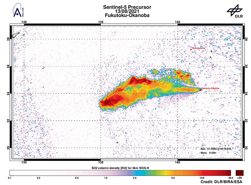
Satellite data. Landsat-8 satellite images were used to track the occurrence and direction of the discolored water plumes originating at the volcano (figure 33). Discoloration was detected during February 2021 and then reappeared after the start of the eruption in August. Accompanying the discolored water is the emergence of the new island that formed as a result of the eruption, which visibly decreased in size from August to October. A strong sulfur dioxide plume was captured in the Sentinel-5P satellite on 13 August 2021, drifting W as far as 350 km and rising to 3 km altitude (figure 34). The plume exceeded 18 DUs (Dobson Units).
Geological Summary. Fukutoku-Oka-no-ba is a submarine volcano located 5 km NE of the island of Minami-Ioto. Water discoloration is frequently observed, and several ephemeral islands have formed in the 20th century. The first of these formed Shin-Ioto ("New Sulfur Island") in 1904, and the most recent island was formed in 1986. The volcano is part of an elongated edifice with two major topographic highs trending NNW-SSE, and is a trachyandesitic volcano geochemically similar to Ioto.
Information Contacts: Japan Meteorological Agency (JMA), 1-3-4 Otemachi, Chiyoda-ku, Tokyo 100-8122, Japan (URL: http://www.jma.go.jp/jma/indexe.html); Japan Coast Guard (JCG) Volcano Database, Hydrographic and Oceanographic Department, 3-1-1, Kasumigaseki, Chiyoda-ku, Tokyo 100-8932, Japan (URL: http://www.kaiho.mlit.go.jp/info/kouhou/h29/index.html); NASA Global Sulfur Dioxide Monitoring Page, Atmospheric Chemistry and Dynamics Laboratory, NASA Goddard Space Flight Center (NASA/GSFC), 8800 Greenbelt Road, Goddard MD 20771, USA (URL: https://so2.gsfc.nasa.gov/); NHK Japan Broadcasting Corporation, 2-2-1 Jinnan, Shibuya-ku, Tokyo 150-8001, Japan (URL: https://www.nhk.or.jp/, https://twitter.com/nhk_news/media); Yukio Hayakawa, Gunma University, Japan, 371-8510 Gunma, Maebashi, Aramakimachi, 4-2 (URL: http://www.hayakawayukio.jp/, https://twitter.com/HayakawaYukio); Yutaka Kosugi (URL: https://twitter.com/yutaka_kosugi); German Aerospace Center (DLR), Linder Höhe, 51147 Koeln, Germany (URL: https://www.dlr.de/en); Royal Belgian Institute for Space Aeronomy (BIRA-IASB), Ringlaan 3, Avenue Circulaire 3, 1180 Brussels (URL: https://www.aeronomie.be/index.php/en); The European Space Agency (ESA), 24 rue du Général Bertrand, CS 30798, 75345 Paris CEDEX 7, France (URL: https://www.esa.int/).