Report on Pinatubo (Philippines) — December 2021

Bulletin of the Global Volcanism Network, vol. 46, no. 12 (December 2021)
Managing Editor: Edward Venzke.
Research and preparation by Paul Berger.
Pinatubo (Philippines) Phreatic explosion on 30 November 2021 sends steam plume above 13 km
Please cite this report as:
Global Volcanism Program, 2021. Report on Pinatubo (Philippines) (Venzke, E., ed.). Bulletin of the Global Volcanism Network, 46:12. Smithsonian Institution. https://doi.org/10.5479/si.GVP.BGVN202112-273083
Pinatubo
Philippines
15.13°N, 120.35°E; summit elev. 1486 m
All times are local (unless otherwise noted)
A phreatic explosion from the summit crater lake at Pinatubo in November 2021 is the first notable volcanic activity since 1992-93 when there was dome growth and secondary phreatic explosions in the aftermath of the major 1991 eruption. The volcano is monitored by the Philippine Institute of Volcanology and Seismology (PHIVOLCS), Tokyo Volcanic Ash Advisory Center (VAAC), and satellites.
The PHIVOLCS volcano update on 30 November 2021 reported that a weak phreatic explosion was recorded during 1209-1213 that day. Because of the very low seismicity and CO2 flux during the previous few days, they suggested that the event was triggered by shallow hydrothermal processes. A plume mostly comprised of steam rose above weather clouds (figure 40). The Tokyo VAAC reported that the plume reached an altitude of 13.4 km and drifted W based on satellite data; it was also observed by a passing aircraft (figure 41). Immediately after the explosion PHIVOLCS warned the public not to venture close to the volcano and advised local governments to prohibit entry into Pinatubo’s crater, as shallow phreatic or hydrothermal explosions could occur without warning.
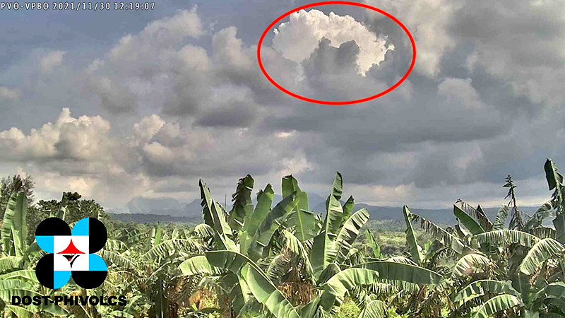 |
Figure 40. Image of 30 November 2021 plume taken 12 km NW of Pinatubo’s crater. The steam-dominated whitish top of the plume rose above the cloud cover over the volcano a few minutes after the explosion. Courtesy of PHIVOLCS via Twitter. |
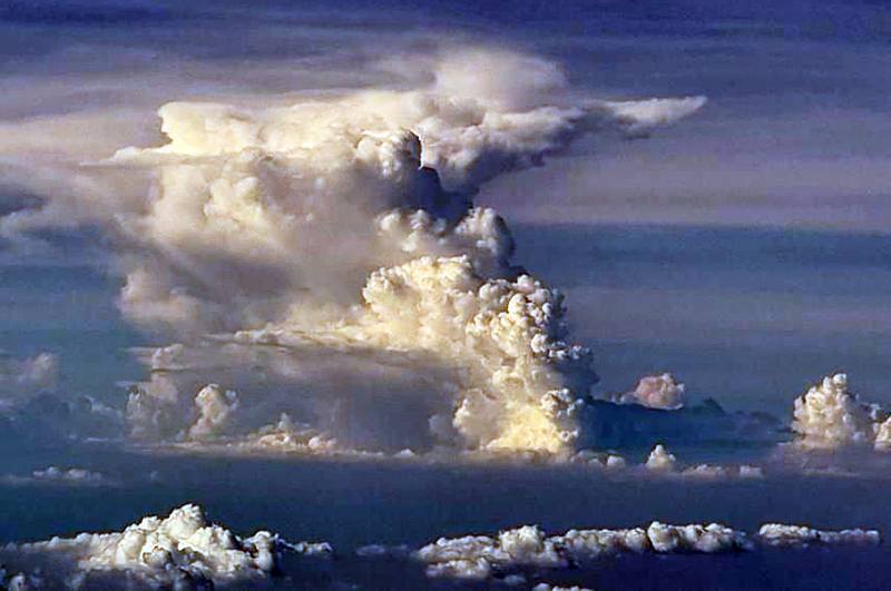 |
Figure 41. Aerial view of the 30 November 2021 explosion plume from Pinatubo. Photo by Capt. Aljess Lasmarias of Philippines AirAsia; courtesy of CNN Philippines. |
Numerous weak thermal anomalies were recorded by the MIROVA system around the time of the explosion. NASA recorded a high SO2 level above the volcano on 29-30 November, around the time of the explosion, with a plume drifting W and SW (figure 42).
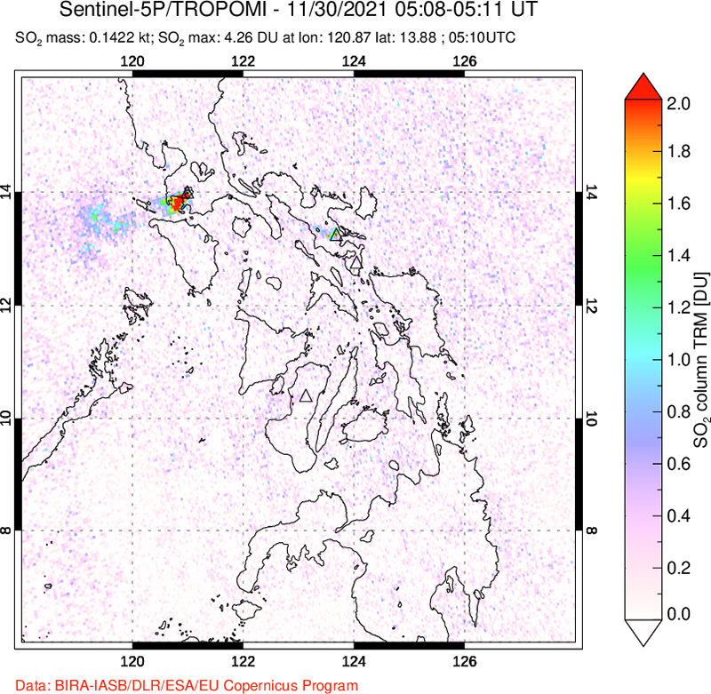 |
Figure 42. Satellite map showing a small SO2 plume drifting W and SW from Pinatubo on 30 November 2021, as detected by the TROPOMI instrument on the Copernicus Sentinel-5P satellite. Courtesy of NASA Global Sulfur Dioxide Monitoring Page. |
Geological Summary. Prior to 1991 Pinatubo volcano was a relatively unknown, heavily forested lava dome complex located 100 km NW of Manila with no records of historical eruptions. The 1991 eruption, one of the world's largest of the 20th century, ejected massive amounts of tephra and produced voluminous pyroclastic flows, forming a small, 2.5-km-wide summit caldera whose floor is now covered by a lake. Caldera formation lowered the height of the summit by more than 300 m. Although the eruption caused hundreds of fatalities and major damage with severe social and economic impact, successful monitoring efforts greatly reduced the number of fatalities. Widespread lahars that redistributed products of the 1991 eruption have continued to cause severe disruption. Previous major eruptive periods, interrupted by lengthy quiescent periods, have produced pyroclastic flows and lahars that were even more extensive than in 1991.
Information Contacts: Philippine Institute of Volcanology and Seismology (PHIVOLCS), Department of Science and Technology, University of the Philippines Campus, Diliman, Quezon City, Philippines (URL: http://www.phivolcs.dost.gov.ph/); Tokyo Volcanic Ash Advisory Center (VAAC), 1-3-4 Otemachi, Chiyoda-ku, Tokyo, Japan (URL: http://ds.data.jma.go.jp/svd/vaac/data/); MIROVA (Middle InfraRed Observation of Volcanic Activity), a collaborative project between the Universities of Turin and Florence (Italy) supported by the Centre for Volcanic Risk of the Italian Civil Protection Department (URL: http://www.mirovaweb.it/); NASA Global Sulfur Dioxide Monitoring Page, Atmospheric Chemistry and Dynamics Laboratory, NASA Goddard Space Flight Center (NASA/GSFC), 8800 Greenbelt Road, Goddard MD 20771, USA (URL: https://so2.gsfc.nasa.gov/); CNN Philippines (https://www.cnnphilippines.com/).