Report on Semisopochnoi (United States) — December 2021
Bulletin of the Global Volcanism Network, vol. 46, no. 12 (December 2021)
Managing Editor: Benjamin Andrews.
Edited by Kadie L. Bennis.
Semisopochnoi (United States) Intermittent explosions, ash plumes, and sulfur dioxide emissions during June-November 2021
Please cite this report as:
Global Volcanism Program, 2021. Report on Semisopochnoi (United States) (Bennis, K.L., and Andrews, B., eds.). Bulletin of the Global Volcanism Network, 46:12. Smithsonian Institution. https://doi.org/10.5479/si.GVP.BGVN202112-311060
Semisopochnoi
United States
51.93°N, 179.58°E; summit elev. 1221 m
All times are local (unless otherwise noted)
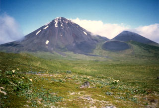
Semisopochnoi Island, located in the western Aleutian Islands, contains a group of cones within a caldera complex. The Cerberus center has three summit craters, with the current activity originating from North Cerberus Crater (see figure 5 in BGVN 46:06). Recent activity has consisted of intermittent small explosions and ash emissions since February 2021 (BGVN 46:06). This report describes continuing activity of explosions, ash plumes, and sulfur dioxide emissions during June through November 2021 using information primarily from the Alaska Volcano Observatory (AVO) and satellite data.
During the first half of June, AVO personnel reported low-level seismicity, in addition to minor gas-and-steam emissions (figure 14), elevated surface temperatures at the North Cerberus Crater, and low-level ash emissions that rose to 3 km altitude. Ash was also detected in GOES satellite data that showed several thin plumes that extended SW over Amchitka Island. As a result, minor ashfall occurred on the S part of Semisopochnoi Island, but there were no reports of it on Amchitka Island. By the second week of June, there was an overall decline in activity at the North Cerberus Crater; no eruptive activity was detected in infrasound or satellite data, or by AVO field crews; some sulfur dioxide emissions were observed in satellite data on 11 June. On 16 June AVO lowered the Aviation Color Code (ACC) and Volcano Alert Level (VAL) to Yellow and Advisory, respectively because no explosions or ash emissions had been detected since 30 May; seismicity remained relatively low.
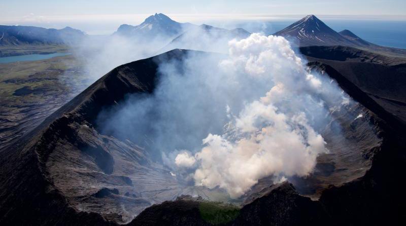 |
Figure 14. Photo of degassing at the North Cerberus Crater at Semisopochnoi on 8 June 2021. Photo by Cyrus Read, courtesy of AVO. |
An explosion that produced a small ash cloud rising to 1.5 km altitude was detected in local infrasound sensors and observed in satellite data at 1300 on 12 July, prompting AVO to raise the ACC and VAL to Orange and Watch, respectively. The event lasted about ten minutes. Following the explosion, seismicity declined and was characterized by intermittent and short bursts of tremor. Because of this marked decline in seismicity and no additional explosive events since 12 July, AVO lowered the ACC and VAL to Yellow and Advisory, respectively. Sulfur dioxide emissions were observed in satellite data on 17-19 and 24 July; the plume on 17 July drifted about 200 km N. Seismicity remained elevated during 23-27 July and robust gas-and-steam plumes were observed in webcam images on 22-24, 26, and 30 July (figure 15). A notable increase in activity at 0200 on 31 July prompted AVO to raise the ACC and VAL to Orange and Watch.
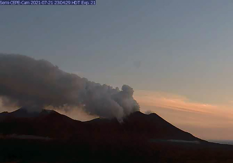 |
Figure 15. Webcam image from the CEPE station showing a gas-and-steam plume at Semisopochnoi during the evening on 21 July 2021. Courtesy of AVO. |
Multiple, discrete, and energetic explosions and increased seismicity were detected in August. The explosions ejected small ash clouds up to 3 km altitude and drifted as far as 160 km, according to AVO (figure 16). Ash emissions from the N crater were occasionally visible in webcam images and subsequent light ashfall was reported on the island. Sulfur dioxide emissions continued during the month. Local seismic networks recorded an explosion and an intense burst of seismic tremor that lasted for about 15 minutes at 1015 on 2 August. A small ash cloud was visible in satellite images and drifted 60 km N at an altitude of 1.5-3 km. An ash cloud generated at 2123 on 4 August was observed in satellite data until 0250 on 5 August, extending 180 km SE over Gareloi and S Tanaga Island. A small ash cloud at 2040 on 6 August drifted 50 km and another one at 2103 resulted in ashfall on the webcam 5 km NE. A large infrasound signal was recorded at 0653 on 8 August, although weather conditions prevented visual confirmation. At least three separate explosions were detected at 1714 on 8 August and 0339 and 0417 on 9 August; a small ash cloud rose to 900 m altitude on the morning of 9 August. During 9-10 August, ten explosions were observed in webcam images. According to the Anchorage VAAC, ash plumes rose to 3-3.9 km altitude during 14-16 and 27-29 August, based on GOES 17 and HIMAWARI satellite images. During 29-31 August ash drifted as far as 300 km NW.
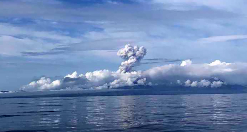 |
Figure 16. Photo of an eruption plume rising above Semisopochnoi on 3 August 2021. Photo by Nora Rojek, R/V Tiglax, courtesy of AVO. |
Explosions, ash plumes, elevated seismicity, and intermittent sulfur dioxide emissions continued during September; ash rose to 4.6 km altitude and local ashfall was visible in satellite data (figure 17). Short-lived daily explosions lasted several minutes, according to infrasound data. Sulfur dioxide emissions rose to altitudes no higher than 3 km and sometimes extended downwind for hundreds of kilometers. According to the Anchorage VAAC, ash plumes were detected to 3-4.6 km altitude on 6, 8, 21-23, 26 September. Overnight during 18-19 September small, discontinuous, low-level ash plumes were observed drifting 100 km SE. The frequency and intensity of the explosions increased during 19-20 September when an ash plume rose to 4.6 km altitude and extended as far as 330 km NW and 100 km SE, causing AVO to increase the ACC and VAL to Red and Warning, respectively. The frequency of discrete explosions decreased to a rate of one per hour on 20 September, resulting in lowering the ACC and VAL back to Orange and Watch, respectively; ash plumes continued to rise to 4.6 km altitude and drifted NW. Sulfur dioxide plumes drifted N during 20-21 September. Occasional low-level ash emissions drifted NW, W, and SE during 22-26 September.
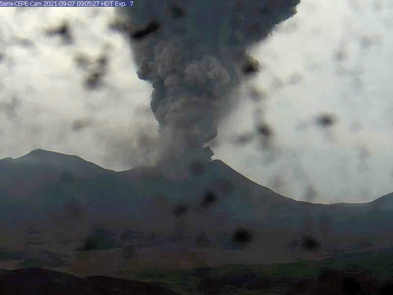 |
Figure 17. Webcam image from the CEPE station of the eruption plume at Semisopochnoi rising above the North Cerberus Crater on 7 September 2021. The black specks on the image are ashfall deposits. Courtesy of AVO. |
Similar activity including numerous explosions, ash emissions to less than 3 km altitude, elevated seismicity, and minor sulfur dioxide emissions in the N crater continued in October. Small ash clouds were observed in satellite imagery on 1, 2, and 3 October that rose to below 3 km altitude and dissipated 100 km from the volcano; the plumes drifted ENE on 2 October and N and NW on 3 October. On 3 October and 16 and 19 November an ash plume rose to 2.4-3 km altitude, based on information from the Anchorage VAAC. Webcams located 5-6 km from the Cerberus Crater recorded ashfall during 4-5 October. The plume on 19 October extended up to 250 km, though the direction was not defined, according to AVO. During 26, 27, and 29 October, ash plumes rose to 3.7 km altitude.
During November, activity in the N crater of Mount Cerberus persisted with minor explosions observed multiple times a day in geophysical and remote sensing data and low-level ash emissions that rose to 1.5-3.7 km altitude and extended 50-80 km based on webcam images and satellite observations (figure 18). Minor ashfall on the island was sometimes visible.
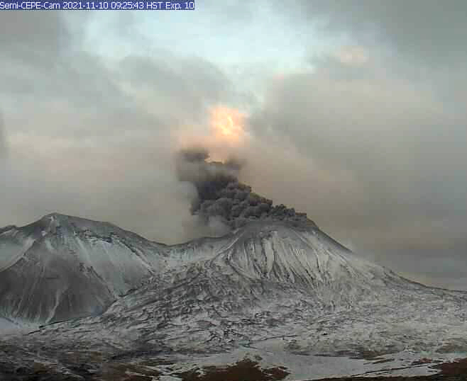 |
Figure 18. Webcam image from the CEPE station of low-level ash emissions rising from Semisopochnoi’s North Cerberus Crater on 10 November 2021. Courtesy of Matt Loewen, AVO. |
Sentinel-2 infrared satellite imagery showed a weak but persistent thermal anomaly in the North Cerberus Crater on clear weather days during June 2021, sometimes accompanied by gas-and-steam emissions (figure 19). Natural Color satellite imagery also showed gas-and-steam and ash plumes rising above the North Cerberus Crater throughout the reporting period, drifting in different directions (figure 20).
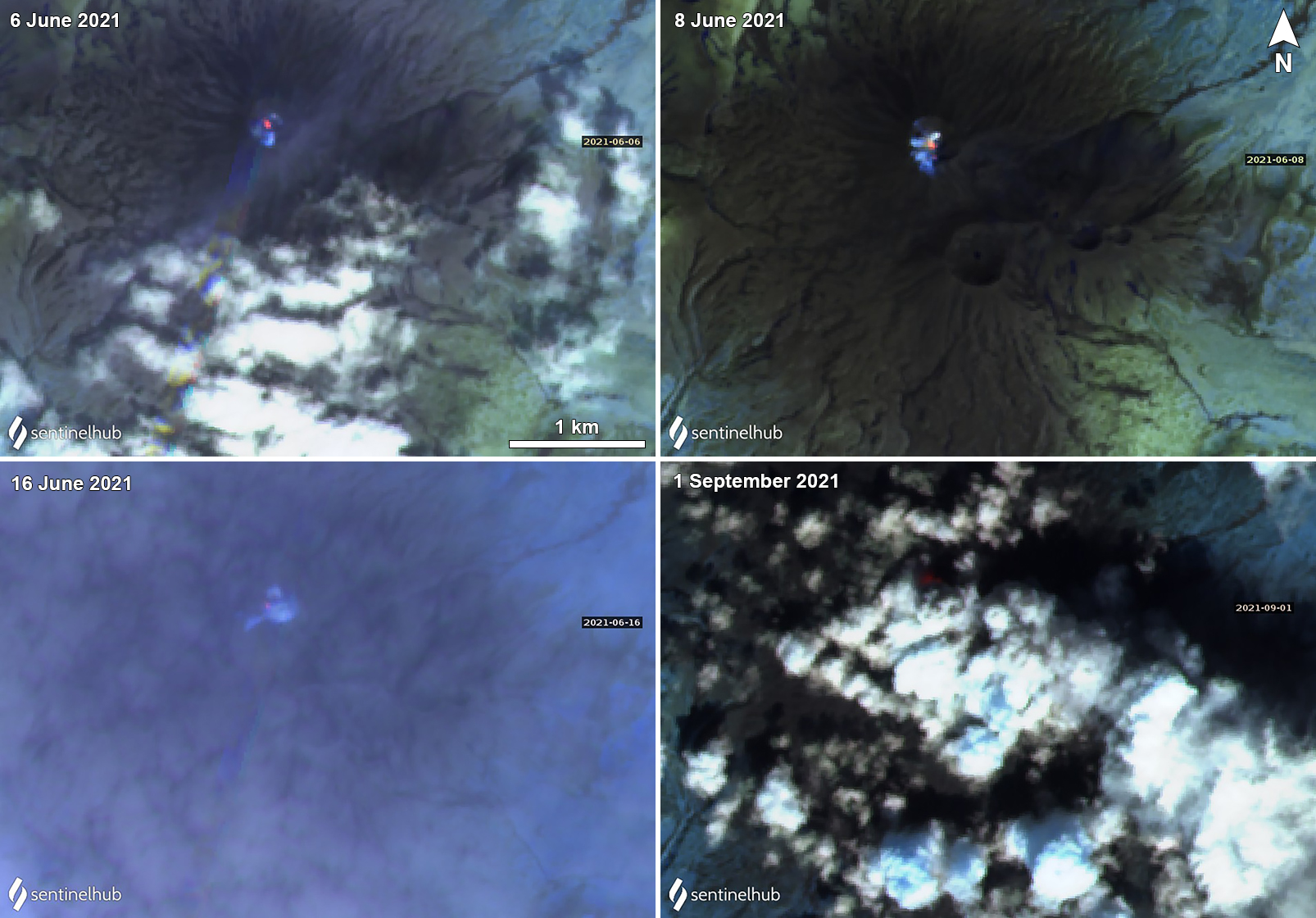 |
Figure 19. Sentinel-2 satellite images of a small thermal anomaly at Semisopochnoi during the first half of June on 6 June (top left), 8 June (top right), and 16 June (bottom left) 2021 that became progressively weaker; by 1 September (bottom right), clouds obscured most of the summit crater. Images using Sentinel-2 atmospheric penetration (bands 12, 11, 8A) images. Courtesy of Sentinel Hub Playground. |
 |
Figure 20. Gas-and-ash plumes are visible in Sentinel-2 satellite imagery from the Semisopochnoi North Cerberus Crater on 11 June (top left), 14 October (top right), 19 October (bottom left), and 18 November (bottom right) 2021 and drifting N and E. Sentinel-2 satellite images with Natural color (bands 4, 3, 2) rendering. Courtesy of Sentinel Hub Playground. |
Geological Summary. Semisopochnoi, the largest subaerial volcano of the western Aleutians, is 20 km wide at sea level and contains an 8-km-wide caldera. It formed as a result of collapse of a low-angle, dominantly basaltic volcano following the eruption of a large volume of dacitic pumice. The high point of the island is Anvil Peak, a double-peaked late-Pleistocene cone that forms much of the island's northern part. The three-peaked Mount Cerberus (renamed Mount Young in 2023) was constructed within the caldera during the Holocene. Each of the peaks contains a summit crater; lava flows on the N flank appear younger than those on the south side. Other post-caldera volcanoes include the symmetrical Sugarloaf Peak SSE of the caldera and Lakeshore Cone, a small cinder cone at the edge of Fenner Lake in the NE part of the caldera. Most documented eruptions have originated from Young, although Coats (1950) considered that both Sugarloaf and Lakeshore Cone could have been recently active.
Information Contacts: Alaska Volcano Observatory (AVO), a cooperative program of a) U.S. Geological Survey, 4200 University Drive, Anchorage, AK 99508-4667 USA (URL: https://avo.alaska.edu/), b) Geophysical Institute, University of Alaska, PO Box 757320, Fairbanks, AK 99775-7320, USA, and c) Alaska Division of Geological & Geophysical Surveys, 794 University Ave., Suite 200, Fairbanks, AK 99709, USA (URL: http://dggs.alaska.gov/); Anchorage Volcanic Ash Advisory Center (VAAC), Alaska Aviation Weather Unit, NWS NOAA US Dept of Commerce, 6930 Sand Lake Road, Anchorage, AK 99502-1845 USA (URL: http://vaac.arh.noaa.gov/); Sentinel Hub Playground (URL: https://www.sentinel-hub.com/explore/sentinel-playground).