Report on Pacaya (Guatemala) — December 2021

Bulletin of the Global Volcanism Network, vol. 46, no. 12 (December 2021)
Managing Editor: Edward Venzke.
Edited by A. Elizabeth Crafford.
Pacaya (Guatemala) Lava flow activity ceases mid-May 2021; last ash explosion reported on 13 August 2021
Please cite this report as:
Global Volcanism Program, 2021. Report on Pacaya (Guatemala) (Crafford, A.E., and Venzke, E., eds.). Bulletin of the Global Volcanism Network, 46:12. Smithsonian Institution. https://doi.org/10.5479/si.GVP.BGVN202112-342110
Pacaya
Guatemala
14.382°N, 90.601°W; summit elev. 2569 m
All times are local (unless otherwise noted)
Extensive lava flows, bomb-laden Strombolian explosions, and ash plumes from Mackenney crater have characterized persistent activity at Pacaya since 1961. The latest eruptive period began with intermittent ash plumes and incandescence in June 2015; the growth of a new pyroclastic cone inside the summit crater was confirmed later that year and continued, producing frequent loud Strombolian explosions and ash emissions through May 2021. In addition, flank fissures were the source of multiple kilometer-long lava flows during 2019-2021. A significant increase in both effusive and explosive activity that began in February 2021 continued through mid-May, decreased later that month, and was followed by minor ash emissions in June and August 2021. Activity during June-November 2021 is covered in this report with information provided primarily by Guatemala's Instituto Nacional de Sismologia, Vulcanologia, Meteorologia e Hydrologia (INSIVUMEH).
The last lava flow from the major eruptive events of 2020 and 2021 had begun on 29 April and grown to over 2 km long before activity at the fissure ceased on 17 May (figure 185, BGVN 46:06). Periodic ash emissions continued for the remainder of May, with the last reported ashfall on 26 May. Although no further significant eruptive activity was reported in terms of flows, incandescent ejecta, or ashfall from plumes, minor ash emission events were reported over the next few months. The MIROVA radiative power data for the period of January-November 2021 shows the high to very high levels of heat flow during the period of multiple active flows from January through mid-May, with an abrupt decline in energy after that. Cooling flows were the likely source of low levels of heat during July (figure 186).
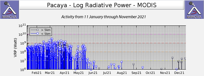 |
Figure 186. High levels of thermal energy at Pacaya were measured from January to mid-May 2021 from the multiple lava flows that emerged from fissures on the flanks of Mackenney crater. Flow activity ceased by mid-May, with cooling of the flows producing a low-level heat signature through the end of July. Courtesy of MIROVA. |
Sporadic ashfall was reported around Mackenney crater on 8 June 2021. The Washington VAAC reported a possible ash emission on 11 June drifting SW 35 km from the summit at 3 km altitude. No ash emissions, flows, or incandescent ejecta were reported during July. INSIVUMEH issued a Special Bulletin on 4 August reporting on three moderate explosions that produced ash plumes that rose to 3.5 km altitude and drifted N about 12 km; ashfall was reported in Mesías Altas, Mesías Bajas, and Villa Canales. The large pyroclastic cone that had nearly filled the inside of Mackenney crater was largely destroyed and had its own crater nearly the width of the cone about 100 m deep when viewed by researchers from the University of Bristol at the end of July (figure 187). Two explosions on 13 August produced ash plumes that drifted 1 km S.
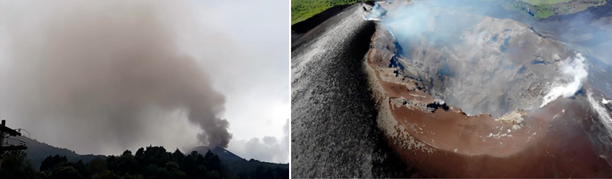 |
Figure 187. Activity near the end of the 2015-2021 eruption at Pacaya included three explosions on 4 August 2021 (left) that produced an ash plume that drifted N and produced ashfall about 10 km from the summit. In late July researchers from the University of Bristol observed the summit of Pacaya and noted the 100-m-deep crater inside the pyroclastic cone that filled Mackenney crater (right). Courtesy of INSIVUMEH (BOLETÍN VULCANOLÓGICO ESPECIAL BEPAC-103-2021, ACTUALIZACIÓN DE ACTIVIDAD VOLCÁN PACAYA, agosto 4, 2021, 06:15 pm hora local). |
Though INSIVUMEH noted the presence of ash in emissions on 14 September 2021, there was no significant plume or ashfall. For the remainder of October and November 2021 steam and gas emissions rose 150-400 m above the crater rim and drifted up to 1.5 km S or SW; there were no further reports of ash, ejecta, lava flows, or incandescence from Mackenney crater. A comparison of Sentinel 2 satellite images from February 2020 and November 2021 shows the extent of some of the new lava flows produced during the heightened activity of that period (figure 188).
 |
Figure 188. Lava from flow activity, primarily during February-May 2021 covers an area on the NW flank of Pacaya in the Sentinel-2 satellite image from 10 November 2021 (right); it is missing in the February 2020 image (left). Images use Atmospheric penetration rendering with bands 12, 11, and 8a. Courtesy of Sentinel Hub Playground. |
Geological Summary. Eruptions from Pacaya are frequently visible from Guatemala City, the nation's capital. This complex basaltic volcano was constructed just outside the southern topographic rim of the 14 x 16 km Pleistocene Amatitlán caldera. A cluster of dacitic lava domes occupies the southern caldera floor. The post-caldera Pacaya massif includes the older Pacaya Viejo and Cerro Grande stratovolcanoes and the currently active Mackenney stratovolcano. Collapse of Pacaya Viejo between 600 and 1,500 years ago produced a debris-avalanche deposit that extends 25 km onto the Pacific coastal plain and left an arcuate scarp inside which the modern Pacaya volcano (Mackenney cone) grew. The NW-flank Cerro Chino crater was last active in the 19th century. During the past several decades, activity has consisted of frequent Strombolian eruptions with intermittent lava flow extrusion that has partially filled in the caldera moat and covered the flanks of Mackenney cone, punctuated by occasional larger explosive eruptions that partially destroy the summit.
Information Contacts: Instituto Nacional de Sismologia, Vulcanologia, Meteorologia e Hydrologia (INSIVUMEH), Unit of Volcanology, Geologic Department of Investigation and Services, 7a Av. 14-57, Zona 13, Guatemala City, Guatemala (URL: http://www.insivumeh.gob.gt/ ); MIROVA (Middle InfraRed Observation of Volcanic Activity), a collaborative project between the Universities of Turin and Florence (Italy) supported by the Centre for Volcanic Risk of the Italian Civil Protection Department (URL: http://www.mirovaweb.it/); Sentinel Hub Playground (URL: https://www.sentinel-hub.com/explore/sentinel-playground).