Report on Krakatau (Indonesia) — January 2022

Bulletin of the Global Volcanism Network, vol. 47, no. 1 (January 2022)
Managing Editor: Edward Venzke.
Edited by Kadie L. Bennis.
Krakatau (Indonesia) Ash plumes and thermal anomalies during May 2021-November 2021
Please cite this report as:
Global Volcanism Program, 2022. Report on Krakatau (Indonesia) (Bennis, K.L., and Venzke, E., eds.). Bulletin of the Global Volcanism Network, 47:1. Smithsonian Institution. https://doi.org/10.5479/si.GVP.BGVN202201-262000
Krakatau
Indonesia
6.1009°S, 105.4233°E; summit elev. 285 m
All times are local (unless otherwise noted)
Krakatau is located in the Sunda Strait between Indonesia’s Java and Sumatra Islands and experienced a major caldera collapse around 535 CE, forming a 7-km-wide caldera ringed by three islands called Verlaten, Lang, and Rakata. The active Anak Krakatau (Child of Krakatau) cone was constructed within the 1883 caldera and has been the site of frequent eruptions since 1927. On 22 December 2018 a large explosion and flank collapse destroyed most of the 338-m-high island, generating a deadly tsunami (BGVN 44:03). The most recent eruption began in June 2018 and ended in April 2020, though intermittent thermal anomalies continued to be detected, accompanied by occasional diffuse white gas-and-steam emissions (BGVN 45:10). This report covers activity during October 2020 through December 2021; a new eruption that began on 25 May 2021 and was characterized by ash plumes and thermal anomalies, according to information from the Indonesian Center for Volcanology and Geological Hazard Mitigation, also known as Pusat Vulkanologi dan Mitigasi Bencana Geologi (PVMBG), the Darwin Volcanic Ash Advisory Centre (VAAC), and satellite data.
Non-eruptive activity was relatively low during October 2020 through April 2021; occasional white gas-and-steam emissions were visible in the CCTV Lava 93 webcam and Sentinel-2 natural color satellite imagery rising 20-200 m above the crater (figure 115), accompanied by volcanic tremors. Weak but distinct sulfur dioxide emissions were also detected in Sentinel-5P/TROPOMI maps, some of which reached 2 DUs (Dobson Units) (figure 116). On 25 May the Darwin VAAC reported a diffuse ash plume that rose to 1.8 km altitude and drifted SW, based on satellite images. Ash plumes were also reported on 2 and 7 July by the Darwin VAAC, rising to 1.5 km altitude and drifted SW and NW, respectively.
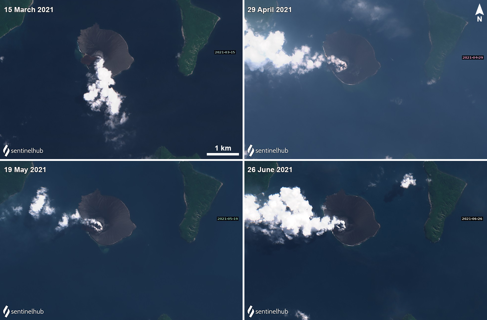 |
Figure 115. Sentinel-2 satellite imagery showed strong, intermittent white gas-and-steam plumes that drifted in different directions on 15 March (top left), 29 April (top right), 19 May (bottom left), and 26 June (bottom right) 2021. Images with “Natural color” rendering (bands 4, 3, 2). Courtesy of Sentinel Hub Playground. |
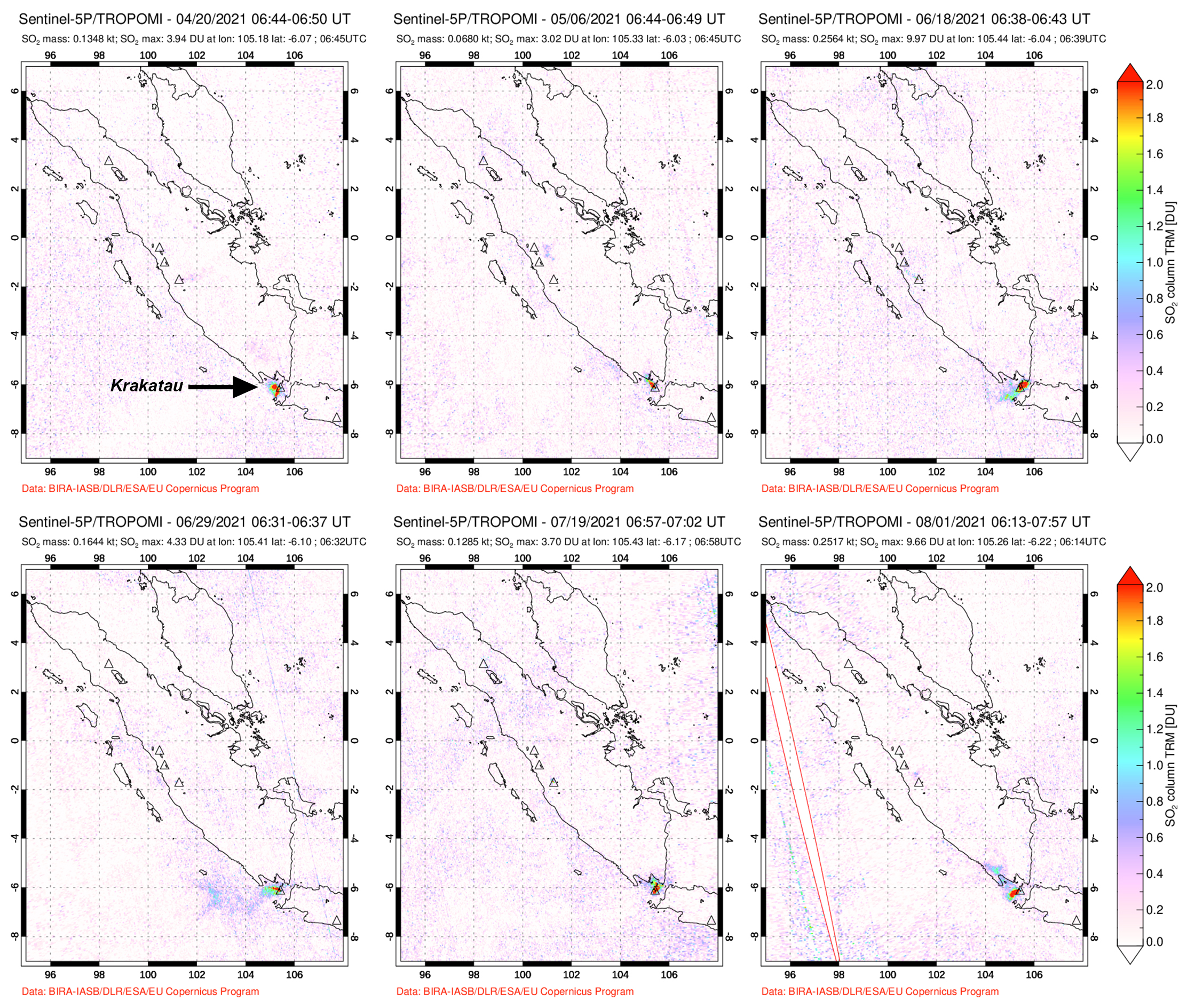 |
Figure 116. Weak but distinct sulfur dioxide emissions were detected above Krakatau based on data from the TROPOMI instrument on the Sentinel-5P satellite on 20 April (top left), 6 May (top middle), 18 June (top right), 29 June (bottom left), 19 July (bottom middle), and 1 August (bottom right) 2021. Courtesy of NASA Global Sulfur Dioxide Monitoring Page. |
Activity during July through October was dominantly intermittent white gas-and-steam emissions and volcanic tremors. PVMBG reported that at 1413 on 26 October an explosion that lasted 45 seconds (based on seismic data) produced a dense gray ash plume that rose 500 m above the summit and drifted N. White gas-and-steam emissions continued, rising 25-100 m above the summit. Visual data from the CCTV webcam during 6-7 November showed white to gray emissions rising as high as 100-150 m above the summit and crater incandescence three times, according to PVMBG.
The MIROVA (Middle InfraRed Observation of Volcanic Activity) graph of MODIS thermal anomaly data showed intermittent low- to moderate-power hotspots throughout 2021 with the exception of November (figure 117). During clear weather days, these thermal anomalies were also visible in the crater in Sentinel-2 infrared satellite imagery, sometimes accompanied by gas-and-steam emissions (figure 118).
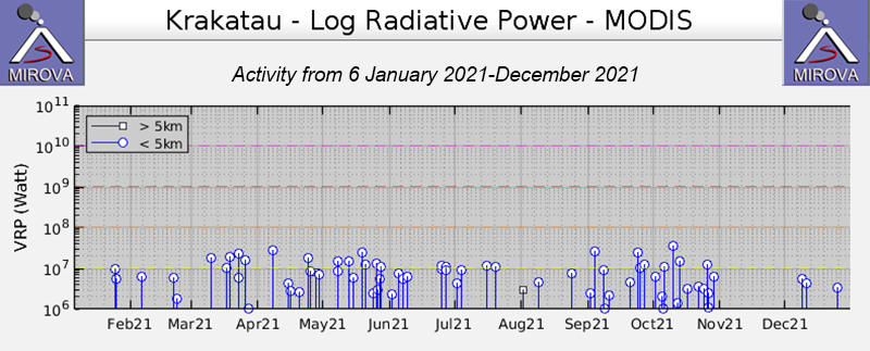 |
Figure 117. Intermittent thermal activity at Anak Krakatau from 6 January 2021 through December 2021 was moderate in power, as seen in this MIROVA Log Radiative Power graph, though no anomalies were detected during November. Courtesy of MIROVA. |
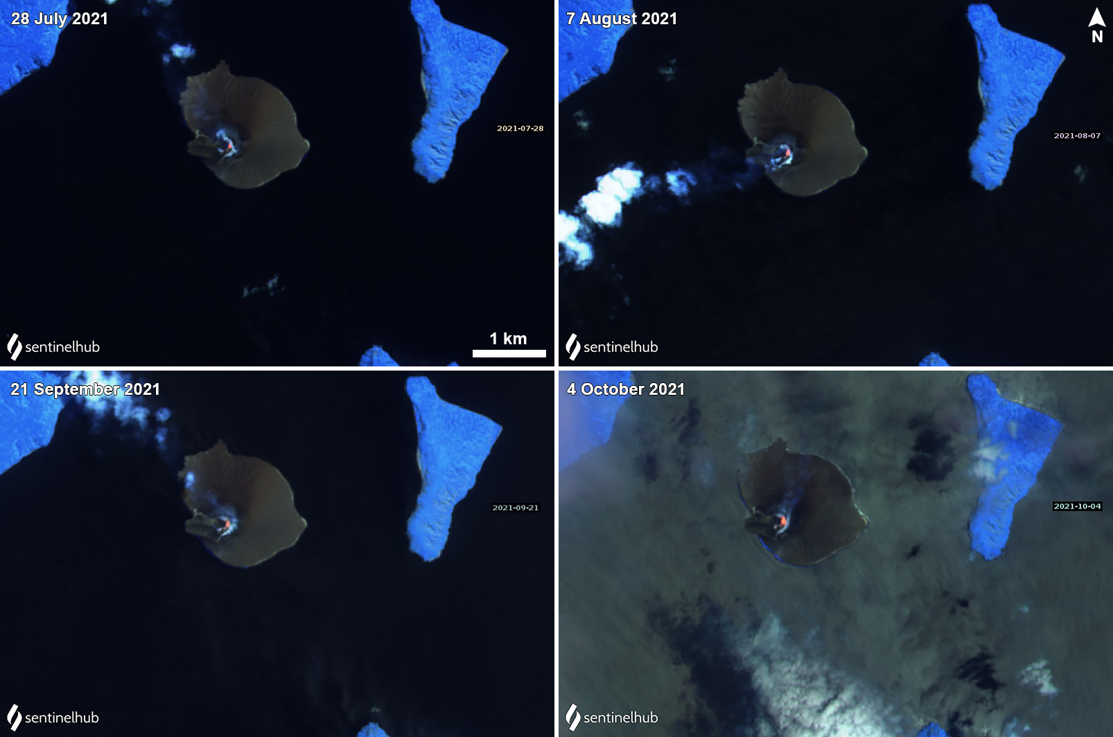 |
Figure 118. Sentinel-2 infrared satellite images showed a small thermal anomaly in the crater during 28 July (top left), 7 August (top right), 21 September (bottom left), and 4 October (bottom right). Occasional white gas-and-steam emissions accompanied these anomalies. Sentinel-2 satellite images with “Atmospheric penetration” (bands 12, 11, 8A) rendering. Courtesy of Sentinel Hub Playground. |
Geological Summary. The renowned Krakatau (frequently mis-named as Krakatoa) volcano lies in the Sunda Strait between Java and Sumatra. Collapse of an older edifice, perhaps in 416 or 535 CE, formed a 7-km-wide caldera. Remnants of that volcano are preserved in Verlaten and Lang Islands; subsequently the Rakata, Danan, and Perbuwatan cones were formed, coalescing to create the pre-1883 Krakatau Island. Caldera collapse during the catastrophic 1883 eruption destroyed Danan and Perbuwatan, and left only a remnant of Rakata. This eruption caused more than 36,000 fatalities, most as a result of tsunamis that swept the adjacent coastlines of Sumatra and Java. Pyroclastic surges traveled 40 km across the Sunda Strait and reached the Sumatra coast. After a quiescence of less than a half century, the post-collapse cone of Anak Krakatau (Child of Krakatau) was constructed within the 1883 caldera at a point between the former Danan and Perbuwatan cones. Anak Krakatau has been the site of frequent eruptions since 1927.
Information Contacts: Pusat Vulkanologi dan Mitigasi Bencana Geologi (PVMBG, also known as Indonesian Center for Volcanology and Geological Hazard Mitigation, CVGHM), Jalan Diponegoro 57, Bandung 40122, Indonesia (URL: http://www.vsi.esdm.go.id/); Darwin Volcanic Ash Advisory Centre (VAAC), Bureau of Meteorology, Northern Territory Regional Office, PO Box 40050, Casuarina, NT 0811, Australia (URL: http://www.bom.gov.au/info/vaac/); MIROVA (Middle InfraRed Observation of Volcanic Activity), a collaborative project between the Universities of Turin and Florence (Italy) supported by the Centre for Volcanic Risk of the Italian Civil Protection Department (URL: http://www.mirovaweb.it/); Sentinel Hub Playground (URL: https://www.sentinel-hub.com/explore/sentinel-playground).