Report on Aira (Japan) — January 2022

Bulletin of the Global Volcanism Network, vol. 47, no. 1 (January 2022)
Managing Editor: Edward Venzke.
Edited by A. Elizabeth Crafford.
Aira (Japan) Minor ash emissions July-December 2021
Please cite this report as:
Global Volcanism Program, 2022. Report on Aira (Japan) (Crafford, A.E., and Venzke, E., eds.). Bulletin of the Global Volcanism Network, 47:1. Smithsonian Institution. https://doi.org/10.5479/si.GVP.BGVN202201-282080
Aira
Japan
31.5772°N, 130.6589°E; summit elev. 1117 m
All times are local (unless otherwise noted)
Sakurajima rises from Kagoshima Bay, which fills the Aira Caldera near the southern tip of Japan's Kyushu Island. Frequent explosive and occasional effusive activity has been ongoing for centuries. The Minamidake summit cone and crater has been the location of persistent activity since 1955; the Showa crater on its E flank has also been intermittently active since 2006. Explosions and ash-bearing emissions have continued primarily at the Minamidake crater since the latest eruptive episode began in late March 2017. This report covers ongoing activity at Minamidake from July through December 2021; the Japan Meteorological Agency (JMA) provides monthly reports on activity, and the Tokyo VAAC (Volcanic Ash Advisory Center) issues information about the ash emissions.
Activity decreased significantly during the second half of 2021 beginning in May (BGVN 46:08). The number of monthly explosions and ash emissions were both much lower compared with the first half of the year (table 26), as was the amount of ashfall recorded around the volcano. Thermal energy remained at low levels throughout the period (figure 121) although incandescence was visible from the webcams at night when the weather was clear. Very few ash emissions were reported each month, and ash plumes never rose more than 1,300 m above the summit (figure 122). All of the activity originated from the Minamidaki crater; there were no reports of activity from the Showa crater.
Table 26. Number of monthly explosive events, ash emission events, days of ashfall, ashfall amounts, and sulfur dioxide emissions from Sakurajima’s Minamidake crater at Aira during July-December 2021. Note that smaller ash events are not listed. Ashfall days were measured at Kagoshima Local Meteorological Observatory, and ashfall amounts represent material covering all of the Kagoshima Prefecture. Data courtesy of JMA monthly reports.
| Month | Explosive events | Ash emission events | Days of ashfall | Ashfall amount (g/m2) | SO2 emissions (tons/day) |
| Jul 2021 | 0 | 1 | 6 | 1 | 800-1,000 |
| Aug 2021 | 0 | 0 | 0 | 0 | 600-1,500 |
| Sep 2021 | 0 | 4 | 5 | 3 | 700-2,600 |
| Oct 2021 | 1 | 1 | 5 | Less than 0.5 | 400-1,000 |
| Nov 2021 | 0 | 4 | 5 | Less than 0.5 | 700-1,200 |
| Dec 2021 | 0 | 7 | 2 | Less than 0.5 | 600-1,200 |
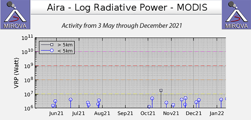 |
Figure 121. Thermal energy remained very low at Sakurajima in the Aira caldera throughout the second half of 2021 according to the MIROVA graph of Log Radiative Power from 3 May through December 2021. Courtesy of MIROVA. |
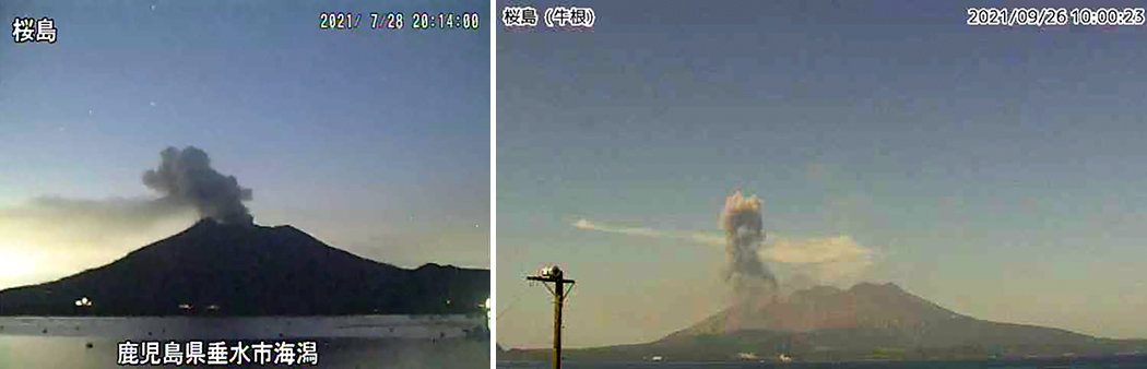 |
Figure 122. Few ash emissions were observed at Aira’s Sakurajima volcano during July-December 2021, and the ash plume heights never exceeded 1,300 m above the crater rim. The ash emission from the Minamidake summit crater on 28 July 2021 (left) rose 1,300 m above the crater rim as seen from the Kaigata surveillance camera. The ash plume on 26 September 2021 (right) rose to 1,100 m above the crater rim. Courtesy of JMA monthly reports. |
There were 61 volcanic earthquakes reported during July, up from 18 in June. Less than a minute of volcanic tremors were recorded during the month, a significant drop from the 22 minutes in June. At the Kagoshima Local Meteorological Observatory, located in Higashikorimoto about 11 km WSW of Minamidake, the total amount of ashfall measured during the six days it was recorded was 1 g/m2. The total ashfall for Kagoshima Prefecture during July was about 10,000 tons. JMA reported 800-1,000 tons/day of SO2 emissions in July. An explosion on 28 July produced an ash plume that rose 1,300 m above the crater rim; no large volcanic bombs were reported. The Tokyo VAAC reported the ash emission on 28 July as rising to 2.4 km altitude and drifting NW. Two small ash emissions occurred at Minamidake on 2 and 10 August 2021. The ash plume on 10 August rose 900 m above the crater rim. 143 volcanic earthquakes were recorded during the month with 5 minutes of volcanic tremor. No ashfall was reported at the Observatory and the total ashfall around the Prefecture for August was about 5,000 tons. JMA reported 600-1,500 tons/day SO2 emissions during August.
During September 2021 four significant ash emissions events occurred at Minamidake crater and a few very small events, but no larger explosions. On 19 September the Tokyo VAAC reported an ash emission that rose to 2.1 km altitude and remained stationary. The tallest ash plume, on 26 September, rose 1,100 m above the crater rim. Seismometers recorded 124 volcanic earthquakes and three minutes of volcanic tremor. JMA reported 700-2,600 tons/day SO2 emissions, increasing somewhat at the end of the month. Inclinometers and extensometers recorded slight inflation of the volcano beginning on 13 September after a long period with little change. At the Observatory, ashfall was reported on five days with a total amount measured of 3 g/m2. The September total ash mass for the Prefecture was estimated at around 10,000 tons.
One explosion occurred from Minamidake crater on 8 October 2021 that sent volcanic bombs 600-900 m from the crater, the largest event of the period. Clouds prevented visual observations during the explosion. Other smaller ash emission events were also recorded. There were 51 volcanic earthquakes and no tremors recorded during the month. Incandescence from the summit crater was visible throughout the month (figure 123). Sulfur dioxide emissions ranged from 400-1,000 tons/day; they increased temporarily during the second half of September. Inflation of the volcano that was measured from the GNSS observations beginning in mid-September slowed in the beginning of October and ceased by mid-month. Ashfall was recorded at the Observatory on five days during the month with a total amount of 0.5 g/m2 measured. The total ashfall in the Kagoshima Prefecture for October was estimated at 7,000 tons. No particular changes were observed at the Minamidake and Showa craters during an overflight on 18 October 2021. On 31 October the Tokyo VAAC reported an ash emission that rose to about 2.4 km altitude. Clear Sentinel images from 3 and 28 October showed a moderate thermal anomaly at vent “A” in Minamidake crater.
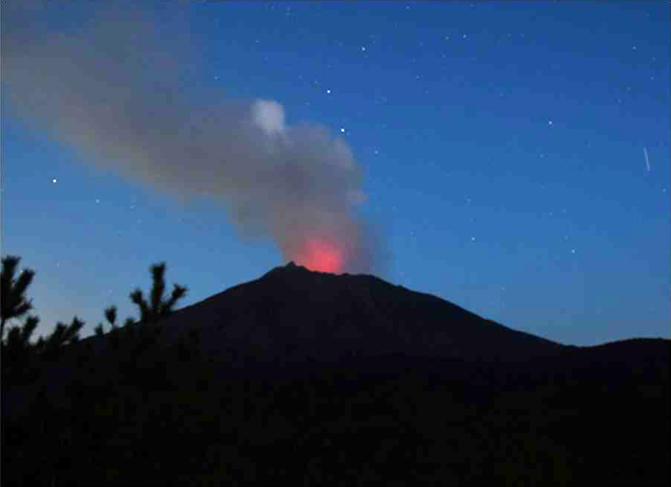 |
Figure 123. Incandescence was visible from the Minamidake summit crater at Sakurajima in the Aira caldera on 14 October 2021, and on most clear nights throughout the period. Courtesy of JMA Annual Report for 2021. |
Four recorded ash emission events were recorded by JMA at Minamidake crater during November 2021, and a few other much smaller events, but no large explosions took place. Ash emissions rose to a maximum height of 1,300 m above the crater rim. On 2 November the Tokyo VAAC reported an ash emission that rose to 2.4 km altitude and drifted SW. On 18 November two ash emissions also rose to 2.4 km altitude; one drifted SE and the other drifted NE. Observers on an overflight on 20 November saw no notable changes at the craters or surrounding summit area. An ash emission on 25 November rose to 2.1 km altitude and drifted E. Seismometers detected 57 volcanic earthquakes and no tremors during the month. Field measurements of SO2 indicated 700-1,200 tons/day were released by the volcano. Inclinometers and extensometers showed inflation during November. Ashfall total measured at the Observatory was less than 0.5 g/m2 over five days. The estimate of total ashfall in the prefecture for November was 5,000 tons. Clear skies on 2, 7, and 27 November revealed a thermal anomaly inside the Minamidake crater. In addition, a second faint thermal anomaly was visible inside the Minamidake crater on 27 November at vent ‘B’ (figure 124).
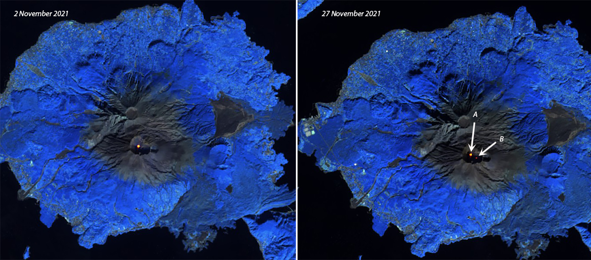 |
Figure 124. Clear skies on 2 (left) and 27 (right) November 2021 revealed thermal anomalies within the Minamidake crater at Aira’s Sakurajima volcano. The brighter anomaly in both images is from vent A, and the fainter anomaly is vent B. Sentinel 2 satellite images use Atmospheric penetration rendering (bands 12, 11, and 8a). Courtesy of Sentinel Hub Playground. |
During December 2021 larger ash emission events occurred seven times, an increase from previous months, and a few smaller events were also noted. The tallest ash plume rose 1,300 m above the crater rim on 2 December; the Tokyo VAAC reported the emission at 2.4 km altitude drifting SE. During an overflight on 8 December, no specific changes were visible at the summit crater area (figure 125). On 9 December an ash plume rose to 2.1 km altitude and drifted E. The next day two emissions rose to 2.4 km; one drifted NE. On 20 December an ash emission rose to 2.1 km altitude and drifted E. On 21 and 28 December ash plumes rose to 2.4 km and extended SE and E. Seismometers measured 136 volcanic earthquakes and less than one minute of tremor that was associated with very small ash emission events. Field measurements indicated 600-1,200 tons of SO2 were released daily. Inflation of the volcano decreased during December. Only slight ashfall (less than 0.5 g/m3) was recorded on two days of the month at the Observatory. A single thermal anomaly was visible inside the crater in Sentinel satellite imagery on 7 December, but an ash emission was visible on 22 December (figure 126).
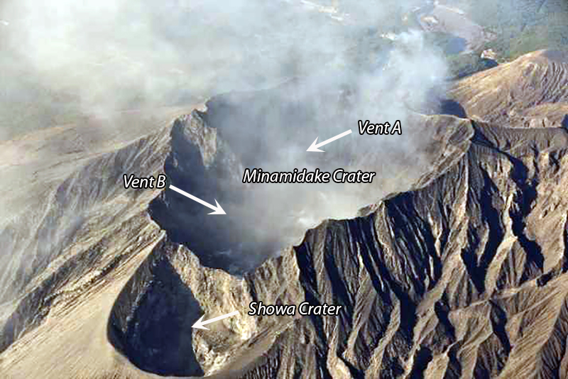 |
Figure 125. The Minimidake and Showa craters at the summit of Sakurajima in the Aira caldera seen in this aerial photo. Two active vents, A and B, are within the Minamidake crater. Image taken during an overflight on 8 December 2021. Courtesy of JMA Monthly Report. |
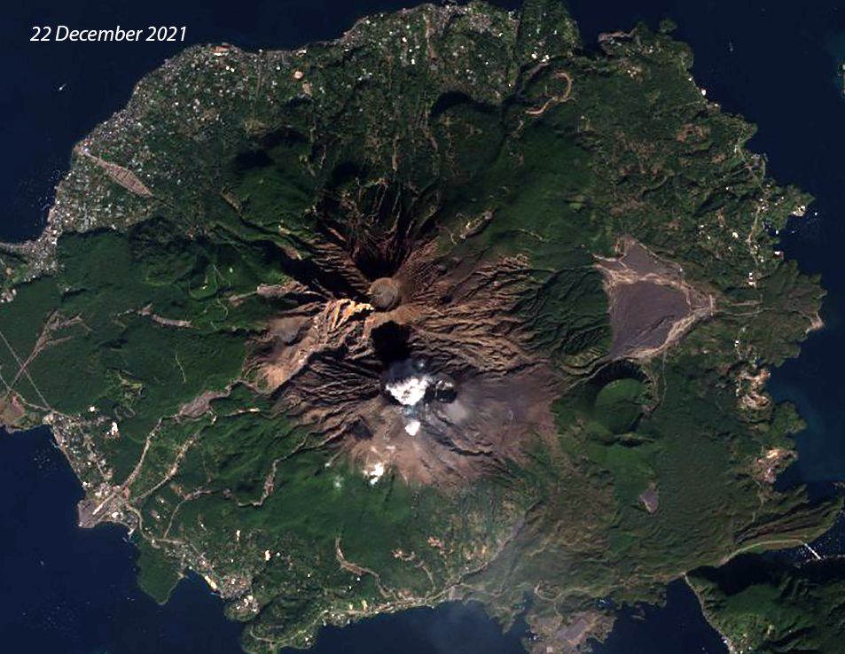 |
Figure 126. An ash emission rose from the Minamidake crater at Aira caldera’s Sakurajima volcano on 22 December 2021 and was recorded by this Natural color rendering (bands 4, 3, 2) Sentinel 2 satellite image. Courtesy of Sentinel Hub Playground. |
Geological Summary. The Aira caldera in the northern half of Kagoshima Bay contains the post-caldera Sakurajima volcano, one of Japan's most active. Eruption of the voluminous Ito pyroclastic flow accompanied formation of the 17 x 23 km caldera about 22,000 years ago. The smaller Wakamiko caldera was formed during the early Holocene in the NE corner of the caldera, along with several post-caldera cones. The construction of Sakurajima began about 13,000 years ago on the southern rim and built an island that was joined to the Osumi Peninsula during the major explosive and effusive eruption of 1914. Activity at the Kitadake summit cone ended about 4,850 years ago, after which eruptions took place at Minamidake. Frequent eruptions since the 8th century have deposited ash on the city of Kagoshima, located across Kagoshima Bay only 8 km from the summit. The largest recorded eruption took place during 1471-76.
Information Contacts: Japan Meteorological Agency (JMA), 1-3-4 Otemachi, Chiyoda-ku, Tokyo 100-8122, Japan (URL: http://www.jma.go.jp/jma/indexe.html); MIROVA (Middle InfraRed Observation of Volcanic Activity), a collaborative project between the Universities of Turin and Florence (Italy) supported by the Centre for Volcanic Risk of the Italian Civil Protection Department (URL: http://www.mirovaweb.it/); Sentinel Hub Playground (URL: https://www.sentinel-hub.com/explore/sentinel-playground).