Report on Sarychev Peak (Russia) — January 2022
Bulletin of the Global Volcanism Network, vol. 47, no. 1 (January 2022)
Managing Editor: Edward Venzke.
Edited by Kadie L. Bennis.
Sarychev Peak (Russia) Few ash emissions and thermal anomalies during February-December 2021
Please cite this report as:
Global Volcanism Program, 2022. Report on Sarychev Peak (Russia) (Bennis, K.L., and Venzke, E., eds.). Bulletin of the Global Volcanism Network, 47:1. Smithsonian Institution. https://doi.org/10.5479/si.GVP.BGVN202201-290240
Sarychev Peak
Russia
48.092°N, 153.2°E; summit elev. 1496 m
All times are local (unless otherwise noted)
Sarychev Peak occupies the NW end of Matua Island in the Kuril Islands with a central cone that was constructed in a 3-3.5 km caldera with a rim that is exposed on the SW side. Reported eruptions date back to the 1760s, characterized by both lava effusions and strong explosions. Larger eruptions in 1946 and 2009 produced pyroclastic flows that reached the sea. Its current eruption period began during February 2020 and has consisted of an ash eruption, lava flows, and ashfall deposits (BGVN 46:05). This report covers activity during February through December 2021 based on reports from the Sakhalin Volcanic Eruption Response Team (SVERT), the Kamchatka Volcanic Eruptions Response Team (KVERT), and the Tokyo Volcanic Ash Advisory Center.
During a majority of February, a lava flow continued to effuse onto the N slope of the volcano. According to satellite data, a thermal anomaly was observed in the summit on 1 February, though clouds often obscured it. Moderate gas-and-steam emissions were also reported. KVERT reported that on 19 February the effusive eruption had ended, though lava continued to advance in the summit crater and a thermal anomaly remained visible.
SVERT reported that on 12, 23, 25, and 29 June thermal anomalies were detected. The Tokyo VAAC issued a notice on 29 June and 1 July reporting brief ash emissions that rose to 3-3.4 km altitude and drifted W, SE, and E, based on satellite images. At 0020 on 30 June an ash plume was visible in satellite data that rose to 3 km altitude and drifted 30 km WNW. Plumes drifted as far as 25 km E on 1 July.
The MIROVA (Middle InfraRed Observation of Volcanic Activity) volcano hotspot detection system based on the analysis of MODIS data showed intermittent low-power thermal anomalies from late May through mid-November (figure 43). Two stronger anomalies were detected during early June and early July, the latter of which was also detected by the MODVOLC thermal algorithm on 1 July. This thermal activity was also detected in Sentinel-2 infrared satellite imagery, showing a clear thermal anomaly in the summit crater during February through September (figure 44). Though the thermal anomalies became less frequent and strong after August, MIROVA detected five anomalies during October and one weak anomaly in mid-November. Sentinel-2 also showed a weak anomaly on 9 and 26 November, the former of which also revealed trace ash deposits on the E flank and the latter of which was accompanied by a small ash plume that drifted N.
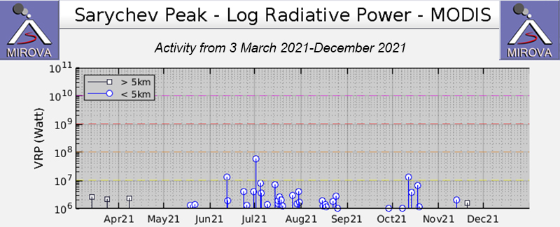 |
Figure 43. Intermittent low-power thermal anomalies at Sarychev Peak were detected by the MIROVA system (Log Radiative Power) beginning in late May through mid-November 2021. Two stronger anomalies were detected during early June and early July. A notable break in thermal activity occurred during a majority of September. Courtesy of MIROVA. |
 |
Figure 44. Sentinel-2 infrared satellite images showing a consistent thermal anomaly in the summit crater of Sarychev Peak on 14 February (top left), 19 March (top right), 5 May (middle left), 29 June (middle right), 7 July (bottom left), and 17 September (bottom right) 2021. Images using “Atmospheric penetration” rendering (bands 12, 11, 8a). Courtesy of Sentinel Hub Playground. |
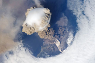
Geological Summary. Sarychev Peak, one of the most active volcanoes of the Kuril Islands, occupies the NW end of Matua Island in the central Kuriles. The andesitic central cone was constructed within a 3-3.5-km-wide caldera, whose rim is exposed only on the SW side. A dramatic 250-m-wide, very steep-walled crater with a jagged rim caps the volcano. The substantially higher SE rim forms the 1496 m high point of the island. Fresh-looking lava flows, prior to activity in 2009, had descended in all directions, often forming capes along the coast. Much of the lower-angle outer flanks of the volcano are overlain by pyroclastic-flow deposits. Eruptions have been recorded since the 1760s and include both quiet lava effusion and violent explosions. Large eruptions in 1946 and 2009 produced pyroclastic flows that reached the sea.
Information Contacts: Sakhalin Volcanic Eruption Response Team (SVERT), Institute of Marine Geology and Geophysics, Far Eastern Branch, Russian Academy of Science, Nauki st., 1B, Yuzhno-Sakhalinsk, Russia, 693022 (URL: http://www.imgg.ru/en/, http://www.imgg.ru/ru/svert/reports); Kamchatka Volcanic Eruptions Response Team (KVERT), Far Eastern Branch, Russian Academy of Sciences, 9 Piip Blvd., Petropavlovsk-Kamchatsky, 683006, Russia (URL: http://www.kscnet.ru/ivs/kvert/); Tokyo Volcanic Ash Advisory Center (VAAC), 1-3-4 Otemachi, Chiyoda-ku, Tokyo 100-8122, Japan (URL: http://ds.data.jma.go.jp/svd/vaac/data/); MIROVA (Middle InfraRed Observation of Volcanic Activity), a collaborative project between the Universities of Turin and Florence (Italy) supported by the Centre for Volcanic Risk of the Italian Civil Protection Department (URL: http://www.mirovaweb.it/); Hawai'i Institute of Geophysics and Planetology (HIGP) - MODVOLC Thermal Alerts System, School of Ocean and Earth Science and Technology (SOEST), Univ. of Hawai'i, 2525 Correa Road, Honolulu, HI 96822, USA (URL: http://modis.higp.hawaii.edu/); Sentinel Hub Playground (URL: https://www.sentinel-hub.com/explore/sentinel-playground).