Report on Nevado del Ruiz (Colombia) — January 2022

Bulletin of the Global Volcanism Network, vol. 47, no. 1 (January 2022)
Managing Editor: Edward Venzke.
Edited by A. Elizabeth Crafford.
Nevado del Ruiz (Colombia) Ash emissions increase in frequency during November-December 2021; dome growth continues
Please cite this report as:
Global Volcanism Program, 2022. Report on Nevado del Ruiz (Colombia) (Crafford, A.E., and Venzke, E., eds.). Bulletin of the Global Volcanism Network, 47:1. Smithsonian Institution. https://doi.org/10.5479/si.GVP.BGVN202201-351020
Nevado del Ruiz
Colombia
4.892°N, 75.324°W; summit elev. 5279 m
All times are local (unless otherwise noted)
Colombia’s broad, glacier-capped Nevado del Ruiz has dated eruptions going back 8,600 years, including observed activity since 1570. Ruiz remained quiet for 20 years after the deadly September 1985-July 1991 eruption until new explosive activity occurred from February 2012 into 2013. Renewed activity beginning in November 2014 included ash and gas-and-steam plumes, ashfall, and the appearance of a slowly growing lava dome inside the Arenas crater in August 2015. Intermittent ash emissions and thermal evidence of dome growth has continued with alternating periods of increased thermal and explosive activity into 2021; daily SO2 emissions are detectable with satellite instruments. This report covers ongoing similar activity from May-December 2021 using information from the Servicio Geologico Colombiano (SGC) and the Observatorio Vulcanológico y Sismológico de Manizales, the Washington Volcanic Ash Advisory Center (VAAC) notices, and satellite information.
Although there were very few thermal anomalies recorded during May-December 2021, the number of ash emissions, and the density of the plumes, increased throughout the period. The Washington VAAC reported only a few sporadic emissions in May, and increased frequency in June. By July they were reported on most days, and during August-October there were very few days when they were not reported. Multiple VAAC reports were issued daily during November and December. Most of the satellite images during May-December were cloud covered. Steam plumes were visible in many images, but thermal anomalies were infrequent and not observed in more than one image per month until December. Small to moderate-sized sulfur dioxide plumes were recorded daily in satellite imagery with plumes drifting in multiple directions (figure 129).
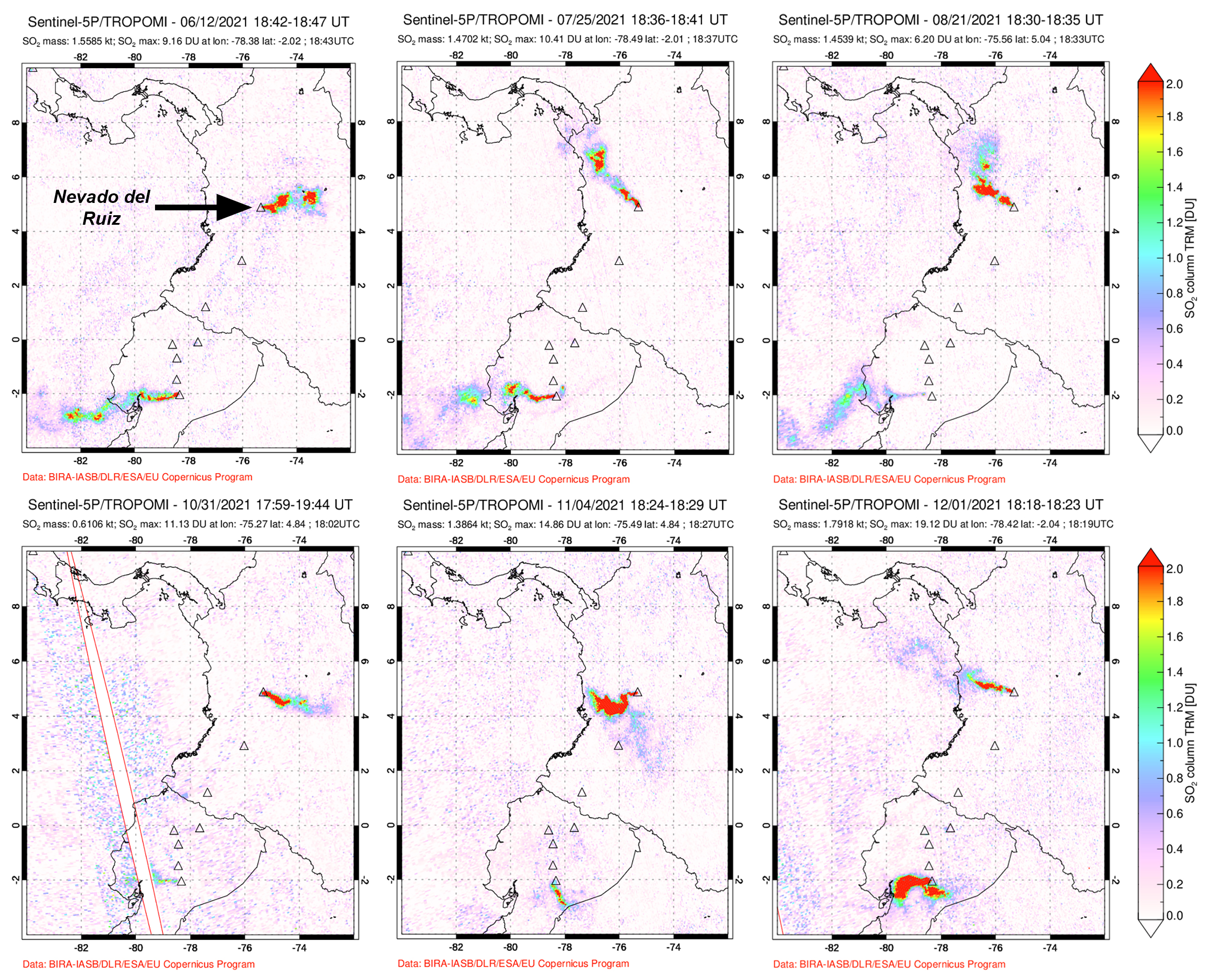 |
Figure 129. Sulfur dioxide emissions from Nevado del Ruiz were recorded daily throughout May-December 2021 with the TROPOMI instrument on the Sentinel-5P satellite. Ecuador’s Sangay (bottom center of images) had similar size plumes most days. Courtesy of NASA Global Sulfur Dioxide Monitoring Page. |
The number of seismic events decreased during May 2021 compared with April but remained the same with respect to the amount of energy released. Continuous tremor, pulsating tremor, LP, and VLP-type seismicity were all recorded. A few of these events were associated with minor ash emissions that were visible in webcams. Episodes of drumbeat seismicity, which SGC associates with growth of the lava dome inside Arenas crater, were reported on 1, 2, 19, and 28-30 May. Steam and gas plumes were recorded daily with plume heights around 1 km on most days. The highest plume, on 31 May, reached 2,700 m above the summit. The Washington VAAC reported an ash emission at 5.8 km altitude drifting NW on 21 May that was not seen in satellite imagery due to clouds, but a similar height plume was observed drifting NW on 27 May.
During June 2021, seismicity increased in the number of events but declined in the amount of energy released relative to May. A few of the seismic events were associated with small emissions of ash confirmed by the webcams. The Washington VAAC reported dense ash emissions drifting NE to about 50 km from the summit at 6.5 km altitude on 11 June. The tallest gas-and-steam plume of the month reached about 2,200 m above the summit that day. A faint thermal anomaly was visible in satellite imagery under a dense white plume on 12 June. An ash plume on 15 June was observed in the summit webcam moving W at 5.8 km altitude. Two days later a plume was observed moving NW at 6.1 km altitude. A possible emission on 23 June drifted W at 5.8 km altitude. Low-energy drumbeat seismicity was recorded on 3, 5-10, 17, 22, 23, and 25 June.
Seismicity increased in both number of events and amount of energy released during July 2021, specifically in the number of pulsating tremors, and in the energy of the continuous tremors. Short-duration, low-energy drumbeat seismicity was recorded on 1, 2, 10, 12-14, 17, 28, and 30 July. The number of ash emissions also increased; they were observed in the webcams, and by residents in communities around the volcano multiple times. Ash was visible up to 90 km NW on 6 July. Ashfall was reported to the WNW in Manizales on the morning of 14 July (figure 130). Three explosions were recorded by the webcams in the morning of 19 July; plume heights rose 420-520 m and drifted WNW. The Washington VAAC issued ash advisories on most days during July. Plume altitudes ranged from 5.8-6.7 km altitude and drifted either W or NW. The maximum height steam and gas plume rose about 2,200 m above the summit on 28 July.
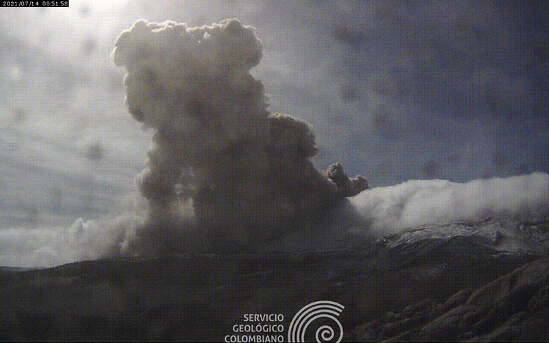 |
Figure 130. A dense ash plume rose from Nevado del Ruiz on the morning of 14 July 2021 and caused ashfall in Manizales. Courtesy of SGC. |
The numbers of pulsating tremor and continuous tremor seismic events, and ash emissions all increased during August 2021; ash emissions were observed in the webcams, by nearby residents, and by SGC and PNNLN (Parque Nacional Natural Los Nevados) personnel working in the area. A weak thermal anomaly was present in satellite imagery under a white plume at the summit on 8 August. Two episodes of low-level drumbeat seismicity, interpreted as dome growth by SGC, were recorded on 22 August. Ash emissions were observed in the webcams on the morning of 26 August that rose 490 m above the summit and drifted WNW (figure 131). The Washington VAAC reported ash emissions almost every day of the month. The plumes reached 5.8-6.4 km altitude and drifted primarily NW but switched to the NE briefly on 15 August.
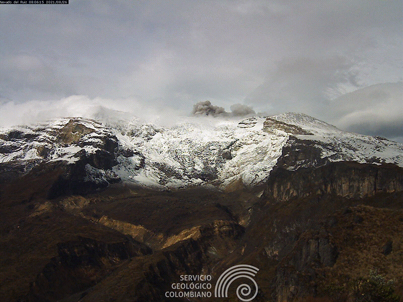 |
Figure 131. Ash emissions rose 490 m above the summit of Nevado del Ruiz on the morning of 26 August 2021 and drifted WNW. Courtesy of SGC. |
The energy level of the continuous tremor events decreased during September 2021 along with the number of pulsating tremors. Drumbeat seismicity was recorded on 17, 19, 22, 27, and 30 September. Park and SGC personnel witnessed small ash emissions that were also confirmed in the webcams. Steam and gas plumes rose as high as 1,500 m above the summit on 6 September. There were only a few days in September when the Washington VAAC did not report ash emissions reaching 5.8-6.4 km altitude and drifting mostly NW.
The energy level of the continuous tremor events rose in October 2021 while the number of seismic events overall remained similar to the previous month. Drumbeat seismicity was recorded on 2, 5, 11-13, 15, and 24-27 October. Ash emissions were confirmed by webcams, Park, and SGC personnel. Some of the increases in the energy of the seismic events corresponded to ash emissions that lasted for several hours. On 3 October the Washington VAAC reported ash emissions that reached 6.7 km altitude and drifted WNW from the summit. Ash emissions on 8 October drifted 35 km NW from the summit at 5.8 km altitude. Intermittent puffs of ash were detected in satellite imagery drifting NNE on 10 October at 6.1 km altitude. Drift direction was more variable during October than September, and ash plumes were reported daily from 3 October through the end of the month at altitudes of 5.8-6.7 km. On the morning of 18 October ashfall was reported in several areas of Manizales. The highest gas-and-steam plume of the month rose to 2,400 m above the summit on 29 October. Gas-and-ash emissions were captured in webcam images early on 29 October (figure 132). A faint thermal anomaly was present in Sentinel satellite imagery on 30 October under a dense white plume.
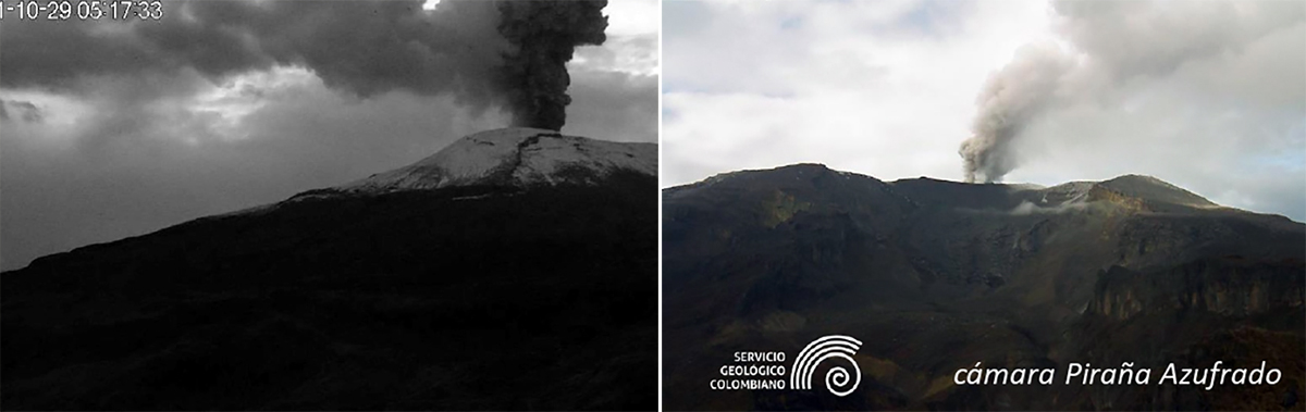 |
Figure 132. Gas and ash emissions at Nevado del Ruiz were captured multiple times in webcam images on 29 October 2021. Courtesy of SGC. |
Similar activity continued during November and December 2021, with extended periods of ash emissions reported a number of times, observed in webcams and by personnel in the field. SGC reported an ash plume visible in webcams early on 1 November that reached 2,500 m above the summit and drifted NE (figure 133). Continuous ash emissions associated with a seismic tremor signal were reported in the morning of 7 November rising 500 m and drifting WNW, causing trace amounts of ashfall in Manizales and Villamaria (figure 134). The airport in La Nubia briefly suspended operations as a result of the ashfall. SGC officials needed to clear ash off the solar panels of the monitoring stations at the volcano on 9, 10, and 11 November after emissions during the previous days (figure 135). Daily steam and gas plumes usually rose to heights of 1,500-1,800 m above the summit. Multiple daily reports from the Washington VAAC confirmed ongoing ash emissions that rose to altitudes of 5.8-6.7 km through the end of the year. They were observed as far as 75 km NW from the volcano on 6 November, and similar distances on several other occasions. Ash could be seen in Sentinel satellite imagery on 24 November. Trace amounts of ashfall were also reported during the morning of 26 November in various sectors of Manizales. Continuous ash emissions were observed in satellite imagery moving W from the summit at 7 km altitude on 29 November.
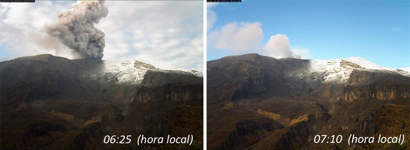 |
Figure 133. SGC reported an ash plume at Nevado del Ruiz visible in webcams early on 1 November 2021 that reached 2,500 m above the summit and drifted NE. Courtesy of SGC. |
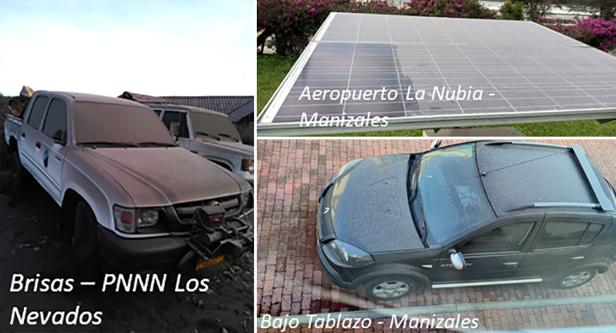 |
Figure 134. Continuous ash emissions associated with a seismic tremor signal at Nevado del Ruiz were reported in the morning of 7 November 2021 rising 500 m and drifting WNW causing trace amounts of ashfall in the Park, Villamaria, and briefly halting flights at La Nubia airport in Manizales. Courtesy of SGC. |
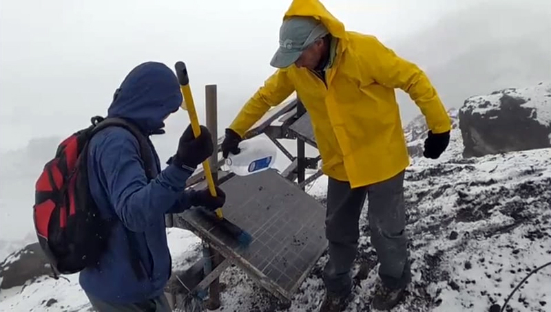 |
Figure 135. SGC staff needed to clear ash off solar panels at the Nevado del Ruiz monitoring stations on 9, 10, and 11 November 2021 after emissions during the previous days. Courtesy of SGC. |
Steam and gas plumes usually rose 1,500-1,800 m above the summit during December 2021 but reached 2,650 m on 12 December. The only clear Sentinel satellite image of the dome inside Arenas crater during the period was on 14 December, when a ring-shaped thermal anomaly was recorded (figure 136). Trace amounts of ashfall were reported in Manizales and Villamaria on 17 and 18 December from gas and ash emissions during those days. Ash emissions were also visible in the webcams early on 23 December. On 24 December, two thermal anomalies were recorded through a diffuse meteoric cloud cover. Low-energy drumbeat seismicity returned on 29 and 30 December. SGC reported that analysis of satellite imagery indicated that the dome appeared to lose volume during the last days of the month.
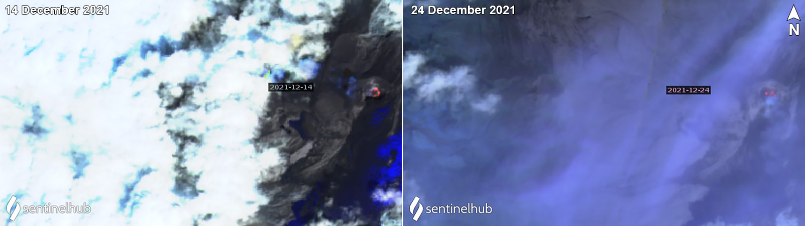 |
Figure 136. Thermal anomalies at Nevado del Ruiz in Sentinel-2 satellite data were infrequent during May-December 2021. The only day of the period when a clear ring-like anomaly inside the crater was recorded was on 14 December (left). Two small anomalies appeared below diffuse clouds on 24 December (right). Images use Atmospheric penetration rendering (bands 12, 11, 8a). Courtesy of Sentinel Hub Playground. |
Geological Summary. Nevado del Ruiz is a broad, glacier-covered volcano in central Colombia that covers more than 200 km2. Three major edifices, composed of andesitic and dacitic lavas and andesitic pyroclastics, have been constructed since the beginning of the Pleistocene. The modern cone consists of a broad cluster of lava domes built within the caldera of an older edifice. The 1-km-wide, 240-m-deep Arenas crater occupies the summit. The prominent La Olleta pyroclastic cone located on the SW flank may also have been active in historical time. Steep headwalls of massive landslides cut the flanks. Melting of its summit icecap during historical eruptions, which date back to the 16th century, has resulted in devastating lahars, including one in 1985 that was South America's deadliest eruption.
Information Contacts: Servicio Geologico Colombiano (SGC), Diagonal 53 No. 34-53 - Bogotá D.C., Colombia (URL: https://www.sgc.gov.co/volcanes); Washington Volcanic Ash Advisory Center (VAAC), Satellite Analysis Branch (SAB), NOAA/NESDIS OSPO, NOAA Science Center Room 401, 5200 Auth Rd, Camp Springs, MD 20746, USA (URL: www.ospo.noaa.gov/Products/atmosphere/vaac, archive at: http://www.ssd.noaa.gov/VAAC/archive.html); Sentinel Hub Playground (URL: https://www.sentinel-hub.com/explore/sentinel-playground); NASA Global Sulfur Dioxide Monitoring Page, Atmospheric Chemistry and Dynamics Laboratory, NASA Goddard Space Flight Center (NASA/GSFC), 8800 Greenbelt Road, Goddard MD 20771, USA (URL: https://so2.gsfc.nasa.gov/).