Report on Hunga Tonga-Hunga Ha'apai (Tonga) — February 2022
Bulletin of the Global Volcanism Network, vol. 47, no. 2 (February 2022)
Managing Editor: Edward Venzke.
Edited by A. Elizabeth Crafford.
Hunga Tonga-Hunga Ha'apai (Tonga) Surtseyan explosions begin on 20 December 2021; large ash plumes and island growth
Please cite this report as:
Global Volcanism Program, 2022. Report on Hunga Tonga-Hunga Ha'apai (Tonga) (Crafford, A.E., and Venzke, E., eds.). Bulletin of the Global Volcanism Network, 47:2. Smithsonian Institution. https://doi.org/10.5479/si.GVP.BGVN202202-243040
Hunga Tonga-Hunga Ha'apai
Tonga
20.5532°S, 175.3841°W; summit elev. 114 m
All times are local (unless otherwise noted)
The Hunga Tonga-Hunga Ha’apai volcano includes small islands and shallow submarine reefs along the caldera rim of a much larger submarine edifice in the western South Pacific Ocean (figure 25), west of the main inhabited islands in the Kingdom of Tonga. It is one of 12 confirmed submarine volcanoes along the Tofua Arc, a segment of the larger Tonga-Kermadec volcanic arc. The Tonga-Kermadec arc formed as a result of subduction of the Pacific Plate beneath the Indo-Australian Plate. The capital city of Tonga, Nuku’alofa, is located 65 km S on the island of Tongatapu. New Zealand lies 2,000 km S, and Australia is over 3,000 km SW. Evidence for at least two caldera-forming eruptions was present in the volcanic stratigraphy on the island (Brenna et al, 2022); five eruptions have been documented since 1900. This report provides a summary of previous activity through 2015, followed by information on new eruptive activity that began on 20 December 2021 until a pause in the eruption on 5 January 2022. Subsequent reports will cover details of the large 14-15 January 2022 events. Primary sources of information include the Tonga Geological Services (TGS), Tongan and New Zealand news outlets, the Wellington Volcanic Ash Advisory Center (VAAC), and satellite information from multiple sources.
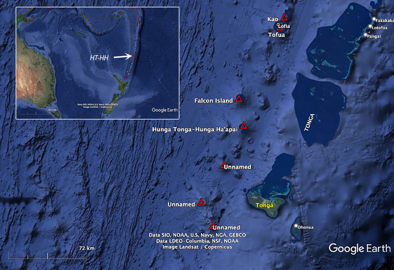 |
Figure 25. Hunga Tonga-Hunga Ha’apai volcano in the SW Pacific is 65 km NW of the island of Tongatapu, where the capital of the Kingdom of Tonga, Nuku’alofa, is located. It lies 2,000 km N of New Zealand and over 3,000 km NE of Australia. Several submarine volcanoes along the Tofua arc are shown in red triangles. The Tonga-Kermadec trench lies to the east of the volcanic arc. Courtesy of Google Earth. |
Eruptive activity during 1912-2015. Eruptions were recorded at Hunga Tonga-Hunga Ha’apai in 1912, 1937, 1988, 2009, and 2014-2015 (figure 26). The eruptions of 1912 and 1937 were located at a group of shallow reefs about 3 km S of Hunga Tonga island (Brenna et al., 2022), on the SE caldera rim. Fisherman witnessed an eruption in June 1988 near the same reefs which included large volumes of dense steam, tephra, and incandescent ejecta (SEAN 13:05). The tephra erupted from three vents, aligned SW-NE, but there was no evidence of an island above sea level after the activity subsided.
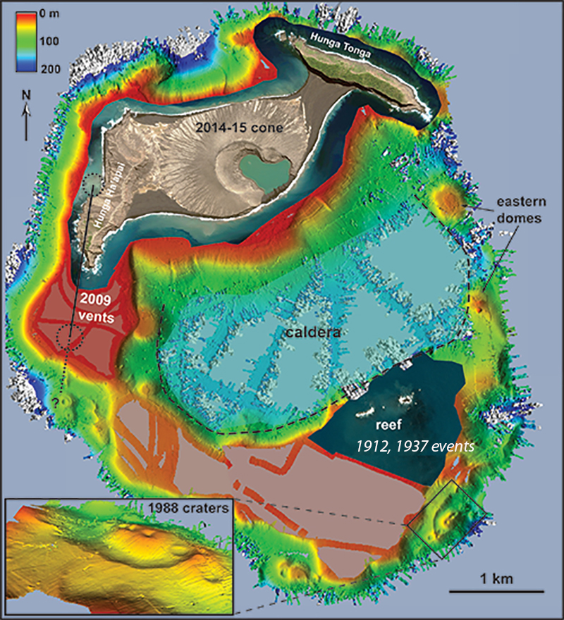 |
Figure 26. A bathymetric sonar survey of the seafloor near the islands of Hunga Tonga and Hunga Ha‘apai, conducted in November 2015, shows the summit platform of the submerged volcanic edifice and the locations of recorded eruptions. The dashed black line outlines a previous caldera which lies 150-180 m below the surface. Traces of past eruptions along the caldera rim are clearly visible; the inset gives the locations of the 1988 eruptions in greater detail. Areas colored white represent depths greater than 200 m, beyond the range of the sonar system. Modified from figure 2 in Cronin et al.(2017). |
In March 2009 a new eruption that lasted for several days was witnessed by airline passengers in the vicinity (BGVN 34:02). Dense steam plumes, both rising vertically and spreading across the water surface, were accompanied by black ash-laden eruption plumes from two separate vents that rose as high as 7.6 km altitude and drifted NE. Pumice rafts drifted tens of kilometers from the site. By the time activity subsided, a new vent had emerged above sea level, extending Hunga Ha’apai island by about 1 km to the S. The crater of the new vent was about 350 m in diameter and began to erode away soon after it formed. The second vent was located immediately W of the island (figure 27). By November 2013 there was no longer any trace of the vents from the 2009 eruption (figure 28).
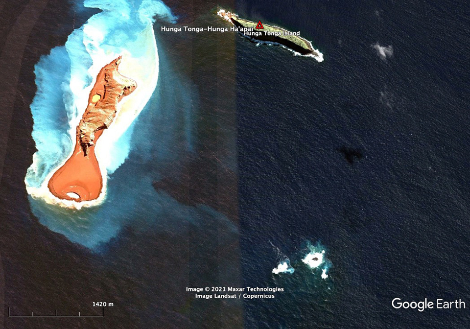 |
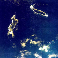
Figure 27. Satellite image of the separate islands of Hunga Tonga (top right) and Hunga Ha’apai (left) on 14 June 2009. Two craters formed in the March 2009 eruption; one is immediately W of the center of the island, and the second, about 1 km S of Hunga Ha’apai, was about 350 m wide. They began to erode as soon as they formed and had lost significant volume by three months later when this image was captured. The reefs in the lower right are the site of the 1912 and 1937 eruptions. Vertical lines of different color are processing artifacts of older images. Courtesy of Google Earth. |
 |
Figure 28. Hunga Tonga (top right) and Hunga Ha’apai (left) islands on 14 November 2013 after material added to Hunga Ha’apai during the 2009 eruption had eroded away. Courtesy of Google Earth. |
An eruption during December 2014-January 2015 (BGVN 40:01) built a pyroclastic cone over 100 m in elevation in the area between Hunga Ha’apai and Hunga Tonga islands; it initially created a separate island but was later joined to the others (figure 29) due to water moving the unconsolidated tephra. Fishermen had first observed this eruption in mid-December, and a kilometer-high steam plume was visible from Tongatapu on the 30th. Vigorous emissions of black ash and billowing white clouds were reported on 6 January 2015, with plumes below 2 km altitude. Activity increased during 12-14 January, producing 6-km-high plumes and causing cancellation of numerous airline flights. Repeated explosions ejected rock and ash 400 m above the ocean and produced multiple basal surges that extended up to 1 km out from the vent. Ashfall was noted in a 10 km radius, destroying vegetation on both islands. By 17 January steam emissions were rising to heights of 7-10 km but contained only minor amounts of ash; the new island was quiet when visited by Tongan officials on 24 January.
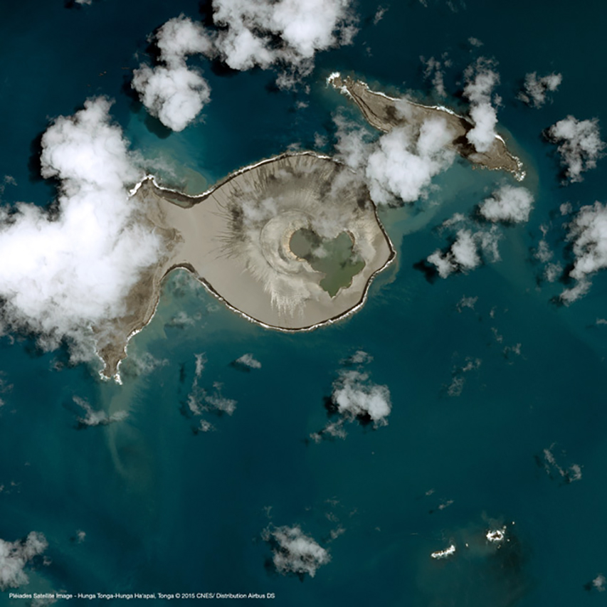 |
Figure 29. This CNES Pléiades satellite image (50-m resolution, optical band) taken on 19 January 2015 shows the new island formed during the December 2014-January 2015 eruption. Tephra from the new cone joins it to the E side of Hunga Ha'apai island on the left, while it is not yet connected to Hunga Tonga island on the right. Accessed in March 2015 (figure 20, BGVN 40:01). |
Bathymetric mapping in April 2016 clarified the extent of the submarine portion of the edifice, which rises more than 2,000 m from the surrounding seafloor (figure 30). No volcanic activity was reported from February 2015 through November 2021; satellite imagery acquired during this time shows gradual erosion of the 2015 cone, and continued growth of the beach areas from ocean currents around the island.
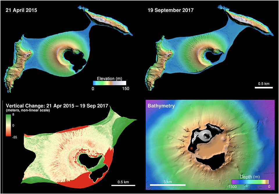 |
Figure 30. Digital Elevation Models (DEMs) of Hunga Tonga-Hunga Ha’apai from April 2015 and September 2017 (top row) indicated the extent of erosion and sediment redeposition that occurred during that time. The lower left panel illustrates the difference of the two DEMs illustrated above, with areas of erosion in red and accretion in green (with levels shown in meters). The lower right panel depicts the bathymetry (5 m ground sample distance) of the larger submarine edifice, as measured from the R/V Falkor in April 2016. The red asterisk indicates the location of the 2009 eruption (Vaughan and Webley, 2010) which washed away after a few months. Original is figure 3 in Garvin et al. (2018). |
Eruptive activity during 20 December 2021-5 January 2022. Tonga's head geologist, Taaniela Kula, confirmed that an ash eruption from Hunga Tonga-Hunga Ha’apai started at about 0935 local time on 20 December 2021 according to the Matangi Tonga Online news website. The initial plume, described as primarily steam and gas without identifiable ash, and having a 30-km radius, was reported by the Wellington VAAC at about 6 km altitude. Kula reported it rising to 16 km later in the day and drifting N; he also told RNZ Pacific that by the afternoon “ash had dusted the whole of Tonga.” He further noted that the plume had reached the Vava’u Islands (250 km NE) and Fonualei Island (300 km NNE) before 1700, it reached Niuafo’ou (550 km N) by 1900, and Niuatoputapu and Tafahi Islands (550 km NE) by 2100 that evening. On Vava’u loud explosions were noted by Scott Bryan several times a minute for the first 1-2 hours; they continued to be heard for 12 hours after the eruption began. Images from Himawari-8 and Korean GeoKompsat weather satellites, and photography from air passengers, confirmed a high-altitude plume (figure 31).
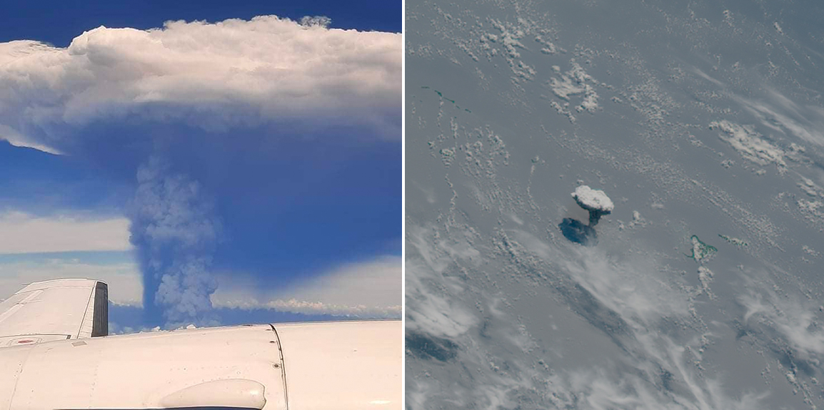 |
Figure 31. Ash and steam rose as high as 16 km from Hunga Tonga-Hunga Ha’apai on 20 December 2021 (local time). Left photo by air passenger Kimberlyn Hoyla on a flight between Tongatapu and Vava’u, courtesy of The Pacific Newsroom. Satellite image (right) from Korea's GeoKompsat weather satellite courtesy of Simon Proud. |
Lightning in the eruption plume was observed from Nuku’alofa on Tongatapu (65 km SE) overnight on 20-21 December. By the next morning the ash cloud had dispersed and a steam-rich plume at 12.2 km altitude was detected drifting NE in satellite imagery; it was also clearly visible from Tongatapu (figure 32). A Maxar satellite image taken on 21 December confirmed that the new vent was very close to the 2014-2015 site, and also showed dark tephra within the plume (figure 33). Pilots reported intermittent eruption plumes ranging from 6-12 km altitude that day; weather satellites also detected continuous pulses of plumes. Multiple bursts of lightning continued to be reported during the next several evenings, visible from Nuku'alofa and the Kanokupolu coast (figure 34).
 |
Figure 32. A steam-rich plume from Hunga Tonga-Hunga Ha'apai rising several kilometers high was seen from Kanokupolu Beach, Tongatapu, at about 1530 on 21 December 2021. Photo by Shane Egan, courtesy of Matangi Tonga Online. |
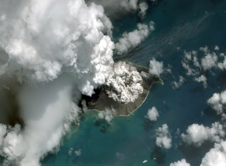 |
Figure 33. Maxar Technologies imagery from 21 December 2021 of Hunga Tonga-Hunga Ha’apai confirmed that the new eruption emerged from the same general area as the 2014-2015 vent. Courtesy of Murray Ford and Maxar Technologies. |
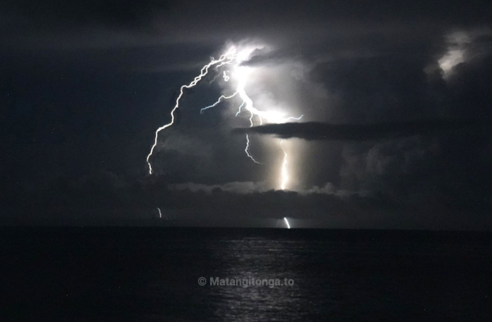 |
Figure 34. Intermittent lightning from Hunga Tonga-Hunga Ha'apai was seen by many Nuku'alofa residents on the evening of 22 December 2021. Photo by Mary Lyn Fonua, courtesy of Matangi Tonga Online. |
The Tonga Geological Services (TGS) reported to Matangi Tonga Online that plumes with sulfur dioxide continued to spread over the Ha'apai, Vava'u, and Niuatoutapu island groups on 22 and 23 December, drifting NNE at altitudes of 8-14 km. They noted that the steam plumes were significantly less dense by the morning of 23 December. The Wellington VAAC reported plumes still visible in satellite imagery at 10.9 km altitude drifting NE early that day but dropping to 6 km altitude later. The first ground-based images of the eruption came from a Tonga Navy crew near the island on 23 December. They recorded Surtseyan explosions ejecting tephra 350 m high, billowing steam plumes rising kilometers, and steam bursts travelling horizontally out from the vent (figure 35). Pulses of steam and gas emissions continued rising to 10.3-12.2 km altitude during 24-27 December, while ash rose only to 3 km; ashfall was confined to the vicinity of the volcano. Tonga’s head geologist reported to RNZ Pacific that satellite images from 25 December showed that the island had grown 300-600 m on the E side, and ash was falling within a 10 km radius. Air travel to Tonga was interrupted by eruption plumes multiple times during the second half of December.
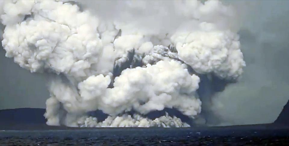 |
Figure 35. Video of Hunga Tonga-Hunga Ha’apai erupting on 23 December 2021 was taken by Sione Vailala Lataimaumi of His Majesty’s Armed Forces of Tonga. This screenshot shows dark tephra being ejected several hundred meters above the vent while billowing steam plumes rose several kilometers and extended horizontally along the ocean surface. Courtesy of Alakihihifo Vailala. |
The altitude of the upper-level steam and gas plumes decreased to 9 km during 27-28 December; a pulse later in the day increased the altitude of the ash cloud from 3 to 3.7 km and the steam and gas cloud to 16 km. Matangi Tonga Online reported powerful lightning bursts overnight on 28-29 December, and volcanic ash was detected 1-7 km above sea level. The ash cloud was reported at 6.1 km altitude early on 29 December, but from midday onward, only steam and gas drifting N at 7.6-12.2 km was reported by the Wellington VAAC. TGS reported on 29 December that the eruption continued intermittently throughout the day, with steam and gas plumes containing small amounts of ash drifting NNW at altitudes up to 18 km. Ash was detected in satellite imagery within 40 km of the vent in all directions in the morning. Passengers on a small South Seas Charters boat witnessed multiple Surtseyan explosions on 29 December with jets of black tephra and dense steam rising up and out from the vent, and ash falling from the drifting plumes (figure 36). Several surges of Surtseyan activity, with some periods lasting as long as 30 minutes, occurred overnight during 29-30 December local time; similar activity during the midday of 30 December was photographed by TGS (figures 37 and 38). The ash and steam drifted N, passing to the W of Tofua (90 km NNE), Kao (100 km NNE), and Late (200 km NNE) islands. Rafts of pumice were seen floating in the water several kilometers from the vent (figure 39).
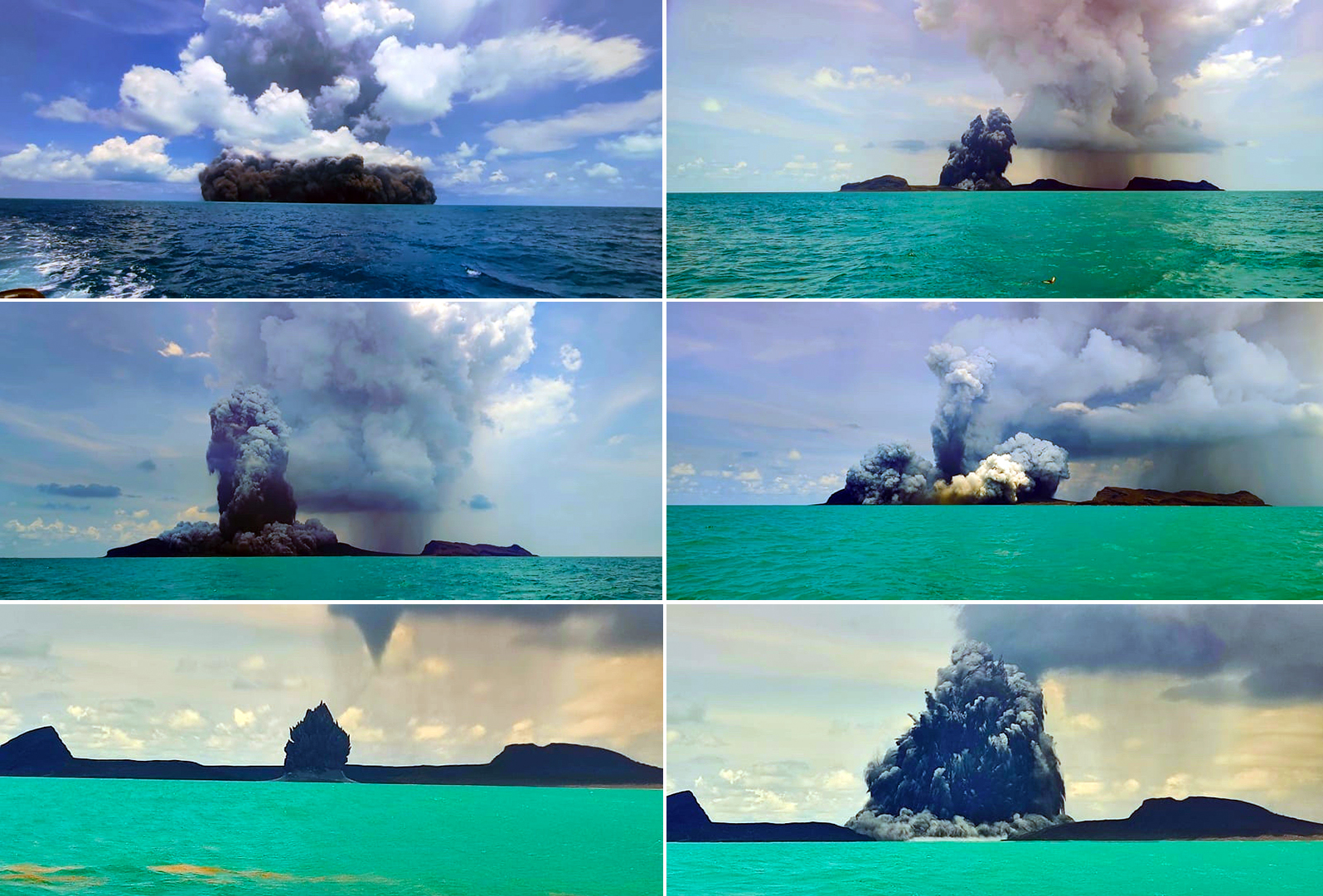 |
Figure 36. Passengers on a small South Seas Charters boat witnessed multiple Surtseyan explosions from Hunga Tonga-Hunga Ha’apai on 29 December 2021, with jets of black tephra and dense steam rising up and out from the vent, and ash falling from the drifting plumes. View is looking SE. Courtesy of GP Orbassano, used with permission. |
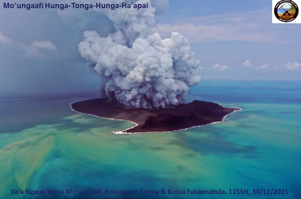 |
Figure 37. Personnel from the Tonga Geological Services and Tonga Navy used a UAV to video multiple intermittent Surtseyan explosions of tephra, steam, and gas at Hunga Tonga-Hunga Ha’apai on 30 December 2021. Courtesy of Tonga Geological Services. |
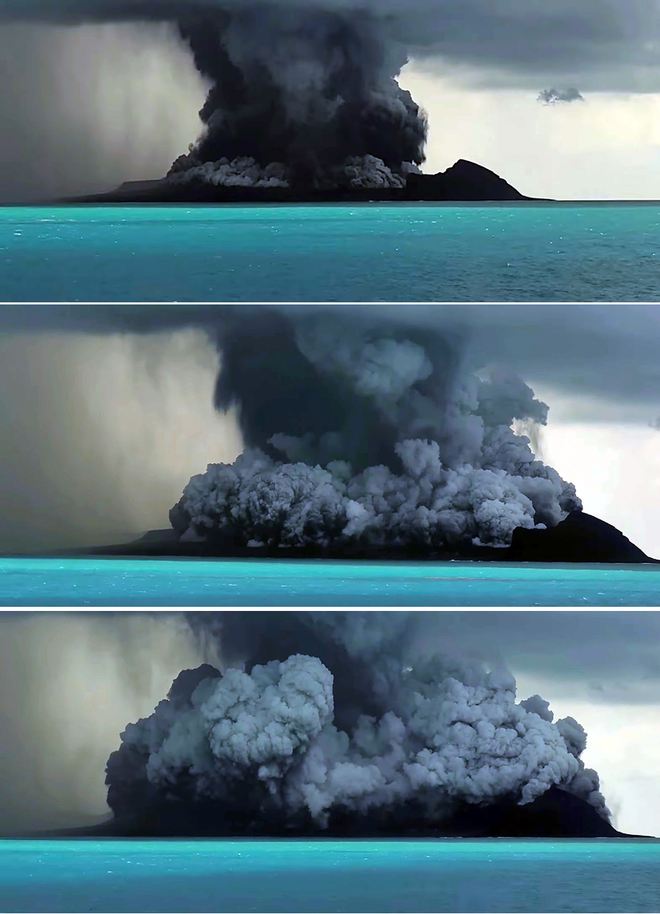 |
Figure 38. Tongan Geological Services scientists witnessed multiple Surtseyan explosions at Hunga Tonga-Hunga Ha’apai on 30 December 2021. These three screen shots from their video span about 30 seconds. In the top image, a dense plume of black tephra and steam has just exploded from the vent sending ash and steam into a dense atmospheric cloud; ash is raining down around the island. The following images show a basal surge of steam, gas, and tephra rising up and outward from the vent. Courtesy of Tonga Geological Services. |
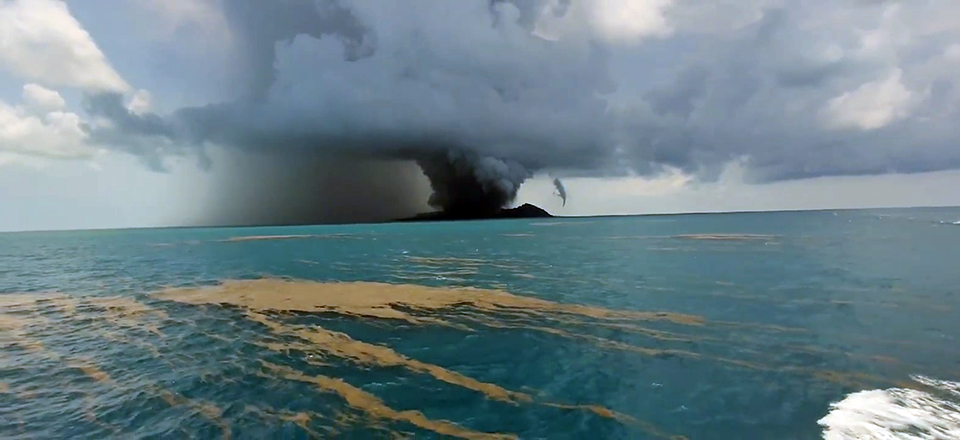 |
Figure 39. Rafts of pumice were visible in the water several kilometers from the erupting Hunga Tonga-Hunga Ha’apai on 30 December 2021. Courtesy of Tonga Geological Services. |
In a public notice released at 0700 on the morning of 31 December, TGS noted that ash had been detected during the prior evening, with the plume drifting N to the W of Ha’apai and Vava’u Islands at altitudes of 4-18 km. Ash was last detected in satellite images 30 km S of Niuafo’ou (550 km N) at 0150 on 31 December. They detected only steam and gas at 0430 later that morning drifting NNE at about 12 km altitude. The following day, 1 January 2022, intermittent gas and steam eruptions continued, but no ash was reported after 1200. Plumes drifted E across the ‘Otu Mu’omu’a Islands of the Ha’apai Group (130 km NE) at an estimated altitude of 12 km. The next morning, 2 January, they drifted ESE across the Tongatapu waters. TGS reported on the morning of 3 January that no ash, steam, or gas emissions had been observed for 24 hours. A small ash plume was detected between 2220 and 2230 that evening at 5-7 km altitude located 5-10 km NE of the volcano. Just after midnight on 4-5 January a minor ash plume was detected at 8 km altitude about 15 km N of the volcano that dissipated after about 30 minutes; this was the last ash emission observed during this series of events.
A substantial sulfur dioxide plume of nearly 9 kilotons was released on 20 December 2021 at the beginning of the eruption; plumes with 6-13 kilotons of SO2 drifted daily over the Pacific Ocean during 22 December-1 January 2022 (figure 40). A large area of pumice rafts around 10 km wide was visible in Sentinel 2 satellite imagery drifting almost 100 km W of the volcano on 2 January 2022 (figure 41). Dark pumice washed up on the northwestern beaches of Tongatapu Island on 5 January (figure 42). A clear satellite image of the island on 7 January 2021 revealed the extent of the growth of Hunga Tonga-Hunga Ha’apai during the eruptive activity of 20 December 2021-5 January 2022 (figure 43). A second subaerial vent had appeared to the E of the original 2015 vent and was surrounded on the E and S by a wide apron of tephra connecting the vent to the older Hunga Tonga Island to the NE.
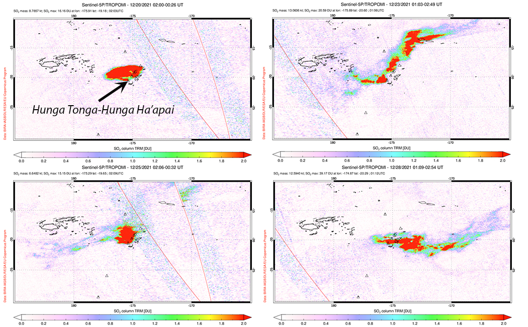 |
Figure 40. A large plume of SO2 that measured about 9 kilotons was released from Hunga Tonga-Hunga Ha’apai on 20 December 2021 at the start of the eruption. Sulfur dioxide plumes of 6-13 kilotons were released daily during 22 December 2021-1 January 2022. Courtesy of NASA Global Sulfur Dioxide Monitoring Page. |
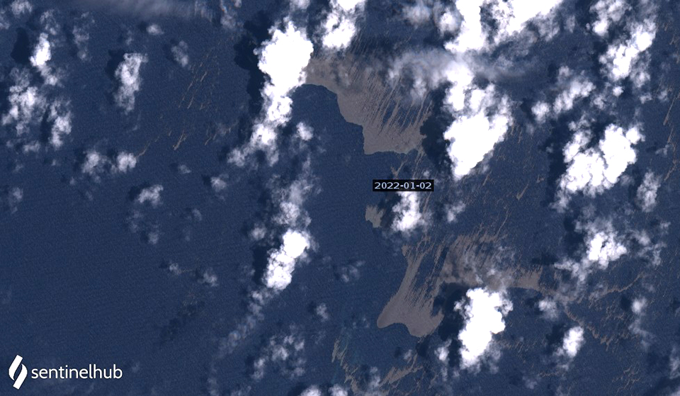 |
Figure 41. Large rafts of pumice from Hunga Tonga-Hunga Ha’apai were visible in Sentinel 2 satellite imagery on 2 January 2022. Each brown area is about 4 km in its widest dimension, and they were located nearly 100 km WSW of the volcano. Image uses Natural color rendering (bands 4, 3, 2). Courtesy of Sentinel Hub Playground. |
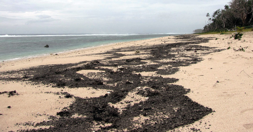 |
Figure 42. Dark pumice, presumed to be from Hunga Tonga-Hunga Ha’apai, washed up on Kanokupolu Beach, 60 km S on the northwestern coast of Tongatapu Island on 5 January 2022. Photo by Shane Egan, courtesy of Matangi Tonga Online. |
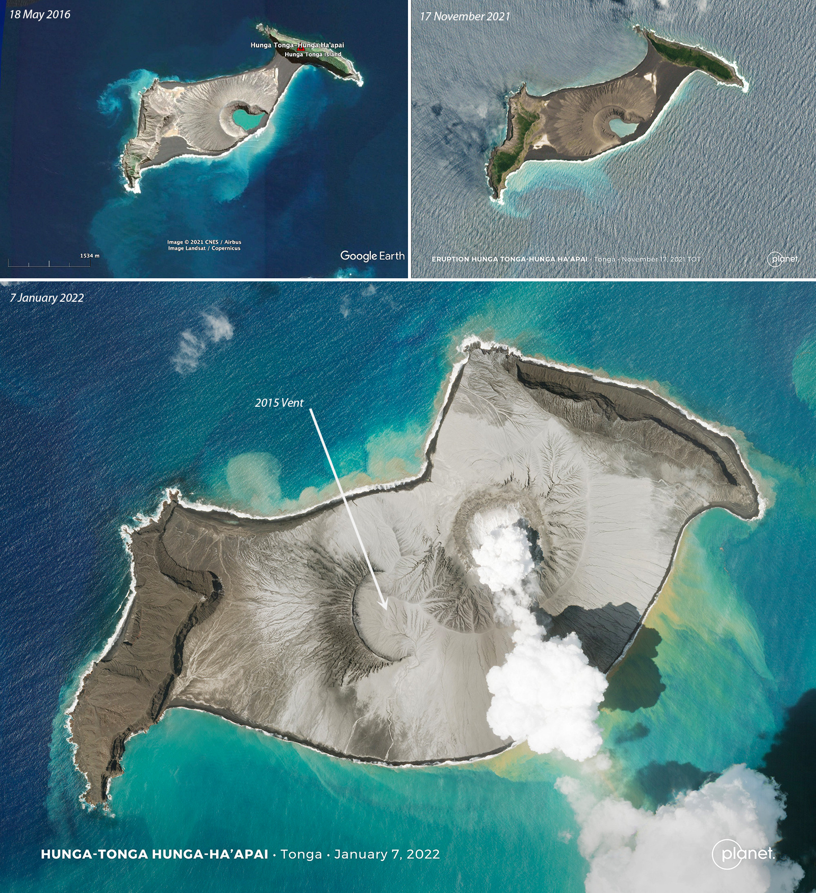 |
Figure 43. Hunga Tonga-Hunga Ha’apai grew significantly during the eruptive activity that occurred between 20 December 2021 and 5 January 2022 as compared with very little change in its shape since 2016. The top images show the island on 18 May 2016 (left) and 17 November 2021 (right) and the bottom image shows the island on 7 January 2022. A new vent grew above sea level to the NE of the 2015 vent and a large apron of tephra connected the vent to the older Hunga Tonga Island to the NE and surrounded it to the S. 18 May 2016 image courtesy of Google Earth, 17 November 2021 and 7 January 2022 images courtesy of Planet.com and Tanya Harrison. |
References:
Cronin S J, Brenna M, Smith I E M, Barker S J, Tost M, Ford M, Tonga’onevai S, Kula T, Vaiomounga R, 2017. New volcanic island unveils explosive past. Eos, 98 (26 June 2017). https://doi.org/10.1029/2017EO076589
Garvin J B, Slayback D A, Ferrini V, Frawley J, Giguere C, Asrar G R, Andersen K, 2018. Monitoring and modeling the rapid evolution of Earth’s newest volcanic island: Hunga Tonga Hunga Ha’apai (Tonga) using high spatial resolution satellite observations . Geophysical Research Letters, 45: 3445-3452. https://doi.org/10.1002/2017GL076621
Brenna M, Cronin S J, Smith I E M, Pontesilli A, Tost M, Barker S, Tonga’onevai S, Kula T, Vaiomounga R, 2022. Post-caldera volcanism reveals shallow priming of an intra-ocean arc andesitic caldera: Hunga volcano, Tonga, SW Pacific. Lithos, 412-413, 106614. https://doi.org/10.1016/j.lithos.2022.106614
Geological Summary. The small andesitic islands of Hunga Tonga and Hunga Ha'apai are part of the western and northern remnants of the rim (~6 km diameter) of a largely submarine caldera located about 30 km SSE of Falcon Island. The topmost sequence of welded and unwelded ignimbrite units from a caldera-forming eruption was 14C dated to 1040-1180 CE (Cronin et al., 2017; Brenna et al. 2022). At least two additional welded pumice-rich ignimbrite units and nonwelded pyroclastic flow deposits, below paleosols and other volcaniclastic deposits, indicated more very large previous eruptions (Cronin et al., 2017; Brenna et al. 2022). Several submarine eruptions have occurred at this caldera system since the first recorded eruption in 1912, including 1937 and S of the islands in 1988. A short eruption in 2009 added land to to Hunga Ha'apai. At that time the two islands were each about 2 km long, displaying inward-facing sea cliffs with lava and tephra layers dipping gently away from the caldera. An eruption during December 2014-January 2015 was centered between the islands, and combined them into one larger structure. Major explosive eruptions in late 2021 initially reshaped the central part of the combined island before stronger activity in mid-January 2022 removed most of the 2014-15 material; an even larger eruption the next day sent an eruption plume high into the stratosphere, triggered shock waves through the atmosphere and tsunami across the Pacific Ocean, and left only small remnants of the islands above the ocean surface.
Information Contacts: Tonga Geological Services, 51 Vaha'akolo Road, Nuku’alofa, Tonga (URL: https://www.facebook.com/tongageologicalservice); Matangi Tonga Online (URL: https://matangitonga.to/); RNZ Pacific (URL: https://www.rnz.co.nz); Wellington Volcanic Ash Advisory Centre (VAAC), Meteorological Service of New Zealand Ltd (MetService), PO Box 722, Wellington, New Zealand (URL: http://www.metservice.com/vaac/, http://www.ssd.noaa.gov/VAAC/OTH/NZ/messages.html); Google Earth (URL: https://www.google.com/earth/); Planet Labs, Inc. (URL: https://www.planet.com/); Tanya Harrison, Planet Labs, Inc. (URL: https://twitter.com/tanyaofmars/status/1483560804226109444); Scott Bryan, Queensland University of Technology (QUT), Brisbane, QLD 4001, Australia (URL: https://www.qut.edu.au/about/our-people/academic-profiles/scott.bryan); The Pacific Newsroom (URL: https://www.facebook.com/groups/Pacificnewsroom); Simon Proud (https://twitter.com/simon_sat/status/1472852455708889089); Maxar Technologies (URL: https://www.maxar.com/); Murray Ford (URL: https://twitter.com/mfordNZ/status/1473509942090813441); Alakihihifo Vailala (URL: https://twitter.com/alakihihifo/status/1473997579373318147); NASA Global Sulfur Dioxide Monitoring Page, Atmospheric Chemistry and Dynamics Laboratory, NASA Goddard Space Flight Center (NASA/GSFC), 8800 Greenbelt Road, Goddard MD 20771, USA (URL: https://so2.gsfc.nasa.gov/); Sentinel Hub Playground (URL: https://www.sentinel-hub.com/explore/sentinel-playground); GP Orbassano (URL: https://www.facebook.com/gp.tonga/posts/1742471535946154).