Report on Langila (Papua New Guinea) — February 2022

Bulletin of the Global Volcanism Network, vol. 47, no. 2 (February 2022)
Managing Editor: Edward Venzke.
Edited by Kadie L. Bennis.
Langila (Papua New Guinea) Thermal anomalies, ash plumes, and sulfur dioxide plumes during May-December 2021
Please cite this report as:
Global Volcanism Program, 2022. Report on Langila (Papua New Guinea) (Bennis, K.L., and Venzke, E., eds.). Bulletin of the Global Volcanism Network, 47:2. Smithsonian Institution. https://doi.org/10.5479/si.GVP.BGVN202202-252010
Langila
Papua New Guinea
5.525°S, 148.42°E; summit elev. 1330 m
All times are local (unless otherwise noted)
Langila consists of a group of four small overlapping cones and is located at the W tip of Papua New Guinea’s New Britain Island. Frequent mild-to-moderate explosive eruptions with ash emissions have been recorded since the 19th century from three active summit craters. The current eruption period began in October 2015 and has recently been characterized by intermittent low-level thermal activity, ash plumes, and sulfur dioxide plumes (BGVN 46:05). Similar activity continued during this reporting period of May through December 2021 using information primarily from the Darwin Volcanic Ash Advisory Center (VAAC) and satellite images.
Volcanism remained similar to recent activity. MIROVA recorded intermittent thermal activity at the summit during the reporting period, though between June and September the number and frequency of anomalies was low; during October through November, thermal activity increased (figure 25). According to the MODVOLC hotspot system, thermal anomalies were detected on 1, 15, and 20 October, 9 and 25 November, and 2 December. On clear weather days these small anomalies were visible in the summit crater in Sentinel-2 infrared satellite imagery, sometimes accompanied by gas-and-steam emissions (figure 26).
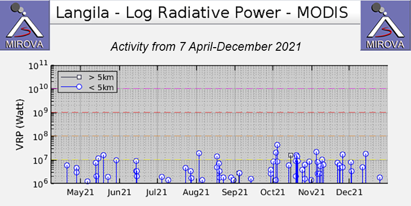 |
Figure 25. Intermittent thermal activity at Langila was shown in the MIROVA graph (Log Radiative Power) during May through December 2021. Activity was relatively low in both strength and frequency between June and September compared to October through December. Courtesy of MIROVA. |
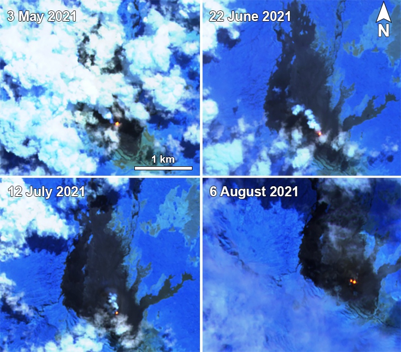 |
Figure 26. Sentinel-2 infrared satellite imagery showed a thermal anomaly at the summit of Langila on 3 May (top left), 22 June (top right), 12 July (bottom left), and 6 August (bottom right) 2021, sometimes accompanied by gas-and-steam emissions, as shown on 22 June and 12 July. On 6 August two thermal anomalies were observed at the summit. Sentinel-2 satellite images with “Atmospheric penetration” (bands 12, 11, 8A) rendering. Courtesy of Sentinel Hub Playground. |
The NASA Global Sulfur Dioxide page, which shows data from the TROPOMI instrument on the Sentinel-5P satellite, showed intermittent weak sulfur dioxide plumes during July through December that drifted in different directions (figure 27). Occasional ash plumes were reported by the Darwin VAAC beginning on 3 May when an ash plume rose to 1.5 km altitude and drifted NE, based on HIMAWARI-8 satellite imagery, which was also accompanied by a thermal anomaly (figure 26). On 15 May an ash plume rose to 3 km altitude and drifted in two directions: S and NW. During 13-14 June ash plumes rose to 2.1-3 km altitude and drifted WNW and W, respectively. An ash plume that rose to 2.4 km altitude drifted WNW and W on 20 August and 11-12 September; a hotspot was also observed at the summit in satellite imagery during those days, according to the Darwin VAAC. A strong ash plume on 21 October rose to 4.6 km altitude and drifted NW.
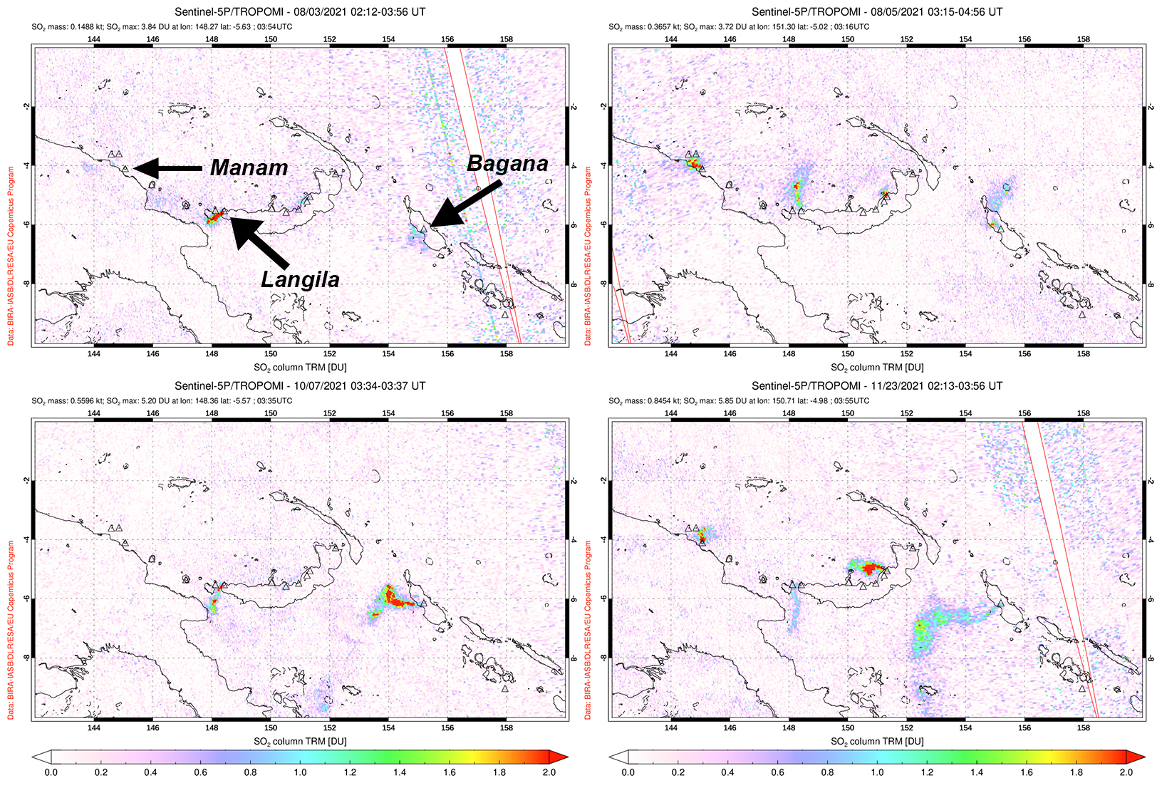 |
Figure 27. Small sulfur dioxide plumes were visible above Langila based on data from the TROPOMI instrument on the Sentinel-5P satellite. Plumes drifted SW on 3 August (top left), NW on 5 August (top right), SW on 7 October (bottom left), and S on 23 November (bottom right) 2021. Plumes were also intermittently visible from Manam (to the W) and Bagana (to the E). Courtesy of the NASA Global Sulfur Dioxide Monitoring Page. |
Geological Summary. Langila, one of the most active volcanoes of New Britain, consists of a group of four small overlapping composite basaltic-andesitic cones on the lower E flank of the extinct Talawe volcano in the Cape Gloucester area of NW New Britain. A rectangular, 2.5-km-long crater is breached widely to the SE; Langila was constructed NE of the breached crater of Talawe. An extensive lava field reaches the coast on the N and NE sides of Langila. Frequent mild-to-moderate explosive eruptions, sometimes accompanied by lava flows, have been recorded since the 19th century from three active craters at the summit. The youngest and smallest crater (no. 3 crater) was formed in 1960 and has a diameter of 150 m.
Information Contacts: Darwin Volcanic Ash Advisory Centre (VAAC), Bureau of Meteorology, Northern Territory Regional Office, PO Box 40050, Casuarina, NT 0811, Australia (URL: http://www.bom.gov.au/info/vaac/); MIROVA (Middle InfraRed Observation of Volcanic Activity), a collaborative project between the Universities of Turin and Florence (Italy) supported by the Centre for Volcanic Risk of the Italian Civil Protection Department (URL: http://www.mirovaweb.it/); Hawai'i Institute of Geophysics and Planetology (HIGP) - MODVOLC Thermal Alerts System, School of Ocean and Earth Science and Technology (SOEST), Univ. of Hawai'i, 2525 Correa Road, Honolulu, HI 96822, USA (URL: http://modis.higp.hawaii.edu/); NASA Global Sulfur Dioxide Monitoring Page, Atmospheric Chemistry and Dynamics Laboratory, NASA Goddard Space Flight Center (NASA/GSFC), 8800 Greenbelt Road, Goddard, Maryland, USA (URL: https://so2.gsfc.nasa.gov/); Sentinel Hub Playground (URL: https://www.sentinel-hub.com/explore/sentinel-playground).