Report on La Palma (Spain) — February 2022
Bulletin of the Global Volcanism Network, vol. 47, no. 2 (February 2022)
Managing Editor: Edward Venzke.
Edited by Kadie L. Bennis.
La Palma (Spain) Phreatomagmatic and Strombolian activity, lava effusion, and ash plumes through mid-December 2021
Please cite this report as:
Global Volcanism Program, 2022. Report on La Palma (Spain) (Bennis, K.L., and Venzke, E., eds.). Bulletin of the Global Volcanism Network, 47:2. Smithsonian Institution. https://doi.org/10.5479/si.GVP.BGVN202202-383010
La Palma
Spain
28.57°N, 17.83°W; summit elev. 2426 m
All times are local (unless otherwise noted)
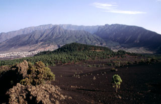
La Palma is a 47-km-long island at the northwestern end of the Canary Islands. It is composed of two large volcanic centers, with the younger Cumbre Vieja to the south dating back 125,000 years. Multiple eruptions during the last 7,000 years have produced mild explosive activity and lava flows which have damaged populated areas and reached the sea in 1585, 1646, 1712, 1949, and 1971. A new eruption from the SW flank began on 19 September 2021, roughly 20 km NW of the site of the 1971 eruption. Two fissures opened and multiple vents produced lava fountains, flows, and ash plumes; the flows traveled over 5 km to the W toward the coastline, eventually extending further into the ocean, damaging buildings and crops (BGVN 46:10). Information in this report describing lava fountains, flows, and ash plumes through the end of the eruption comes from Spain’s Instituto Geographico Nacional (IGN), the Instituto Volcanologico de Canarias (INVOLCAN), the Steering Committee of the Special Plan for Civil Protection and Attention to Emergencies due to Volcanic Risk (PEVOLCA), maps from Copernicus EMS, satellite data, and news and social media reports covering October through December 2021.
Summary of activity during October-December 2021. Strong eruptive activity that began on 19 September continued throughout most of this reporting period. During October, more than 3,000 earthquakes were detected in the southern part of the island and ash plumes rose as high as 5.5 km altitude, according to the Toulouse VAAC. Lava flows emerged from two new vents and moved W toward the coastline, affecting 3,063 buildings, of which 2,896 were destroyed. (figure 31). The lava flow field continued to expand through the eruption (table 2). There were a total of 11 flows numbered during this reporting period. Flow 2, located between the main flow (Flow 1), had reached the sea on 21 September. Lava, including bombs, were ejected as far as 800 m from the vent. Lava fountains rose hundreds of meters high and collapses of the crater walls were common. Similar activity was reported in November, with frequent earthquakes, ash plumes that rose to 4.6 km altitude, ejecta, and multiple lava effusions, some of which reached the coastline and formed a lava delta. Several thousand people were evacuated. During December, the number of earthquakes detected, and ash plumes was notably lower. An ash plume on 13 December rose as high as 7.5 km altitude, but overall, they were lower compared to the previous months. Strong lava effusion persisted during the first half of the month, some of which continued to feed the lava deltas on the coast. By mid-December, activity had mostly subsided, with only some incandescence, weak lava flows, and low gas-and-ash plumes. Sulfur dioxide emissions were consistently detected until mid-December.
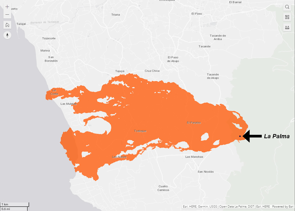 |
Figure 31. Simplified location map showing the lava flows generated from the La Palma eruption taken from drone data on 15 December 2021. The black dot represents the vent, and the orange area is the lava coverage that moved generally W. The names of the affected nearby towns are also included. Courtesy of Dirección General de Tráfico. |
Table 2. Summary of the growth of the lava flow field at La Palma between October and December 2021, listing the width of the field (m) and the covered area (km2). Area values were rounded up to the nearest tenth. Data courtesy of PEVOLCA.
| Date | Width (m) | Area (km2) |
| 04 Oct 2021 | 1,250 | 4.1 |
| 08 Oct 2021 | 1,250 | 4.7 |
| 10 Oct 2021 | 1,520 | 5.3 |
| 11 Oct 2021 | 1,520 | 5.9 |
| 12 Oct 2021 | -- | 6.1 |
| 13 Oct 2021 | 1,770 | 6.4 |
| 16 Oct 2021 | 2,350 | 7.2 |
| 17 Oct 2021 | 2,350 | 7.4 |
| 19 Oct 2021 | 2,900 | 7.8 |
| 20 Oct 2021 | 2,900 | 8.0 |
| 22 Oct 2021 | 2,900 | 8.5 |
| 26 Oct 2021 | -- | 8.8 |
| 03 Nov 2021 | 3,100 | 9.8 |
| 09 Nov 2021 | 3,100 | 9.9 |
| 11 Nov 2021 | 3,100 | 10.1 |
| 13 Nov 2021 | 3,100 | 10.2 |
| 16 Nov 2021 | 3,200 | 10.3 |
| 23 Nov 2021 | 3,300 | 10.7 |
| 24 Nov 2021 | 3,300 | 10.9 |
| 25 Nov 2021 | 3,350 | 11.0 |
| 27 Nov 2021 | -- | 11.5 |
| 30 Nov 2021 | 3,350 | 11.3 |
| 02 Dec 2021 | 3,350 | 11.4 |
| 05 Dec 2021 | 3,350 | 11.6 |
| 07 Dec 2021 | 3,350 | 11.8 |
| 14 Dec 2021 | 3,350 | 12.0 |
| 25 Dec 2021 | -- | 12.2 |
Activity during October 2021. Frequent earthquakes were detected during October (a total of 3,416 on the island of La Palma), 635 of which were felt by the nearby communities; most were located 10-15 km deep in the SE area of the island where the swarm had initiated in early September, though some were recorded at depths greater than 30 km (figure 32). The strongest events, magnitude 5.0, occurred on 30 and 31 October at depths of 35 and 38 km, respectively.
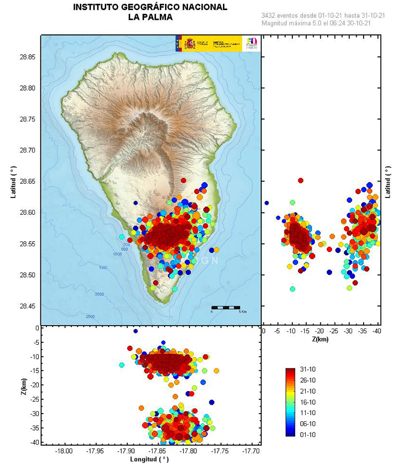 |
Figure 32. Map of seismic events at La Palma showing the location of earthquakes on the SE part of the island during 1-31 October 2021, which remained in the same location as those detected on 11 September 2021. The depths of these events range up to 40 km. The color bar on the right represents the dates of the seismic events beginning on 1 October. Courtesy of IGN (Actualización de la información sobre la actividad volcánica en el sur de la isla de La Palma). |
The Toulouse VAAC issued 320 volcanic ash advisories (VAA) for aviation during the reporting period, based on data from satellite imagery and webcams. During October, 132 VAAs described ongoing ash emissions that reached 1.8-5.5 km altitude and drifted up to 185 km in different directions. Some ashfall deposits were reported near the volcano.
By 1 October, roughly 80 million cubic meters of lava had been erupted. Two vents opened about 600 m NW from the main cone on 1 October, forming small cones within two days. Lava from these vents traveled W, then connected with the main flow field downslope. Explosions ejected centimeter-sized material as far as 3.3 km from the cone, and ash and lapilli deposits were reported in areas downwind. The lava flow had extended 540 m beyond the original coastline. Based on satellite images from Copernicus, more than 1,000 buildings had been destroyed in El Pason, Los Llanos de Aridane, and Tazacorte. Ash plumes rose to 3-5 km altitude and drifted S on 2 October.
By 3 October the width of the lava flow field was a maximum of 1,250 m and lava tubes were identified in satellite images. The lava flow had developed four lobes that were fed by multiple lava flows and had an estimated area of 4.1 km2. In the afternoon, the frequency and intensity of the explosions ejected bombs as far as 800 m. Lava fountains rose hundreds of meters high. During 1900-1945 one of the new cones collapsed and spilled into the inner lava lake; lava flows traveled downslope carrying blocks from the destroyed parts of the cone. By 5 October the volume of erupted lava was estimated to be 35 million cubic meters, according to INVOLCAN.
On 6 October a breakout lava flow from the W end of the main flow field traveled S between Los Guirres and El Charcó, destroying crops and buildings (figure 33). On 8 October a new vent had formed on the main cone as ash plumes rose as high as 3.5 km altitude and lightning was occasionally visible; ash deposits at the La Palma and Tenerife North (on Tenerife Island) airports caused a temporary shutdown. The N part of the cone collapsed on 9 October, generating a wide, multi-lobed flow carrying larger blocks NW over older flows (figure 34), based on a news article from Europe Press. The flow quickly advanced to the W along the N margins of the flow field, causing more damage in Todoque and an industrial area.
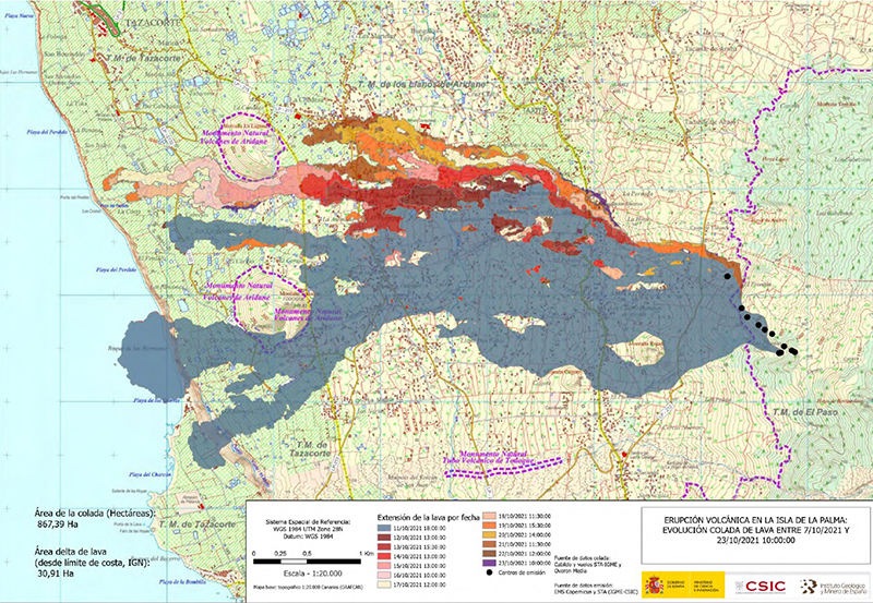 |
Figure 33. The map of the active lava flows at La Palma between 7 October and 1000 on 23 October 2021. The total area covered by the flows is 8.7 km2 while the lava delta on the W coast is 0.3 km2. The black dots (right) represent the emission vents. The color scale dates the occurrence of the flow. The gray main part of the flow was updated on 11 October 2021 at 1800. Other flow dates ranged from 12-23 October 2021. A partial collapse of the NW flank on the main cone sent large blocks downslope, causing lava to spill out into numerous flows on 23 October. Generally, the direction of travel is to the W toward the coastline. Courtesy of Copernicus EMS, PEVOLCA, CSIC, and IGME. |
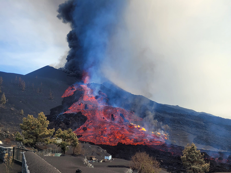 |
Figure 34. Photo of a lava flow originating from the N base of the main cone at La Palma on 9 October 2021. Courtesy of Raúl Pérez, IGME. |
By 10 October there had been about 6,000 people evacuated, between 726 and 1,323 buildings damaged by lava, and more than 1.3 km2 of crops destroyed. The inner crater lava lake spilled out after part of the cone had collapsed, which fed more flows and floated large, cooled blocks downslope. According to PEVOLCA, the main flow runs W and NW toward the ocean to as far as 300 m (figure 35). Ash plumes rose to 3.5-4 km altitude and caused ashfall to the S. Video showed lava fountains rising 500 m above the vent late that night.
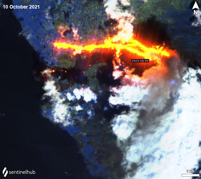 |
Figure 35. Sentinel-2 infrared satellite images showing the main lava flow moving W and NW toward the coastline from La Palma on 10 October 2021. A gray ash plume is drifting SW. Image with “Atmospheric penetration” rendering (bands 12, 11, 8a). Courtesy of Sentinel Hub Playground. |
The lava field grew to the N and S on 11 October and was an estimated 5.91 km2 with a width of 1,520 m, though the flows that had fed it slowed. The northernmost flow advanced another 50 m toward the coast. On 12 October this N lava flow prompted an evacuation of roughly 700-800 people from the La Laguna area; it continued to move over crops and was 200 m from the coast.
The main cone had at least three effusive vents and another vent to the N was also active. Multiple collapses of parts of the cone sometimes sent large blocks of cooler lava rafting down the flows and the lava field was fed by numerous streams of lava. The lava flow field included three areas: the initial main flow that traveled W around the S part of Mantaña de Todoque toward the ocean; a flow that had branched off of the main flow to the S; and flows that traveled W along the N margins of the main flow. The main and S lava flows were being only minimally fed.
As intermittent ash plumes continued, INVOLCAN reported that ash and tephra deposits (figure 36) had grown to a volume of 8-9 million cubic meters since the start of the eruption through 13 October. On the night of 13 October and the morning of 14 October, 400 people were evacuated from La Laguna in Los Llanos de Aridane as the N flow advanced NW. More than 100 million cubic meters of lava had been erupted since the beginning of the eruption, according to PEVOLCA. During 13-19 October the lava flows along the N margins (the N flow) were the most active and were comprised of two main branches.
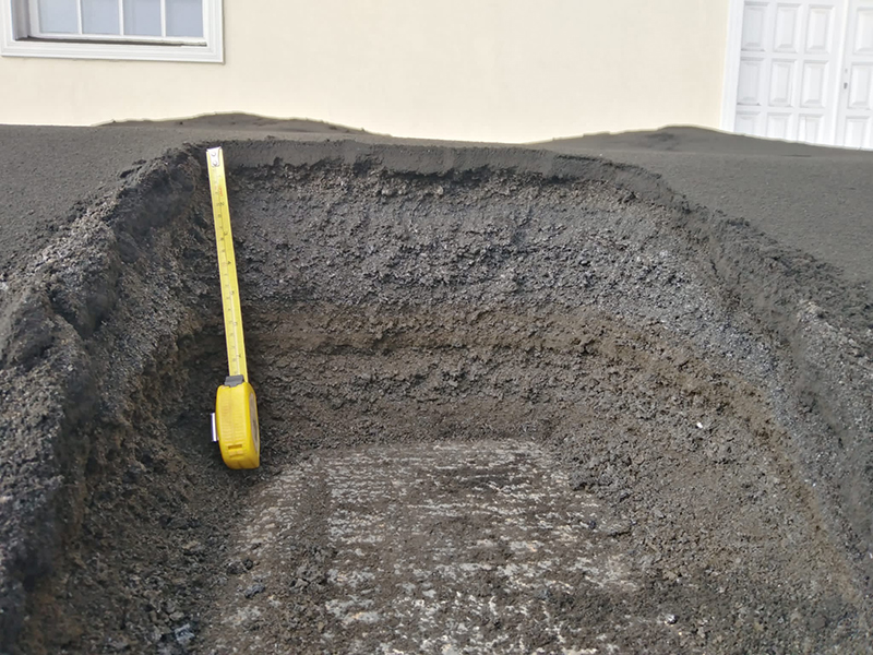 |
Figure 36. Photo of tephra deposits from La Palma taken on 13 October. The volume of tephra is estimated to be 8-9 million cubic meters since the start of the eruption. Courtesy of INVOLCAN. |
A vent located 300 m from the SE base of the main cone reactivated during 15-16 October, which generated some phreatomagmatic activity and gas-and-ash emissions. At the same time, increased phreatomagmatic activity was detected in the main vent. Ongoing lava fountains during 16-17 October were reported by the Toulouse VAAC, based on webcam images (figure 37). Large blocks were carried downslope by the advancing N flows, which would occasionally overflow their channels and spread laterally for short distances. The flow reached Montaña de La Laguna, traveled around the S part, and continued to the W toward the ocean; by 19 October the end of the lava flow was 100-110 m from the coastline. Small avalanches in areas with thick ash deposits descended slopes near the Tamanca ravine, producing small ash plumes.
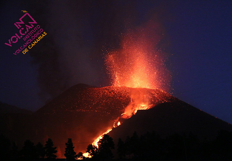 |
Figure 37. Photo of Strombolian activity at La Palma taken at 2000 on 17 October 2021. Courtesy of INVOLCAN. |
On 19 October around 0900 an ash plume reported by IGN rose to 5 km altitude. The lava flow that moved through the N of Mantaña Todoque had stopped that day, while the one advancing through the S of La Laguna was 130 m from the coastline. By this time, about 6,400 people had been evacuated. A new vent that opened in the area between the main cone and the 16 October vent (300 m from the SE base of the main cone) exhibited explosive phreatomagmatic activity followed by Strombolian activity.
On 20 October an ash plume rose to 3.5 km altitude. The main cone varied in shape as partial crater rim and wall collapses occurred and the eruption progressed. The main cone generated explosions and a lava overflow, which was visible at 2000 on 22 October. During 22-23 October there was a decrease in the rate of advancement. A partial collapse of the NW flank on the main cone intensified ash emissions and sent large blocks downslope on 23 October; these blocks fell onto another vent which caused lava to spill out into numerous flows (figure 33). Strong explosions heard at 1230 ejected material out of the vent, and lava overflowed a vent on the flanks of the main cone at 1415. Ash emissions rose to 3 km altitude.
Tall lava fountains rose from at least two vents on 24 October. A new vent opened on the NW flank in the afternoon and effused lava at a high rate. As a result, the vent increased in height and width during 24-25 October. The vent located at the SE end of the fissure produced slow-moving lava flows that traveled to the SW. By this time, a total of nine emission points had emerged since the start of the eruption, though only four remained active: the main flow runs along the N margins, covering previous flows; one flow originated from the SE end of a fissure, moving SW; and one flow emerged on the NW slope of the main cone. This NW flow generated large blocks that fell on a lower lava emission point that resulted in multiple lava spills. Ash plumes rose to 3.8 km altitude. More than 50 km of roads had been damaged, along with roughly 2,270 buildings (2,143 destroyed) and 2.6 km2 of crops affected, according to a Copernicus EMS map.
On 25 October strong explosive activity was visible; a small collapse of the cone was observed at 1700. Between 2000-2100 a lava lake in the main cone increased in volume, resulting in a partial collapse of the upper part of the cone and producing large, detached blocks that rafted downslope on several lava flows. Lava advanced over some areas that were previously unaffected, particularly in Alcalá, covering 8.79 km2 by 26 October. Flows on the N end of the field were less than 100 m from the coastline. Lava fountains rose as high as 600 m from the vent located at the SE end of the fissure.
When the flow reached the coastline, a delta formed, reaching 120 m water depth while rock fragments from the end of the flow were observed at depths of 360 m. Lava filled the upper and middle areas of underwater ravines, covering an area of about 0.11 km2 and with a depth of 10-30 m.
Around noon on 29 October, a series of intense and audible explosions occurred for several hours, generating a large amount of ash that affected the entire W and NW parts of the island. Multiple air quality alerts were issued by authorities as they warned residents of some affected areas (Los Llanos de Aridane in particular) to stay indoors and, if going outside, to wear a filtering mask. On 31 October some larger explosions were accompanied by shock waves, while the effusion rate at the NW flank vent notably increased. An ash plume that day rose at least 4.5 km altitude (figure 38).
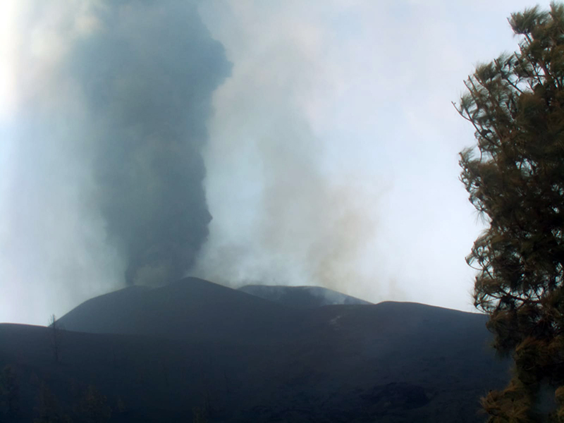 |
Figure 38. Webcam image of an ash plume rising from the main cone at La Palma on 31 October 2021 taken from the Cabeza de Vaca runway. Courtesy of IGN (Actualización de la información sobre la actividad volcánica en el sur de la isla de La Palma). |
Frequent sulfur dioxide plumes with fluxes between 2,882 and 53,600 tons/day were also identified in satellite images drifting as far as 240 km S, as well as in multiple directions (figure 39). The higher value was recorded on 24 October. On 8 October these plumes reached the Caribbean and on 12 October they were over northern Africa, Spain, and Portugal. By 19 October the plumes had extended to the NW over Spain, France, and Germany.
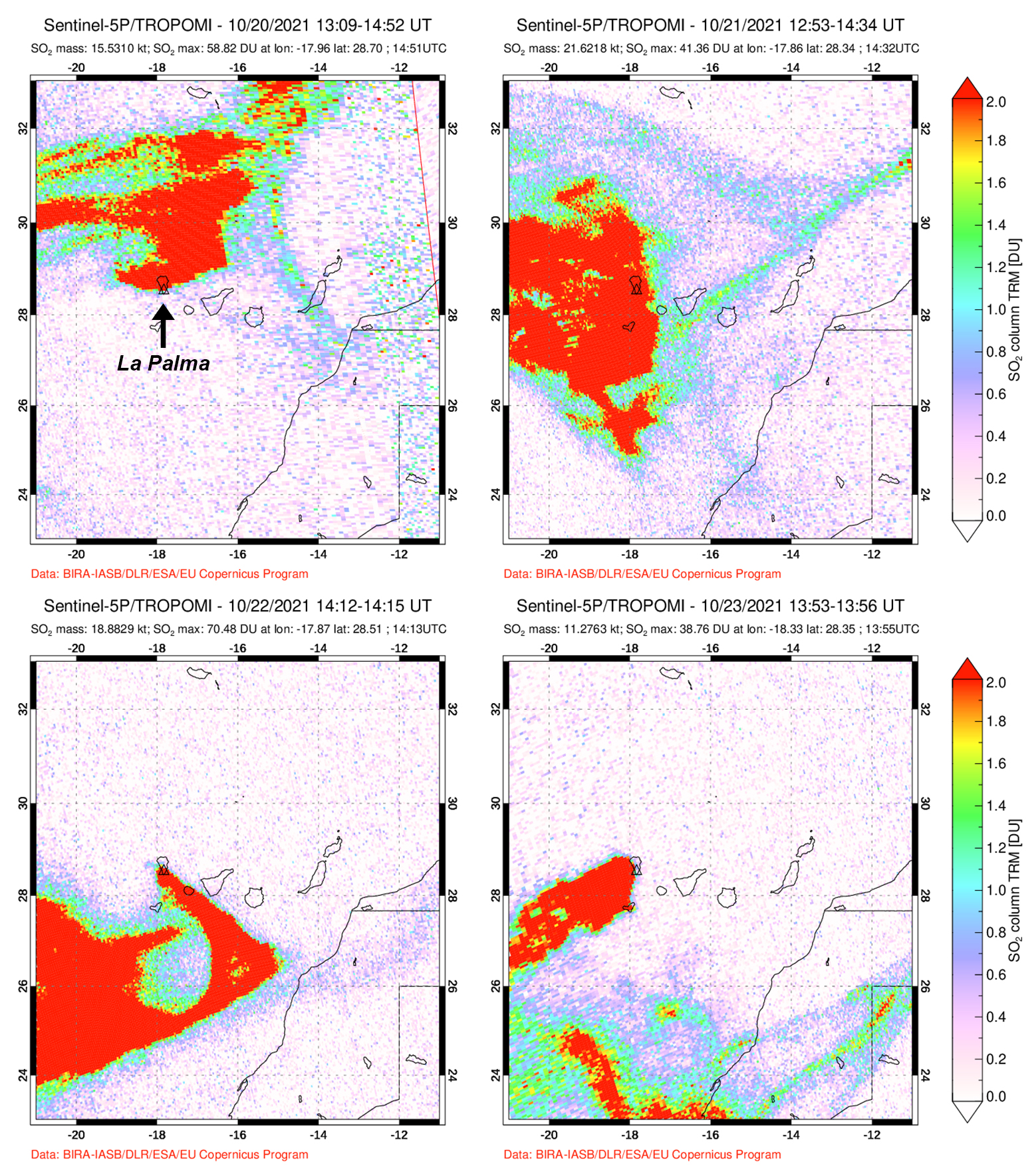 |
Figure 39. Significant sulfur dioxide emissions from the Cumbre Vieja eruption at La Palma were measured by the TROPOMI instrument on the Sentinel-5P satellite. These plumes drifted in multiple directions, reaching as far as the Caribbean on 8 October, northern Africa, Spain, and Portugal on 12 October, and France and Germany by 19 October. The dates shown were taken consecutively during 20-23 October 2021. Courtesy of NASA Global Sulfur Dioxide Monitoring Page. |
Activity during November 2021. During November, frequent earthquakes continued (a total of 2,871 on the island of La Palma), 235 of which were felt by the nearby populations. The maximum magnitude reached 5.1 on 19 November at a depth of 36 km. Seismicity was distributed in two groups: earthquakes that occurred at 10-15 km deep and those at depths greater than 30 km. Volcanic tremor levels decreased around noon on 2 November and again during 4-5 November and remained at low levels through 9 November.
Ash emissions rose to 2.1-4.6 altitude and drifted 55 km N, E, SE, S, SW, and NW. On 3 November explosive activity increased around 1300, producing a dark ash plume that rose to 4.5 km altitude. Intermittent sulfur dioxide emissions continued to be visible in satellite images.
The vents in the main cone continued to effuse lava, eject tephra, and intermittently produce dense and billowing ash-and-gas plumes. Audible explosions and significant ash emissions continued intermittently through 2 November, with ashfall affecting the entire W and NW parts of the island. Lava continued to effuse to the NW from a vent on the NW flank, overflowing and occasionally breaking out and forming new flows. A flow at the end of October originated along the upper central part of the S margin of the flow field, N of Montaña Cogote and on 6 November the rate of advancement increased.
On 5 November the ash plume rose to 3.5 km altitude at 0845 (figure 40). Based on data from the FLIR (Forward Looking InfraRed Infrared) thermal instrument, the temperature of the plume was 178 °C. On 7 November a dense, gray ash plume was reported to 2.7 km altitude that drifted WSW, accompanied by lava fountaining (figure 41).
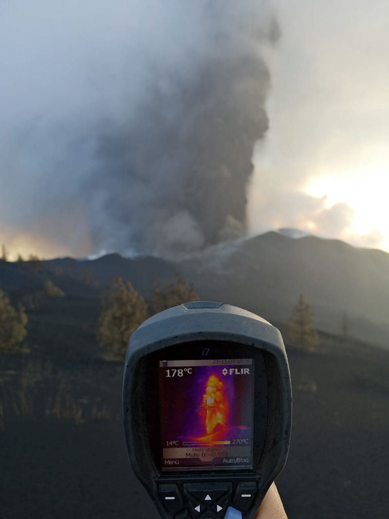 |
Figure 40. Photo of an ash plume rising 3.2 km altitude above La Palma on 4 November 2021, accompanied by a thermal image. The temperature of the plume is 178°C according to the display shown on the FLIR (Forward Looking InfraRed Infrared) instrument being held by a volcanologist. Courtesy of IGN (Actualización de la información sobre la actividad volcánica en el sur de la isla de La Palma). |
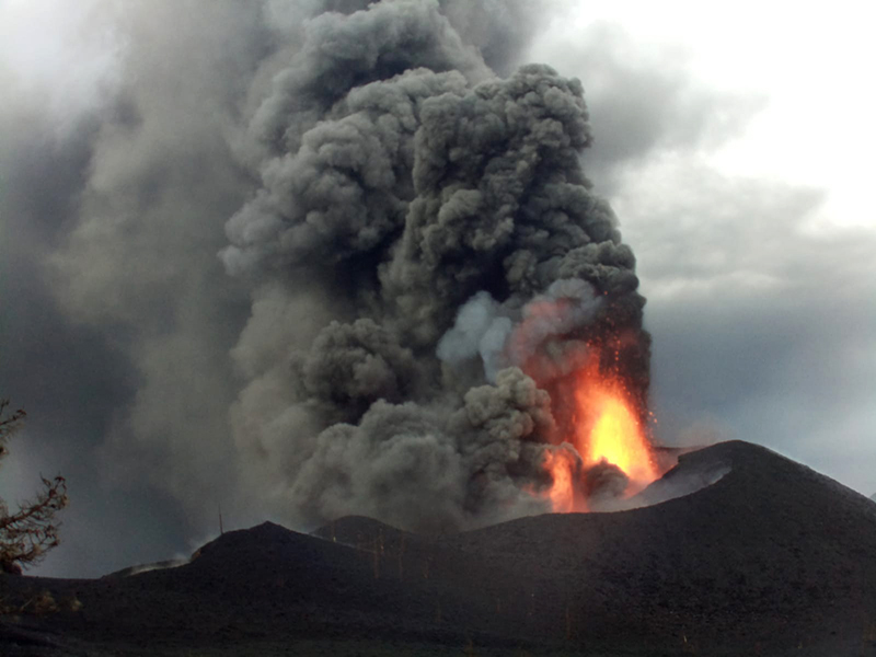 |
Figure 41. Photo of a dense gray ash plume rising above La Palma on 7 November that drifted WSW, accompanied by lava fountaining. Courtesy of IGN (Actualización de la información sobre la actividad volcánica en el sur de la isla de La Palma). |
Flow 2 reached the sea cliff at Los Guirres Beach and entered the sea at 0245 on 9 November (figure 42). A new branch to the N was reported during the morning of 9 November, which was located a few meters from the coastline. On that same day, there was a decrease in seismicity, tremor, and deformation levels, in addition to sulfur dioxide emissions, though scientists were unable to confirm this decline. By 10 November the highest point of the main cone was 1,130 m altitude. Lava continued to flow W through pre-existing lava channels and tubes, over older flows, and occasionally formed new branches. Occasional short-lived lava ponds occurred at the main crater vents. Flow 2 had reached the sea around 0144 on 10 October, starting a new lava delta, which overlapped the previous one to the N. Flows 1-9 continued to advance, while the others remained relatively stationary. Lava filled in some gaps between the N flows (Flows 4 and 7), though flow advancement was mainly focused at and near the ocean entries, feeding flows 1, 2, and 9.
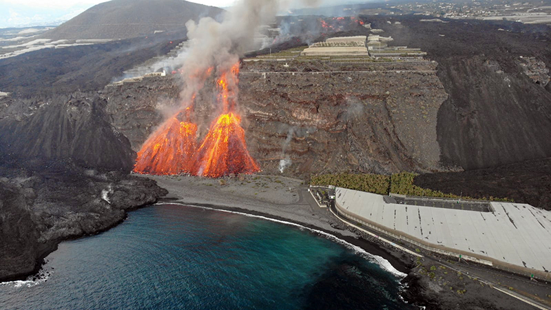 |
Figure 42. Photo of the lava flow from La Palma reaching the sea cliff at Los Guirres Beach and entering the sea at 0245 on 9 November 2021. Courtesy of PEVOLCA. |
A lava lake overflow occurred at the top of the W part of the main cone and lasted for a few hours; the lava flow field covered 10.1 km2. On 13 November, three lava flows continued to feed Flow 1, and to a lesser extent Flows 2 and 9, which in turn fed the lava deltas along the Los Guirres Beach (figure 43). An ash plume at 0845 rose to 3.1 km altitude and drifted SW. Ash emissions intensified on 14 November.
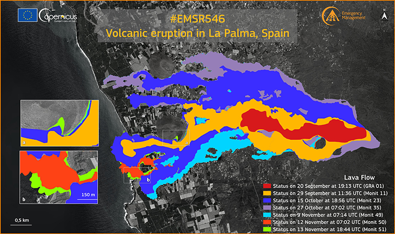 |
Figure 43. The growth of the lava flow field at La Palma during 20 September through 13 November 2021 shown in different colors. The extent of the field on 20 September is shown in red, and on 29 September is shown in orange. In October, the extent on the 15th is shown in blue, with flow coverage on the 27th in purple (on the N side). By 9 November flows shown in light blue had expanded on the S side of the field. Flows moving W towards the coast flows are shown in dark orange on 12 November and in light green on the 13th, where two lava deltas had formed. Courtesy of Copernicus EMS. |
According to IGME, by 15 November the two S lava deltas have merged, covering an area of 0.4 km2 beyond the previous coastline. Flow 9 had reached the sea, feeding the lava deltas along with Flows 1 and 2. Another lava delta grew along Charcón Beach, but its flow was not strongly fed and reached 30 m thick in some areas. The lava flows that had advanced W along the S side of Montaña de La Laguna were 86 m from the coast of Tazacorte, near the beach of El Perdido. On 16 November ash drifted W and SW and caused some flight disruptions at the La Palma airport. Volcanic tremor levels increased during 16-17 November then returned to low levels.
PEVOLCA reported that though Strombolian activity and phreatomagmatic pulses continued, there was an overall decline in activity beginning in mid-November. During 17-18 November Flow 5 advanced along the N base of Montaña de Todoque and along the S edge of Flow 4, which had also advanced and widened (figure 44). After a lull in activity on 17 November, Strombolian activity and ash emissions resumed later in the day, ejecting larger pyroclasts from the vents in the upper part of the cone. On 18 November an ash plume rose to 3.5 km altitude and drifted SW (figure 45). Video data that was posted at 1615 on 18 November showed jetting lava and billowing ash plumes containing some lightning flashes. A PEVOLCA report from 20 November reported that the total volume of emitted tephra during the eruption was more than 10 million cubic meters.
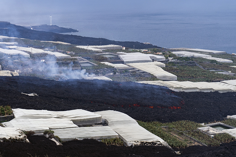 |
Figure 44. Photo of lava flows from La Palma covering new areas between the Montaña de Todoque and La Laguna during 17-18 November 2021. Courtesy of PEVOLCA. |
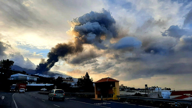 |
Figure 45. Photo of an ash plume rising to 3.5 km altitude and drifting SW from La Palma on 18 November 2021. Courtesy of IGN (Actualización de la información sobre la actividad volcánica en el sur de la isla de La Palma). |
Around 2000 on 19 November increase in the effusion rate caused the lava lake to overflow. Three flows were active: Flow 11 ran from Montaña Rajada to the N of Montaña Cogote, one fed the lava deltas off the coast, and the third was located to the NW between Flows 4 and 7 (figure 46). During the evening, lava overflowed one of the craters in the main cone; crater overflows were again visible on 21 November. Lava continued to fill in gaps between Flows 4 and 7 and by 21 November, the two had merged. Flow 7 advanced W and by 1303 on 22 November, reaching the sea at La Viña Beach (figure 47). The lava delta had an area of approximately 0.43 km2.
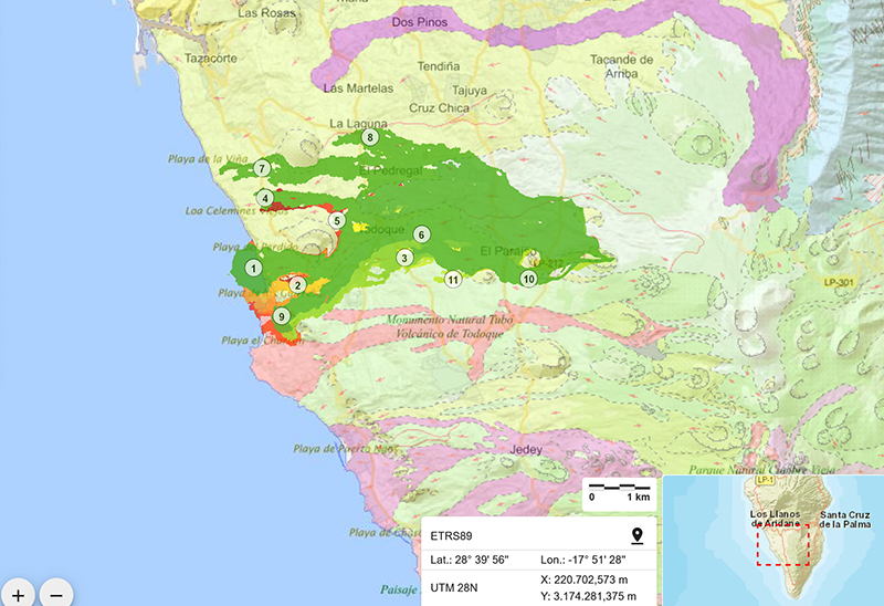 |
Figure 46. Map of lava flows 1-11 effusing from La Palma moving generally W toward the coastline on 19 November 2021. Flows 1, 2, and 9 supplied the lava delta S of Flows 4 and 7. Green represents older flows while red represents younger flows. The pink and purple regions denote part of IGME’s Continuous digital geological mapping. Courtesy of IGME. |
 |
Figure 47. Map of Flow 7 from La Palma arriving at the sea at La Viña Beach on 22 November 2021. Flows 4 and 5 are located to the S of Flow 7 and the front of Flow 8 is to the E of it. Courtesy of PEVOLCA. |
By 23 November, Flows 1, 2, and 9 had merged and fed the main S delta, which extended 0.41 km2 from the coastline. Roughly 7,500 people had been affected by evacuations across El Paso, Fuencaliente, Los Llanos de Aridane, Tazacorte, and Villa de Mazo. During 23-25 November, Flows 4, 5, and 7 at the N end of the flow field continued to widen and advance, filling in gaps between previous flows and feeding the N lava delta. Flows 1, 2, and 9 fed the S delta at a lower rate. The N lava delta, fed by Flow 7, was estimated to be 0.05 km2 while the S lava delta was 0.43 km2 by 24 November. An ash plume rose to 4.3 km altitude on 24 November.
The number of active flows on the flow field increased as lava overflowed their channel margins or broke out of the lava tubes. The easternmost vent produced a fast-moving flow that traveled along the S margin of Flow 10 and around the S side of Montaña Cogote on 24 November. The flow advanced through the Las Manchas cemetery and inundated parts of a solar power plant; the newly covered areas were within the exclusion zone, which had already been evacuated. During 24-26 November ash plumes rose as high as 4.8 km altitude and drifted E, which resulted in ashfall at the La Palma airport. The lava effusion rate increased at the main crater vents at 0900 on 25 November, and around 1100 two small E-W fissures opened less than 1 km S of the main cone. The amplitude of the volcanic tremor signal fluctuated at low-medium levels that coincided with the effusive episodes that occurred on 25 November. The flow rate slowed to about 25 m/hour and merged with Flow 11 by 26 November. A lava overflow SW of Flow 3 produced a small branch oriented laterally to the flow margin. Flow 7 widened during 26-27 November as it continued to be fed.
On 28 November new vents opened on the NE flank of the main cone around 0300, accompanied by an ash plume that rose to 1.6 km altitude from the main crater and drifted SW (figure 48). The new vents produced fluid lava flows that traveled N and NW through the Tacande area and were followed by landslides on the NW flank of the cone. According to a video taken at 1145 lava fountains rose from one of the vents, while another ejected tephra. Video footage taken at 1050 on 29 November showed lava flows transporting large blocks downslope while another one showed lava flowing at a rate of about 1 m/s. By noon, the vents in the main cone became noticeably less active and were more intermittent through 30 November. Several lava streams from the new vents continued to advance NW and then W along older flows which had split into two branches on 26 November. One branch traveled through tubes and fed Flows 4, 5, and 7 between Montaña de Todoque and Montaña de La Laguna while the other descended toward Flow 8 (the northernmost flow). According to PEVOLCA, the S lava delta was estimated to be 0.43 km2 while the N lava delta was about 0.06 km2. Roughly 2,860 buildings had been affected by 30 November (2,748 destroyed) and about 3.5 km2 of crops were covered by lava.
 |
Figure 48. Photo of the new vent that opened on the E of the main cone of La Palma on 28 November 2021 (left), accompanied by lava fountaining, a flow, and an ash plume that rose to 1.6 km altitude and drifted SW (right). Courtesy of IGN (Actualización de la información sobre la actividad volcánica en el sur de la isla de La Palma). |
Strong sulfur dioxide plumes fluctuated at a rate of 7,000-43,000 tons/day, but was as low as 900-4,000 tons per day, showing an overall decrease compared to the amount emitted during October. On 5 November photos showed sulfur deposits on the E flank on the main cone and in other areas near vents emitting volcanic gases (figure 49). During 27-28 November there was a brief surge in sulfur dioxide emissions with values of 30,000-49,999 tons/day (figure 50) and remained relatively high during 29-30 November with values between 1,000 and 29,999 tons/day.
 |
Figure 49. Photo showing sulfur deposits (light yellow) on the E flank of the upper part of the cone at La Palma (center background) on 5 November 2021. A gray ash plume is also visible rising above the cone. Courtesy of IGN (Actualización de la información sobre la actividad volcánica en el sur de la isla de La Palma). |
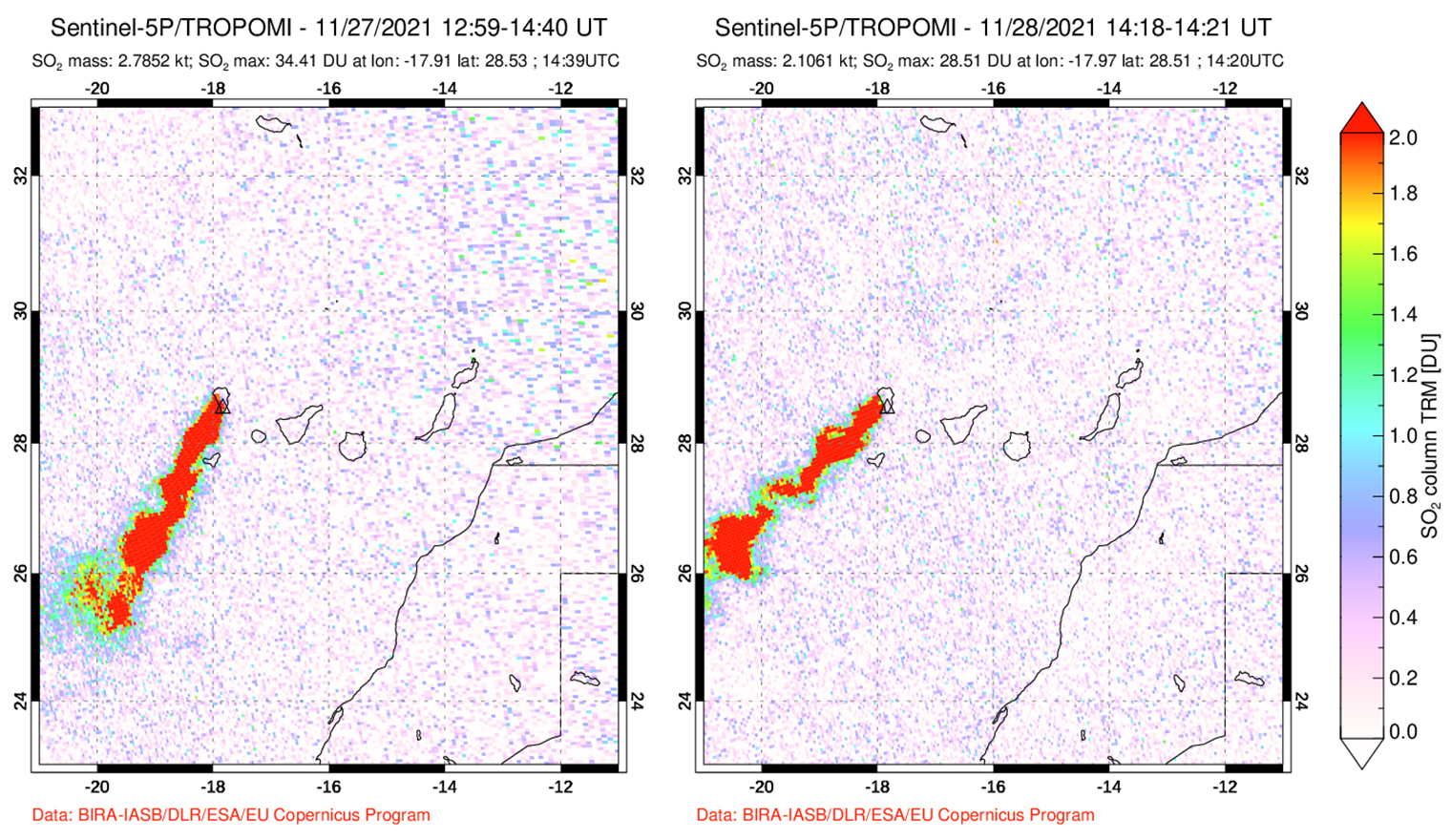 |
Figure 50. Sulfur dioxide emissions from the Cumbre Vieja eruption at La Palma measured by the TROPOMI Instrument on the Sentinel-5P satellite persisted, drifting in different directions. During 27 and 28 November 2021 strong plumes were detected drifting SW. Courtesy of NASA Global Sulfur Dioxide Monitoring Page. |
Activity during December 2021. A total of 1,357 earthquakes were detected during December on the island of La Palma, with a maximum magnitude of 4.2 on 19 December. The nearby population felt 44 of these earthquakes during this month. On 1 December a gas-and-steam plume rose as high as 5.2 km altitude while an ash plume rose to 3.5 km altitude and drifted SSW at 0945.
During December, about 60 VAAC notices were issued, noting that low-to-moderate ash emissions rose to 1.9-3.9 km altitude and drifted SW and S; low sulfur dioxide emissions were also detected in satellite images. On 13 December a strong explosion generated an ash plume that rose as high as 7.5 km altitude. By the next day, ash emissions resumed to low levels of 2.4 km altitude that drifted E and S.
Persistent Strombolian activity was sometimes intense on the NE flank during 1-3 December as lava continued to feed Flow 8 and the N lava delta. Lava fountains rose 400-500 m above the vent on 2 December (figure 51). A new pyroclastic cone had formed around the vent on the NE flank, though it was unstable and blocks from partial collapses descended via lava flows. According to PEVOLCA, a new Flow 12 was the northernmost flow after it split from Flow 8 and traveled over the Fronton area but then later rejoined Flow 8 downslope; Flow 8 was located about 800 m from La Laguna. The flows reached part of the Tacande highway on 3 December. Flow 7 continued to feed the N lava delta. The vents in the main cone were quieter and periodically emitted ash and gas. A N-S oriented crack opened in an area 100 m S of the main vent, which was likely due to subsidence. On 3 December a new fissure opened on the SE flank of the main cone that produced Strombolian activity and fast-moving lava flows that traveled SW along Flow 10. An ash plume rose to 1.9 km altitude and drifted SSW, accompanied by continued lava fountains (figure 52).
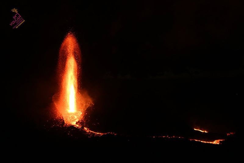 |
Figure 51. Photo of a lava fountain rising 400-500 m above La Palma on the NE flank on 2 December 2021. Courtesy of INVOLCAN. |
 |
Figure 52. Photo of an ash plume rising to 1.9 km altitude and drifted SSW from La Palma on 3 December 2021. Lava fountains were also visible in the photo to the left. Courtesy of IGN (Actualización de la información sobre la actividad volcánica en el sur de la isla de La Palma). |
A flow continued to advance W on 4 December, though at a slower rate as it filled in gaps between Flows 3 and 11. By 4 December the NE vent was quiet. Flows 7, 8, and 10 were fed via lava tubes, though also at a lower rate. Several new vents along an E-W fissure located W of Montaña del Cogote opened around noon on 4 December, producing multiple fast-moving lava flows. The flows descended SW over new land, crossing into Tazacorte and Los Llanos de Aridane, destroying 60 homes. It merged with Flow 9, reaching the sea cliff in the Las Hoyas area by 5 December, descending the cliff the next day. During 6-7 December lava advanced W through multiple tubes and fed Flows 1 and 2, as well as the S delta. A new bathymetry between Flows 1 and 4 showed they occurred at shallow depths of up to 4.5 m. The NE vent resumed with sporadic Strombolian activity and ash emissions. Several vents in the central and SE parts of the main cone also produced sporadic Strombolian activity and ash emissions as well.
During 8-12 December activity at several vents in the central and SE part of the main cone was low, with only sporadic pulses of Strombolian activity and ash emissions. Intense gas emissions were recorded during 9-11 December. Small landslides from fractured areas in the upper part of the secondary cone (on the E flank) descended the interior part of the crater as well as the flanks. Lava from the vents moved through tubes toward the W part of the flow field, though two main breakout flows traveled W over older flows. The most active area was along the S margin of Flow 9, where 9 and 11 had merged, as lava continued to descend the sea cliff and widen the field by Las Hoyas. During 11-12 December lobes from the S margins of the flow traveled S in the Las Norias area (figure 53).
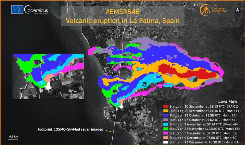 |
Figure 53.The growth of the lava flows at La Palma during 20 September through 11 December 2021 shown in different colors. The extent of the flow on 20 September is shown in red. The extent of the flow on 29 September is shown in yellow. The extent of the flow on 15 October is shown in blue. The extent of the flow on 27 October is shown in purple. The extent of the flow on 9 November is shown in light blue. The extent of the flow on 24 November is shown in light green. The extent of the flow on 5 December is shown in bright pink. The extent of the flow on 9 December is shown in pale pink. The extent of the flow on 11 December is shown in white. Each of these flows are moving W toward the coastline where two lava deltas had formed (N and S). Courtesy of Copernicus EMS. |
On 12 December several strong pulses of tremor were accompanied by intense Strombolian activity. A small lava overflow from one of the vents traveled N over older flows. One of the stronger periods produced dense, dark ash plumes that rose to 6 km altitude and ejected bombs (some of which were several meters in diameter) as far as 500 m from the vent. Collapses enlarged the main crater and the secondary cone on the E flank. During 12-13 December lava continued to travel W through tubes in the central part of the flow field. At the S margins, lava filled in the uncovered areas between Flows 9 and 11. On 13 December tremor levels fluctuated with pulses of intense signals. Strong explosive activity during 1745-1900 ejected bombs toward the N flank and produced gas-and-ash plumes (figure 54). At 1820 video showed lava jetting above the vent and incandescent material falling onto the flanks; activity at the vents decreased after that. Tremor also decreased at 2000 and by 2200 had reached background levels. Gas emissions from the vents were at high levels through 14 December and lava continued to move from the W base of the main cone on 14 December, though at a much lower rate compared to the previous day. Small breakouts were visible near Montaña Cogote and Las Norias. Daily measurements indicated that sulfur dioxide emissions persisted at relatively high levels with values of 1,000-29,999 tons/day (figure 55). According to the Copernicus EMS map, approximately 3,063 buildings had been affected (at least 2,896 destroyed).
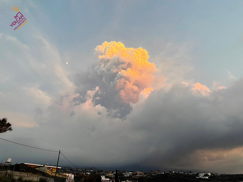 |
Figure 54. Photo of a large gas-and-ash plume rising above La Palma at 1815 on 13 December 2021. Courtesy of INVOLCAN. |
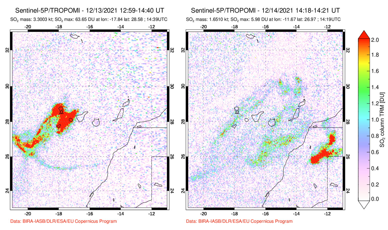 |
Figure 55. Sulfur dioxide emissions from the Cumbre Vieja eruption at La Palma measured by the TROPOMI Instrument on the Sentinel-5P satellite persisted through 13 December 2021. By 14 December the volume of sulfur dioxide emissions notably decreased compared to the continuous emissions from the previous days. Courtesy of NASA Global Sulfur Dioxide Monitoring Page. |
Observations made on 15 December showed no signs of lava flowing from the vents at the W base of the main cone, from tubes, or at the lava delta in the Las Hoyas area. During 15-20 December the tremor was at background levels, and seismicity was very low at all depths. Sporadic gas emissions rose from the vents and from cooling lava flows. Small collapses from the walls of the main and secondary cone craters were visible due to existing faults and fissures. Sulfur dioxide emissions varied from less than 5 to 999 tons/day, which was consistent with a cooling and degassing lava flow field. By the end of December, the number of earthquakes had decreased and were located in the S and E area of the island at shallow depths of 11-16 km and less than 5 km (figure 56). According to PEVOLCA, on 17 December a small lava flow remained active in a lava tube, which was part of Flow 11, running over older flows. Incandescence was observed in the Las Hoyas area.
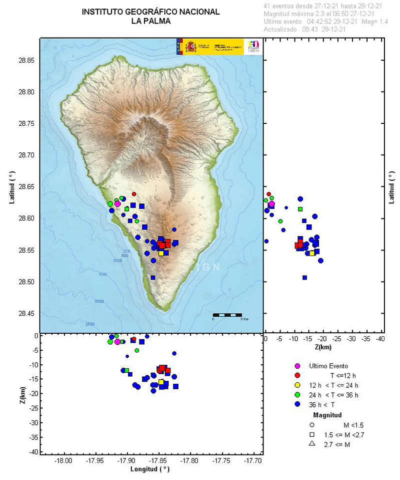 |
Figure 56. Map of the seismic events at La Palma showing the location of earthquakes on the SE part of the island during 27-29 December 2021. The depths of these events were no greater than 16 km. The color bar on the right represents the length each event lasted, while the shape denotes its magnitude. Courtesy of IGN (Actualización de la información sobre la actividad volcánica en el sur de la isla de La Palma). |
On 25 December PEVOLCA announced that the eruption that began at 1511 on 19 September had ended at 2221 on 13 December 2021. During the course of the eruption, six craters were formed and the average length of the cone was 700 m; the largest crater was 172 m by 106 m. The total volume of lava erupted was 200 million cubic meters. Material was ejected as far as 1.5 km over the course of the eruption and lava covered 12.19 km2. The maximum temperature of the lava was 1,140°C. The lava deltas spread 0.48 km2 above the water, while 0.21 km2 was covered underwater.
Geological Summary. The 47-km-long wedge-shaped island of La Palma, the NW-most of the Canary Islands, is composed of two large volcanic centers. The older northern one is cut by the steep-walled Caldera Taburiente, one of several massive collapse scarps produced by edifice failure to the SW. On the south, the younger Cumbre Vieja volcano is one of the most active in the Canaries. The elongated volcano dates back to about 125,000 years ago and is oriented N-S. Eruptions during the past 7,000 years have formed abundant cinder cones and craters along the axis, producing fissure-fed lava flows that descend steeply to the sea. Eruptions recorded since the 15th century have produced mild explosive activity and lava flows that damaged populated areas. The southern tip of the island is mantled by a broad lava field emplaced during the 1677-1678 eruption. Lava flows also reached the sea in 1585, 1646, 1712, 1949, 1971, and 2021.
Information Contacts: Instituto Geographico Nacional (IGN), C/ General Ibáñez de Íbero 3, 28003 Madrid – España, (URL: https://www.ign.es/web/ign/portal, https://www.ign.es/web/resources/volcanologia/html/CA_noticias.html); Instituto Volcanologico de Canarias (INVOLCAN), (URL: https://www.involcan.org/, https://www.facebook.com/INVOLCAN, Twitter: INVOLCAN, @involcan); Toulouse Volcanic Ash Advisory Center (VAAC), Météo-France, 42 Avenue Gaspard Coriolis, F-31057 Toulouse cedex, France (URL: http://www.meteo.fr/aeroweb/info/vaac/); Gobierno de Canarias, (URL: https://www.gobiernodecanarias.org/principal/); Consejo Superior de Investigaciones Científicas (CSIC), Serrano, 117. 28006 Madrid, Spain, (URL: https://www.csic.es/es); El País, SL Miguel Yuste, 40 – 28037 Madrid, (URL: https://elpais.com/sociedad/2021-10-04/fue-como-una-presa-que-se-rompe-la-lava-cubre-ya-413-hectareas-de-la-palma-y-alcanza-un-perimetro-de-36-kilometros.html); Europe Press, Canary Islands, Paseo de la Castellana, 210 28046 Madrid, (URL: https://www.europapress.es/islas-canarias/noticia-registra-nuevo-derrumbe-flanco-norte-volcan-palma-20211009204021.html); El Diario, Gran Vía Street, 46, First Floor 28013 Madrid, (URL: https://www.eldiario.es/canariasahora/lapalmaahora/nuevo-volcan-palma-arrojado-80-millones-metros-cubicos-lava-f_1_8357503.html?fbclid=IwAR3yqzPSVvlIv0ZDol4bRgod3dc31qbn8-SJPQS3MgKvh9MS0pTMj7Yh6B4); Instituto Geológico y Minero de España, Pink Rivers, 23 28003 Madrid, (URL: https://www.igme.es/, https://twitter.com/IGME1849); Dirección General de Tráfico (DGT), Cabildo Insular de la Palma Av. Maritima 3 Santa Cruz de La Palma (URL: https://volcan.lapalma.es/pages/visor); NASA Global Sulfur Dioxide Monitoring Page, Atmospheric Chemistry and Dynamics Laboratory, NASA Goddard Space Flight Center (NASA/GSFC), 8800 Greenbelt Road, Goddard, Maryland, USA (URL: https://so2.gsfc.nasa.gov/); Copernicus EMS (URL: https://emergency.copernicus.eu/, https://twitter.com/CopernicusEMS); Sentinel Hub Playground (URL: https://www.sentinel-hub.com/explore/sentinel-playground).