Report on Ambae (Vanuatu) — March 2022

Bulletin of the Global Volcanism Network, vol. 47, no. 3 (March 2022)
Managing Editor: Benjamin Andrews.
Edited by Kadie L. Bennis.
Ambae (Vanuatu) Explosions on 5 December 2021
Please cite this report as:
Global Volcanism Program, 2022. Report on Ambae (Vanuatu) (Bennis, K.L., and Andrews, B., eds.). Bulletin of the Global Volcanism Network, 47:3. Smithsonian Institution. https://doi.org/10.5479/si.GVP.BGVN202203-257030
Ambae
Vanuatu
15.389°S, 167.835°E; summit elev. 1496 m
All times are local (unless otherwise noted)
Ambae (also known as Aoba) is a large 2,500 km3 basaltic shield volcano located in the New Hebrides arc, part of Vanuatu. Historical eruptions have been recorded since the 16th century, characterized by periodic phreatic and pyroclastic explosions originating from the summit crater lakes. A tuff cone was constructed within Lake Voui (or Vui) during November 2005-February 2006 (BGVN 31:12, figure 30). The most recent eruption occurred from July to September 2018 (BGVN 44:02) consisting of ash plumes, heavy ashfall, and lahars. This report updates activity from June 2019 through December 2021 and describes a new eruption beginning in December 2021 characterized by explosions, a thermal anomaly, and gas-and-steam emissions. Information primarily comes from the Vanuatu Geohazards Observatory of the Vanuatu Meteorology and Geo-Hazards Department (VMGD) and various satellite data.
Activity during June 2019 through November 2021 was relatively low, according to VMGD. On 23 September 2019 the Volcanic Alert Level (VAL) was lowered from 2 to 1 (on a scale of 0-5). Some gas-and-steam emissions were observed in webcam imagery on 4 and 5 May 2021 from a vent in Lake Voui. Intermittent low-strength thermal anomalies were detected by the MIROVA (Middle InfraRed Observation of Volcanic Activity) volcano hotspot detection system based on analysis of MODIS data during May through July 2021 (figure 94). Seven anomalies were detected during May, three during June, four during July, one during early October, and four during December. The December activity was also reflected in Sentinel-2 infrared satellite imagery, which showed a small thermal anomaly in Lake Voui accompanied by a strong gas-and-steam plume that drifted SW (figure 95). On 5 December gas-and-steam emissions rose 250 m high and explosions ejected wet tephra 10 m above the lake surface, based on information from VMGD. As a result, the VAL was raised to 2 on 27 December.
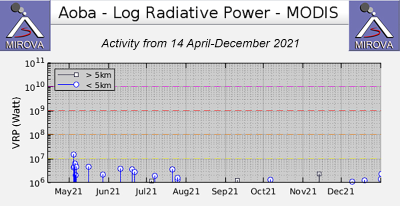 |
Figure 94. Intermittent low-strength thermal anomalies at Ambae were detected in the MIROVA (Log Radiative Power) graph during May through December 2021. Seven anomalies occurred during May, three during June, four during July, one during early October, and four during December. Courtesy of MIROVA. |
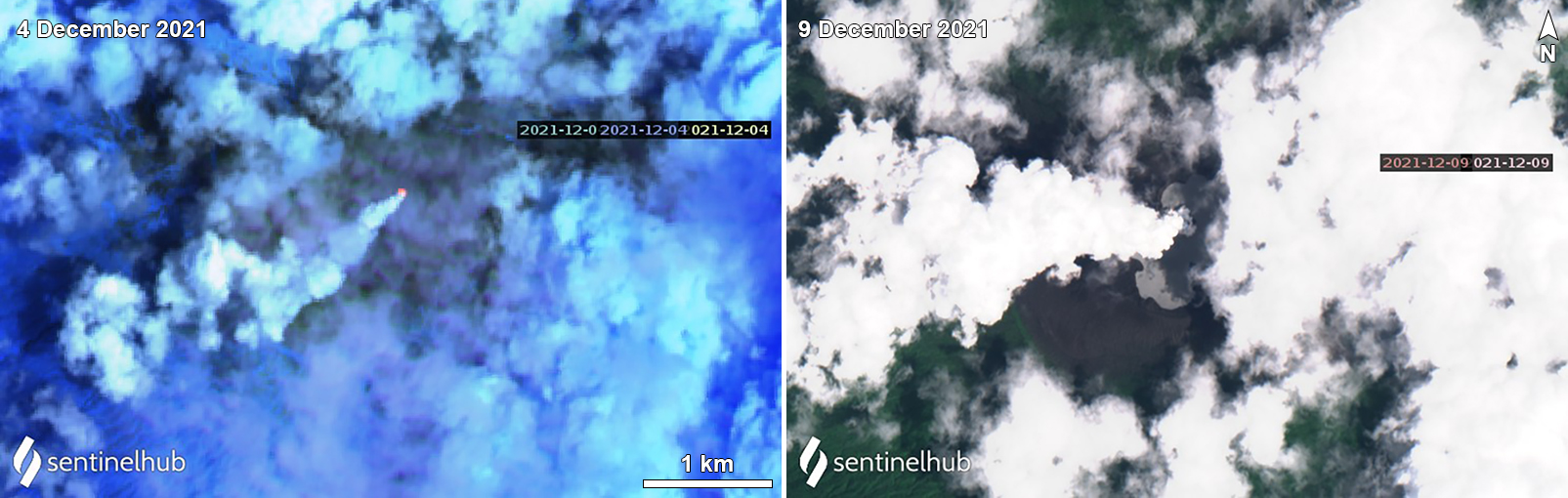 |
Figure 95. Sentinel-2 infrared and natural color satellite imagery showing increased activity at Ambae. On 4 December, a thermal anomaly (bright orange-yellow) was visible and accompanied by a strong gas-and-steam plume that drifted SW (left). On 9 December a notable white gas-and-steam plume drifted W (right). Images using “Atmospheric penetration” (bands 12, 11, 8a) and “Natural Color” rendering (bands 4, 3, 2). Courtesy of Sentinel Hub Playground. |
Geological Summary. The island of Ambae, also known as Aoba, is a massive 2,500 km3 basaltic shield that is the most voluminous volcano of the New Hebrides archipelago. A pronounced NE-SW-trending rift zone with numerous scoria cones gives the 16 x 38 km island an elongated form. A broad pyroclastic cone containing three crater lakes (Manaro Ngoru, Voui, and Manaro Lakua) is located at the summit within the youngest of at least two nested calderas, the largest of which is 6 km in diameter. That large central edifice is also called Manaro Voui or Lombenben volcano. Post-caldera explosive eruptions formed the summit craters about 360 years ago. A tuff cone was constructed within Lake Voui (or Vui) about 60 years later. The latest known flank eruption, about 300 years ago, destroyed the population of the Nduindui area near the western coast.
Information Contacts: Geo-Hazards Division, Vanuatu Meteorology and Geo-Hazards Department (VMGD), Ministry of Climate Change Adaptation, Meteorology, Geo-Hazards, Energy, Environment and Disaster Management, Private Mail Bag 9054, Lini Highway, Port Vila, Vanuatu (URL: http://www.vmgd.gov.vu/, https://www.facebook.com/VanuatuGeohazardsObservatory/); Hawai'i Institute of Geophysics and Planetology (HIGP) - MODVOLC Thermal Alerts System, School of Ocean and Earth Science and Technology (SOEST), Univ. of Hawai'i, 2525 Correa Road, Honolulu, HI 96822, USA (URL: http://modis.higp.hawaii.edu/); MIROVA (Middle InfraRed Observation of Volcanic Activity), a collaborative project between the Universities of Turin and Florence (Italy) supported by the Centre for Volcanic Risk of the Italian Civil Protection Department (URL: http://www.mirovaweb.it/); Sentinel Hub Playground (URL: https://www.sentinel-hub.com/explore/sentinel-playground).