Report on Piton de la Fournaise (France) — April 2022

Bulletin of the Global Volcanism Network, vol. 47, no. 4 (April 2022)
Managing Editor: Edward Venzke.
Research and preparation by Paul Berger.
Piton de la Fournaise (France) Eruption with lava fountains and flow on the S flank, 22 December 2021-17 January 2022
Please cite this report as:
Global Volcanism Program, 2022. Report on Piton de la Fournaise (France) (Venzke, E., ed.). Bulletin of the Global Volcanism Network, 47:4. Smithsonian Institution. https://doi.org/10.5479/si.GVP.BGVN202204-233020
Piton de la Fournaise
France
21.244°S, 55.708°E; summit elev. 2632 m
All times are local (unless otherwise noted)
Short but frequent effusive eruptions have characterized activity at Piton de la Fournaise, the large basaltic shield volcano on Réunion Island in the western Indian Ocean, for several thousand years. Multiple fissure openings, normally within the Enclos Fouqué caldera, have defined recent eruptions, with associated lava fountaining, lava flows, and the development of cones and lava tubes (BGVN 44:11, 46:01). The most recent previous eruption occurred during 9 April-24 May 2021 (BGVN 46:07). This report details a new eruption that began on 22 December 2021 and ended in mid-January 2022. Information is provided by the Observatoire Volcanologique du Piton de la Fournaise (OVPF) and satellite instruments.
The beginning of a new eruption was signaled by a seismic event at 0105 on 22 December, accompanied by rapid deformation beneath the S flank. Volcanic tremor beneath the S part of the caldera began at 0330, signifying the arrival of magma at the surface. OVPF noted that the eruption was preceded by about one month of shallow seismicity, while edifice inflation had been continuous since the end of the previous eruption on 24 May 2021.
Webcam images showed that at least three fissures, then four, opened on the S flank, SE of Piton Kala Pélé and SW of Château Fort (see figure 110 in BGVN 43:03), producing lava fountains and lava flows. The lowest point of the eruption occurred at an elevation of 2,000-2,100 m, more than 500 m below the summit. By the evening, the eruption was focused at 2,030 m elevation where a cone was forming around the vent. The lava effusion rate during 22-23 December, based on satellite data, was an estimated 4-7 m/s, with peak rates of 22 m/s. The cone was 10 m high by 0930 on 23 December, and low lava fountains intermittently rose above the crater rim. Lava flowed from an opening at the base of the cone, though a lava tube was beginning to form; lava had descended 2.2 km SSE from the main vent (figure 215).
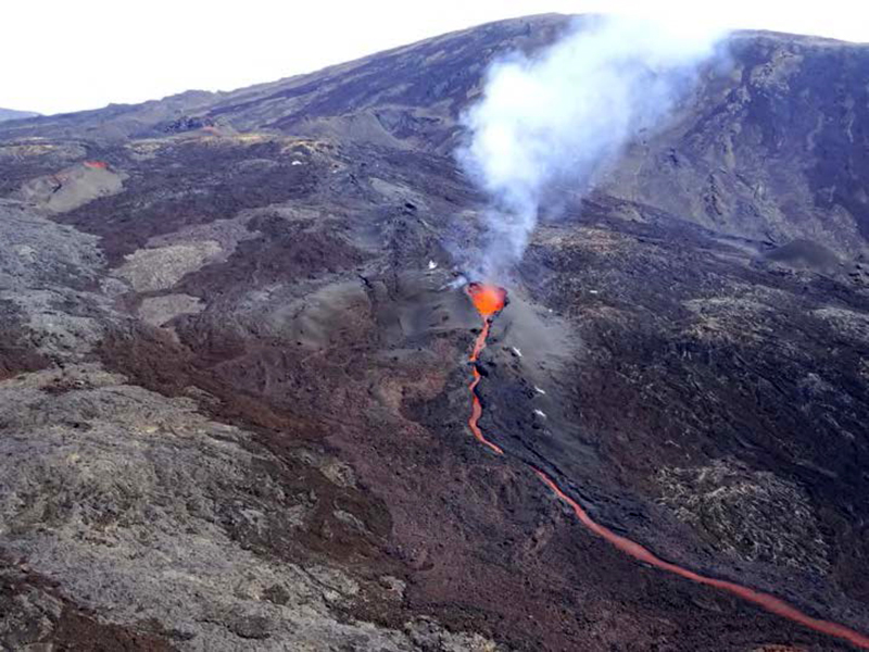 |
Figure 215. Photo showing Piton de la Fournaise’s active cone and lava flow on 23 December 2021 around 0900 local time. By the end of the previous day, activity had concentrated at a single point on the most downstream fissure at about 2,100 m elevation. Courtesy of OVPF. |
During 24-25 December lava traveled from the base of the cone hundreds of meters through a tube before it emerged and advanced in a single channel (figure 216); the lava front had advanced slowly, only traveling an additional 300 m by 25 December (figure 217). During 25-26 December the lava tube broke open and lava was again visible emerging from the base of the cone (figure 218). The flow rate was between 2 and 27 m/s, averaging 5 m/s. A second vent at the base of the cone was visible during the morning of 27 December and lava was again flowing through a tube and emerging downstream. Lava fountaining continued with material occasionally ejected less than 15 m above the cone during 27-28 December. The effusion rate was an estimated 2-8 m/s, based on satellite data. Low lava fountaining, with material rarely rising just above the crater rim, was visible on 29 December. A small mound with a vent that had grown at the base of the main cone was producing gas emissions, and lava advanced through a tube.
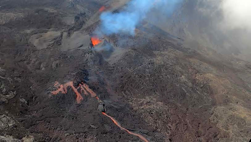 |
Figure 216. Photo of the eruption at Piton de la Fournaise on 24 December 2021 around 1600 local time showing fountaining at the active cone and lava tunnels that extended more than 100 m before the flow emerged as a single channel downstream. Courtesy of OVPF. |
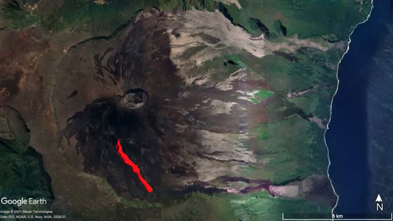 |
Figure 217. Composite map-view image showing the lava flow at Piton de la Fournaise extending SE from the vent around 0830 local time on 24 December 2021. Flow location determined from aerial image processing using stereophotogrammetry on a satellite image base from Google Earth. Courtesy of OVPF. |
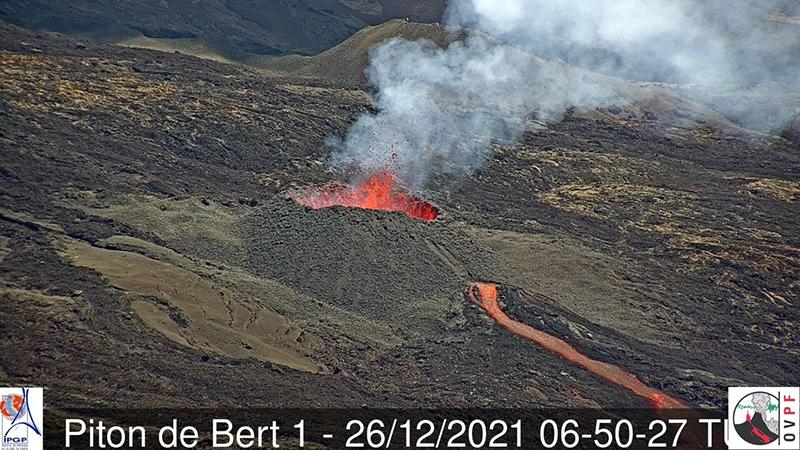 |
Figure 218. Photo of the active vent at Piton de la Fournaise on 26 December 2021 at 1050 local time, showing lava emerging from the base of the cone after the lava tunnel had broken. Courtesy of OVPF. |
Lava fountaining was slightly more intense during 30 December 2021 to 3 January 2022, with lava more frequently rising above the crater rim. Several breakouts of lava from the tube were noted downstream from the vent. The lava effusion rate was an estimated 2.3-9 m/s, with peak rates of 21 m/s. Activity at the main cone decreased during 3-4 January. Lava flows within the first 100 m from the cone were an estimated 15 m thick. The flow field continued to widen but had not significantly lengthened. During 6 and 8-9 January, the level of the lava lake periodically rose and overflowed the cone, sending lava flows down the flanks (figure 219). The lava effusion rate was an estimated 2-20 m/s. Several breakouts of lava from the tube were noted.
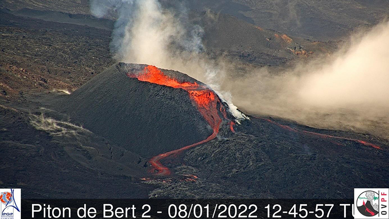 |
Figure 219. Webcam image of the active vent at Piton de la Fournaise on 8 January 2022, at 1645 local time, showing an occasional overflow from the lava lake in the cone. Courtesy of OVPF. |
On 9 January a new lava flow slowly advanced along the S margin of the flow field, reaching 1,800 m elevation. Hikers on 10 January observed smoke from an area in the S part of the caldera, likely from vegetation that had been set on fire from lava flows. The flow field continued to widen but had not significantly lengthened, and during 10-13 January the flow on the S margin of the field slowly advanced to the S wall of Enclos Fouqué (figure 220).
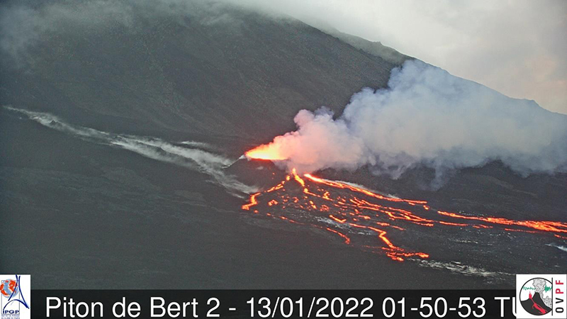 |
Figure 220. Webcam image of the active vent at Piton de la Fournaise on 13 January 2022, at 0550 local time, showing several lava streams from the cone advancing slowly downslope toward the S wall of the Enclos Fouqué caldera. Courtesy of OVPF. |
Activity decreased during 14-15 January, but then increased again during 15-16 January, though no overflows of the lake were recorded and lava was only periodically ejected above the rim. Some small vegetation fires were visible near the base of the caldera wall. Tremor decreased and the eruption stopped at 0210 on 17 January. On 21 January, OVPF lowered the Alert Level to Vigilance.
Numerous hotspots were identified in the MODVOLC system from 22 December through 30 January 2022. There were hotspots during eight days in December (10 pixels on 22 December) and 12 days in January (16 pixels on 14 January). Thermal anomalies recorded by the MIROVA system were also numerous during the eruption, with the Log Radiative Power extending into the high and very high range (figure 221).
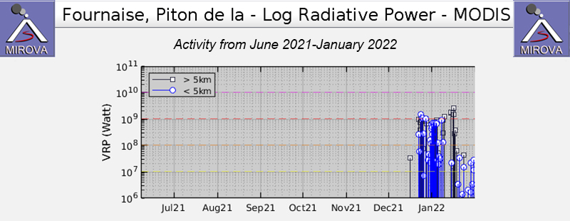 |
Figure 221. Graph of thermal anomalies at Piton de la Fournaise during June 2021-January 2022, as recorded by the MIROVA system, showing numerous high and very high Log Radiative Power hotspots during the 22 December 2021-17 January 2022 eruption. Courtesy of MIROVA. |
On 1 January 2022 infrared Sentinel-2 satellite images showed an extensive hotspot, presumably a lava flow, along the lower SSW flank, which continued through the middle of January. By 21 January and through the end of the month, images showed only one or two small bright spots of thermal activity.
The Sentinel-5P/TROPOMI satellite recorded high sulfur dioxide levels from 22 December 2021 through 10 January 2022 and a final discharge on 16 January. The most prominent and extensive pulses were on 22 December and 16 January (figure 222).
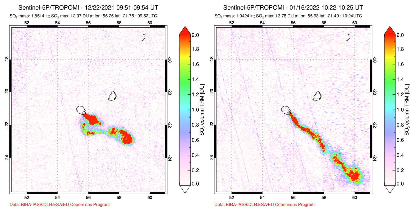 |
Figure 222. Images of high-level sulfur dioxide plumes recorded by the Sentinel-5P/TROPOMI instrument on 22 December 2021 and 16 January 2022 during the eruption at Piton de la Fournaise that began on 22 December 2021. Both plumes are tracking to the SW. Courtesy of NASA Global Sulfur Dioxide Monitoring Page. |
Geological Summary. Piton de la Fournaise is a massive basaltic shield volcano on the French island of Réunion in the western Indian Ocean. Much of its more than 530,000-year history overlapped with eruptions of the deeply dissected Piton des Neiges shield volcano to the NW. Three scarps formed at about 250,000, 65,000, and less than 5,000 years ago by progressive eastward slumping, leaving caldera-sized embayments open to the E and SE. Numerous pyroclastic cones are present on the floor of the scarps and their outer flanks. Most recorded eruptions have originated from the summit and flanks of Dolomieu, a 400-m-high lava shield that has grown within the youngest scarp, which is about 9 km wide and about 13 km from the western wall to the ocean on the E side. More than 150 eruptions, most of which have produced fluid basaltic lava flows, have occurred since the 17th century. Only six eruptions, in 1708, 1774, 1776, 1800, 1977, and 1986, have originated from fissures outside the scarps.
Information Contacts: Observatoire Volcanologique du Piton de la Fournaise, Institut de Physique du Globe de Paris, 14 route nationale 3, 27 ème km, 97418 La Plaine des Cafres, La Réunion, France (URL: http://www.ipgp.fr/fr); Hawai'i Institute of Geophysics and Planetology (HIGP) - MODVOLC Thermal Alerts System, School of Ocean and Earth Science and Technology (SOEST), Univ. of Hawai'i, 2525 Correa Road, Honolulu, HI 96822, USA (URL: http://modis.higp.hawaii.edu/); MIROVA (Middle InfraRed Observation of Volcanic Activity), a collaborative project between the Universities of Turin and Florence (Italy) supported by the Centre for Volcanic Risk of the Italian Civil Protection Department (URL: http://www.mirovaweb.it/); Global Sulfur Dioxide Monitoring Page, Atmospheric Chemistry and Dynamics Laboratory, NASA Goddard Space Flight Center (NASA/GSFC), 8800 Greenbelt Road, Goddard, Maryland, USA (URL: https://so2.gsfc.nasa.gov/); Sentinel Hub Playground (URL: https://www.sentinel-hub.com/explore/sentinel-playground).