Report on Dukono (Indonesia) — April 2022

Bulletin of the Global Volcanism Network, vol. 47, no. 4 (April 2022)
Managing Editor: Edward Venzke.
Research and preparation by Paul Berger.
Dukono (Indonesia) Continuing ash emissions, SO2 plumes, and thermal signals through March 2022
Please cite this report as:
Global Volcanism Program, 2022. Report on Dukono (Indonesia) (Venzke, E., ed.). Bulletin of the Global Volcanism Network, 47:4. Smithsonian Institution. https://doi.org/10.5479/si.GVP.BGVN202204-268010
Dukono
Indonesia
1.6992°N, 127.8783°E; summit elev. 1273 m
All times are local (unless otherwise noted)
The remote Dukono volcano on the island of Halmahera has been erupting continuously since 1933, with ash explosions, frequent ash plumes, and sulfur dioxide (SO2) plumes. This reports updates activity during October 2021-March 2022, and is based on the Pusat Vulkanologi dan Mitigasi Bencana Geologi (PVMBG; also known as Indonesian Center for Volcanology and Geological Hazard Mitigation, CVGHM), the Darwin Volcanic Ash Advisory Centre (VAAC), and satellite data. During this period, volcanism appears to have diminished relative to that indicated in previous reports.
According to PVMBG, during 19 and 22-26 October white-and-gray ash plumes rose as high as 300 m above the summit (1.5 km altitude) and drifted E and W. Based on satellite and wind model data, the Darwin VAAC reported that on 17 November ash plumes rose to an altitude of 2.1 km and drifted NE and ENE. During 18-23 November dense white plumes rose as high as 500 m (1.7 km altitude) and drifted NW, W, and SW, as reported by PVMBG. According to the Darwin VAAC, on 13 February 2022 ash plumes rose to an altitude of 2.1 km and drifted SW; during 26-31 March, ash plumes rose to an altitude of 2.1-2.4 km and drifted SE, E, and ENE.
Satellite views of the volcano often showed thermal anomalies, but good views were obscured by weather clouds throughout most of the reporting period. However, clouds cleared sufficiently on several days to allow clear observations of thermal anomalies at the summit crater and ash plumes, such as on 12 October 2021, 25 January 2022, and 31 March 2022 (figure 28). Thermal measurements made by MODIS satellite instruments and processed by MIROVA showed intermittent low-to-moderate power activity, with a greater concentration of signals during October 2021. The only thermal alerts recorded by MODIS-MODVOLC were on 12 October 2021 and 7 and 30 January 2022. The NASA Global Sulfur Dioxide page, using data from the TROPOMI instrument aboard the Sentinel-5P satellite, showed numerous days with strong SO2 plumes near the volcano (figure 29). The number of days with high SO2 concentrations was greatest in October 2021 (15), decreasing in November (11), December (4), January 2022 (10), February (5), and March (8).
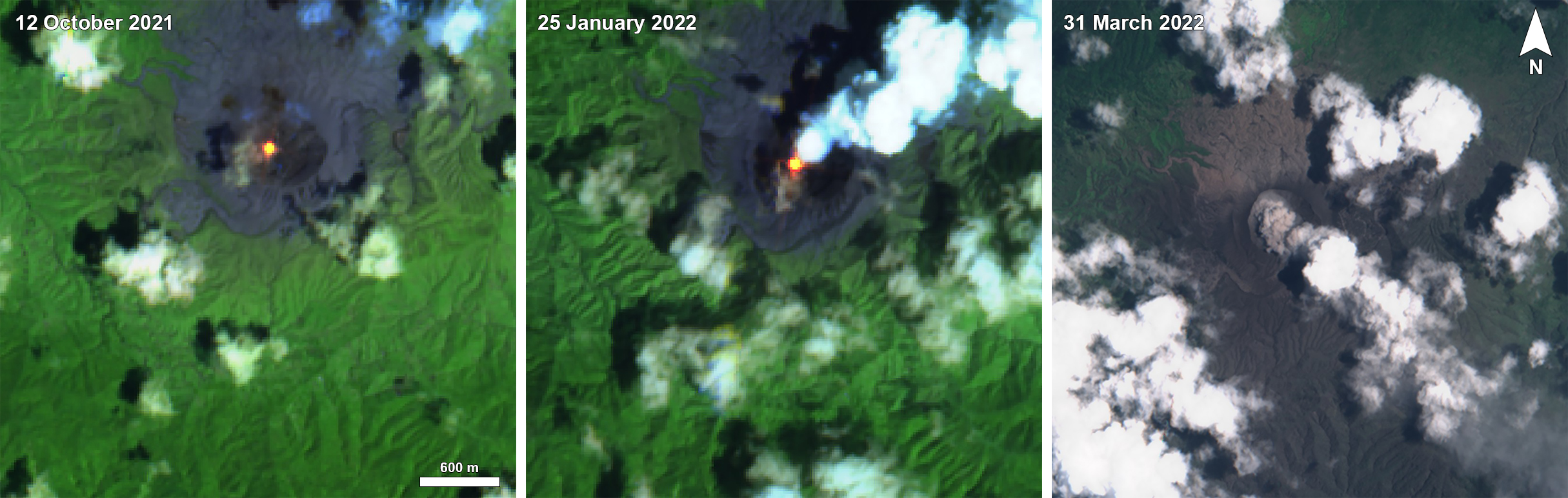 |
Figure 28. Intermittent clear satellite views Dukono during October 2021-March 2022 showed ongoing volcanism. A clear thermal anomaly was detected in the summit crater on 12 October 2021 (left), possibly with a small ash plume drifting SW. On 25 January 2022 (center) a stronger thermal signal could be seen along with a steam plume and possible small ash emission. A distinct ash plume on 31 March 2022 (right) was consistent with Darwin VAAC reports. Thermal anomalies were also present on less favorable viewing days. Sentinel-2 images with false color rendering (bands 12, 11, 4) (left and center), and natural rendering (bands 4, 3, 2) (right). Courtesy of Sentinel Hub Playground. |
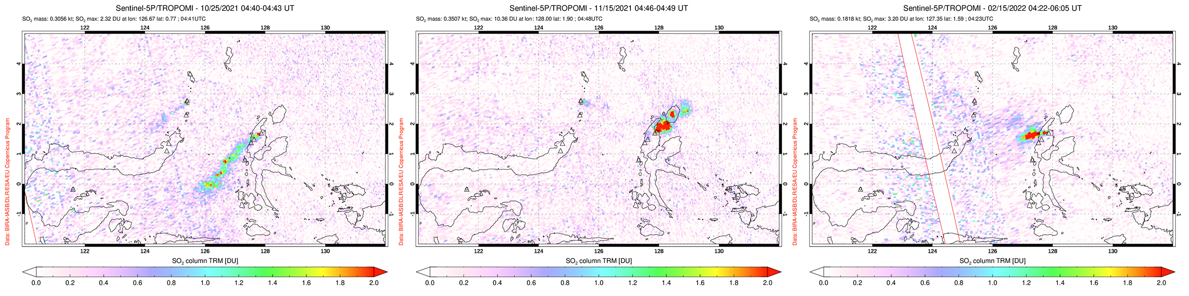 |
Figure 29. Representative maps from the October 2021-March 2022 period showing strong SO2 plumes from Dukono detected using the TROPOMI instrument on the Sentinel-5P satellite. Plumes drifted SW on 25 October 2021 during an explosive period (left), NE on 15 November 2021 (center), and W on 15 February after an explosion two days earlier (right). Courtesy of the NASA Global Sulfur Dioxide Monitoring Page. |
Geological Summary. The Dukono complex in northern Halmahera is on an edifice with a broad, low profile containing multiple peaks and overlapping craters. Almost continuous explosive eruptions, sometimes accompanied by lava flows, have occurred since 1933. During a major eruption in 1550 CE, a lava flow filled in the strait between Halmahera and the Gunung Mamuya cone, 10 km NE. Malupang Wariang, 1 km SW of the summit crater complex, contains a 700 x 570 m crater that has also had reported eruptions.
Information Contacts: Pusat Vulkanologi dan Mitigasi Bencana Geologi (PVMBG, also known as Indonesian Center for Volcanology and Geological Hazard Mitigation, CVGHM), Jalan Diponegoro 57, Bandung 40122, Indonesia (URL: http://www.vsi.esdm.go.id/); Darwin Volcanic Ash Advisory Centre (VAAC), Bureau of Meteorology, Northern Territory Regional Office, PO Box 40050, Casuarina, NT 0811, Australia (URL: http://www.bom.gov.au/info/vaac/); NASA Global Sulfur Dioxide Monitoring Page, Atmospheric Chemistry and Dynamics Laboratory, NASA Goddard Space Flight Center (NASA/GSFC), 8800 Greenbelt Road, Goddard, Maryland, USA (URL: https://so2.gsfc.nasa.gov/); Sentinel Hub Playground (URL: https://www.sentinel-hub.com/explore/sentinel-playground); MIROVA (Middle InfraRed Observation of Volcanic Activity), a collaborative project between the Universities of Turin and Florence (Italy) supported by the Centre for Volcanic Risk of the Italian Civil Protection Department (URL: http://www.mirovaweb.it/); Halmahera Post (URL: https://halmaherapost.com/); Hawai'i Institute of Geophysics and Planetology (HIGP) - MODVOLC Thermal Alerts System, School of Ocean and Earth Science and Technology (SOEST), Univ. of Hawai'i, 2525 Correa Road, Honolulu, HI 96822, USA (URL: http://modis.higp.hawaii.edu/).