Report on Taal (Philippines) — April 2022

Bulletin of the Global Volcanism Network, vol. 47, no. 4 (April 2022)
Managing Editor: Edward Venzke.
Edited by Kadie L. Bennis.
Taal (Philippines) Phreatomagmatic eruption on 26 March 2022 included 66 explosions that ejected wet ash
Please cite this report as:
Global Volcanism Program, 2022. Report on Taal (Philippines) (Bennis, K.L., and Venzke, E., eds.). Bulletin of the Global Volcanism Network, 47:4. Smithsonian Institution. https://doi.org/10.5479/si.GVP.BGVN202204-273070
Taal
Philippines
14.0106°N, 120.9975°E; summit elev. 311 m
All times are local (unless otherwise noted)
Taal, located in the Philippines, is part of a caldera system in southern Luzon Island. Recorded eruptions date back to 3,580 BCE. The caldera is 15 x 20 km and contains Lake Taal, which has a depth of 160 m, and an island that also contains a lake within the Main Crater. Eruptive activity during 1-9 July 2021 was characterized by phreatomagmatic explosions, gas-and-steam emissions, including sulfur dioxide emissions, and seismicity (BGVN 46:10). This report describes activity during October 2021-March 2022 using reports from the Philippine Institute of Volcanology and Seismology (PHIVOLCS) and satellite data. Prior to a notable eruption on 26 March, PHIVOLCS described “phreatomagmatic bursts” on 15 and 22 November 2021, 29-30 January, 2 and 10 February, and 25 March 2022; similar events occurred during 27-28 March.
Activity was relatively low during October through mid-November. Frequent volcanic earthquakes and low-level background tremor had persisted since the activity in early July. Gas-and-steam plumes rose as high as 3 km from the Main Crater on 18 November and drifted in different directions. Each day, an average sulfur dioxide flux was recorded and vog was commonly observed around the vicinity. During October, the SO2 emissions ranged from 4,620 to 25,456 t/d, the latter of which was recorded on 5 October. On 30 October as many as 103 volcanic earthquakes and 21 volcanic tremor events were detected. In November, daily sulfur dioxide emissions ranged from 1,727-19,463 t/d, the highest flux occurring on 6 November. On 11 November there were 223 volcanic tremor events that were detected, in addition to 180 volcanic tremor events.
A short phreatomagmatic burst was recorded at 2339 on 15 November, followed by two more on 17 November at 0146 and 0254. The first event produced a plume that rose 2.4 km altitude and drifted SW while the next two events generated plumes 400-500 m high, based on thermal camera images. Three more short phreatomagmatic bursts were detected at 0811, 0817, and 0834 on 22 November each lasted 1-5 minutes; these events produced plumes 200-1,500 m high that drifted SW, according to thermal camera images.
Low-level activity continued during December 2021 and most of January 2022. Frequent volcanic earthquakes and low-level background tremor persisted; as many as 139 volcanic earthquakes and 114 volcanic tremor events were detected on 16 December. Intermittent gas-and-steam emissions rose as high as 3 km above the Main Crater, drifting in various directions. The sulfur dioxide daily flux ranged from 2,684-13,634 t/d throughout December, the highest value recorded on 24 December. Vog was also visible in the surrounding area. During 26 December through 29 January, the seismic network detected no more than one volcanic earthquake, though low-level background tremor continued. During January the sulfur dioxide daily flux ranged from 4,829 to 18,705 t/d; the largest was recorded on 27 January.
A series of nine weak phreatomagmatic bursts detected in the Main Crater between 1550 on 29 January and 0449 on 30 January produced gas-and-steam emissions that rose 400-900 m high, according to visual and thermal cameras. These events lasted between 10 seconds and two minutes and were accompanied by distinct infrasound signals.
During February through March, intermittent gas-and-steam emissions rose as high as 2.5 km and drifted in various directions. Sulfur dioxide emissions ranged from 2,456-10,270 t/d during February, the highest of which occurred on 12 February. As many as 169 volcanic tremor events were detected on 2 February. A phreatomagmatic burst recorded at 1555 on 2 February lasted two minutes and generated a plume that rose 300 m high and drifted SW. Another short phreatomagmatic burst was recorded on 10 February at 1616, based on seismic records and visual cameras, which produced a plume 300 m high and drifted SW within the Main Crater. Sulfur dioxide fluxes were in the 1,140-21,211 t/d range during March, the highest occurring on 16 March. On 22 March as many as 47 volcanic earthquakes and 25 volcanic tremor events were recorded. A phreatomagmatic burst was reported at 0226 on 25 March, according to seismic records and visual cameras; a plume rose 500 m above the Main Crater.
A phreatomagmatic eruption during 0722-0859 on 26 March consisted of as many as 66 explosions, prompting PHIVOLCS to raise the Volcano Alert Level (VAL) from 2 to 3 (on a scale of 0-5) at 0800 (figure 26). Eruption plumes rose as high as 3 km and wet ash that smelled of sulfur fell along the Calauit and Alas-as shorelines, and on the lakeshore of Banyaga, Agoncillo, Batangas. According to the National Disaster Risk Reducation and Management Council (NDRRMC), by 27 March about 2,961 people had been evacuated from Bilibinwang and Banyaga, Agoncillo and Boso-boso, Gulod and eastern Bugaan East, Laurel, Batangas Province.
 |
Figure 26. Webcam image of the phreatomagmatic eruption at Taal’s Main Crater on 26 March 2022, recorded by the Main Crater Observation Station (VTMC). Courtesy of PHIVOLCS. |
Two subsequent phreatomagmatic events the following day, at 0434 and 0504 on 27 March, produced plumes that rose 400-800 m above Main Crater. On 28 March three phreatomagmatic bursts from the Main Crater were detected at 0930, 0933, and 0946, generating 400-800 m plumes that drifted SW. On 27 March PHIVOLCS raised the Volcano Alert Level (VAL) from 2 to 3 (on a scale of 0-5). The VAL was then lowered from 3 to 2 on 9 April due to the decrease in gas-and-steam emissions and seismicity.
MIROVA (Middle InfraRed Observation of Volcanic Activity) analysis of MODIS satellite data detected frequent low- to-moderate thermal anomalies during mid-October 2021 through March 2022 (figure 27). A brief pause in thermal activity was visible during early October, and short periods of fewer anomalies occurred during mid- and late December. Some of these anomalies were also detected by MODVOLC using infrared satellite data on 22, 25, 26, 29, and 31 October, 5, 7, 9, 10, 17, 18, 21, 23, and 25 November, 14, 18, 22, and 23 December 2021, 3, 6, 15, 22, 23, 24, 29, and 31 January 2022, 5, 9, 11, 14, 15, 16, and 20 February, and 1, 11, 19, 22, 24, and 26 March. Frequent sulfur dioxide plumes of varying strength were detected in the Sentinel-5P satellite throughout the reporting period (figure 28).
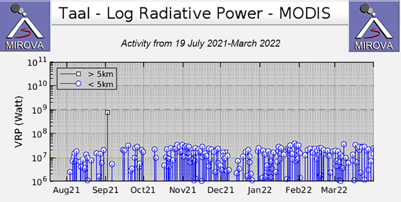 |
Figure 27. Frequent thermal anomalies were detected near the summit of Taal during mid-October 2021 through March 2022, as shown by the MIROVA graph (Log Radiative Power). There was a brief break in thermal activity during early October and less anomalies occurred during mid- and late- December. Courtesy of MIROVA. |
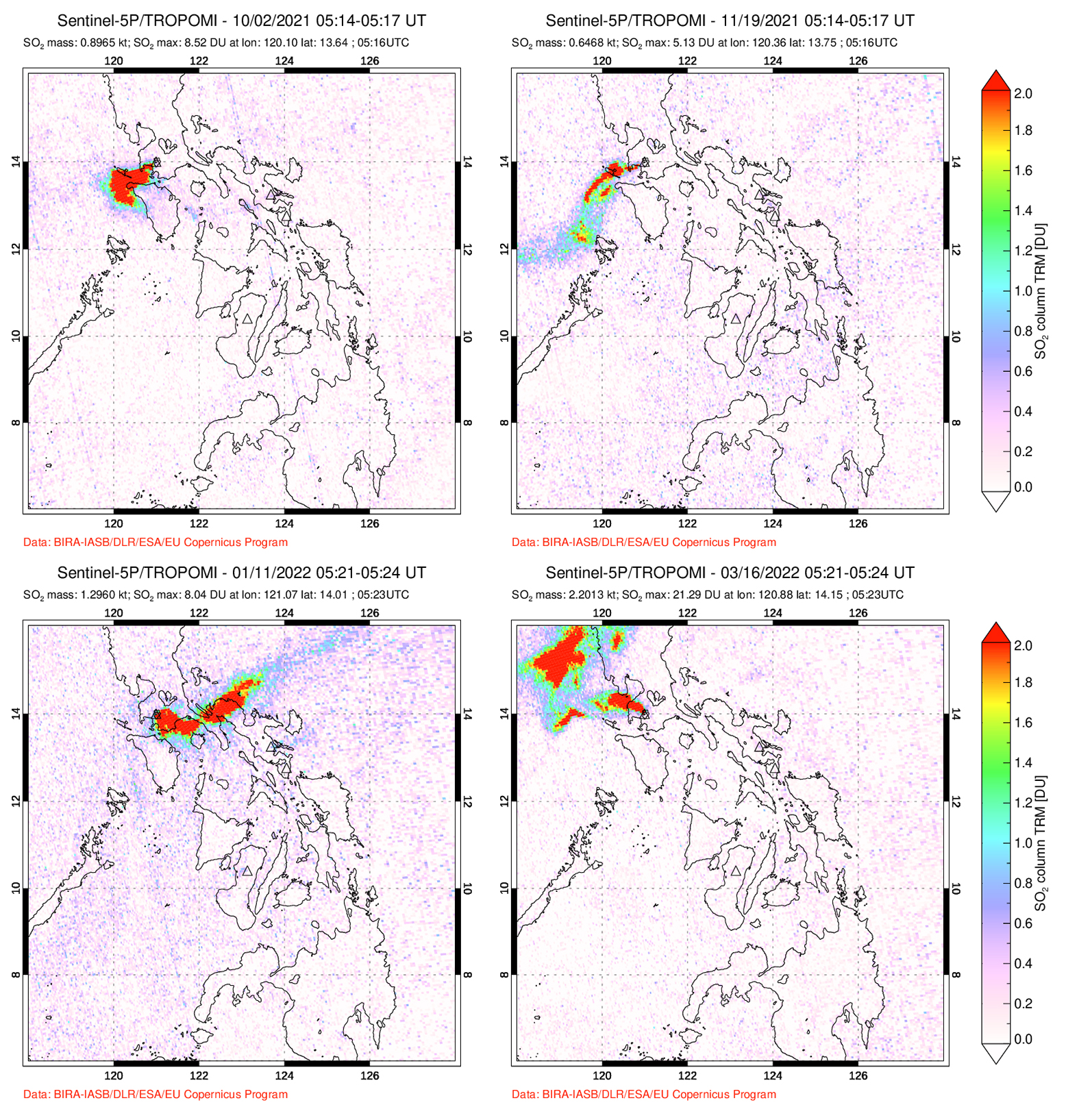 |
Figure 28. Strong sulfur dioxide plumes were detected at Taal on 2 October 2021 (top left), 19 November 2021 (top right), 11 January 2022 (bottom left), and 16 March 2022 (bottom right). Plumes drifted in different directions and those shown here exceeded 2 Dobson Units (DUs). Courtesy of NASA Global Sulfur Dioxide Monitoring Page. |
Geological Summary. Taal is one of the most active volcanoes in the Philippines and has produced some powerful eruptions. The 15 x 20 km Talisay (Taal) caldera is largely filled by Lake Taal, whose 267 km2 surface lies only 3 m above sea level. The maximum depth of the lake is 160 m, with several submerged eruptive centers. The 5-km-wide Volcano Island in north-central Lake Taal is the location of all observed eruptions. The island is composed of coalescing small stratovolcanoes, tuff rings, and scoria cones. Powerful pyroclastic flows and surges have caused many fatalities.
Information Contacts: Philippine Institute of Volcanology and Seismology (PHIVOLCS), Department of Science and Technology, University of the Philippines Campus, Diliman, Quezon City, Philippines (URL: http://www.phivolcs.dost.gov.ph/); The National Disaster Risk Reduction and Management Council (NDRRMC), NDRRMC Building, Camp General Emilio Aguinaldo, Quezon City, Philippines (URL: https://ndrrmc.gov.ph/index.php); Philippine News Agency (PNA), Philippine Information Agency Building, Visayas Avenue, Barangay Vasra, Quezon City, Philippines (URL: https://www.pna.gov.ph/); MIROVA (Middle InfraRed Observation of Volcanic Activity), a collaborative project between the Universities of Turin and Florence (Italy) supported by the Centre for Volcanic Risk of the Italian Civil Protection Department (URL: http://www.mirovaweb.it/); NASA Global Sulfur Dioxide Monitoring Page, Atmospheric Chemistry and Dynamics Laboratory, NASA Goddard Space Flight Center (NASA/GSFC), 8800 Greenbelt Road, Goddard, Maryland, USA (URL: https://so2.gsfc.nasa.gov/).