Report on Popocatepetl (Mexico) — April 2022

Bulletin of the Global Volcanism Network, vol. 47, no. 4 (April 2022)
Managing Editor: Edward Venzke.
Edited by Kadie L. Bennis.
Popocatepetl (Mexico) Continuing minor ash emissions and crater incandescence during August 2021-January 2022
Please cite this report as:
Global Volcanism Program, 2022. Report on Popocatepetl (Mexico) (Bennis, K.L., and Venzke, E., eds.). Bulletin of the Global Volcanism Network, 47:4. Smithsonian Institution. https://doi.org/10.5479/si.GVP.BGVN202204-341090
Popocatepetl
Mexico
19.023°N, 98.622°W; summit elev. 5393 m
All times are local (unless otherwise noted)
Popocatépetl is located 70 km SE of Mexico City, Mexico, and contains a 400 x 600 m wide crater. Records of activity date back to the 14th century and the current eruption period has been ongoing since January 2005, which has included numerous episodes of lava-dome growth and destruction within the summit caldera. Recently, activity has consisted of intermittent crater incandescence, frequent ash explosions, and ash emissions. This report covers the period from August 2021 through January 2022, characterized by daily low-intensity gas-and-ash emissions, volcano-tectonic tremors, and crater incandescence, based on information from México's Centro Nacional de Prevención de Desastres (CENAPRED) and various satellite data.
Gas-and-steam emissions, some of which contained ash, remained ongoing throughout August 2021-January 2022. Some minor ashfall was reported during mid-September. CENAPRED reported the number of low-intensity gas-and-ash emissions or “exhalations” and the number of minutes of tremor in their daily reports (figure 185). Tremor activity reached an average of 261 minutes per day from August to January 2022, but dropped off significantly after September. A total of about 72 volcano-tectonic (VT) tremors were detected throughout the reporting period. The average number of gas-and-ash emissions was 54 per day, with a maximum number of 260 on 25 September. Occasional small to moderate sulfur dioxide plumes were detected with satellite instruments each month (figure 186).
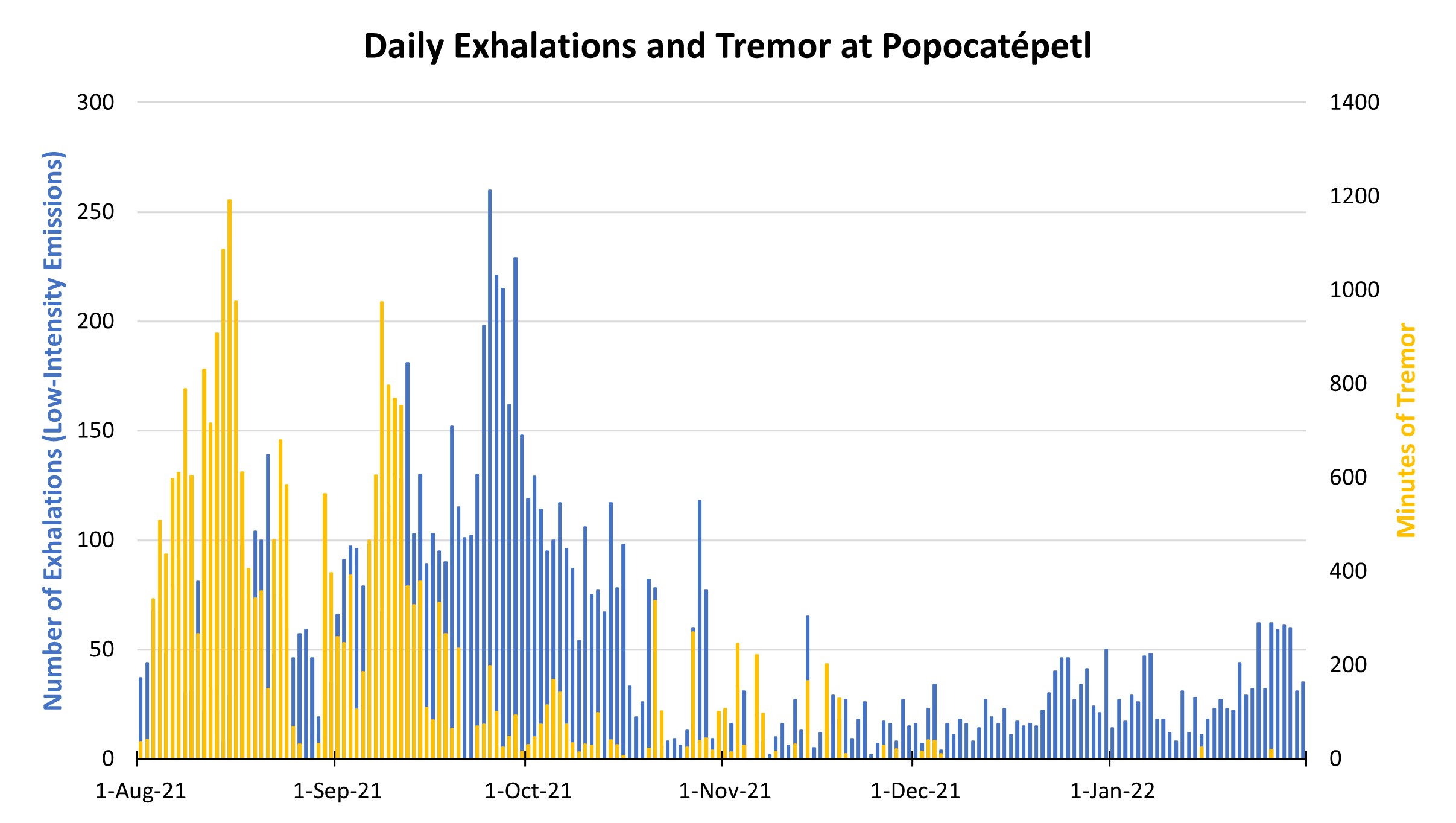 |
Figure 185. CENAPRED reported the number of daily “exhalations” (in blue, left scale), and the number of minutes of tremor (in gold, right scale) at Popocatépetl each day during August 2021-January 2022. The number of daily exhalations fluctuated throughout the period, reaching as high as 260 on 25 September 2021, followed by a gradual decline through the rest of the reporting period. Similarly, there was some fluctuation in the duration of tremors during August through September; on 15 August 2021 a maximum duration of 1,192 minutes of tremor was detected. After September, the minutes of tremor decreased significantly and often were not detected. Data from CENAPRED daily reports. |
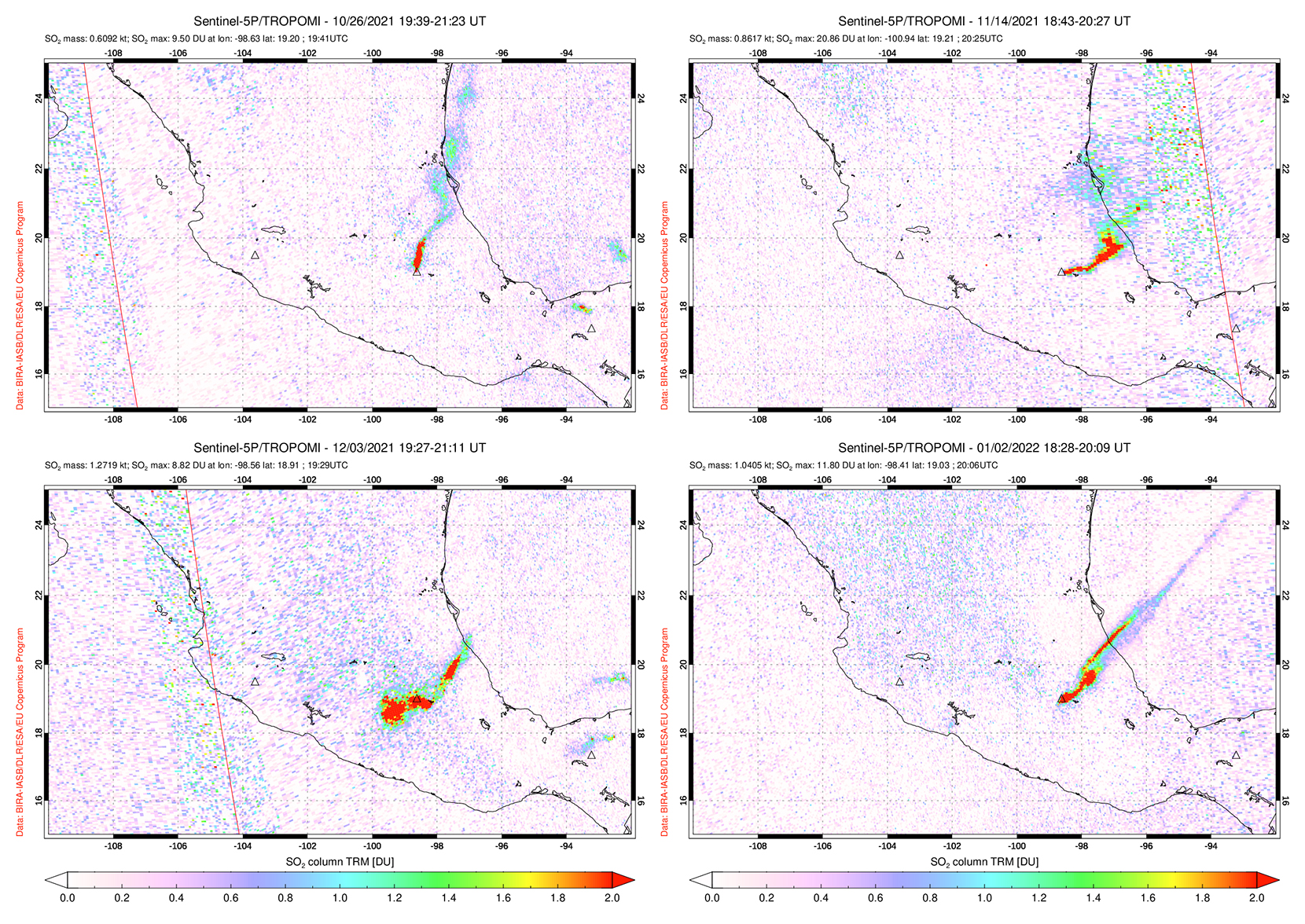 |
Figure 186. Moderate sulfur dioxide plumes were detected at Popocatépetl intermittently from August 2021 through January 2022, as seen on 26 October (top left), 14 November (top right), 3 December (bottom left) 2021, and 2 January (bottom right) 2022. Courtesy of NASA Global Sulfur Dioxide Monitoring Page. |
MODIS thermal anomaly data provided through MIROVA showed low-level, intermittent activity during August through early October 2021, followed by a brief break in activity (figure 187). Thermal activity resumed in early November at a higher level and frequency compared to previous months. According to data from MODVOLC thermal alerts, a total of nine hotspots were detected on 10 and 16 September, 14 and 28 November, 6 December, and 1, 2, and 15 January 2022. Sentinel-2 infrared satellite imagery also showed persistent thermal anomalies in the summit crater multiple times each month from August 2021 through January 2022 (figure 188).
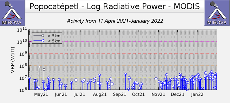 |
Figure 187. The MIROVA graph of thermal anomalies at Popocatépetl from 11 April 2021 through January 2022 shows low-level, intermittent activity during May through early October, followed by a short break. Activity increased in both power and frequency in November and remained elevated through January. Courtesy of MIROVA. |
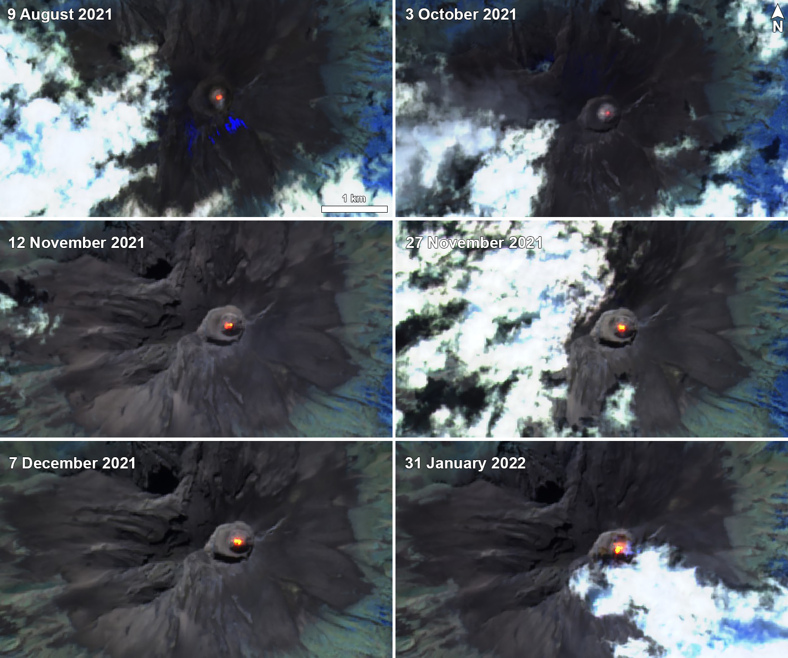 |
Figure 188. Sentinel-2 infrared satellite images showing thermal anomalies in the summit crater of Popocatépetl on 9 August (top left), 3 October (top right), 12 November (middle left), 27 November (middle right), 7 December (bottom left) 2021, and 31 January (bottom right) 2022. Images use Atmospheric penetration rendering (bands 12, 11, 8a). Courtesy of Sentinel Hub Playground. |
Activity during August and September was relatively high compared to the rest of the reporting period. There were an average number of 92 exhalations per day, which consisted mostly of water vapor, volcanic gases, and a small amount of ash, the most of which occurred on 25 September with 260. On clear nights, crater incandescence was observed, though cloudy weather was common. About 36 VT earthquakes were also noted throughout the two months. A total of 46 minor to moderate explosions were detected. A moderate explosion was reported on 6 August at 2137, accompanied by incandescent material that was ejected a short distance from the crater.
Explosions were detected at 2135, 2254, and 2345 on 1 September, followed by a VT earthquake. Two explosions on 11 September (at 1222 and 1323) generated ash plumes that rose 1.8-2 km above the crater, accompanied by incandescent material ejected from the crater. A gas-and-ash plume at 1015 on 15 September rose 2.2 km above the crater; a minor explosion at 1441 that day produced an ash plume 1.8 km above the crater and drifted NW. According to information from the National Center for Communication and Civil Protection Operations (CENACOM), light ashfall was reported in the municipalities of Valle de Chalco, Chiautla, Ixtapaluca, Nezahualcóyotl, La Paz, Ecatepec, Ayapango, Temamatla, Tenango del Aire, Tlalmanalco, Amecameca, Tepetlixpa, Tlalnepantla, and Acolman in the México State. Three minor explosions on 17 September resulted in light ashfall in the municipalities of Valle de Chalco, Ixtapaluca, Chalco, Tlalmanalco, Amecameca, Ayapango, Tenango del Aire, Temamatla, and Ecatzingo, as well as in Iztapalapa, Xochimilco, and Tlahuac in México City. Some ashfall was reported on 18 September in Cuernavaca.
The number of daily exhalations and duration of VT earthquakes declined after September, though they continued to be detected during October and November, with an average of 43 exhalations per day; 129 exhalations occurred on 2 October. A total of 45 VT earthquakes was detected during these two months and 11 minor to moderate explosions were recorded. On 2 October an explosion at 0619 generated an ash plume that rose 1.2 km above the crater (figure 189) and ejected incandescent material onto the slopes. A low-intensity explosion detected at 0057 on 5 October produced an ash plume that rose 800 m above the crater and drifted W.
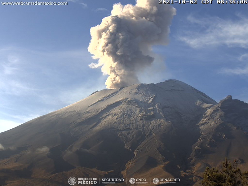 |
Figure 189. Webcam image of a gas-and-ash plume that rose 1.2 km above the crater of Popocatépetl on 2 October 2021. Courtesy of CENAPRED daily report. |
The Institute of Geology at the National Autonomous University of Mexico (UNAM), with support from the National Guard and CENAPRED, conducted an overflight on 5 November to make visual observations; the internal crater had a diameter of 390-400 m and a depth of 160-200 m (figure 190), and no new lava was seen. On 19 November an explosion at 1714 generated an ash plume that rose 2 km above the crater and drifted NE. A minor explosion on at 0230 on 21 November produced an ash plume that rose 600 m above the crater and drifted NW, and at 0136 the next day another small explosion produced an ash plume that rose 800 m above the crater and drifted NE.
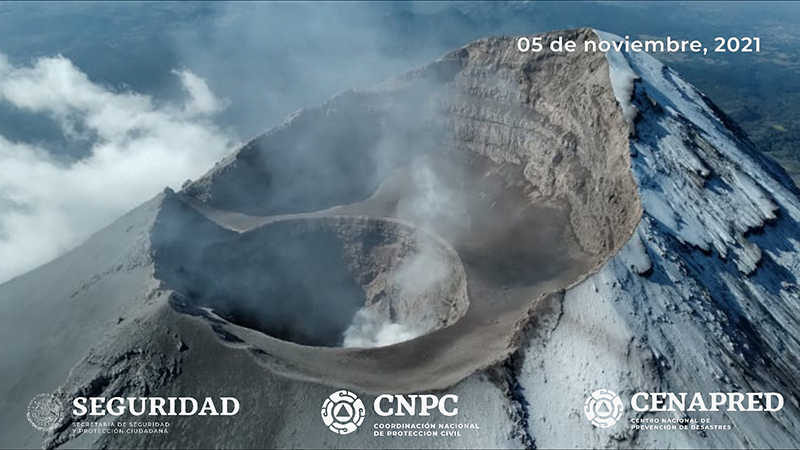 |
Figure 190. Aerial photo of the summit crater and inner crater of Popocatépetl taken on 5 November 2021. The internal crater had an approximate diameter of 400 m and a depth of 200 m. Courtesy of CENAPRED daily report. |
Activity remained relatively low during December and January 2022, consisting of an average number of 27 exhalations reported per day, a total of 47 VT earthquakes, and only six minor to moderate explosions, most of which occurred during January. A minor explosion was detected on 13 January at 0420, producing an ash plume that rose 600 m above the crater and drifted SE. The next day on 14 January a minor explosion at 2255 generated a plume containing a small amount of ash rose 1 km above the crater and drifted NE. Some material was also ejected a short distance from the crater (figure 191).
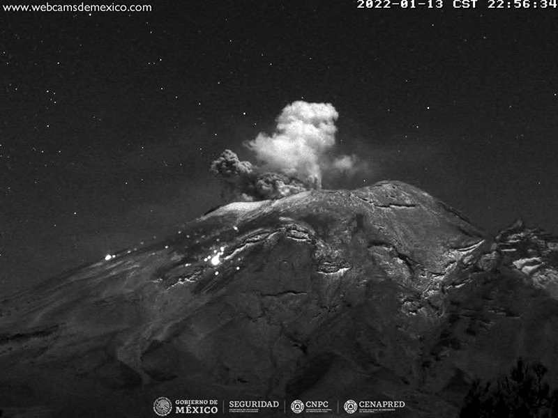 |
Figure 191. Webcam image of an explosion at Popocatépetl on 13 January 2022 that generated an ash plume 1 km above the crater that drifted NE. Incandescent material was ejected a short distance from the crater. Courtesy of CENAPRED daily report. |
Geological Summary. Volcán Popocatépetl, whose name is the Aztec word for smoking mountain, rises 70 km SE of Mexico City to form North America's 2nd-highest volcano. The glacier-clad stratovolcano contains a steep-walled, 400 x 600 m wide crater. The generally symmetrical volcano is modified by the sharp-peaked Ventorrillo on the NW, a remnant of an earlier volcano. At least three previous major cones were destroyed by gravitational failure during the Pleistocene, producing massive debris-avalanche deposits covering broad areas to the south. The modern volcano was constructed south of the late-Pleistocene to Holocene El Fraile cone. Three major Plinian eruptions, the most recent of which took place about 800 CE, have occurred since the mid-Holocene, accompanied by pyroclastic flows and voluminous lahars that swept basins below the volcano. Frequent historical eruptions, first recorded in Aztec codices, have occurred since Pre-Columbian time.
Information Contacts: Centro Nacional de Prevención de Desastres (CENAPRED), Av. Delfín Madrigal No.665. Coyoacan, México D.F. 04360, México (URL: http://www.cenapred.unam.mx/, Daily Report Archive https://www.gob.mx/cenapred/archivo/articulos); MIROVA (Middle InfraRed Observation of Volcanic Activity), a collaborative project between the Universities of Turin and Florence (Italy) supported by the Centre for Volcanic Risk of the Italian Civil Protection Department (URL: http://www.mirovaweb.it/); Hawai'i Institute of Geophysics and Planetology (HIGP) - MODVOLC Thermal Alerts System, School of Ocean and Earth Science and Technology (SOEST), Univ. of Hawai'i, 2525 Correa Road, Honolulu, HI 96822, USA (URL: http://modis.higp.hawaii.edu/); NASA Global Sulfur Dioxide Monitoring Page, Atmospheric Chemistry and Dynamics Laboratory, NASA Goddard Space Flight Center (NASA/GSFC), 8800 Greenbelt Road, Goddard, Maryland, USA (URL: https://so2.gsfc.nasa.gov/); Sentinel Hub Playground (URL: https://www.sentinel-hub.com/explore/sentinel-playground).