Report on Chikurachki (Russia) — May 2022
Bulletin of the Global Volcanism Network, vol. 47, no. 5 (May 2022)
Managing Editor: Edward Venzke.
Edited by Kadie L. Bennis.
Chikurachki (Russia) Explosions and ash plumes during late January-early February 2022
Please cite this report as:
Global Volcanism Program, 2022. Report on Chikurachki (Russia) (Bennis, K.L., and Venzke, E., eds.). Bulletin of the Global Volcanism Network, 47:5. Smithsonian Institution. https://doi.org/10.5479/si.GVP.BGVN202205-290360
Chikurachki
Russia
50.324°N, 155.461°E; summit elev. 1781 m
All times are local (unless otherwise noted)
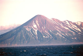
Chikurachki is a relatively small cone located on Paramushir Island in the northern Kurile Islands. Reported eruptions date back to 1690 with the most recent previous activity during July-August 2016. Activity has consisted of moderate explosive eruptions, ash plumes, sulfur dioxide emissions, and some ashfall (BGVN 41:11). This report updates information from August 2016 through April 2022, which includes a new eruption during 31 January through 2 February 2022 characterized by ash explosions. Information primarily comes from the Kamchatka Volcanic Eruptions Response Team (KVERT), the Tokyo Volcanic Ash Advisory Center (VAAC), and satellite information.
The July-August 2016 eruption began on 27 July when an ash plume rose to an altitude of 4-5 km and drifted 176 km NE (BGVN 41:11). Notable activity continued on 18 August when an ash plume rose over 2.7 km above the crater and drifted 280 km NE. Based on satellite observations, KVERT reported that a gas-and-ash plume rose to 2.5 km altitude on 29 August and drifted 35 km SE.
Low activity was reported from September 2016 through mid-March 2021, after which occasional dark brown to black ash deposits were visible in Sentinel-2 satellite imagery. On 21 March 2021 brown deposits were seen on the SE flank, where light ashfall was also visible on 5 and 7 April. Ash covered much of the summit area on 30 April, accompanied by an ash plume that drifted SW. An ash plume deposited ash on the SE flank on 5 May. Strong ashfall surrounded the perimeter of the summit on 12 May, which was also noted on 15-25 May; an ash plume that drifted W was visible on 15 May (figure 13). Ashfall was visible on multiple flanks on 4, 6, 11, 16, 19, 24, and 29 June, and 1, 4, 6, 9, 11, 16, and 21 July. A light brown ash plume drifted SE on 5 August. On 10 August a gray ash plume drifted S, and on 23 and 25 August a brown ash plume drifted W (figure 13).
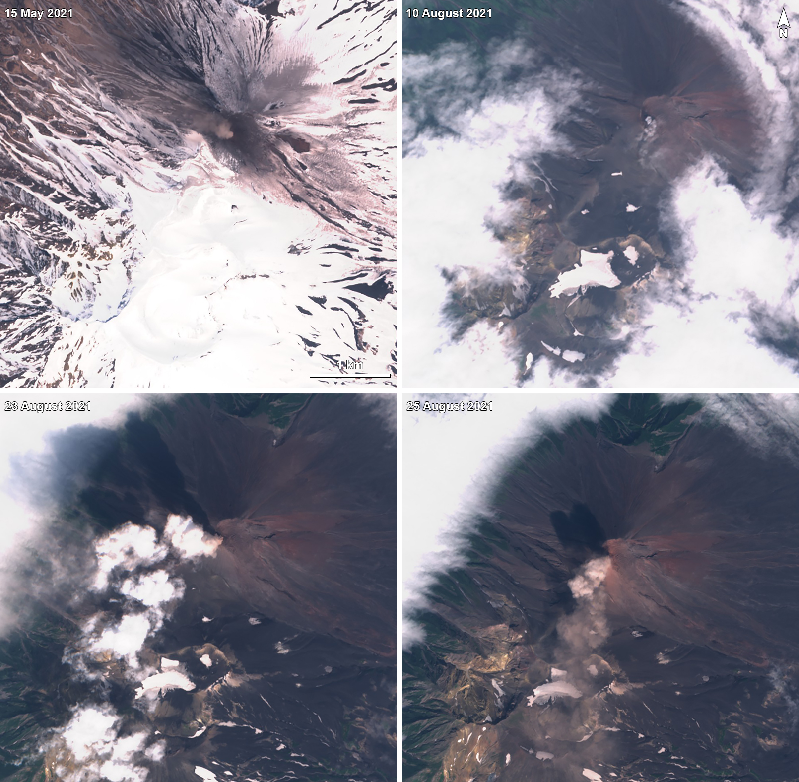 |
Figure 13. Sentinel-2 satellite images showing brown-to-gray plumes rising from Chikurachki on 15 May (top left), 10 August (top right), 23 August (bottom left), and 25 August (bottom right) 2021. Plumes drifted in different directions. Ash deposits were visible on the SE and NW flanks of the volcano on 15 May 2021. Images use “Natural color” rendering (bands 4, 3, 2). Courtesy of Sentinel Hub Playground. |
Thin ash deposits were visible on the SW flank on 17 January 2022 in a Sentinel-2 satellite image, accompanied by a white gas-and-steam emission. An explosive eruption began at 0300 on 31 January 2022 according to KVERT. Strong gas-and-steam emissions were first visible at 1200 on 31 January and possibly contained some ash. The plume rose as high as 5 km altitude and drifted 80 km SW. A thermal anomaly was also noted in the crater area on 31 January and KVERT raised the ACC to Orange. Ash plumes rose as high as 3 km altitude and drifted 104 km WSW on 1 February, based on a satellite image. On 2 February explosions produced ash plumes that rose to 5 km altitude and drifted 255 km S and SE. Ash explosions were no longer detected by 3 February and as a result, the ACC was lowered to Yellow. On 5, 12, and 22 April, some fresh ash deposits were visible in satellite images surrounding the summit crater (figure 14).
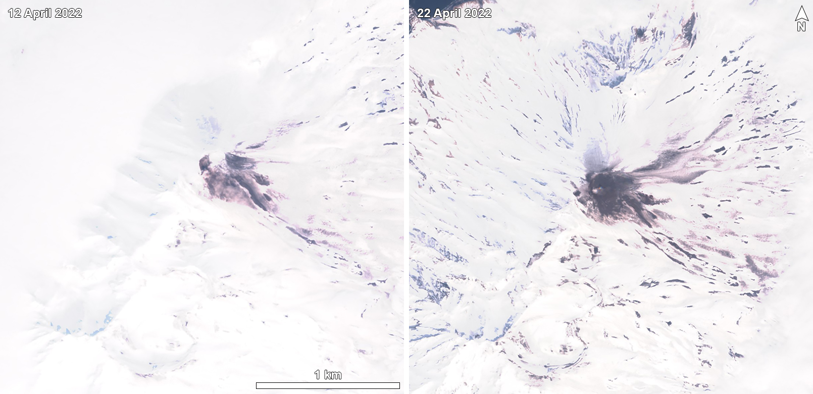 |
Figure 14. Sentinel-2 satellite images showing fresh black ash deposits surrounding the summit crater and to the E of Chikurachki on 12 (left) and 22 (right) April 2022. Images use “Natural color” rendering (bands 4, 3, 2). Courtesy of Sentinel Hub Playground. |
Geological Summary. Chikurachki, the highest volcano on Paramushir Island in the northern Kuriles, is a relatively small cone constructed on a high Pleistocene edifice. Oxidized basaltic-to-andesitic scoria deposits covering the upper part of the young cone give it a distinctive red color. Frequent basaltic Plinian eruptions have occurred during the Holocene. Lava flows have reached the sea and formed capes on the NW coast; several young lava flows are also present on the E flank beneath a scoria deposit. The Tatarinov group of six volcanic centers is located immediately to the south, and the Lomonosov cinder cone group, the source of an early Holocene lava flow that reached the saddle between it and Fuss Peak to the west, lies at the southern end of the N-S-trending Chikurachki-Tatarinov complex. In contrast to the frequently active Chikurachki, the Tatarinov centers are extensively modified by erosion and have a more complex structure. Tephrochronology gives evidence of an eruption around 1690 CE from Tatarinov, although its southern cone contains a sulfur-encrusted crater with fumaroles that were active along the margin of a crater lake until 1959.
Information Contacts: Kamchatka Volcanic Eruptions Response Team (KVERT), Far East Division, Russian Academy of Sciences, 9 Piip Blvd., Petropavlovsk-Kamchatsky, 683006, Russia (URL: http://www.kscnet.ru/ivs/); Tokyo Volcanic Ash Advisory Center (VAAC), Tokyo, Japan (URL: http://ds.data.jma.go.jp/svd/vaac/data/); Sentinel Hub Playground (URL: https://www.sentinel-hub.com/explore/sentinel-playground).