Report on Great Sitkin (United States) — May 2022
Bulletin of the Global Volcanism Network, vol. 47, no. 5 (May 2022)
Managing Editor: Edward Venzke.
Research and preparation by Paul Berger.
Great Sitkin (United States) Continuing dome growth and lava effusion through April 2022
Please cite this report as:
Global Volcanism Program, 2022. Report on Great Sitkin (United States) (Venzke, E., ed.). Bulletin of the Global Volcanism Network, 47:5. Smithsonian Institution. https://doi.org/10.5479/si.GVP.BGVN202205-311120
Great Sitkin
United States
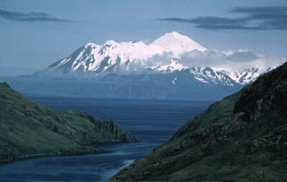
52.076°N, 176.13°W; summit elev. 1740 m
All times are local (unless otherwise noted)
Great Sitkin, in the Aleutian island arc, has had only a single ash explosion since 1974, on 25 May 2021. During mid-July 2021, a lava dome began to grow in the summit crater, accompanied by elevated surface temperatures (BGVN 46:08). The volcano is monitored by the Alaska Volcano Observatory (AVO) using local seismic and infrasound sensors, satellite data, web cameras, and remote infrasound and lightning networks. The current report summarizes activity during August 2021-April 2022, during which time the lava dome continued to grow and discharge lava.
AVO reported that unrest continued during the reporting period. During the first week of August 2021, the circular lava dome had grown to 180 m in diameter, based on measurements taken using a 3 August satellite image, and had an approximate volume of 1 million cubic meters. During the morning of 5 August observers on Adak Island, 30 km SW, reported possible low-level lava fountaining from the active vent (figure 14). Throughout August, the lava dome remained active, growing in diameter from 250 m on 6 August, to 380 m three days later, 700 m by 16 August, 850-860 m by 21 August, and 1,090 m by 29 August (figure 15). The growing dome fueled lava discharges, numerous small earthquakes, and weak explosions. In addition, steam-and-gas plumes and emissions were periodically observed (figure 3). Based on satellite images, the crater’s surface temperature remained elevated throughout the reporting period. Cloudy conditions often prevented webcam and satellite views.
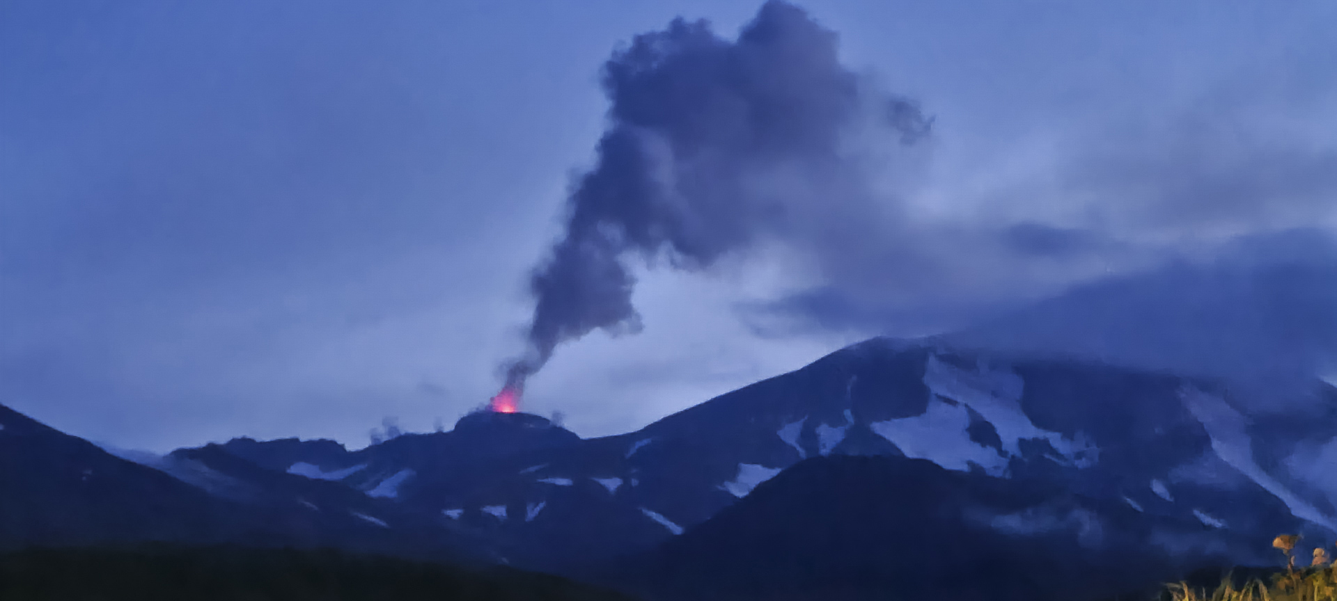 |
Figure 14. Photo of an active lava fountain at Great Sitkin at 0714 on 5 August 2021 as seen looking N from Adak Island. Photo by Peggy Kruse (AVO image 175201). |
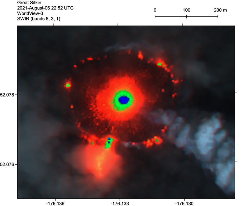 |
Figure 15. Lava dome growing on Great Sitkin on 6 August 2021, in a short-wave infrared (SWIR) false-color WorldView-3 satellite image. A lava tube breakout ~100 m long is visible through steam on the SSW margin. Courtesy of AVO (AVO image 175371). |
 |
Figure 16. Photo showing a steam plume rising from the dome at Great Sitkin at 0720 on 10 August 2021. Photo by Peggy Kruse (AVO image 175491). |
During September, seismicity remained elevated and was characterized by small earthquakes consistent with lava effusion. By mid-September, the edges of the dome touched the S and W rims of the crater, and lava began to advance though a gap in the S rim of the summit crater. By 24 September the dome had overtopped the S and W crater rims and lava flowed 305 m down the S flank and 195 m down the W flank. The dome was about 25 m thick and had grown to 1,170 m E to W and 925 m N to S in dimension.
By 3 October the dome had grown to 1,200 m E-W and 1,000 m N-S. Lava flows continued to advance down the S and SW flanks and were about 300-350 m long (figure 17). The SW lobe was descending two drainages and produced hot avalanches that traveled 450 m downslope on top of a snow field. Satellite images acquired on 11 October showed that lava filled more than half of the summit crater, flowing onto the S and W flanks, and had recently reached the N crater rim. Lava had traveled 330 m down the S flank, 350 m down the W flank, descended small valleys, and in some areas, advanced over snow and ice. Blocks that had detached from the end of the W flow descended 450 m. Analysis of satellite imagery on 25 October showed that the lava dome covered an area greater than 1 km2 and had overflowed the crater rim to the N, W, and S (figure 18). Elevated surface temperatures identified in satellite images during 25-26 October clearly showed the vent location (figure 19). By 30 October the lava had advanced about 680 m down the W flank, 560 m down the S flank, and 90 m down the N flank. During the latter part of October, seismicity remained slightly elevated and no explosions were recorded.
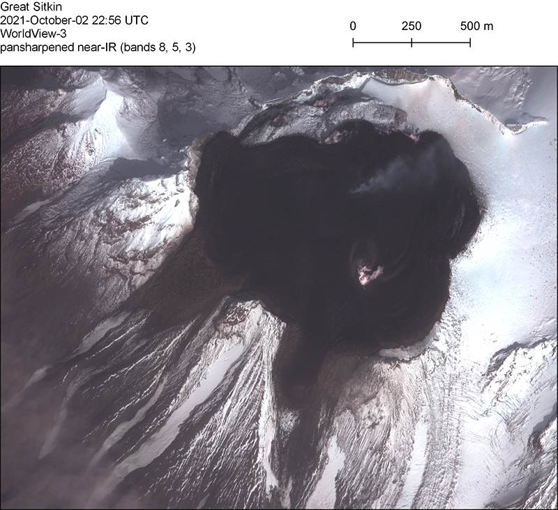 |
Figure 17. A pansharpened near-infrared WorldView-3 satellite image of Great Sitkin on 2 October 2021, showing lava flows and a small steam plume. Courtesy of AVO (AVO image 178461). |
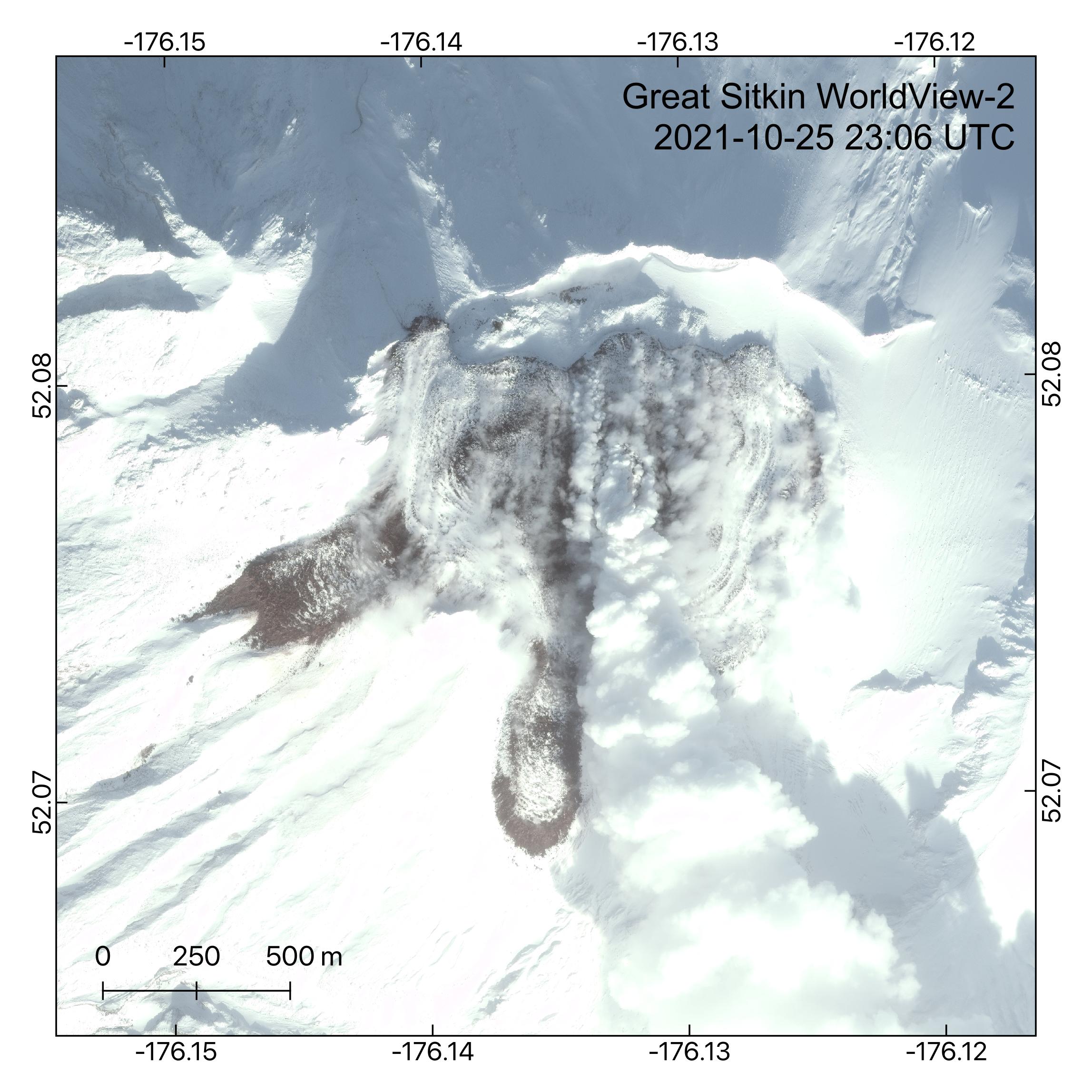 |
Figure 18. A visible WorldView-2 satellite image of Great Sitkin on 25 October 2021 shows the growing lava dome in the summit crater. At this point the dome covered an area greater than 1 km2 and had overflowed the crater rim to the N, W, and S. A steam plume can be seen extendings from the active vent region to the S. Courtesy of AVO (AVO image 178581). |
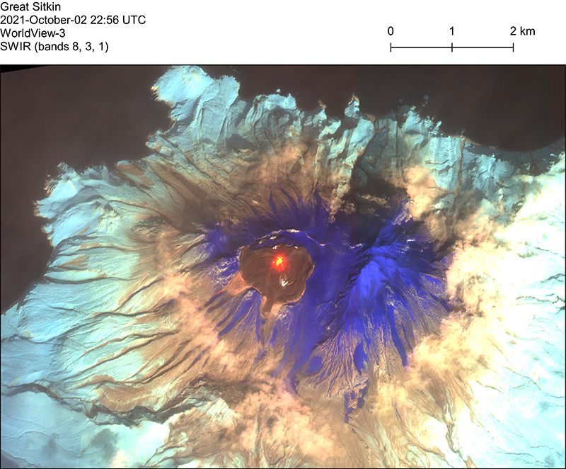 |
Figure 19. A short-wave infrared WorldView-3 satellite image of Great Sitkin on 25 October 2021. Red-orange areas represent high-temperature lava, purple is snow, light blue is vegetation, and browns to blacks are rock. Courtesy of AVO (AVO image 178481). |
By mid-November the lava flows on the N and W flanks had not progressed, but the S-flank flow had advanced to 650 m. According to AVO, satellite images acquired on 23 November showed that slow lava effusion continued. Lava continued to fill the summit crater and the flows on the flanks advanced short distances. During 24-30 November seismicity remained slightly above background levels. Elevated surface temperatures were periodically detected. Steam emissions were sometimes visible in webcam images. Slow lava effusion continued during December, and seismicity was very low, but persistent. A radar image acquired during 14-15 December showed a growing flow field with lava lobes advancing down the N, W, and S flanks. Crater surface temperatures remained elevated.
Based on AVO reports, activity continued to decrease during January-April 2022. Slow lava effusion continued during this period, along with very low but persistent seismicity (figure 20). Crater surface temperatures remained slightly elevated, and occasional steam emissions were observed. Lava flows continued to advance, and by mid-February lava flows had reached 1,050 m, 930 m, and 220 m down the S, W, and N flanks, respectively. Lava flows were also active on the SSW flank. An AVO report in March indicated that snow covered most of the flow except for the advancing fronts of the lava lobes and around the vent area. During the first week of April lava flows on the S, W, and N flanks advanced up to 10 m; elevated surface temperatures identified in satellite images during 8-10 April indicated continuing effusion. Steaming from the vent and flow field was occasionally seen in satellite images.
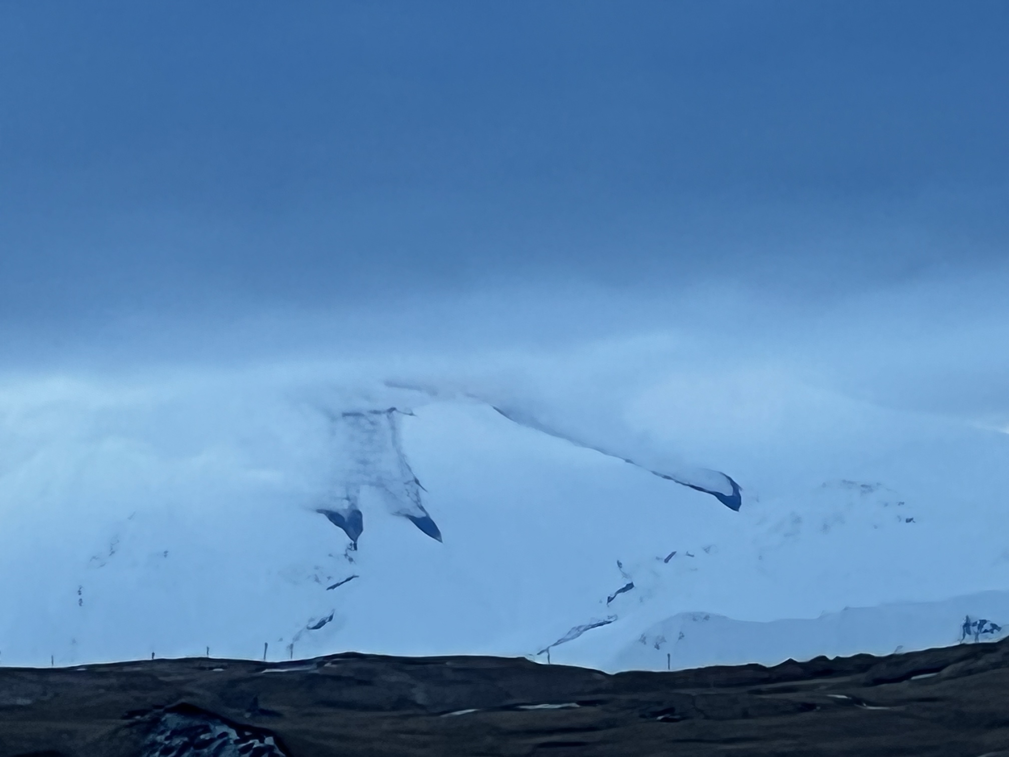 |
Figure 20. Photo of Great Sitkin taken from Adak Island on 14 January 2022 showing steam rising lava flows advancing through snow on the flanks. Photo by Steve Skeehan (AVO image 181451). |
Geological Summary. The Great Sitkin volcano forms much of the northern side of Great Sitkin Island. A younger volcano capped by a small, 0.8 x 1.2 km ice-filled summit caldera was constructed within a large late-Pleistocene or early Holocene scarp formed by massive edifice failure that truncated an older edifice and produced a submarine debris avalanche. Deposits from this and an even older debris avalanche from a source to the south cover a broad area of the ocean floor north of the volcano. The summit lies along the eastern rim of the younger collapse scarp. Deposits from an earlier caldera-forming eruption of unknown age cover the flanks of the island to a depth up to 6 m. The small younger caldera was partially filled by lava domes emplaced in 1945 and 1974, and five small older flank lava domes, two of which lie on the coastline, were constructed along northwest- and NNW-trending lines. Hot springs, mud pots, and fumaroles occur near the head of Big Fox Creek, south of the volcano. Eruptions have been recorded since the late-19th century.
Information Contacts: Alaska Volcano Observatory (AVO), a cooperative program of a) U.S. Geological Survey, 4200 University Drive, Anchorage, AK 99508-4667 USA (URL: https://avo.alaska.edu/), b) Geophysical Institute, University of Alaska, PO Box 757320, Fairbanks, AK 99775-7320, USA, and c) Alaska Division of Geological & Geophysical Surveys, 794 University Ave., Suite 200, Fairbanks, AK 99709, USA (URL: http://dggs.alaska.gov/); Sentinel Hub Playground (URL: https://www.sentinel-hub.com/explore/sentinel-playground); MIROVA (Middle InfraRed Observation of Volcanic Activity), a collaborative project between the Universities of Turin and Florence (Italy) supported by the Centre for Volcanic Risk of the Italian Civil Protection Department (URL: http://www.mirovaweb.it/); Hawai'i Institute of Geophysics and Planetology (HIGP) - MODVOLC Thermal Alerts System, School of Ocean and Earth Science and Technology (SOEST), Univ. of Hawai'i, 2525 Correa Road, Honolulu, HI 96822, USA (URL: http://modis.higp.hawaii.edu/).