Report on Sabancaya (Peru) — May 2022

Bulletin of the Global Volcanism Network, vol. 47, no. 5 (May 2022)
Managing Editor: Benjamin Andrews.
Edited by Kadie L. Bennis.
Sabancaya (Peru) Frequent low energy explosions, ash-and-gas plumes during October 2021-March 2022
Please cite this report as:
Global Volcanism Program, 2022. Report on Sabancaya (Peru) (Bennis, K.L., and Andrews, B., eds.). Bulletin of the Global Volcanism Network, 47:5. Smithsonian Institution. https://doi.org/10.5479/si.GVP.BGVN202205-354006
Sabancaya
Peru
15.787°S, 71.857°W; summit elev. 5960 m
All times are local (unless otherwise noted)
Sabancaya is located NE of Ampato and SE of Hualca Hualca volcanoes. Holocene activity has consisted of Plinian eruptions, followed by lava flow effusions, which have formed an extensive apron around the volcano on all sides except the south. Records of eruptions date back to 1750, with the most recent eruption beginning in November 2016, which has been characterized by daily explosions, ash emissions, thermal activity, and high levels of sulfur dioxide (BGVN 46:10). This activity continues during this reporting period of October 2021 through March 2022. The Observatorio Vulcanologico INGEMMET (OVI) reported daily on numbers of explosions, ash plume heights and directions of drift, seismicity, ashfall, and other activity; IGP (Instituto Geophysico del Peru) issued weekly reports of activity.
Activity during October 2021 through March 2022 consisted of tens of daily explosions, gas-and-steam plumes, strong sulfur dioxide emissions, and frequent thermal anomalies from the dome in the summit crater. Ash plumes rose 800-4,000 m above the summit and drifted in different directions. Daily sulfur dioxide measurements ranged from 400 and 5,600 tons/day, the largest of which took place on 5 January 2022. Some light ashfall was reported around the volcano during October and March. The Buenos Aires Volcanic Ash Advisory Center (VAAC) issued frequent reports of ash emissions that rose to 5.5-9.5 km altitude. Minor inflation continued to be detected near Hualca Hualca (4 km N).
Moderate levels of thermal activity were reported by the MIROVA project during October 2021 through March 2022; the intensity increased gradually during October, followed by a gradual decrease in November and continuing through mid-January 2022 (figure 111). Short breaks in activity occurred in late January through February, though the levels of these anomalies were relatively consistent. A total of 10 thermal alerts were detected by the MODVOLC system on 1, 17, and 19 November 2021, 4 January 2022, 5, 7, 12, and 21 February, and 13 and 25 March. Thermal anomalies were visible in Sentinel-2 infrared satellite images on clear weather days (figure 112). Moderate to strong sulfur dioxide plumes were recorded almost daily during the reporting period by the TROPOMI instrument on the Sentinel-5P satellite (figure 113). A majority of these plumes exceeded 2 Dobson Units (DU) and drifted in different directions.
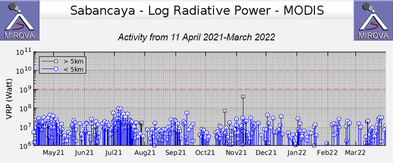 |
Figure 111. Frequent low-to-moderate strength thermal anomalies with some fluctuations occurred during October 2021 through March 2022 at Sabancaya, as shown in this MIROVA graph (Log Radiative Power). The strength of the anomalies increased gradually during October, then they were on a declining trend through mid-January 2022. Short breaks in activity occurred in late January through February, and the strength of the anomalies remained relatively consistent. Courtesy of MIROVA. |
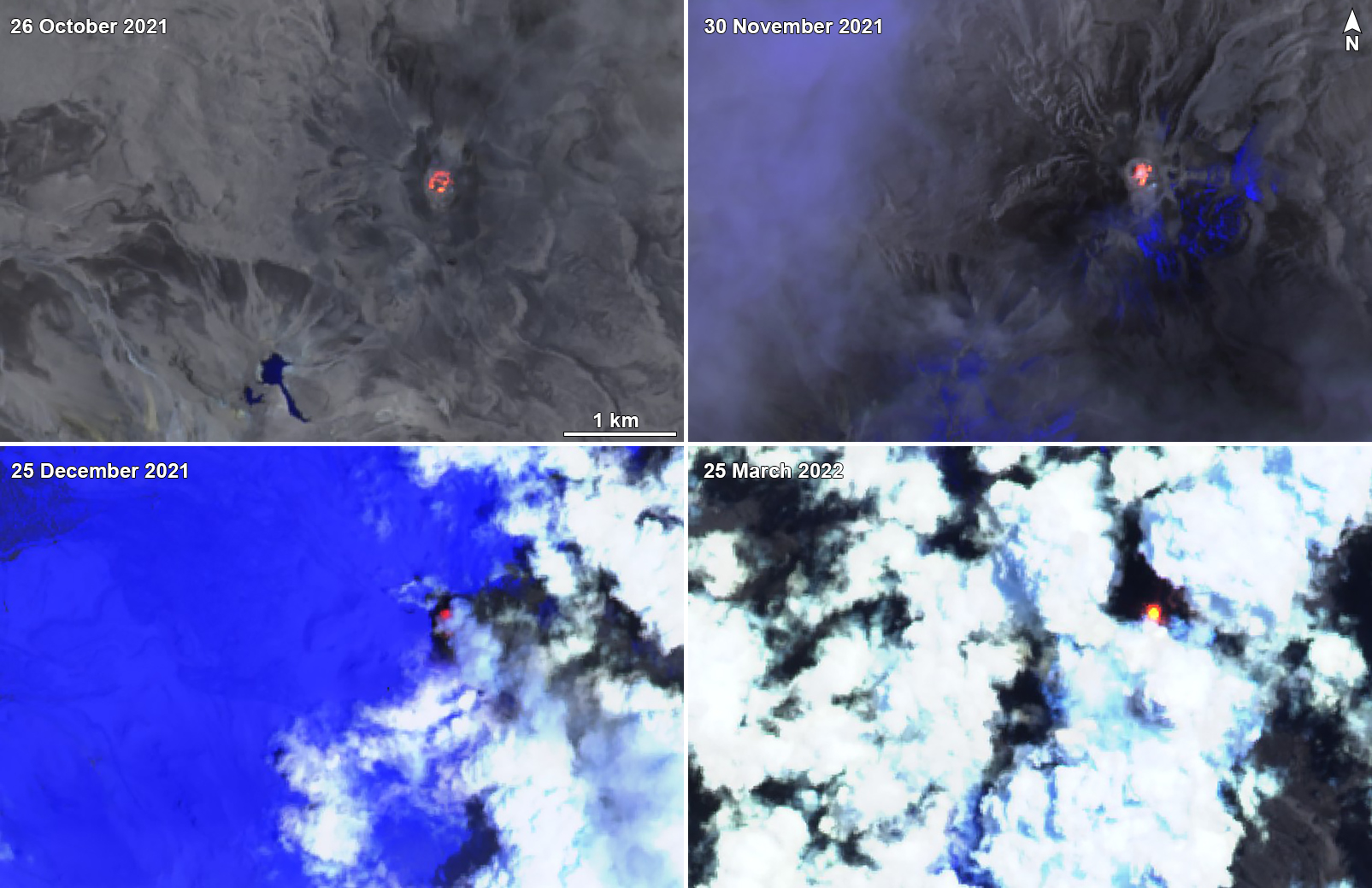 |
Figure 112. Sentinel-2 infrared satellite images of Sabancaya showed thermal anomalies in the summit crater on clear weather days on 26 October 2021 (top left), 30 November 2021 (top right), 25 December 2021 (bottom left), and 25 March 2022 (bottom right). Images use Atmospheric penetration rendering (bands 12, 11, 8a). Courtesy of Sentinel Hub Playground. |
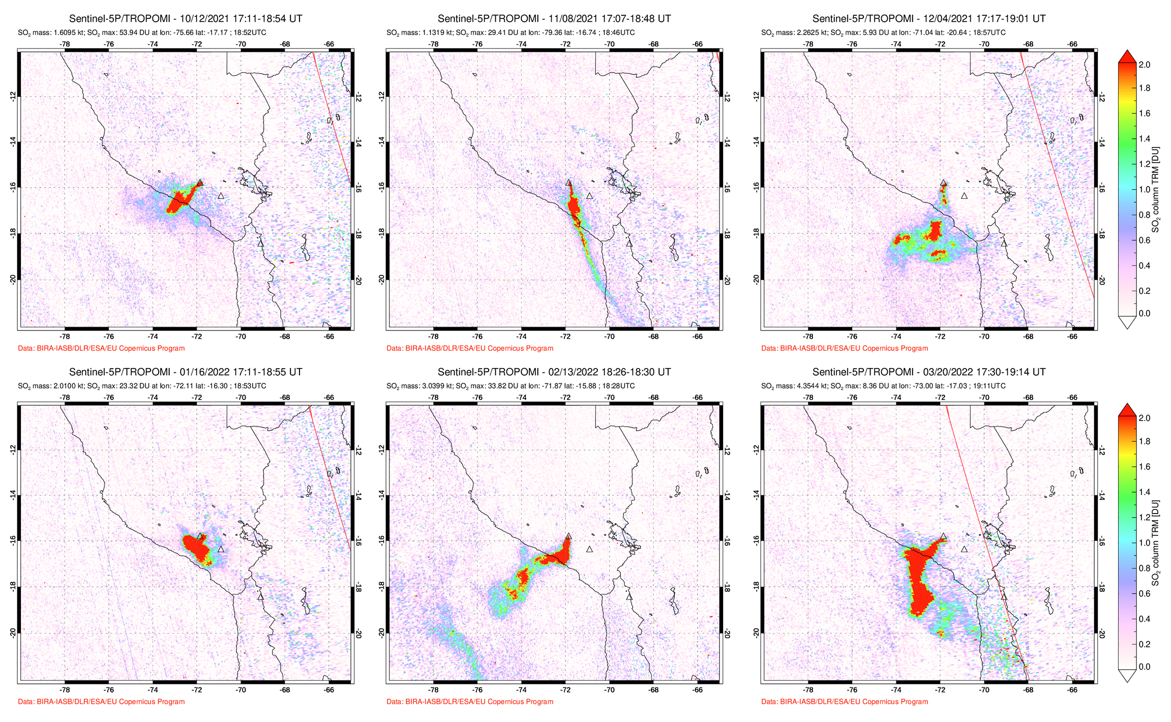 |
Figure 113. Strong sulfur dioxide plumes from Sabancaya were recorded by the TROPOMI instrument on the Sentinel-5P satellite during October 2021 through February 2022; the DU (Dobson Unit) density values were frequently greater than 2. Plumes from 12 October 2021 (top left), 8 November 2021 (top middle), 4 December 2021 (top right), 16 January 2022 (bottom left), 13 February 2022 (bottom middle), and 20 March 2022 (bottom right). Courtesy of NASA Global Sulfur Dioxide Monitoring Page. |
An average of 35 daily explosions were reported by IGP during October, generating gas-and-ash plumes 2-3.5 km above the summit that drifted in various directions (figure 114). A total of 4,486 volcanic earthquakes were detected during the month, which included volcanic-tremor (VT) events. Frequent sulfur dioxide measurements ranged from 1,900 and 4,000 tons/day. Intermittent light ashfall was reported in towns to the SW and NE, including Lluta, Taya, Mocca, Cuñirca, Achoma, Ichupampa, and Yanque. During November, an average of 70 daily explosions were detected, which produced gas-and-ash plumes to 2-2.5 km altitude above the summit. There were 2,846 volcanic earthquakes recorded during the month, which included VT-type events.
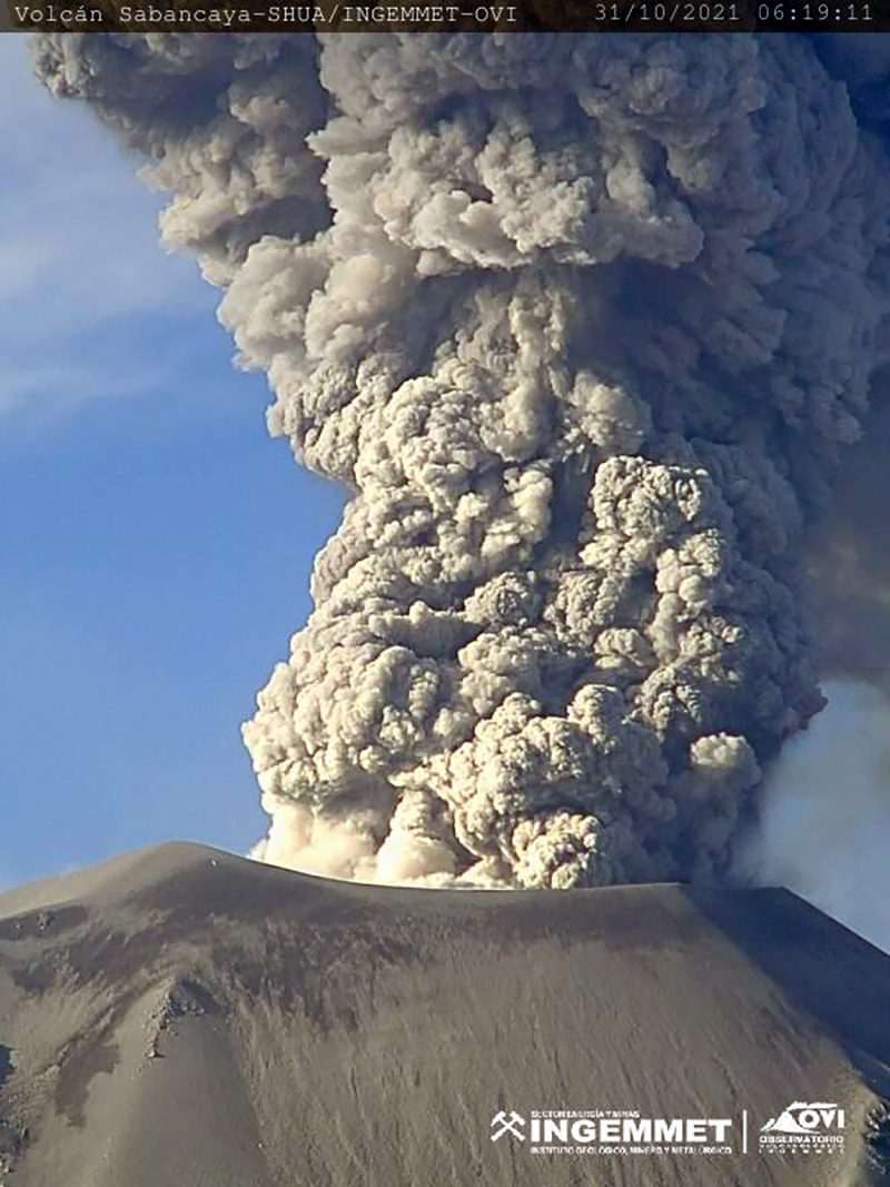 |
Figure 114. Photo of a gray ash plume rising from Sabancaya at 0619 on 31 October 2021. Courtesy of INGEMMET. |
During December 2021 and January 2022, IGP reported an average of 53 and 39 daily low energy explosions, respectively. These explosions generated ash-and-gas plumes that rose 1-4 km above the summit and drifted in different directions. About 2,777 volcanic earthquakes were recorded during December and 1,280 during January. Sulfur dioxide measurements ranged from 700 and 5,600 tons/day, the highest of which took place on 5 January. On 5 January an ash-and-gas plume rose 2 km above the summit and drifted SW, accompanied by incandescent ejecta (figure 115).
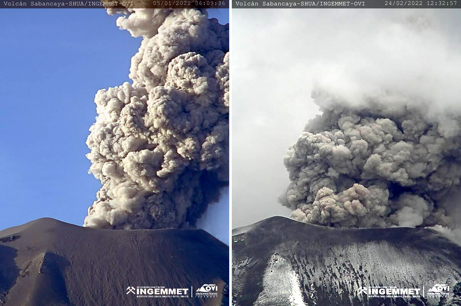 |
Figure 115. Photos of gray ash plumes rising from Sabancaya on 5 January 2022 (left) and 24 February 2022 (right). The plume on the left rose 2 km above the summit and drifted SW, while the one on the right rose 2.4 km above the summit and drifted SE. Courtesy of INGEMMET. |
Similar activity of ash-and-gas plumes and low energy explosions persisted during February and March; an average of 25 and 26 daily explosions were detected, respectively. Ash-and-gas plumes rose 800-3,000 m above the summit and drifted in multiple directions, especially NE and SE. On 24 February an ash-and-gas plume rose 2.4 km above the summit and drifted SE (figure 115). Some light ashfall was intermittently reported in villages surrounding the volcano on 4, 7-11, and 14-16 March; on 4 March, for example, it affected Pinchollo to the NE. About 662 volcanic earthquakes were detected during February and 756 during March. Sulfur dioxide measurements ranged from 400 and 5,000 tons/day, the highest of which was taken on 24 February.
Geological Summary. Sabancaya, located in the saddle NE of Ampato and SE of Hualca Hualca volcanoes, is the youngest of these volcanic centers and the only one to have erupted in historical time. The oldest of the three, Nevado Hualca Hualca, is of probable late-Pliocene to early Pleistocene age. The name Sabancaya (meaning "tongue of fire" in the Quechua language) first appeared in records in 1595 CE, suggesting activity prior to that date. Holocene activity has consisted of Plinian eruptions followed by emission of voluminous andesitic and dacitic lava flows, which form an extensive apron around the volcano on all sides but the south. Records of observed eruptions date back to 1750 CE.
Information Contacts: Observatorio Volcanologico del INGEMMET (Instituto Geológical Minero y Metalúrgico), Barrio Magisterial Nro. 2 B-16 Umacollo - Yanahuara Arequipa, Peru (URL: http://ovi.ingemmet.gob.pe); Instituto Geofisico del Peru (IGP), Calle Badajoz N° 169 Urb. Mayorazgo IV Etapa, Ate, Lima 15012, Perú (URL: https://www.igp.gob.pe/servicios/centro-vulcanologico-nacional/inicio); Buenos Aires Volcanic Ash Advisory Center (VAAC), Servicio Meteorológico Nacional-Fuerza Aérea Argentina, 25 de mayo 658, Buenos Aires, Argentina (URL: http://www.smn.gov.ar/vaac/buenosaires/inicio.php); MIROVA (Middle InfraRed Observation of Volcanic Activity), a collaborative project between the Universities of Turin and Florence (Italy) supported by the Centre for Volcanic Risk of the Italian Civil Protection Department (URL: http://www.mirovaweb.it/); Hawai'i Institute of Geophysics and Planetology (HIGP) - MODVOLC Thermal Alerts System, School of Ocean and Earth Science and Technology (SOEST), Univ. of Hawai'i, 2525 Correa Road, Honolulu, HI 96822, USA (URL: http://modis.higp.hawaii.edu/); NASA Global Sulfur Dioxide Monitoring Page, Atmospheric Chemistry and Dynamics Laboratory, NASA Goddard Space Flight Center (NASA/GSFC), 8800 Greenbelt Road, Goddard MD 20771, USA (URL: https://so2.gsfc.nasa.gov/); Sentinel Hub Playground (URL: https://www.sentinel-hub.com/explore/sentinel-playground).