Report on Barren Island (India) — June 2022

Bulletin of the Global Volcanism Network, vol. 47, no. 6 (June 2022)
Managing Editor: Edward Venzke.
Edited by Kadie L. Bennis.
Barren Island (India) Ash emissions in early January 2022, and notable thermal anomalies through the month
Please cite this report as:
Global Volcanism Program, 2022. Report on Barren Island (India) (Bennis, K.L., and Venzke, E., eds.). Bulletin of the Global Volcanism Network, 47:6. Smithsonian Institution. https://doi.org/10.5479/si.GVP.BGVN202206-260010
Barren Island
India
12.278°N, 93.858°E; summit elev. 354 m
All times are local (unless otherwise noted)
The remote island of Barren Island is located east of India in the Andaman Islands. Eruptions date back to 1787, with activity consisting of ash plumes, Strombolian explosions, and lava flows. The most recent eruption began in September 2018, with activity that included ash emissions and thermal anomalies (BGVN 46:12). This report covers similar activity during September 2021 through May 2022 using various satellite data as a primary source of information. Apparent eruptive activity continued until the end of January 2022, after which there was ongoing heat detected from the upper flanks of the central cone for a few months and a stronger thermal anomaly in the crater on 15 May.
The Suomi NPP/VIIRS sensor data showed 11 thermal anomalies over eight days on 14 and 19 October, 29-31 December 2021, and 1, 2, and 6 January 2022. Two MODVOLC thermal alerts were issued on 16 January 2022. Some of this thermal activity was visible in Sentinel-2 infrared satellite imagery on clear weather days on 6, 11, 21, and 31 December 2021, and 5, 25, and 30 January 2022 (figure 55).
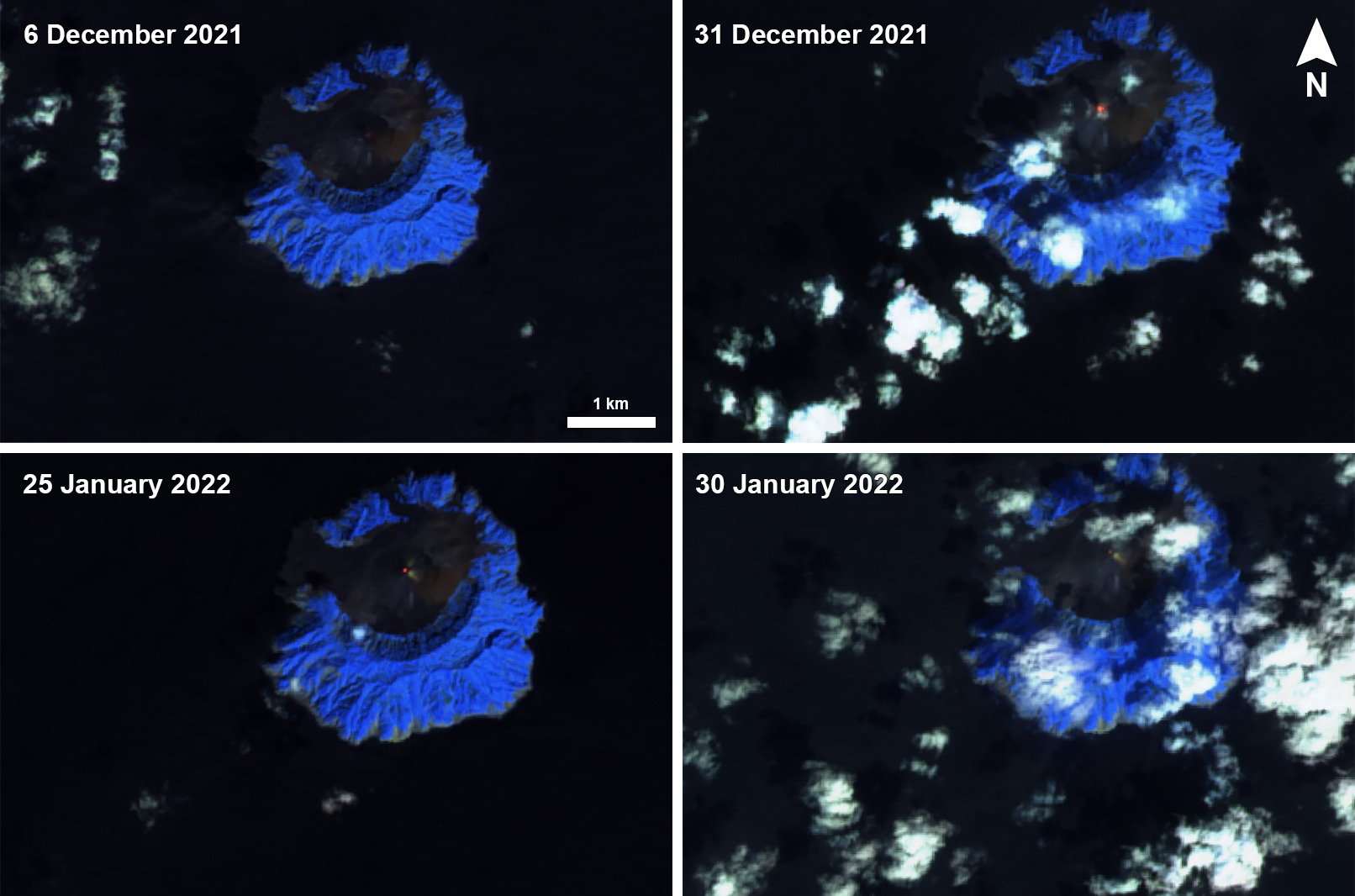 |
Figure 55. Weak thermal anomalies were visible at the summit crater of Barren Island on 6 and 31 December 2021 (top left and right) and 25 and 30 January 2022 (bottom left and right). The anomalies were stronger on 31 December and 25 January. Images using “Atmospheric penetration” rendering (bands 12, 11, 8a). Courtesy of Sentinel Hub Playground. |
A continuous ash emission was reported during 1700-2200 on 8 January 2022 that rose to 1.2 km altitude and drifted WNW, according to visible and RGB satellite images from HIMAWARI-8. Ash plumes were also visible during 1200-1700 on 9 January, rising to 1.2 km altitude and drifting W to SW, based on data from the HIMAWARI-8 satellite, according to the Darwin VAAC.
The MIROVA thermal anomaly data from September 2021 through May 2022 showed intermittent low- to moderate-levels of thermal activity, with the greatest number of anomalies (12) occurring in March 2022 (figure 56). By May, only two were detected. After January 2022 no thermal anomalies were detected in Sentinel-2 infrared images, Suomi NPP/VIIRS sensor data, or MODVOLC thermal data until 15 May, when a weak thermal hotspot was visible in infrared satellite data at the summit crater (figure 57).
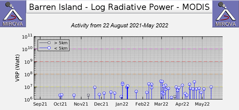 |
Figure 56. The MIROVA thermal anomaly data (Log Radiative Power) from September 2021 through May 2022 showed intermittent low to moderate levels of thermal activity beginning in early October. The number of anomalies increased slightly during March through May 2022. Three low-power anomalies were recorded in October, two in November, four in December 2021, six in January 2022, five in February, twelve in March nine in April, and two in May. Courtesy of MIROVA. |
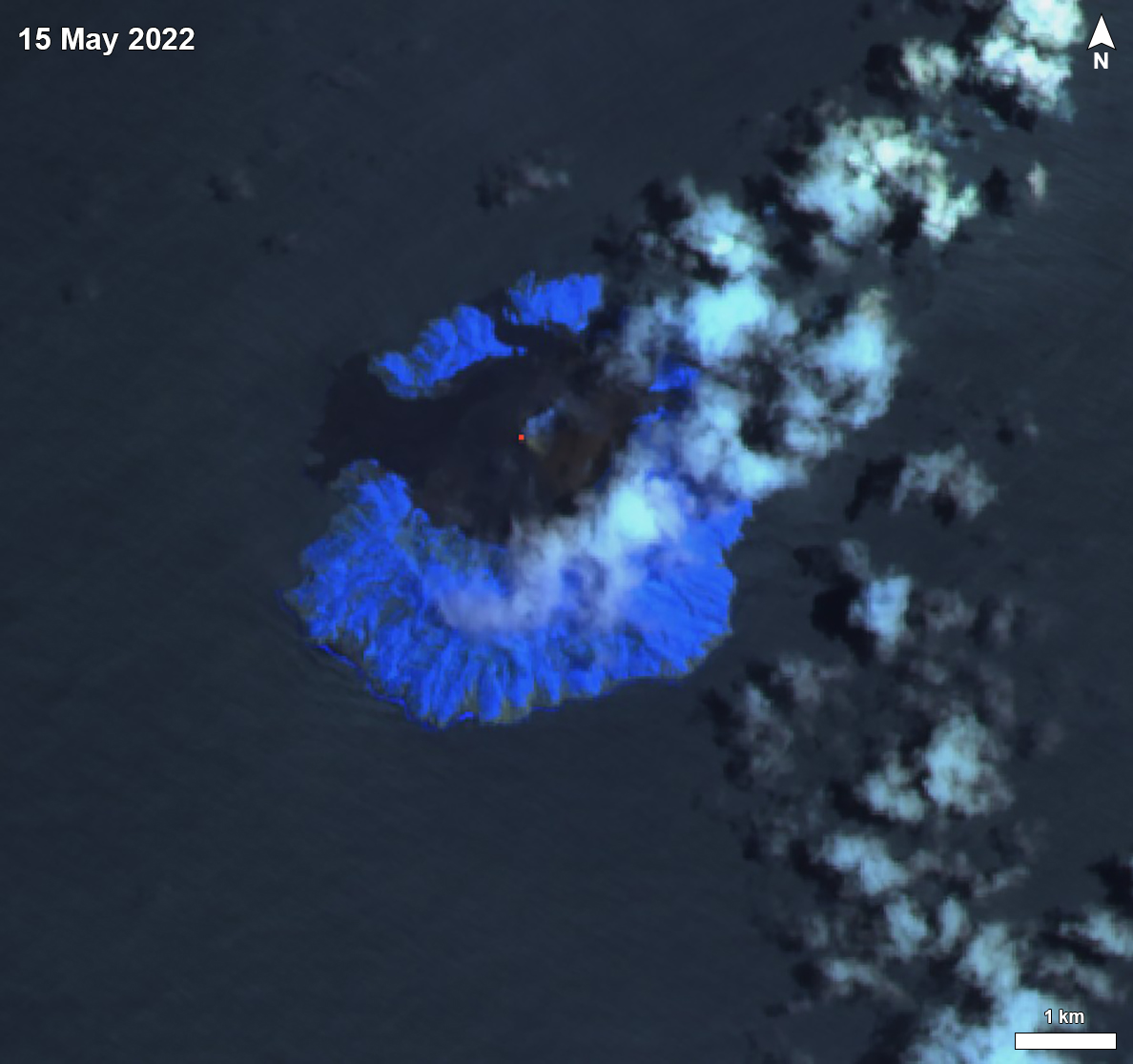 |
Figure 57. A single weak thermal anomaly was detected at the summit of Barren Island on 15 May 2022 in Sentinel-2 satellite imagery, accompanied by weak gas-and-steam emissions moving NE. Image using “Atmospheric penetration” rendering (bands 12, 11, 8a). Courtesy of Sentinel Hub Playground. |
Geological Summary. Barren Island, a possession of India in the Andaman Sea about 135 km NE of Port Blair in the Andaman Islands, is the only historically active volcano along the N-S volcanic arc extending between Sumatra and Burma (Myanmar). It is the emergent summit of a volcano that rises from a depth of about 2250 m. The small, uninhabited 3-km-wide island contains a roughly 2-km-wide caldera with walls 250-350 m high. The caldera, which is open to the sea on the west, was created during a major explosive eruption in the late Pleistocene that produced pyroclastic-flow and -surge deposits. Historical eruptions have changed the morphology of the pyroclastic cone in the center of the caldera, and lava flows that fill much of the caldera floor have reached the sea along the western coast.
Information Contacts: Darwin Volcanic Ash Advisory Centre (VAAC), Bureau of Meteorology, Northern Territory Regional Office, PO Box 40050, Casuarina, NT 0811, Australia (URL: http://www.bom.gov.au/info/vaac/); MIROVA (Middle InfraRed Observation of Volcanic Activity), a collaborative project between the Universities of Turin and Florence (Italy) supported by the Centre for Volcanic Risk of the Italian Civil Protection Department (URL: http://www.mirovaweb.it/); Hawai'i Institute of Geophysics and Planetology (HIGP) - MODVOLC Thermal Alerts System, School of Ocean and Earth Science and Technology (SOEST), Univ. of Hawai'i, 2525 Correa Road, Honolulu, HI 96822, USA (URL: http://modis.higp.hawaii.edu/); Sentinel Hub Playground (URL: https://www.sentinel-hub.com/explore/sentinel-playground); NASA Worldview (URL: https://worldview.earthdata.nasa.gov/).