Report on Karangetang (Indonesia) — July 2022

Bulletin of the Global Volcanism Network, vol. 47, no. 7 (July 2022)
Managing Editor: Edward Venzke.
Edited by Kadie L. Bennis.
Karangetang (Indonesia) Weak thermal activity during January-June 2022
Please cite this report as:
Global Volcanism Program, 2022. Report on Karangetang (Indonesia) (Bennis, K.L., and Venzke, E., eds.). Bulletin of the Global Volcanism Network, 47:7. Smithsonian Institution. https://doi.org/10.5479/si.GVP.BGVN202207-267020
Karangetang
Indonesia
2.781°N, 125.407°E; summit elev. 1797 m
All times are local (unless otherwise noted)
Karangetang (also known as Api Siau), located on the island of Siau in the Sitaro Regency, consists of two active summit craters: Kawah Dua (the N crater) and Kawah Utama (the S crater, also referred to as the “Main Crater”). Twentieth century eruptions have included frequent explosive activity, sometimes accompanied by pyroclastic flows and lahars. The most recent eruption period began in November 2018 and has more recently consisted of weak thermal anomalies, intermittent ash plumes, and gas-and-steam emissions (BGVN 47:01). Similar activity occurred during this report of January through June 2022, with continued white-to-gray gas-and-steam emissions and thermal anomalies, described in reports from the Pusat Vulkanologi dan Mitigasi Bencana Geologi (PVMBG, also known as CVGHM, or the Center of Volcanology and Geological Hazard Mitigation), MAGMA Indonesia, and satellite data.
Activity was relatively low during this reporting period. Bluish white gas-and-steam emissions drifted S on 2 January and intermittent white-and-gray plumes typically rose 25-250 m above the summit through June (figure 55). On 15 and 16 January gas-and-steam emissions rose as high as 500 m. Intermittent N summit crater incandescence was reported by PVMBG during early January 2022, which was sometimes detected in satellite data. MIROVA (Middle InfraRed Observation of Volcanic Activity) analysis of MODIS satellite data detected very low power thermal anomalies during late January (3), late April (1), and early May (1). Sentinel-2 infrared thermal satellite imagery showed small thermal anomalies in both the N and S summit craters on 8 January, 27 February, 9 March, 18 and 28 April, 3 May, and 2, 17, 22, and 27 June, accompanied by gas-and-steam emissions that drifted in different directions (figure 56).
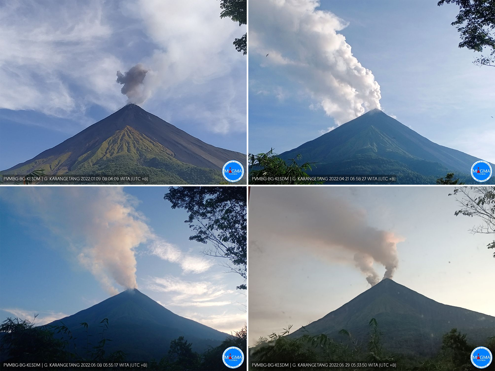 |
Figure 55. Webcam images of Karangetang showing white-to-gray plumes rising above both summit craters on 9 January 2022 (top left), 21 April 2022 (top right), 8 June 2022 (bottom left), and 29 June 2022 (bottom right). Courtesy of MAGMA Indonesia. |
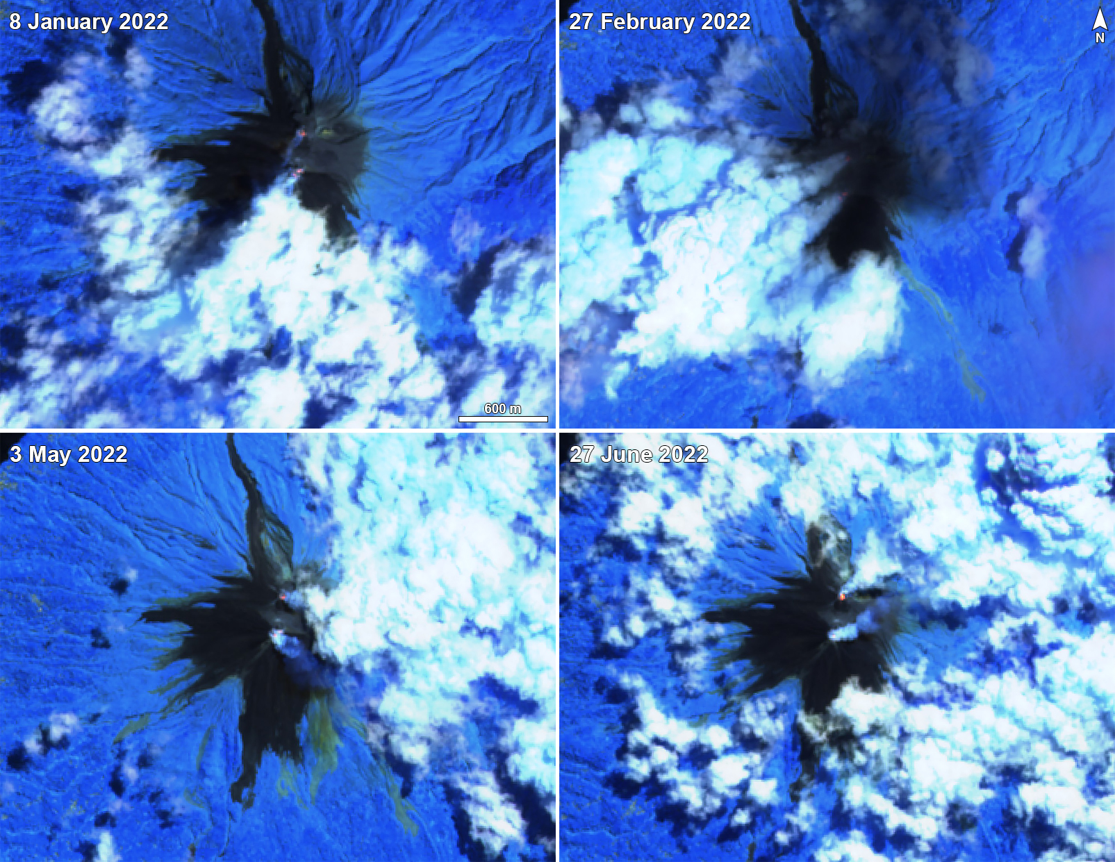 |
Figure 56. Small thermal anomalies (bright yellow-orange) at Karangetang were detected in the N and S summit craters on 8 January 2022 (top left), 27 February 2022 (top right), 3 May 2022 (bottom left), and 27 June 2022 (bottom right). Thermal anomalies from both craters were accompanied by gas-and-steam plumes that drifted in different directions. Images using “Atmospheric penetration” rendering (bands 12, 11, 8a). Courtesy of Sentinel Hub Playground. |
Geological Summary. Karangetang (Api Siau) volcano lies at the northern end of the island of Siau, about 125 km NNE of the NE-most point of Sulawesi. The stratovolcano contains five summit craters along a N-S line. It is one of Indonesia's most active volcanoes, with more than 40 eruptions recorded since 1675 and many additional small eruptions that were not documented (Neumann van Padang, 1951). Twentieth-century eruptions have included frequent explosive activity sometimes accompanied by pyroclastic flows and lahars. Lava dome growth has occurred in the summit craters; collapse of lava flow fronts have produced pyroclastic flows.
Information Contacts: Pusat Vulkanologi dan Mitigasi Bencana Geologi (PVMBG, also known as Indonesian Center for Volcanology and Geological Hazard Mitigation, CVGHM), Jalan Diponegoro 57, Bandung 40122, Indonesia (URL: http://www.vsi.esdm.go.id/); MAGMA Indonesia, Kementerian Energi dan Sumber Daya Mineral (URL: https://magma.esdm.go.id/v1); MIROVA (Middle InfraRed Observation of Volcanic Activity), a collaborative project between the Universities of Turin and Florence (Italy) supported by the Centre for Volcanic Risk of the Italian Civil Protection Department (URL: http://www.mirovaweb.it/); Sentinel Hub Playground (URL: https://www.sentinel-hub.com/explore/sentinel-playground).