Report on Ol Doinyo Lengai (Tanzania) — August 2022

Bulletin of the Global Volcanism Network, vol. 47, no. 8 (August 2022)
Managing Editor: Edward Venzke.
Edited by Kadie L. Bennis.
Ol Doinyo Lengai (Tanzania) Ongoing thermal activity in the crater during November 2021-July 2022
Please cite this report as:
Global Volcanism Program, 2022. Report on Ol Doinyo Lengai (Tanzania) (Bennis, K.L., and Venzke, E., eds.). Bulletin of the Global Volcanism Network, 47:8. Smithsonian Institution.
Ol Doinyo Lengai
Tanzania
2.764°S, 35.914°E; summit elev. 2962 m
All times are local (unless otherwise noted)
Ol Doinyo Lengai is located near the southern end of the East African Rift in Tanzania. It is known for its unique low-temperature carbonatitic lava. Activity primarily occurs in the crater offset to the north about 100 m below the summit where hornitos (small cones) and pit craters produce lava flows and spattering. Eruptions have been recorded since the late 19th century and the current eruption period began in April 2017. Recent activity has mostly consisted of small lava flows in the summit crater (BGVN 46:11). This report covers similar effusive activity during November 2021 through July 2022 using information primarily from satellite data.
Activity remained relatively low during this reporting period; satellite views were occasionally blocked by weather clouds. The MIROVA (Middle InfraRed Observation of Volcanic Activity) volcano hotspot detection system based on the analysis of MODIS data showed a total of 12 thermal anomalies: one in late November 2021, two in January 2022, one in early March, two in early May, four in late June, and two in July (figure 217). Thermal anomalies were intermittently visible in Sentinel-2 infrared satellite images on clear weather days dominantly in the center of the summit crater, possibly representing ongoing lava effusions from the central hornito (figure 218). On 9 November there were two small anomalies in the summit crater; one was located to the W side of the crater and smaller in size and the second was located offset to the E. Two larger anomalies were visible in the crater on 24 December offset to the SW and NE (figure 218).
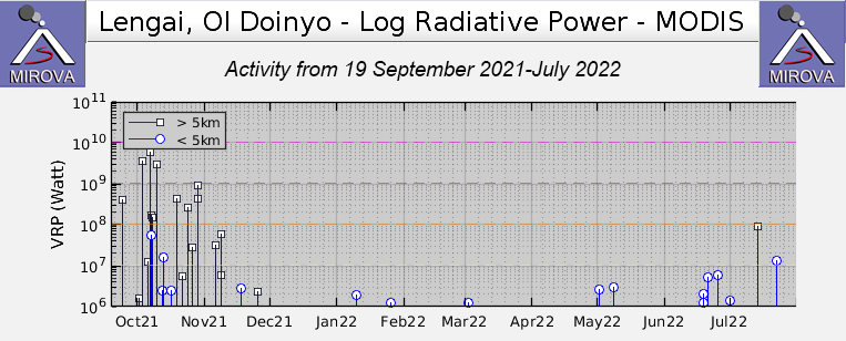 |
Figure 217. Thermal activity during November 2021-July 2022 at Ol Doinyo Lengai was relatively low in power, based on MODIS satellite data shown on this MIROVA graph (Log Radiative Power). A single anomaly was detected in late November; two during January 2022; one during early March; two during early May; four during late June; and two during July. Courtesy of MIROVA. |
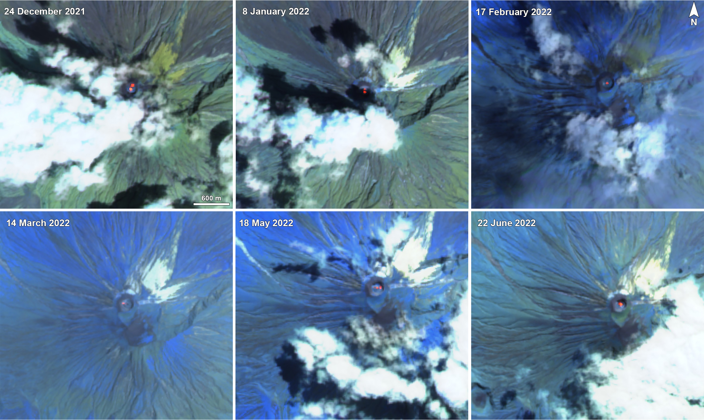 |
Figure 218. Sentinel-2 infrared imagery of Ol Doinyo Lengai from 24 December 2021 through 22 June 2022 showed thermal anomalies (bright yellow-orange) in the summit crater on clear weather days. On 24 December 2021 (top left) there were strong two anomalies offset slightly to the NE and SW side of the summit crater. On 8 January 2022 (top middle) two anomalies were visible: one in the center of the summit crater and the second close to the N side of the crater. On 17 February 2022 (top right) and 14 March 20220 (bottom left) a single anomaly was visible in the center of the crater. On 18 May three small anomalies occurred in the center of the crater and on the W and E side of the crater. On 22 June 2022 (bottom left) a stronger anomaly was visible in the center of the crater and also expanded toward the N side. Images use “Atmospheric penetration” rendering (bands 12, 11, 8A). Courtesy of Sentinel Hub Playground. |
On 8 January 2022 two anomalies occurred that have decreased in size compared to the ones in late December. One of these hotspots remained in the center of the crater while the second one was located to the N side of the crater. During 8 January through 13 May only a single central anomaly was visible in infrared satellite imagery. On 18 May two anomalies appeared again, one of which remained in the center while the second on drifted more to the E of the crater. The size of the anomaly increased on 12 June, filling up much of the center of the summit crater. This larger size remained visible through the end of July, according to satellite data. During late July, the intensity of the thermal anomalies increased slightly and were larger in size, as reflected in Sentinel-2 infrared satellite imagery (figure 219). This increase is also reflected in the stronger thermal anomaly detected in late July in the MIROVA graph. A single thermal alert was detected by the MODVOLC system on 22 July.
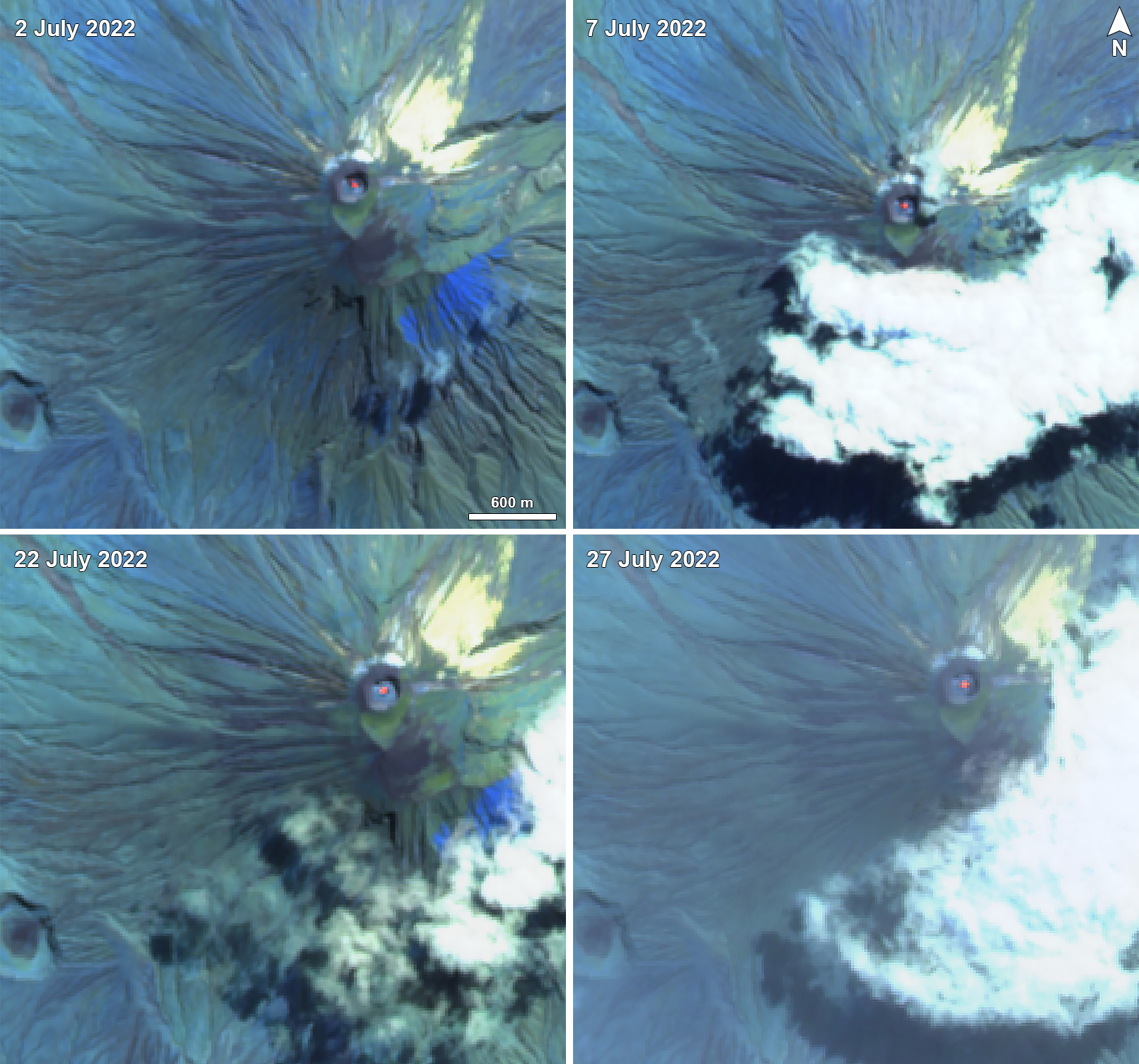 |
Figure 219. Sentinel-2 infrared imagery of Ol Doinyo Lengai during July 2022 showed slightly stronger and consistent thermal anomalies (bright yellow-orange) in the center of the summit crater on clear weather day compared to the previous months. Images use “Atmospheric penetration” rendering (bands 12, 11, 8A). Courtesy of Sentinel Hub Playground. |
Geological Summary. The symmetrical Ol Doinyo Lengai is the only volcano known to have erupted carbonatite tephras and lavas in historical time. The prominent stratovolcano, known to the Maasai as "The Mountain of God," rises abruptly above the broad plain south of Lake Natron in the Gregory Rift Valley. The cone-building stage ended about 15,000 years ago and was followed by periodic ejection of natrocarbonatitic and nephelinite tephra during the Holocene. Historical eruptions have consisted of smaller tephra ejections and emission of numerous natrocarbonatitic lava flows on the floor of the summit crater and occasionally down the upper flanks. The depth and morphology of the northern crater have changed dramatically during the course of historical eruptions, ranging from steep crater walls about 200 m deep in the mid-20th century to shallow platforms mostly filling the crater. Long-term lava effusion in the summit crater beginning in 1983 had by the turn of the century mostly filled the northern crater; by late 1998 lava had begun overflowing the crater rim.
Information Contacts: MIROVA (Middle InfraRed Observation of Volcanic Activity), a collaborative project between the Universities of Turin and Florence (Italy) supported by the Centre for Volcanic Risk of the Italian Civil Protection Department (URL: http://www.mirovaweb.it/); Hawai'i Institute of Geophysics and Planetology (HIGP) - MODVOLC Thermal Alerts System, School of Ocean and Earth Science and Technology (SOEST), Univ. of Hawai'i, 2525 Correa Road, Honolulu, HI 96822, USA (URL: http://modis.higp.hawaii.edu/); Sentinel Hub Playground (URL: https://www.sentinel-hub.com/explore/sentinel-playground).