Report on Nyamulagira (DR Congo) — September 2022

Bulletin of the Global Volcanism Network, vol. 47, no. 9 (September 2022)
Managing Editor: Edward Venzke.
Research and preparation by Paul Berger.
Nyamulagira (DR Congo) Summit caldera lava flows and thermal anomalies continue during December 2021-August 2022
Please cite this report as:
Global Volcanism Program, 2022. Report on Nyamulagira (DR Congo) (Venzke, E., ed.). Bulletin of the Global Volcanism Network, 47:9. Smithsonian Institution.
Nyamulagira
DR Congo
1.408°S, 29.2°E; summit elev. 3058 m
All times are local (unless otherwise noted)
Nyamulagira (also known as Nyamuragira) is a shield volcano in the Democratic Republic of the Congo that hosts a lava lake in the summit crater. Recent activity has been characterized by lava effusion, thermal anomalies, seismicity, and gas-and-steam emissions (BGVN 45:12). The current report summarizes activity during December 2021-August 2022 and is based on satellite data.
The MODIS thermal sensors aboard the Aqua and Terra satellites processed using the MODVOLC algorithm (MODIS-MODVOLC) detected numerous hotspots at the volcano, consistent with the persistent lava lake in the summit crater. Days with hotspots increased during the reporting period, with 1-4 days per month during December 2021 through February, 7-8 days during March and April, and 10-12 days during May-August. Every month from May-August had at least one day with 4 pixels. The MIROVA (Middle InfraRed Observation of Volcanic Activity) system also detected numerous hotspots, with the frequency noticeably increasing starting in January 2022 (figure 91).
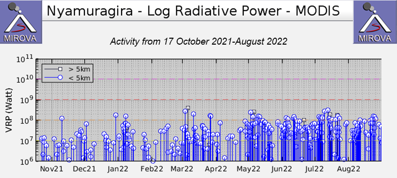 |
Figure 91. Numerous thermal anomalies at Nyamulagira during December 2021 through August 2022, according to the MIROVA graph (Log Radiative Power). Stronger pulses were apparent after May. Courtesy of MIROVA. |
Throughout the reporting period, hotspots were observed in every Sentinel-2 infrared image during the infrequent days when cloud conditions allowed an observation. Images showed that activity generally intensified over the reporting period, especially beginning in late April when effusive activity and surface lava was detected outside the NE pit crater. Infrared satellite imagery showed multiple areas of lava effusion and flows throughout the S and W parts of the caldera that changed with every available image (figure 92). This increased activity continued through the reporting period.
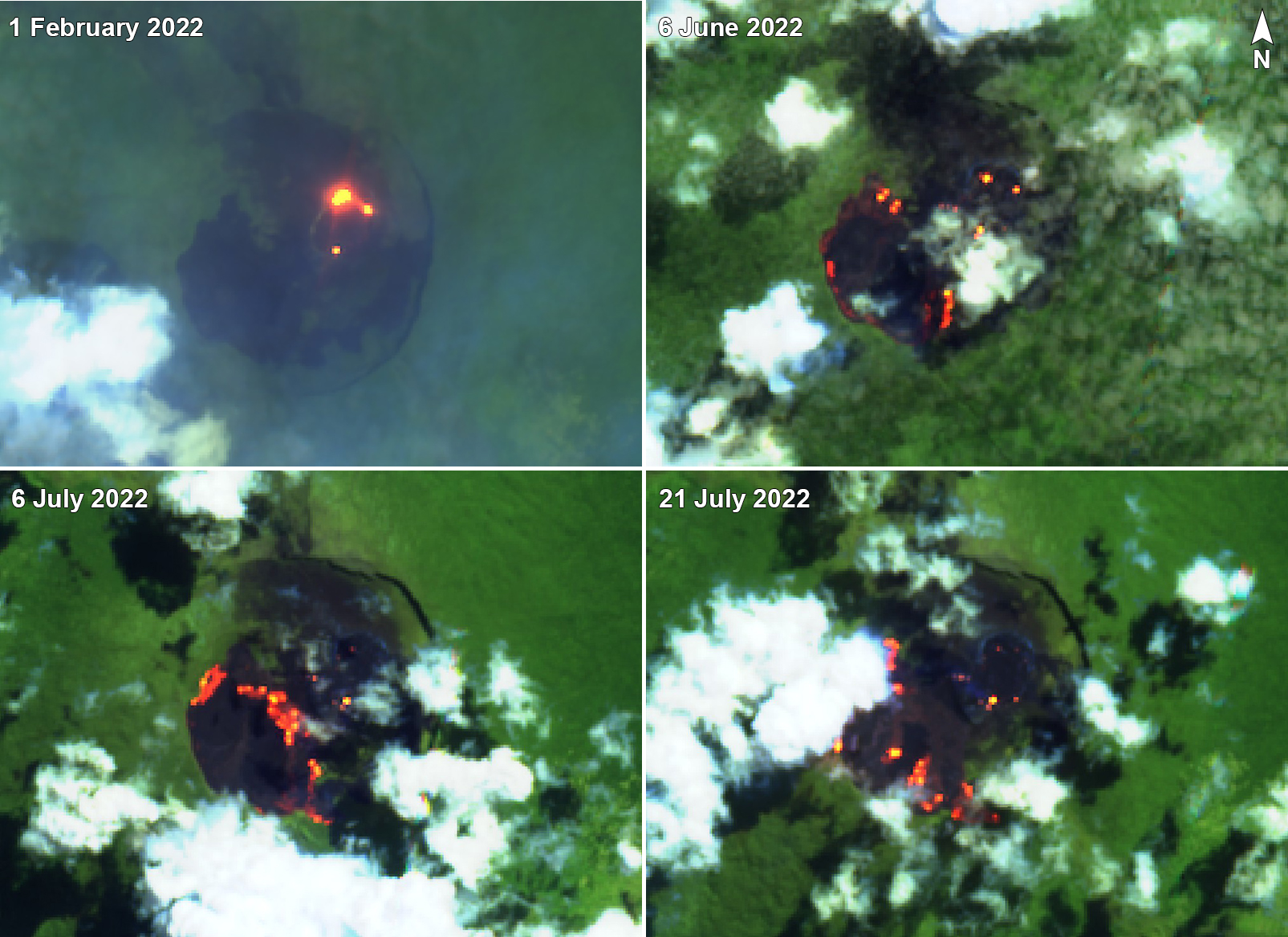 |
Figure 92. Sentinel-2 satellite images of Nyamulagira showed persistent strong thermal anomalies in 2022 through August. Thermal signals on 1 February 2022 were in the NE pit crater, typical of activity during December 2021-February 2022. Satellite images from 6 June, 6 July, and 21 July reveal multiple vent locations and lava flows across the S and W parts of the caldera, both in and around the large crater in that area. Images use false color (urban) rendering (bands 12, 11, 4). Courtesy of Sentinel Hub Playground. |
Geological Summary. Africa's most active volcano, Nyamulagira (also known as Nyamuragira), is a massive high-potassium basaltic shield about 25 km N of Lake Kivu and 13 km NNW of the steep-sided Nyiragongo volcano. The summit is truncated by a small 2 x 2.3 km caldera that has walls up to about 100 m high. Documented eruptions have occurred within the summit caldera, as well as from the numerous flank fissures and cinder cones. A lava lake in the summit crater, active since at least 1921, drained in 1938, at the time of a major flank eruption. Recent lava flows extend down the flanks more than 30 km from the summit as far as Lake Kivu; extensive lava flows from this volcano have covered 1,500 km2 of the western branch of the East African Rift.
Information Contacts: MIROVA (Middle InfraRed Observation of Volcanic Activity), a collaborative project between the Universities of Turin and Florence (Italy) supported by the Centre for Volcanic Risk of the Italian Civil Protection Department (URL: http://www.mirovaweb.it/); Hawai'i Institute of Geophysics and Planetology (HIGP) - MODVOLC Thermal Alerts System, School of Ocean and Earth Science and Technology (SOEST), Univ. of Hawai'i, 2525 Correa Road, Honolulu, HI 96822, USA (URL: http://modis.higp.hawaii.edu/); Sentinel Hub Playground (URL: https://www.sentinel-hub.com/explore/sentinel-playground).